Showing 1537 items matching "aerial photograph"
-
 Lakes Entrance Historical Society
Postcard - Backwater, Bulmer H D, 1922c
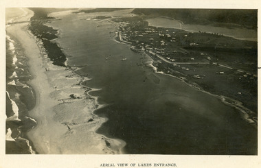
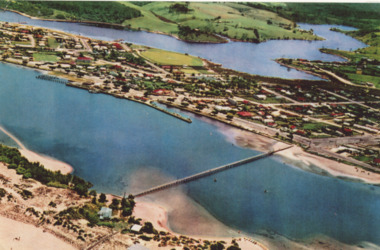
... Aerial Photograph...Islands Aerial Photograph Waterways Topography Township ...Black and white photographic postcard, showing early aerial view of township of Lakes Entrance, Cunninghame Arm, North Arm and sand dunes, ocean in lower foreground, Eastern wharf and various boats on lake. Princes Highway went along Esplanade, Myer Street and Roadknight Street, very little vegetation on sand dunes, no foot bridge yet, good view of North Arm, few houses. Lakes Entrance VictoriaLakes Entrance and Backwater from the Air.islands, aerial photograph, waterways, topography, township -
 Lakes Entrance Historical Society
Photograph - Lakes Entrance, 1923c
... Aerial Photograph...Black and white photograph showing early aerial view... Photograph Islands Township Aerial View of Lakes Entrance Black ...Two copies 16.5 x 25.5 very darkBlack and white photograph showing early aerial view of township of Lakes Entrance, photo shows highway going along Myer Street and along Roadknight Street, no shops in Myer Street appears to be no foot bridge, therefore taken prior to 1937, sparce vegetation on foreground dunes, four barriers built on dunes to stop erosion through sand, two masted sailing boat in lake. Bullock Island in distance appears very small, Snake Island of Rigby Island in centre distance. Lakes Entrance VictoriaAerial View of Lakes Entrancewaterways, coast, aerial photograph, islands, township -
 Lakes Entrance Historical Society
Postcard - Lakes Entrance, 1923c
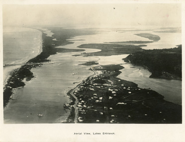
... Aerial Photograph...|Also copy black and white 9 x 14.5 Aerial Photograph Islands ...Also large postcard 15 x 20|Also two mini postcard 6 x 9|Also copy black and white 9 x 14.5Black and white postcard of an aerial view of township of Lakes Entrance, showing western end of town, jetties and boat harbours in Cunninghame Arm, the entrance and piers, North Arm bridge, Bullock Island, Rigby, Fraser and Flannegan Islands, and a distant view of Boole Poole, Bunga Arm and Lake King. Lakes Entrance VictoriaAn aerial view showing position of Lakes Entranceaerial photograph, islands, waterways, topography, township -
 Lakes Entrance Historical Society
Photograph - Jemmys Point Lakes Entrance, 1880 c
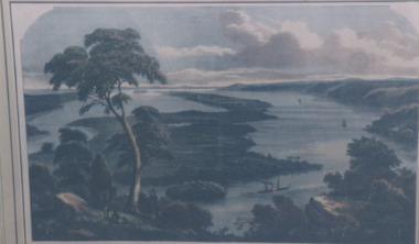
... Aerial Photograph...Aerial Photograph Township Topography Jemmys Point Lakes ...Colour photograph print of early painting of view from Jemmys Point towards Metung showing paddle steamer and Aboriginals in bottom left hand corner Rigby Fraser and Flannagan Islands centre of painting, The Barrier on the left Nungurner Hills on right Gippsland LakesEntrance to The Gippsland Lakesaerial photograph, township, topography, jemmys point lakes entrance -
 Lakes Entrance Historical Society
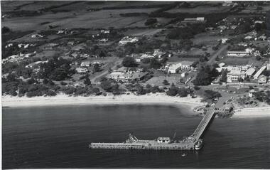
Photograph - Lakes Entrance, Brian Lloyd, 1954c
... Aerial Photograph... views in album Aerial Photograph Township Beaches Black ...Arial view of Lakes Entrance c1954. Plus 2 other arial views in albumBlack and white photograph of a section of the town taking in St Brendans church, Bulmer Street from Esplanade to Church Street, some of the waterfront, the footbridge and hummocks Lakes Entrance Victoriaaerial photograph, township, beaches -
 Lakes Entrance Historical Society
Photograph - Lakes Entrance, 1952c
... Aerial Photograph...Aerial Photograph Township Colour photograph of town from ...Colour photograph of town from Myers Street looking west showing footbridge, Cunninghamme Arm and North Arm Lakes Entrance Victoriaaerial photograph, township -
 Lakes Entrance Historical Society
Photograph, 2000 c
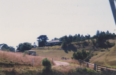
... Aerial Photograph... 15 cm Aerial Photograph Topography Township Colour photograph ...Also a similar colour photograph number 03861.1 size 10 x 15 cmColour photograph of Frenchman's Gully showing Wyanga Winery vehicle on winery track with property Taradale of Leigh and Judy Davies on opposite hill Lakes Entrance Victoriaaerial photograph, topography, township -
 Lakes Entrance Historical Society
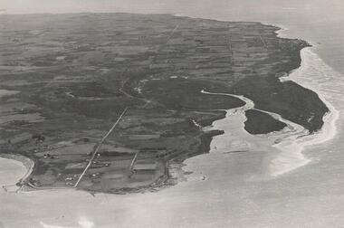
Photograph - Jemmys Point Lakes Entrance, Tidy Town Committee, 1996 c
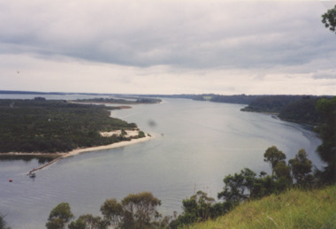
... Aerial Photograph... 15 cm Aerial Photograph Township Topography Waterways Jemmys ...Also a second similar photograph number 03875.1 size 10 x 15 cmColour photograph taken from Jemmys Point looking west through the Gippsland Lakes to Metung with Rigby, Fraser and Flannagan Islands to the south Kalimna Victoriaaerial photograph, township, topography, waterways, jemmys point lakes entrance -
 Lakes Entrance Historical Society
Photograph - Lake Tyers Beach Caravan Park, Jan. 1983
... Aerial Photograph...Aerial Photograph Caravan Parks Beaches Colour Photograph ...Colour Photograph of Ninety Mile Beach caravan Park at Lake Tyers Beach Victoria. Shows house rooftop, caravans and LTB Road on right hand side aerial photograph, caravan parks, beaches -
 Lakes Entrance Historical Society
Photograph - North Arm Lakes Entrance, Lakes Post Newspaper, Frenchman's Gully, Lakes Entrance Victoria, 1996 c
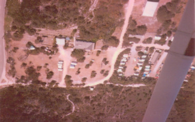
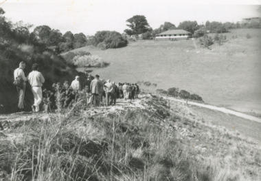
... Aerial Photograph...Aerial Photograph Topography Settlement Lakes Entrance ...Black and white photograph of Frenchman's Gully, track to Wyanga Winery showing group of people walking towards designated pickup spot for Winery bus Lakes Entrance Victoriaaerial photograph, topography, settlement, lakes entrance -
 City of Moorabbin Historical Society (Operating the Box Cottage Museum)
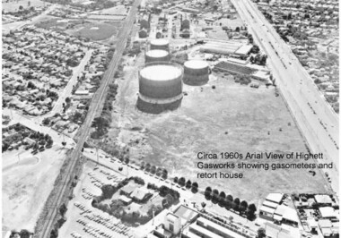
Photograph - Photographs of Highett Gasworks, Gasometer, Retort House and Coal Store at Highett Gasworks, 1974 and 1960
... On the back of the two coloured photographs "Highett... kerosene On the back of the two coloured photographs "Highett ...Gasometers resulted from complex engineering design evolving from primitive gasholders first used in 1824 in England to power street lights. The 20th century gasometer, (as used at the Highett Gasworks), was comprised of a series of large interconnected, telescopic, cylindrical vessels or lifts, which rose and fell depending on the volume of gas stored. The gasholder operated on a basic principle of a gas-filled floating vessel, rising and falling in a seal of water. The Highett Gasworks had its beginning in 1939 but its beginnings commenced sixty-two years earlier when the privately owned Brighton Gas Company was floated in 1877. By 1880 the company was performing well and making excellent profits. The company was welcomed by residents wanting to replace the shadowy light of a kerosene lamp with the bright luminescence of "modern" gas lamps. The land developers of the day were also keen supporters. But by 1884 people became disgrunted because either the gas had not reached them yet or because the quality of the supply had diminished due to the increasing use. In 1885 a second private gas company, the Central Brighton and Moorabbin Gas Co, Chaired by "Tommy" Bent was floated and for many years the two gas companies enjoyed a shared monopoly in supplying gas from their New Street Works. In the 1930s the company expanded its gas production facilities to Highett where it had purchased 45 acres of land adjacent to the Melbourne-Frankston railway line. A gasholder with a capacity of 750,000 cubic feet was erected on the Highett land in 1927 and connected with high pressure mains to the Brighton works. Three years later the company directors decided to proceed with the construction of a vertical retort house and coal store. Following a "lull" during the Great Depression work recommenced in 1936 and by 1939 the first complete gas-making plant was completed, and gas making commenced. Over the next twenty one years other significant extensions occurred, including an amenities block to accomodate 100 workers. In 1969 Esso commenced the introduction of natural gas to residents homes and the gradual decommissioning of the Highett Gasworks commenced. Part of the old Highett Gasworks site is now a council owned parkThe photos of the Higett Gasworks, now demolished, recall their long history, that originated in the 1800s with the production of gas to supply homes with a new, much improved light source, and later it's other applications such as for stoves etc. The arrival of gas in the Shire of Moorabbin was a huge step forward that encouraged further building and development in the area.Three Photographs of the Highett Gasworks. Two are coloured photos taken in 1974, and one is black and white taken in the 1960s. All are in good conditionOn the back of the two coloured photographs "Highett Gasworks 1974" No inscription on the black and white aerial photograph.brighton, moorabbin, highett, bent thomas, gasometer, highett gasworks, engineering design, brighton gas company, central brighton and moorabbin gas company, great depression, lamp kerosene -
 Orbost & District Historical Society
black and white photograph
... A black / white aerial photograph of a sawmill in Orbost.... gippsland timber-industry-orbost sawmill A black / white aerial ...A black / white aerial photograph of a sawmill in Orbost.timber-industry-orbost sawmill -
 Phillip Island and District Historical Society Inc.
Photograph
... Aerial photograph of Churchill Island taken in 1939.... photograph coastline islands Churchill Island Aerial view John Jenner ...One of a collection of over 400 photographs in an album commenced in 1960 and presented to the Phillip Island & Westernport Historical Society by the Shire of Phillip IslandAerial photograph of Churchill Island taken in 1939.local history, photography, churchill island, black & white photograph, coastline, islands, churchill island aerial view, john jenner, bryant west -
 Whitehorse Historical Society Inc.
Map, Blackburn Lake, c1968
... Enlarged aerial photograph of Blackburn Lake area.... Lake Road Blackburn Central Road Blackburn Aerial photographs ...Enlarged aerial photograph of Blackburn Lake area.Enlarged aerial photograph of Blackburn Lake area.Enlarged aerial photograph of Blackburn Lake area.blackburn lake sanctuary, adult deaf & dumb home, lake road, blackburn, central road, blackburn, aerial photographs -
Whitehorse Historical Society Inc.
Map, Blackburn Lake, 1960s
... Aerial photograph of Blackburn Lake Sanctuary 1960s.... Mitcham melbourne Aerial photographs Blackburn Lake Sanctuary ...Aerial photograph of Blackburn Lake Sanctuary 1960s.Aerial photograph of Blackburn Lake Sanctuary 1960s.Aerial photograph of Blackburn Lake Sanctuary 1960s.aerial photographs, blackburn lake sanctuary -
 Ballarat Heritage Services
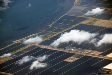
Digital photographs, Werribee farm from the air, c2016
... Aerial photograph of the Werribee Sewerage Farm, Victoria.... MEtropolitan Board of Works sewerage Aerial photograph of the Werribee ...Aerial photograph of the Werribee Sewerage Farm, Victoria.werribee farm, mmbw, aerial, melbourne metropolitan board of works, sewerage -
 Kew Historical Society Inc
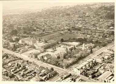
Photograph - Digital Image, Methodist Ladies' College Hawthorn from the Air, 2020
... Aerial photograph of Methodist Ladies' College, Hawthorn.... photographs Aerial photograph of Methodist Ladies' College, Hawthorn ...Digital image of MLC Kew from a photograph album belonging to Judith Scurfield.Aerial photograph of Methodist Ladies' College, Hawthorn.methodist ladies' college - kew (vic), aerial photographs -
 Orbost & District Historical Society
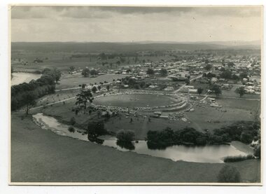
black and white photographs, March 10 1961
... Four black / white aerial photographs. there are spare... and in detail. They are useful for reference. photographs-aerial-Orbost ...These photographs are pictorial record of Orbost in 1961.They enable us o observe the objects in their spatial context and in detail. They are useful for reference.Four black / white aerial photographs. there are spare copies of each. 3276.1 is an aerial photograph of the Orbost Show with Lochiel Park in the foreground. 3276.2 is an aerial photograph taken over a township. 3276.3 shows the Orbost High School on the left. 3276,4 shows the high school in the foreground.on the back of each is "March 10th 1961 Aerial of Orbost"photographs-aerial-orbost-1961 orbost-1961 lochiel-park -
 Phillip Island and District Historical Society Inc.
Photograph, Bryant West
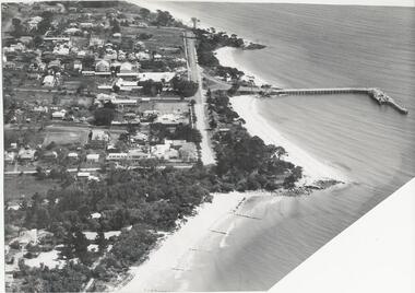
... Aerial photograph of Cowes, Foreshore and Jetty looking... john jenner bryant west Aerial photograph of Cowes, Foreshore ...One of a collection of over 400 Photographs in an Album commenced in 1960 and presented to the Phillip Island & Westernport Historical Society by the Shire of Phillip IslandAerial photograph of Cowes, Foreshore and Jetty looking west.local history, photography, photographs, cowes jetty foreshore, foreshore jetty cowes, aerial view of cowes phillip island, john jenner, bryant west -
 Phillip Island and District Historical Society Inc.
Photograph, Bryant West
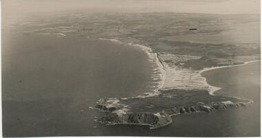
... Aerial Photograph of Cape Woolamai looking north-west.... Aerial Photograph of Cape Woolamai looking north-west. Photograph ...One of a collection of over 400 photographs in an album commenced in 1960 and presented to the Phillip Island & Westernport Historical Society by the Shire of Phillip Island.Aerial Photograph of Cape Woolamai looking north-west.local history, photography, photographs, coastline, cape woolamai, aerial view of cape woolamai, john jenner, bryant west -
 Phillip Island and District Historical Society Inc.
Photograph, Bryant West
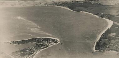
... Aerial Photograph of Phillip island Bridge and Cleeland's... west Aerial Photograph of Phillip island Bridge and Cleeland's ...One of a collection of over 400 photographs in an album commenced in 1960 and presented to the Phillip Island & Westernport Historical Society by the Shire of Phillip IslandAerial Photograph of Phillip island Bridge and Cleeland's Bight.local history, photography, photographs, civil engineering, bridges, phillip island bridge, coastline, bridge, phillip island, cleeland's bight, eastern passage phillip island, john jenner, bryant west -
 Glenelg Shire Council Cultural Collection
Photograph - Photograph - Borthwicks, 1960s
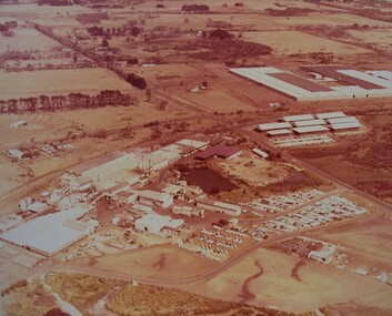
... Aerial photograph of Thomas Borthwick and Sons abattoir... stamp - not complete. Aerial photograph of Thomas Borthwick ...Glenelg Shire Council records.Aerial photograph of Thomas Borthwick and Sons abattoir, Portland.Back: Photographers stamp - not complete.borthwicks, abattoir, rural, industry -
Glenelg Shire Council Cultural Collection
Photograph, Photograph - Thomas Borthwick and Sons, n.d
... Black and white aerial photograph of Thomas Borthwick... Authority Archives Port of Portland Black and white aerial ...Port of Portland Authority Archivesport of portland -
 Orbost & District Historical Society
black and white photograph, February 1971
... This photograph is an aerial view of the township of Orbost...A black / white aerial photograph of a township... gippsland This photograph is an aerial view of the township ...This photograph is an aerial view of the township of Orbost taken by the Bairnsdale Advertiser newspaper. It was taken from the northern end of the town. The 1971 flood was the the worst flood on record. At Jarrahmond it was at least 11 metres and up to one and a half kilometres wide on the flats causing enormous damage to the flood plain. Records say that "The brown floodwater stain in Bass Strait could be seen from passing airliners." Considerable damage was done to railway infrastructure, roads and farms. More information from the APRIL, 2008 newsletter by John Phillips. (see orbosthistory.com.au)This is a pictorial record of a significant event in the history of Orbost,A black / white aerial photograph of a township with floodwaters in the background.on back - "Note main current through the lagoon 1971."orbost-floods-1971 bairnsdale-advertiser orbost-township -
Bendigo Historical Society Inc.
Photograph - AERIAL PHOTO OF BENDIGO
... Large black and white aerial photograph of the city... photograph of the city of Bendigo. Photograph AERIAL PHOTO OF BENDIGO ...Large black and white aerial photograph of the city of Bendigo.bendigo, streetscape, aerial view -
 Rutherglen Historical Society
Photograph - Aerial Images, c2000
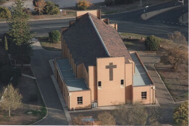
... Colour aerial photograph of the rear of the Catholic Church... Photograph Aerial Images ...View is of the rear of St Mary's Catholic Church, RutherglenColour aerial photograph of the rear of the Catholic Church in Rutherglenst marys church, church buildings, churches -
 Phillip Island and District Historical Society Inc.
Photograph, Bryant West
... aerial photograph, part of Cowes Township and beach... bryant west aerial photograph, part of Cowes Township and beach ...One of a collection of over 400 photographs in an album commenced in 1960 and presented to the Phillip Island & Westernport Historical Society by the Shire of Phillip Islandaerial photograph, part of Cowes Township and beach with Jetty in foregroundlocal history, photography, photographs, part cowes township - cowes beach and jetty, cowes township, beach, jetty, john jenner, bryant west -
 Phillip Island and District Historical Society Inc.
Photograph, Bryant West
... Aerial Photograph of Phillip Island Bridge - Newhaven... photographs in an album commenced in 1960 and presented to the Phillip ...One of a collection of over 400 photographs in an album commenced in 1960 and presented to the Phillip Island & Westernport Historical Society by the Shire of Phillip IslandAerial Photograph of Phillip Island Bridge - Newhaven to San Remo.local history, photography, photographs, civil engineering, bridges, bridge, newhaven, san remo, phillip island, coastline, suspention bridge phillip island, john jenner, bryant west -
 Phillip Island and District Historical Society Inc.
Photograph, Bryant West
... Aerial Photograph of Northern Coastline of Phillip Island... Aerial Photograph of Northern Coastline of Phillip Island ...One of a collection of over 400 photographs in an album commenced in 1960 and presented to the Phillip Island & Westernport Historical Society by the Shire of Phillip IslandAerial Photograph of Northern Coastline of Phillip Island with Rhyll in the foreground.local history, photography, photographs, northern coastline, phillip island, rhyll, coastline, cowes, john jenner, bryant west -
 Greensborough Historical Society
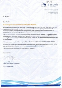
Letter, Restoring the natural beauty at Pioneer Reserve, 21/05/2019
... 2 p. letter, coloured aerial photograph on back page..., coloured aerial photograph on back page Restoring the natural ...Letter to residents, outlining plans to renovate Pioneer Reserve Greensborough by introducing native vegetation and returning it to a more natural state. This includes removing the toilets, picnic shelter and playground.2 p. letter, coloured aerial photograph on back pagepioneer reserve greensborough, banyule council