Showing 945 items
matching dams
-
 The Beechworth Burke Museum
Photograph, Unknown c.1930s
This image shows Bethanga Bridge, which was constructed between 1927 and 1930 in Albury, NSW. The bridge was a necessity due to the building of the Hume Dam (Wier), 1919-1936. Bethanga Bridge is a long, nine-span, riveted-steel, variable depth, Pratt Truss road bridge of nine principal spans of 82 metres and a total length of 752 metres over the flooded valley of the Murray River, now part of Hume Reservoir. Because of its unique location, over the waters of a dam with the border running down the centre of the body of water, the Bethanga bridge is the only built structure shared by both New South Wales and Victoria. It was built 1.6 kilometres upstream of the dam and in 1961 was raised 300mm, with a concrete deck replacing the original wooden deck. The State Rivers and Water Supply Commission of Victoria and the New South Wales Department of Public Works were responsible for the construction works for the Hume Weir under the River Murray Waters Agreement. It is apparent that a similar joint arrangement was made for the construction of the Bethanga Bridge as part of the Hume Weir works.This photograph of the Bethanga Bridge is of historical significance as it showcases the architectural skills of Percy Allen and Vincent Packer. Additionally, it reveals the environmental landscape of the 1920s-1930s, is linked to the Hume Dam and both New South Wales and Victorian heritage. Unmounted black and white rectangular photograph. Reverse: 1997.3196 84-20-3bethanga, bethanga bridge, hume dam, pratt truss, murray river, hume weir, transportation -
 Kiewa Valley Historical Society
Leaflet - Kiewa, Welcome to Kiewa
The State Electricity Commission of Victoria constructed the Kiewa Hydro Electric Scheme from 1938 to 1961. The Scheme included three power stations, dams, tunnels and was becoming a popular tourist destination with Falls Creek Ski field within its boundaries.This leaflet was published by the SECV to ensure all visitors to the Kiewa Hydro Electric Scheme were made aware of safety measures with regard to their driving and to bush fires. These were necessary as the area was unique with driving on mountainous roads, changeable and extreme weather and the threat of bush fires. The gatehouse existed during construction, when the SECV was in charge, as a restriction to entry to the Scheme for SECV workers and those with permission to enter. The SECV controlled the area so in case of accident, the SECV was the body to contact not eg. the police.Small white and green leaflet made from one sheet of glossy paper and folded in half. Front cover has the title in the middle, the SECV emblem at the centre top and across the bottom is a message to read the inside pages which are safety messages for driving and bush fires. The back cover has a RACV road map of Kiewa and its 'works' including the Gatehouse which was the entrance to the scheme.The map also has an insert of the main roads & nearby cities. state electricity commission of victoria; kiewa hydro electric scheme; gatehouse; safety rules; kiewa -
 Bendigo Historical Society Inc.
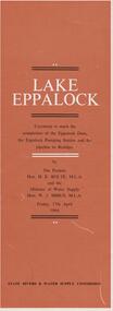
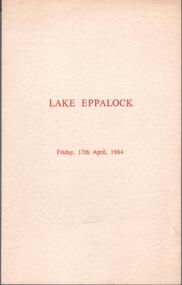
Document - LAKE EPPALOCK - OPENING CEREMONY PROGRAM
Folded document, 5 pages, produced to commemorate the opening of the Eppalock Dam, the Eppalock Pumping Station and the pipeline to Bendigo, by the Premier, Mr. H. Bolte, on 17th April, 1964. Brown cover, cream and black text. Illustrations show the cross section of the tunnel; a plan of the embankments and an overall plan of the weir.bendigo, waterworks, lake eppalock -
 Melbourne Legacy
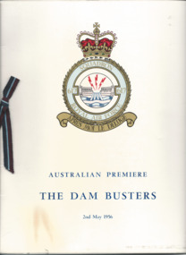
Programme - Document, programme, Australian Premiere. The Dam Busters, 1956
The Australian premiere of the film The Dam Busters was screened at the Windsor Theatre on 2nd of May 1956. It was attended by the Governor of Victoria, General Sir Dallas Brooks and his wife, Lady Brooks. Proceeds from the evening was donated to Melbourne Legacy and The Air Force Association.A record that Legacy used film screenings for a fundraising event. It was attended by the Governor who was patron of Legacy.Printed programme of a film premiere in aid of Legacy, cover has the 617 squadron emblem. Black and white photos and advertising inside. A glossy card cover and paper pages, with a decorative ribbon in the side. Also a ticket wallet with a Lancaster bomber image.fundraising, governor of victoria, gala performance -
 Bendigo Historical Society Inc.
Photograph - STATE RIVERS AND WATER SUPPLY COMMISSION, 1930 -1960
State Rivers and Water Supply Commission photographs. Donor unknown. Twelve packets of small B&W photographs covering construction of dams and channels and waterways in northern and central Victroia in 1930s, 1940s and 1950s. Some labelled. Pencil notes on back of some has faded. One B&W photo of Malmsbury Reservoir 1939. 22cm x 13.5 cm. One B&W photo of Kalimna Point. Castlemaine 1942. Name Mr King written on reverse. 28.5 cm x 11.5 cm. One brochure 'Tullaroop Dam' Official Opening. Friday 27 November 1959. Photos remain in paper packets. Unsorted as at 29/06/2023. -
 Bendigo Historical Society Inc.
Document - DRAINAGE PROBLEMS - MINERS SENSATIONAL EXPERIENCE AT THE VICTORIA QUARTZ
Handwritten notes from a Bendigo Advertiser report, Thursday June 16th 1910. Management had for some time been apprehensive that the flooding in the deep mines to the south would affect them. Lansell's 180 took the precaution of baling. On the Tuesday night the men at the Victoria Quartz had a sensational experience. The storage dam at 3324 ft level receives the overflow from the flooded mines to the south. The level connects with the 3310 level at the Big 180. The water flows uninterrupted into thestorage dam which has a capacity of about 270 tanks. The dam had been emptied on Tuesday morning and work continued until 10 pm that night. The platman noticed that the water was coming down the shaft in a regular torrent. They didn't take much notice as they thought it was a leakinig outlet valve on the ascending tank. At 11 pm the releiving shift came down the shaft and said that the dam at 3,324 ft must be overflowing. The velocity of the water pouring down the shaft increased and the men made a hurried exit from the bottom of the shaft which is down 310 ft from the 4.254 ft plat (a total depth of 4,564 ft). An inspection of the dam at the 3324 ft level found it to be overflowing. By morning (Wednesday) the shaft had filled, and the water rose to 7 ft in the plat at 4254 feet. Mining inspector hgave orders that men were not to go below the 3324 ft level. Baling continued without cessation at the Big 180 all day and could not lower the water. Drilling machines etc and a powerful air winch at the 4254 ft plat are under water. An inspection made of the 3100 ft level at the 180 mine where the workings are connected with the New Chum & Victoria showed that water was running strongly from that mine proving that the inrush was due to flooded water from the southern deep mines to the south. Document from Albert Richardson Collection of mining history. Document from Albert Richardson Collection of mining history.document, gold, drainage problems, new chum drainage scheme, miners sensational experience at the victoria quartz, bendigo advertiser 16/6/1910 page7, lansell's 180, big 180, new chum & victoria -
 Kiewa Valley Historical Society
Photos - A. Dartmouth Dam B.-E. Kiewa Valley
A. x3 colored photos of Dartmouth Dam during construction B. x5 black & white photos of Falls Creek and Kiewa Valley C. x7 black & white photos of groups of people D. x5 black & white photos and 3 colored photos of people in clubs E, x1 black & white photo -
Bendigo Historical Society Inc.
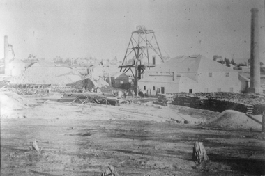
Photograph - FORTUNA COLLECTION: HUSTLERS AND ENERGETIC MINE
Black and white photograph of mine site. Metal poppet head in centre, engine room buildings on LH side. Brick chimney extreme left. Large mullock/sand heap on RH side. Mine dam in foreground, three geese floating in water. In front of poppet head, horse drawn wooden cartbendigo, mining, hercules and energetic mine -
Clunes Museum
Newspaper - NEWSPAPER CUTTING, THE ILLUSTRATED AUSTRALIAN NEWS
THE ABOVE PHOTOGRAPHS WERE TAKEN BY JOHN UNDERWOODPHOTOSTAT COPIES OF NEWS PAPER COLLECTION CUTTINGS FROM ILLUSTRATED AUSRALIAN NEWS. JUNE 17 th.1873. PHOTOSTAT COPY 1;RESERVOIR AND DAM OF CLUNES WATER SUPPLY. 2;SHAFT & SURFACE OF NEW NORTH CLUNES MINING CO. 3;UNDERGROUND WORKINGS OF NEW NORTH CLUNES MINING CO.17 JUNE 1878local history, document, newspaper cutting, mining -
 Stawell Historical Society Inc
Photograph, North Cross Reef Mine & Mining Scene 1870 -- B/W Photo & Coloured Painting
Mining Scene - North Cross Reef Co.B/W North Cross Reef with buildings, poppet heads, Tailings and wood stack with people. Two colour prints of North cross Reef. One at a different angle to B/W. Second taken further back with wood stacks, tailing dam fenced in beyond poppet heads buildings chimmney's smoking. stawell -
 Bendigo Historical Society Inc.
Photograph - St Paul's Church of England, Bendigo, 1935
Rae Alexander Anderson OAM (1903-1986) was connected to St Paul's Church and a pharmacist at the Bendigo Hospital. Rae was the organist and choir master of the parish church of St Paul, Bendigo, 1931 - 1965. Rae's son Stuart Anderson from the Balgownie Winery 1969-1999; had also been a pharmacist. Rae Anderson was a former President of the Royal Historical Society of Victoria, Bendigo Branch; now the Bendigo Historical Society. Rae died on the 8th. February, 1986 aged 82 years. He was a dedicated pharmacist; an outstanding musician; choir master and organist at St. Paul's Anglican Cathedral; a craftsman who loved to fashion things in wood and brass; interested tn the preservation of our heritage. Rae established "the Anderson Library" at the Society for reading and research.Eleven Photos of the St Paul's Church of England and an unknown dam. They were restored from a box of glass plate negatives found under a house in Mckenzie Street, Bendigo,.when it was sold. The photos are assumed to be taken by Rae Alexander Anderson and were processed through his pharmacy. One of the slides was marked 1935.bendigo history, sandhurst victoria, david anderson chemist, collins, dorman, holdsworth, rae anderson, st paul's church of england bendigo, bendigo hospital, stuart anderson -
 Bendigo Historical Society Inc.
Photograph - St Paul's Church of England, Bendigo, 1935
Rae Alexander Anderson OAM (1903-1986) was connected to St Paul's Church and a pharmacist at the Bendigo Hospital. Rae was the organist and choir master of the parish church of St Paul, Bendigo, 1931 - 1965. Rae's son Stuart Anderson from the Balgownie Winery 1969-1999; had also been a pharmacist. Rae Anderson was a former President of the Royal Historical Society of Victoria, Bendigo Branch; now the Bendigo Historical Society. Rae died on the 8th. February, 1986 aged 82 years. He was a dedicated pharmacist; an outstanding musician; choir master and organist at St. Paul's Anglican Cathedral; a craftsman who loved to fashion things in wood and brass; interested tn the preservation of our heritage. Rae established "the Anderson Library" at the Society for reading and research.Fifteen Photos of the St Paul's Church of England and an unknown dam. They were restored from a box of glass plate negatives found under a house in Mckenzie Street, Bendigo,.when it was sold. The photos are assumed to be taken by Rae Alexander Anderson and were processed through his pharmacy. One of the slides was marked 1935.bendigo history, sandhurst victoria, david anderson chemist, collins, dorman, holdsworth, rae anderson, st paul's church of england bendigo, bendigo hospital, stuart anderson -
Beechworth Honey Archive
Map- Albury
Map centred on Albury, showing Wodonga, Beechworth, Yackandandah and Chiltern. Topographic survey scale 1:100,000. Map is colour, printed on paper. Produced by Department of Minerals and EnergySheet 8225 (ed.1) series R. 652 Notes written on side regarding brigade boundaries, constructed access roads and fire trails, dams suitable for quick fill pump and areas 'fuel reduction burns Autumn 76'.map, albury, wodonga, beechworth, yackandandah, chiltern, paper, topographic, beechworth honey -
 Kiewa Valley Historical Society
Papers - Kiewa Hydro Electric Scheme, State Electricity Commission of Victoria / Kiewa Hydro Electric Project / Progress of the Undertaking, November 1953
The SECV constructed the KHES from 1939 to 1961 on the Bogong High Plains. It included work on Power Stations, Dams, Tunnels, Race-lines and transmission lines as well as camps, towns, roads, telecommunications and infra structure. These papers give an understanding of where the project was up to in late 1953. These papers give information on the KHES on the aspects of work, its progress and technical detail.3 foolscap pages, stapled in the top left hand corner. Each page has sub headings re the progress of the works being undertaken on the Kiewa Hydro Electric Scheme.state electricity commission of victoria; kiewa hydro electric scheme; power stations; dams; tunnels; bogong high plains -
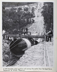 Melbourne Water
Photograph - Steel Pipeline, 1952
The Upper Yarra Reservoir supplies the Silvan Reservoir, which distributes water throughout the Melbourne metropolitan area. The dam was completed in 1957 and is a rolled earthfill and rockfill embankment. This photograph shows a 68" diameter steel pipeline that was to convey the water from the Upper Yarra Reservoir to the Silvan Reservoir.This photograph is significant as it provides a detailed insight into the Boards activity and construction of one of Melbourne's most important water supply systems. Furthermore, it is of historical importance to the history of Melbourne while it is representative of shaping Melbourne's environments, transforming and managing land and natural resources, and providing urban infrastructure and services. The photograph itself is aesthetically pleasing, through its depth of field and use of shape with an interesting composition. Black and white photographmmbw, melbourne metropolitan board of works, melbourne water, upper yarra reservoir, silvan reservoir, water, waterway, dam -
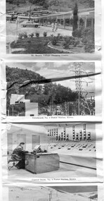 Kiewa Valley Historical Society
Postcard - Mt Beauty and the Kiewa Hydro Electric Scheme
SECV constructed the Kiewa Hydro Electric Scheme including the township of Mt Beauty. The area became a popular tourist destination.Tourism in the Kiewa Valley especially at Mt Beauty and the Bogong High Plains along with the Kiewa Hydro Electric Scheme became very popular and an important industry.Fold out b & w postcard with 12 photos back to back. All with a title. Kate 1950s 1. High Voltage Transmission Line, showing Mount Beauty Township 2. Clover Dam Reservoir, Kiewa 3. No. 3 Power Station, Kiewa 4. Generators, No. 3 Power Station 5. Turbines, No. 4 Power Station, Kiewa 6. junction Dam, Bogong 7. Mt Beauty Village Shopping Centre 8. Switchyard, No. 4 Power Station, Kiewa 9. Control Room, No. 4 Power Station, Kiewa 10. Winter Scene at Rocky Valley on the Bogong High Plains 11. Water Channel, Mt Bogong in Background 12. Mt Beauty Township, Kiewa Valleytransmission line, power station, generators, mt beauty, turbines, junction dam, switchyard, rocky valley, control room -
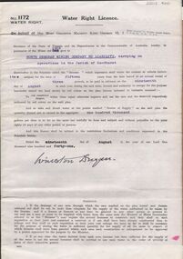 Bendigo Historical Society Inc.
Document - MCCOLL, RANKIN AND STANISTREET COLLECTION: WATER RIGHT LICENCE NORTH DEBORAH MINING COMPANY NO LIABILITY, 19th August, 1941
4 page document plus map, Water Right Licence No. 1172, between King George VI ( the Crown ) and North Deborah Mining Company No Liability, Parish of Sandhurst., dated 19th August 1941. "to take and divert water at the points marked 'source of supply' on the said plan the quantity thereof not to exceed in the aggregate one hundred thousand gallons per diem' Plan: 'Mining District of Bendigo No. 1172 W.R., County of Bendigo, Parish of Sandhurst. Plan has dam area coloured in red, with pipe line drawn in red, leading from Battery marked on lease 11145 across lease 9988 to dam. Streets marked: Adams Road, Honeybone Street, Griston Street. (Golden Square area)bendigo, mining, north deborah mining company, north deborah mining company, adams, honeybone, and griston streets. (golden square) -
 Bendigo Historical Society Inc.
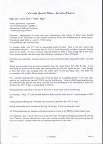
Programme - Aileen and John Ellison collection: Lake Eppalock dam completion
BHS CollectionProgram of the ceremony to mark the completion of the Eppalock dam and pumping station and the Eppalock-Bendigo pipeline. Grifay,17th April 1964. With the programme an invitation from the Chairman and Commissioners of the State Rivers and Water Supply Commission to Mr. John Ellison and Lady to attend the official ceremony to be performed by the Premier of Victoria, the Honorable H.E. Bolte MLAlake eppalock, eppalock dam -
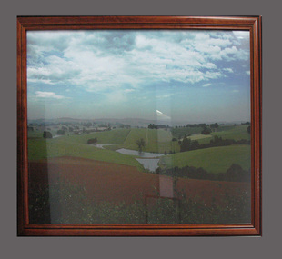 South Gippsland Shire Council
Photograph
Framed colour photograph featuring a landscape showing low hills, ploughed paddock in foreground and dams in centre. Brown timber frame. Note: Item approved for deaccession August 2023. SGSC will now follow deaccession procedures as outlined in the Arts and Civic Memorabilia Collection Policy - https://www.southgippsland.vic.gov.au/downloads/file/2763/arts_and_artefacts_collection_policy_c69. -
Bendigo Historical Society Inc.
Photograph - SOUTH NEW MOON MINE
Black and white photograph of a mining site with a dam. Wrtitten on back in pen 'South New Moon 1980ft', 'Approx. 1 mile north of Eaglehawk P.O., In 1908 175 men employed here'. Also written in blue ink '1 neg. 3 prints', '4 1/4 wide', 'A Richardson, 29 Harrison Street, Bendigo'.place, mining site, south new moon mine -
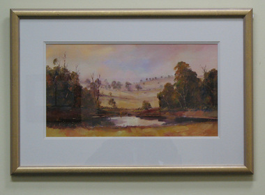 South Gippsland Shire Council
Painting, Watercolour, Late Afternoon
Framed watercolour titled "Late Afternoon" painted by Julie Lundgren Coulter. Features a country scene of trees, low hills, and a waterhole or dam. Painted in colours of browns, creams and yellows. Gold frame with triple cream card mount. On reverse is a name and address label of the artist & the text: "PEACE IS SEEKING A SUNSET & KNOWING WHO TO THANK""PEACE IS SEEKING A SUNSET & KNOWING WHO TO THANK" -
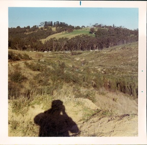 Southern Sherbrooke Historical Society Inc.
Photograph - Cardinia Creek area, Narre Warren East, prior to dam works
A set of four colour photos showing the area around where Cardinia Reservoir is now located. The photos show various views of the hillsides and valleys prior to the damming of Cardinia Creek. Each photo has 'Belgrave Cardinia Creek' handwritten on the back. They date from prior to May 1970. The set was donated to the society by David Howe. 'Belgrave Cardinia Creek' handwritten on the back of each photo. -
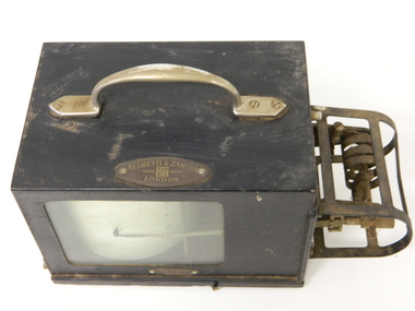 Kiewa Valley Historical Society
Barometer Anoroid, circa mid to late 1900's
This barometer was part the hydrology and forestry groups working within the SEC Vic Hydro Scheme from the initial appraisal review long before any construction began in the 1940's. The river flows and rainfall patterns had to be established before any construction of holding dams or tunneling could commence. This barometer is very relevant to the Kiewa Valley history because it presents the high degree of professional and technical information required at the time before implementing the "Scheme" upon the virgin alpine region and its effects upon the "natural" flows of the rivers within the Kiewa Valley. Time since the start of the project has verified the use of instruments such as this barometer and the information gained from its use that the success of any large impact upon a sensitive environment requires a thorough and systematic study before implementation. Weather records were kept of temperature, wet-bulb temperature, wind direction, speed and barometric pressures. To record barometric pressure a meter was devised with a clockwork mechanism which took one week to do a revolution. A chart was fitted to a drum and had an ink pen shaped like a little shovel. The shovel was filled with ink and was checked daily. To calibrate the barometer it was sent to the Melbourne General Post Office to be compared against the one there (at sea level). After calibration it was sent back to the Bogong Camp.On plaque on top side."NEGRETTI & ZAMBRA" underneath this and in smaller print "TRADE MARK" below this "LONDON" On the bottom and in small print "HOBART DUFFPty Ltd COLLINS HOUSE MELBOURNE C1"kiewa hydro electricity scheme, victorian state electricity commission, transformers, resistors, barometers -
![View on the Upper Buckland River / [by] Nicholas Caire, circa 1876](/media/collectors/550653872162f11fb04854aa/items/57830fc0d0cdd1176c450fda/item-media/57831013d0cdd1176c454bda/item-fit-380x285.jpg) Kew Historical Society Inc
Kew Historical Society IncPhotograph, Anglo-Australasian Photographic Company, View on the Upper Buckland River, c. 1876
Nicholas Caire was born on Guernsey in the Channel Islands in 1837. He arrived in Adelaide with his parents in about 1860. In 1867, following photographic journeys in Gippsland, he opened a studio in Adelaide. From 1870 to 1876 he lived and worked in Talbot in Central Victoria. In 1876 he purchased T. F. Chuck's studios in the Royal Arcade Melbourne. In 1885, following the introduction of dry plate photography, he began a series of landscape series, which were commercially successful. As a photographer, he travelled extensively through Victoria, photographing places few of his contemporaries had previously seen. He died in 1918. Reference: Jack Cato, 'Caire, Nicholas John (1837–1918)', Australian Dictionary of Biography.An original, rare photograph from the series 'Views of Victoria: General Series' by the photographer, Nicholas Caire (1837-1918). The series of 60 photographs that comprise the series was issued c. 1876 and reinforced a neo-Romantic view of the Australian landscape to which a growing nationalist movement would respond. Nicholas Caire was active as a photographer in Australia from 1858 until his death in 1918. His vision of the Australian bush and pioneer life had a counterpart in the works of Henry Lawson and other nationalist poets, authors and painters.‘View on the upper Buckland River’ : Views of Victoria (General Series) No.46 : Albumen silver photograph | Photo on card with Title and Description on reverse | Mounted 24 x 30 cm; Photo 12 x 17 cm.On Reverse: ‘The Buckland River is situated near the western extremity of the Australian Alps, and forms one of the sources of the Ovens River. Its watercourse is very shallow, except in flood time. Our illustration is taken on the upper portion of the River, near Reeve’s dam.’nicholas caire (1837-1918), buckland river (vic), landscape photography - victoria -
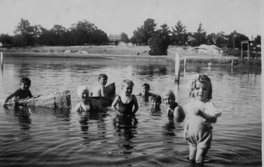 Linton and District Historical Society Inc
Photograph, Children in Edinburgh Dam, Linton, 1939, 1939
Small black and white photograph of eight children in a body of water. Two of the children are sitting in homemade canoes.Reverse: " EDINBURGH? DAM / LINTON about 1939 / ALAN Mc / RONALD Mc / VIC McGRATH? / JOY Mc EILEEN HADDON / BRIAN Mc / RUTH Mc BOATS MADE FROM / SHEETS OF GALV IRON / BELTED FLAT & / TURNED OVER ".edinburgh dam swimming pool, mccorkell family, vic mcgrath? -
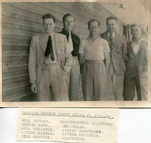 Kiewa Valley Historical Society
Set of 4 photographs of SECV Clerical staff, 1940 - 1941
The Kiewa Hydroelectric Scheme is the largest hydro-electric scheme in Victoria and the second largest in mainland Australia after the Snowy Mountains Scheme. The scheme is situated in the Australian Alps in north-eastern Victoria about 350 km from Melbourne and is wholly owned by AGL Energy. The scheme was originally constructed between 1938 and 1961 by the State Electricity Commission of Victoria although it was privatised in the 1990s. The scheme was originally developed solely for electricity generation, unlike the Snowy Mountains Scheme, which was also intended to direct water west of the Snowy Mountains for purposes of irrigation. From 1937 to 1944 the construction of dams at Pretty Valley, Rocky Valley and the Junction Dam were undertaken requiring large numbers of planning and support staff to see the projects successfully completed. Planning and support staff were the backbone of the successful completion of the Kiewa Valley Hydro Electric Scheme and contributed significantly to the development of the Kiewa Valley area. Many descendants of the men in the photographs still living and working in the local areaSet of 4 black and white photographs of SECV clerical staff – Circa 1940/1941Typed on note glued to back of each photo, Numbers handwritten in blue ink in top left hand corner 1. DRAWING OFFICE STAFF KIEWA C. 1940-41 Bob Morgan – Construction Draftsman; Duncan Kerr – Draftsman; Rob Hollands – Survey Draftsman; Arthur Keeble – Office Engineer; Bill Godfrey – Draftsman 2. CLERICAL OFFICE STAFF KIEWA Peter Harnetty – Clerical; Bert Connors – Clerical; John Martin – Stores Clerical; Ken Calder – Head Storekeeper; Bill black – Construction Records 3. CLERICAL OFFICE STAFF KIEWA Jack Norman, Herb Kendall, Jack Bray – Stores Clerical; Ken Calder – Head Storekeeper; Jim Swain, George Milner – Stores Clerical; Jim Gleeson – Storekeeper; John Martin – Stores Clerical 4. OFFICE STAFF KIEWA C. 1940 Don Faulkner – Cadet Engineer; Tas Davies – Survey Draftsman; Bob Morgan – Construction Darftsman; R.J. Martin, Arthur Keeble – Office Engineers; Rob Hollands – Survey Draftsman; Jack Wollard – Head Surveyor; Harry Wilson – Plan Officer. Printing Plans Handwritten in red ink on back of photo 4 – Refer Rob Hollands secv clerical staff -
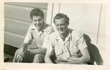 Kiewa Valley Historical Society
Photograph of Ray Esdaile and unidentified man, 1950
The Kiewa Hydroelectric Scheme is the largest hydro-electric scheme in Victoria and the second largest in mainland Australia after the Snowy Mountains Scheme. The scheme is situated in the Australian Alps in north-eastern Victoria about 350 km from Melbourne and is wholly owned by AGL Energy. The scheme was originally constructed between 1938 and 1961 by the State Electricity Commission of Victoria although it was privatised in the 1990s. The scheme was originally developed solely for electricity generation, unlike the Snowy Mountains Scheme, which was also intended to direct water west of the Snowy Mountains for purposes of irrigation. From 1937 to 1944 the construction of dams at Pretty Valley, Rocky Valley and the Junction Dam were undertaken requiring large numbers of planning and support staff to see the projects successfully completed. Planning and support staff were the backbone of the successful completion of the Kiewa Valley Hydro Electric Scheme and contributed significantly to the development of the Kiewa Valley area. Many descendants of the original SECV workers are still living and working in the local areaBlack and white photograph of 2 men, one identified as Ray Esdaile at Mt Beauty SEC Camp in 1950Handwritten on back of photograph in blue ink: Ray Esdaile and self (unidentified) 1950 Mt Beauty Camp SECray esdaile, secv, mt beauty -
 Bendigo Historical Society Inc.
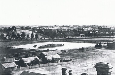
Photograph - LANDSCAPE VIEW OF BENDIGO
Black and white photograph. In foreground, roof and chimneys. Row of 3 small weatherboard houses with verandah, picket fences. 1 small and 1 larger building behind. Lake or dam with small island centre, stone brick wall with lookout tower at corner ( Bendigo gaol ) at right centre distanc,e large building. Benevolent Asylum. Many other buildings in distance. James Lerk 11.2.2000 ' view from the Corporate High School, Benevolent Asylum in centre' Unknown BHS member 5.11.1999 ' lower dam ( site of present tennis courts, Park Road, pumped out C 1926' Written on back of photo 'Bendigo Victoria 1860's, Sandhurst North view 100 miles north from Melbourne. C. Nettleton, Victorian Views'C. Nettleton ?place, landscape view, bendigo -
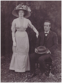 Linton and District Historical Society Inc
Photograph, Mr. and Mrs. James Carlyle Bennett
Wedding photograph of Lillian Ball and James Carlyle Bennett, who married in Adelaide in 1910. Lillian Ball was a daughter of Oscar Ball and his wife Elizabeth, née Mitchell. James Mitchell Carlyle Bennett was not related to the Bennett family which ran the butcher's shop. He was mine manager at Dawson's Dam.Black and white copy of original photograph showing a seated man in dark suit, holding hat. A lady standing next to man wearing dress, gloves and large floral hat in an outside setting.james mitchell carlyle bennett, lyle bennett, lillian bennett, lillian ball -
 Ballarat Heritage Services
digital photographs, Lisa Gervasoni, Pre-Olympic Swimming Pool at Kilmore, c2012, c2010-2017
There are many reports of early swimming holes in 19th Century Victoria. Between the period 1895 - 1920, most rural Councils were under pressure to provide more formalised bathing arrangements. Often this occurred through the building of wooden enclosures in rivers, the damming of creeks, the construction of lakes, or the utilisation of old pits for the purpose.Colour photograph of the site of the former Kilmore Pool, now a reservoir on the Kilmore Golf Club. swimming pool, sport, swimming, pre olympic, natural, lake, kilmore, pre-olympic