Showing 10684 items
matching east melbourne
-
 Flagstaff Hill Maritime Museum and Village
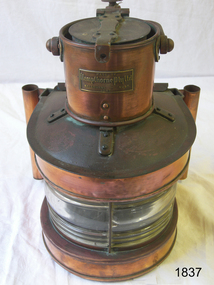
Functional object - Marine Lamp, Kempthorne Pty Ltd, 1941
... in East Malvern, Melbourne Victoria in 1931 by brothers Selwyn... as Coffey Lanterns in East Malvern, Melbourne Victoria in 1931 ...Kempthorne Lighting Pty. was established as Coffey Lanterns in East Malvern, Melbourne Victoria in 1931 by brothers Selwyn and Owen Coffey. They manufactured lighting fixtures and fittings including oil lamps for marine use as well as for the domestic market. In early 1936 two other brothers, Erle and Terence had joined the company which was renamed Kempthorne Lantern Works Pty., Ltd. In 1946 Kempthorne joined with a small design team who had developed a domestic fan to form the subsidiary, Mistral fans. The company previously known as Kempthorne Holding Ltd was listed on the stock exchange in 1968. In 1977-1979 Kempthorne Mistral Ltd. Was a holding company comprising of Kempthorne Lighting Pty., Ltd. & Mistral Fans Pty., Ltd. An early Australian made marine lamp by a significant manufacturer that is still in business today making electrical equipment. The item is an important artefact that was made by an early Australian business that started in the 1930s. Over the years this company has demonstrated many innovations to the manufacturer of electrical items. Marine copper Lamp, round with brass makers lozenge and rounded hollow lugs set on either side of the lamp. Heavy metal handle with brass locking pin. Lid with catch on top. Made by Kempthorne Pty Ltd Melb. 1941flagstaff hill, warrnambool, shipwrecked-coast, flagstaff-hill, flagstaff-hill-maritime-museum, maritime-museum, shipwreck-coast, flagstaff-hill-maritime-village, lamp, copper ship lamp, ship lamp, kempthorne pty ltd -
 Eltham District Historical Society Inc
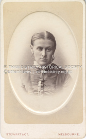
Photograph, Stewart & Co, Possibly Jane Shillinglaw, c.1878
... Street East Melbourne from 1874 through 1905. The photo... Street East Melbourne from 1874 through 1905. The photo ...Jane Shillinglaw was born 14 Jun 1846. She had a a son, Joseph Shillinglaw in 1863 and a daughter Jane Davidson in 1870 prior to her marriage to William James Sommerville in 1887. Jane's younger sister Catherine Shillinglaw was born 13 Nov 1852 at Coburg, Victoria. She married Edward Henry Bottle in 1897 This photo shows fashion and hairstyles typical of the later 1870s. Photographer Stewart & Co operated from various addresses in Bourke Street East Melbourne from 1874 through 1905. The photo is estimated to have been taken c.1878 which would make Jane 32 years of age and Catherine 26 years. There is another photo of who is believed to be Catherine Shillinglaw with Edward Henry Bottle. There are visual differences with the eyes so it is presumed this photo is of Jane. A duplicate photo is contained in Album 2 (05664) Stewart & Co operated from 217 Bourke St., East from 1871 to 1876 and from 217-219 from 1877 to 1889. Other locations included 42, 284 and 286. Overall, they operated in Melbourne from 1871 through at least 1910 though Carte-de-Visite photos were superseded by 1890. CARTE-DE-VISITE (cdv) 1857-1890 Cartes-de-visite (cdv's) are the most common form of photograph from the nineteenth century, generally measuring two and a half inches by four and an eighth inches (6.3 x 10.5 cm) when mounted, sepia toned, mounted on a card which was generally printed with the photographer's name and address on the back or beneath the portrait. - Frost, Lenore; Dating Family Photos 1850-1920; Valiant Press Pty. Ltd., Berwick, Victoria 1991marg ball collection, shillinglaw family photo album 1, 1871-1890, 1878, jane shillinglaw (1846-1893), jane sommerville (nee shillinglaw 1846-1893), shillinglaw family photo album 2, stewart & co photographers melbourne, unknown -
 Kew Historical Society Inc
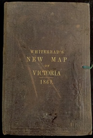
Map, Whitehead's Map of Victoria, With Alphabetical Key, 1869, 1869
... . E.. WHITEHEAD and CO, Publishers, 67 Collins-street east...., Puolishers, 67 Collins-street East, Melbourne". In the same edition ...When E. Whitehead's New Map of Victoria was released in 1869, an advertisement in the Bendigo Advertiser (16 July 1869) noted that: "This beautifully engraved Map has been revised and brought down to the present time; and, with the Alphabetical Key, is the most complete and the cheapest Map ever published; Price, 6d plain; 1s colored; 2s 6d in case; on linen, post free, 2d extra. E.. WHITEHEAD and CO, Publishers, 67 Collins-street east." The following year, 1870, Whitehead's promoted the edition in the Portland Guardian and Normanby General Advertiser (3 January 1870), advising that: "WHITEHEAD'S NEW MAP OF VICTORIA, 1869 ... is corrected to the latest date, and around is arranged an Alphabetical Key, with Post Towns and Money Order Olffices marked. The Map being divided into squares and numbered, by reference to the Key any place can be found immediately. Price Is beautifully colored, or mounted on linen in case, 2s 6d. Post free, 2d extra, in Victoria. B. Whitehead and C0., Puolishers, 67 Collins-street East, Melbourne". In the same edition of the Portland Advertiser, they also promoted their business generally, saying: "E WHITEHEAD and Co., Stationers, Engravers, Lithographers, 67 Collins street East, execute every description of Lithographic PRINTING, BILL-HEADS. NOTE Headings. Business Dies Engraved and Embossed on Envelopes &c. ARMS, MONOGRAMS, AND CRESTS Engraved and Embossed in Colour, superior to any other house in the Colony. Specimens, post free, 2d. Lithographers, &c, to H.R.H. the Duke of Edinburgh, and Die-inkers and Embossers to His Excellency Sir J. H. T. Manners-Sutton, K C.B. Orders executed for the Trade". Whitehead’s New Map of Victoria 1869 is is an important record of region created towards the end of the Victorian Gold Rush (1851-1869). In addition to its historical significance, this is a rare map, of which the only known copies in Australian public collections are those held at the National Library of Australia, the State Library of Victoria, State Library of New South Wales and the University of Queensland Library.Map of Victoria with gold mining areas, notes on topography, transport routes. Relief shown by hachures. List of towns with distance from Melbourne in map margin. [Melbourne] : Printed & Published by ... E Whitehead & Co ... 67 Collins Street East, 1869 1 map : col., mounted on linen ; 38.4 x 55.4 cm, folded to 18 x 12 cm.Cover "WHITEHEAD'S NEW MAP OF VICTORIA 1869"maps - victoria - 1860s, e whitehead's new map of victoria 1869, whitehead's map of victoria with alphabetical key 1869, cartography, gold rush -
 Kew Historical Society Inc
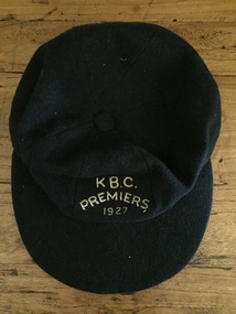
Uniform, K.B.C. Premiers 1927
... , J. Marshall and C. Robinson (ex Hawthorn-East Melbourne..., J. Marshall and C. Robinson (ex Hawthorn-East Melbourne ...The Victorian Baseball League was established in 1889 with the following clubs - MCC, Metropolitan, Richmond, Richmond Cricketers, Kew, Geelong, Fitzroy, The Age, Carlton, Coburg. MCC defeated Metropolitan for the first Premiership. By 1897 Kew had built up to six teams, but went into recess about the turn of the century. They reformed c.1906 and did not resume until 1926 under Captain/Coach Frank Littlefield. I think he was ex Hawthorn Baseball and/or Cricket club(s). They won the D Grade Premiership of 1926 and/or 1927 playing out of Victoria Park at 12 noon, and as a curtain raiser to either Kew or Kew District or East Kew Football Club and after World War 2, North Kew which had now joined Kew as a tenant. Team members were H.L. Barclay (ex Richmond), A. Brierley (ex Collingwood), H. Ely (ex Essendon), Frank Littlefield, J. Marshall and C. Robinson (ex Hawthorn-East Melbourne Cricket Club). In 1926, the KBC played against Caulfield, Fairfield, Fitzroy, Ivanhoe, Northcote, Prahran, University, Williamstown, YMCA. In 1927, Preston replaced Fairfield. A third team was formed post WW2 which played at Willsmere Park. The Reserves followed to Willsmere Park in 1963 and the Seniors in c.1970. Kew Council moved the club to a sub-standard Stradbroke Park No 2 Oval for the 1976 season and this proved to be the last for the club. Melbourne Baseball Club moved in for two seasons, but also moved when improvements to No 2 Oval were not made. They then moved to Macleay Park in a share arrangement with North Balwyn BC. Research: Ian Job, 2015A premiership cap awarded to Christopher Robinson of the Kew Baseball Club in 1927.Navy blue peaked baseball cap, embroidered in gold thread with K B.C. Premiers 1927sports uniforms, caps, premiership caps, baseball, -
 Marysville & District Historical Society
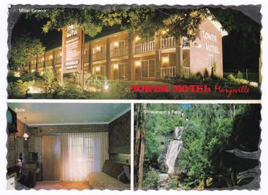
Postcard (item) - Colour postcard, Nucolorvue Productions Pty. Ltd, TOWER MOTEL Marysville, Unknown
... ) 63 3225 New luxury Motel, 100 km north/ east of Melbourne.../ east of Melbourne in the heart of/ the big timber country ...A colour postcard from the Tower Motel in Marysville. The postcard was published by Nucolorvue as a souvenir of Marysville. The Tower Motel was one of the few buildings in Marysville that survived the 2009 Black Saturday bushfires.A colour postcard from the Tower Motel in Marysville. The postcard was published by Nucolorvue as a souvenir of Marysville.A/ NU-COLOR-VUE/ OF/ AUSTRALIA PLACE/ STAMP/ HERE POST CARD Product of Australia RP66 NUCOLORVUE PRODUCTIONS PTY. LTD./ COPYRIGHT TOWER MOTEL/ Murchison St., Marysville, Vic./ Phone (059) 63 3225 New luxury Motel, 100 km north/ east of Melbourne in the heart of/ the big timber country - just a/ short drive from the magnificent/ floodlit Steavenson's Falls - the/ tallest in Victoria. Units equipped with all modern/ facilities, including colour T.V. and/ air conditioning.marysville, victoria, australia, tower motel, accommodation, postcard, souvenir, nucolorvue productions pty. ltd., 2009 black saturday bushfires -
 Marysville & District Historical Society
Postcard (item) - Colour postcard, Nucolorvue Productions Pty. Ltd, TOWER MOTEL Marysville, Unknown
... ) 63 3225 New luxury Motel, 100 km north/ east of Melbourne.../ east of Melbourne in the heart of/ the big timber country ...A colour postcard from the Tower Motel in Marysville. The postcard was published by Nucolorvue as a souvenir of Marysville. The Tower Motel was one of the few buildings in Marysville that survived the 2009 Black Saturday bushfires.A colour postcard from the Tower Motel in Marysville. The postcard was published by Nucolorvue as a souvenir of Marysville.A/ NU-COLOR-VUE/ OF/ AUSTRALIA PLACE/ STAMP/ HERE POST CARD Product of Australia RP66 NUCOLORVUE PRODUCTIONS PTY. LTD./ COPYRIGHT TOWER MOTEL/ Murchison St., Marysville, Vic./ Phone (059) 63 3225 New luxury Motel, 100 km north/ east of Melbourne in the heart of/ the big timber country - just a/ short drive from the magnificent/ floodlit Steavenson's Falls - the/ tallest in Victoria. Units equipped with all modern/ facilities, including colour T.V. and/ air conditioning.marysville, victoria, australia, tower motel, accommodation, postcard, souvenir, nucolorvue productions pty. ltd., 2009 black saturday bushfires -
 Bendigo Historical Society Inc.
Newspaper - WEEKLY TIMES SPORT, 1928
... North Melbourne, East Albury, Horsham, Dimboola, Echuca, Nhill... teams include North Melbourne, East Albury, Horsham, Dimboola ...Brown paper folder containing cuttings from Weekly Times showing football teams and cricket teams. Football teams include North Melbourne, East Albury, Horsham, Dimboola, Echuca, Nhill, Preston, Port Melbourne, Essendon, Wangaratta, Preston, Benalla, Hamilton, Kyabram, Echuca, Shepparton, Castlemaine, Sandhurst, Albury, St. Patrick's, Maryborough, Brunswick, Wimmera, Gippsland, St. Kilda, Melbourne Grammar, South Melbourne and Hawthorn. Cricket teams include the English Cricket Team and the Australian Team (1928).newspaper, football -
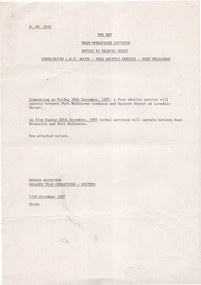
 Melbourne Tram Museum
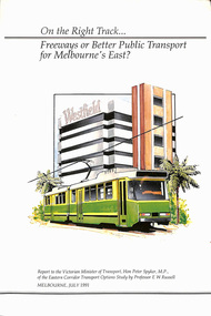
Document - Report, Professor E. W. Russell, "On the right track .. Freeways of Better Public Transport for Melbourne's East?", Jul. 1991
... for Melbourne's East?", to the Victorian Minister for Transport Hon. Peter... for Melbourne's East?", to the Victorian Minister for Transport Hon. Peter ...Report - 120 pages + cover perfect bound - titled "On the right track .. Freeways of Better Public Transport for Melbourne's East?", to the Victorian Minister for Transport Hon. Peter Spyker by Professor E. W. Russell, dated July 1991. Has a table of contents. Report looks at the options for transport to the Doncaster area, freeways, light rail or tram or heavy rail, considers options for the extension of routes 48 and 72 (along Burke Road), buses, tram line from Shoppingtown to Box Hill. Includes illustrations and maps.trams, tramways, public transport, doncaster, box hill, new tramway, route 48, route 72 -
 Orbost & District Historical Society
Invitation, 1969
... about 380 kilometres east of Melbourne, the state capital... about 380 kilometres east of Melbourne, the state capital ...The current building was opened on Friday 28th February 1969 by the Premier of Victoria, The Hon. Sir Henry E. Bolte, K.C.M.G., M.P. The Shire of Orbost was a local government area about 380 kilometres east of Melbourne, the state capital of Victoria, Australia. The shire covered an area of 9,347 square kilometres and existed from 1892 until 1994. Originally, Orbost was part of the Bairnsdale Road District which was created on 30 April 1867. Splitting away as part of the Shire of Tambo in 1882, Orbost was first incorporated as a shire in its own right as the Shire of Croajingolong on 30 May 1892. It received its present name on 17 February 1893. On 3 January 1913 part of its western riding was annexed to Tambo as its Cunninghame Riding. Local governments play an important role in the lives of citizens in Australia. Local government authorities exist to provide services and amenities to local communities, and are also responsible for regulating and providing services for land and property in their district. This item is representative of a time when Orbost had its own Shire Council. A stapled program and invitation to the official opening of the new Orbost Shire Council Municipal Offices. A light blue card with the Orbost Shire Council insignia and gold print on front. The invitation is addressed to the secretary of Orbost Historical Society Judith Walcott.handwritten in blue pen - "Judith G Walcott"orbost-shire-council -
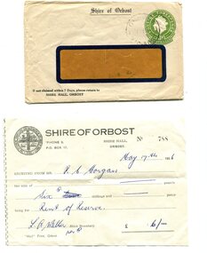 Orbost & District Historical Society
envelope and receipt, Snowy River Mail as "Mail" Print, May 17 1956
... was a local government area about 380 kilometres east of Melbourne... was a local government area about 380 kilometres east of Melbourne ...This receipt was issued to R. C. Morgan of Orbost. on May 17, 1956. It was for rent of reserve for six shillings. It was issued by the Orbost Shire Council. The Shire of Orbost was a local government area about 380 kilometres east of Melbourne, the state capital of Victoria, Australia. The shire covered an area of 9,347 square kilometres and existed from 1892 until 1994. Originally, Orbost was part of the Bairnsdale Road District which was created on 30 April 1867. Splitting away as part of the Shire of Tambo in 1882, Orbost was first incorporated as a shire in its own right as the Shire of Croajingolong on 30 May 1892. It received its present name on 17 February 1893. On 3 January 1913 part of its western riding was annexed to Tambo as its Cunninghame Riding. Local governments play an important role in the lives of citizens in Australia. Local government authorities exist to provide services and amenities to local communities, and are also responsible for regulating and providing services for land and property in their district. This item is representative of a time when Orbost had its own Shire Council. A widow - faced envelope with a green threepence stamp top right corner. At the top is "Shire of Orbost". Bottom right is "If not claimed within 7 Days please return to SHIRE HALL, ORBOST".There is a receipt to R.C. Morgan for 6/- being for the "rent of reserve" and signed by L.A. Walker. It has the Orbost Shire logo in the top left corner.orbost-shire-council morgan-r.c. -
 St Kilda Historical Society
Ephemera - Ticket, Picnic to Park Orchards, 1936
... east of Melbourne that was created in 1925 on land used... is a residential suburb 23km north east of Melbourne that was created ...Ticket to picnic at Park Orchards on 21 December 1936, organised by the St Kilda Unemployed Organisation with the support of the St Kilda City Council, Mayor (Cr Alfred Levy), Archie Michaelis MLA, and 'other well-known gentlemen'. The ticket appears to have been perforated to allow vouchers, printed on the back (for bus, dinner, toys, stockings, ice cream and tea) to be separated and used. Park Orchards is a residential suburb 23km north east of Melbourne that was created in 1925 on land used for orchards when timber merchants Australis Sharp and John Taylor launched the Park Orchards Country Club estate. Buyers were not attracted to the estate, and for many years all that existed were a clubhouse and various sporting facilities. It gained popularity when demand for housing surged in the 1950s.Grey/green coloured card, printed in blue on both sides and with 5 evenly spaced lines of perforations across the width.st kilda unemployed organisation, st kilda council -
 Mentone Grammar School
J Allan Anderson - one of the founders of Mentone Grammar School
... M. Allingham. Moving to East Kew, Melbourne, in 1917, where... M. Allingham. Moving to East Kew, Melbourne, in 1917, where ...J Allan Anderson graduated from the University of Melbourne in 1902. The following year he joined a law practice in the Victorian country centre of Stawell, where he met and married Ethel M. Allingham. Moving to East Kew, Melbourne, in 1917, where his son attended Trinity Grammar School. By March 1921 the family had exchanged their annual summer holidays at Mentone for permanent residence when they moved into Captain Dawson's former home, 'Riviera' off Mentone Parade. Disappointed with standards at this son's new local school and now living in a fast-growing town and district, in 1922, on a train journey to his office in the City, 46-year-old solicitor J.A. Anderson came up with the idea to form a new grammar school for boys in Mentone. -
 The Beechworth Burke Museum
Geological specimen - Slice Dendrites on Sandstone, Unknown
... in the Lilydale district, east of Melbourne. Sandstones are made of tiny... in the Lilydale district, east of Melbourne. Sandstones are made of tiny ...Dendrites are deposits of black minerals, typically manganese oxides that precipitated from water seeping through fractures in fine-grain rocks like a sandstone or limestone. Dendrites are much less regular than plant fossils and lacks vein structures. The manganese cryztallizes through the process called 'supercooling'. Some samples of dendrites occur in volcanic rocks in the Lilydale district, east of Melbourne. Sandstones are made of tiny sand grains that may have been deposited in the sea and later formed together. Most sandstones are made of quartz which are chemically-resistant minerals. This particular specimen was donated by Alfred Selwyn in 1868 as part of the Geological Survey of Victoria. It is connected to the original 1875 catalogue on Geological Specimen with number 189 'Quartz Crystals_Quartz Crystals (two are polished)'Dendrites on sandstones This specimen is an important contribution to the geological history of Victoria, as well as its links to the 1868 Geological Survey of Victoria. This specimen is part of larger collection of significant geological specimens in the Burke Museum that was collected from around the world between 1868-1880. A large percentage of these specimens were collection as part of the Geological Survey of Victoria 1852-1974. The Geological Survey of Victoria was an organisation founded in response to the Victorian gold rush to explore the geological and mineral resources and to record a detailed map of the state. It was headed by British geologist, Alfred Richard Cecil Selwyn (1824-1902), who was responsible for issuing over 60 geological maps during his 17 years as director. These maps were all hand-drawn and coloured and became the benchmark for accuracy for geological mapping. Collecting geological specimens was an important part of mapping and understanding the scientific makeup of the earth. Many of these specimens were sent to research and collecting organisations across Australia, including the Burke Museum, to educate and encourage further study. A hand-sized slice of light brown sandstone with dendrites formed from crystallized manganese oxide.Existing label: Not sure what / 'Slica dondrites' / means. / Sample is sandstone and original label / identifies it as from / the Grampians near Stawell. / C. Willman / 15/4/21 Other label: [illegible] / stone [ illegible] / from Grampians Stawell / 1894 /geological specimen, geology, geology collection, burke museum, beechworth, dendrites, sandstones, quartz, lilydale district, geological survey of victoria, grampians, victoria rocks, minerals, rocks, manganese oxides, alfred selwyn -
 Eltham District Historical Society Inc
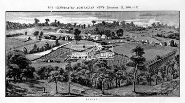
Photograph, Samuel Calvert, Eltham, The Illustrated Australian News, December 26, 1884, p212, 1884
... on the Yarra Flats road, about 14 miles east north east of Melbourne... on the Yarra Flats road, about 14 miles east north east of Melbourne ...A description in the newspaper near the illustration (page 210) reads as follows: "Eltham is a pretty little township on the Yarra Flats road, about 14 miles east north east of Melbourne, from which place there is communication by way of Heidelberg. It has a population of nearly 400 inhabitants, but in addition it is the centre of a large district extending over about 203 square miles, having a population of 2344. The land in the district is mostly used for grazing purposes, although as a rule the small farms grow a good deal of wheat, oats and other agricultural produce. A large quantity of fruit, especially raspberries and strawberries, is also produced, the rich alluvial flats along the creek upon which the township is situated being very well adapted for that purpose. Gold has also been found in the vicinity of the township, but not in remunerative quantities". This photo forms part of a collection of photographs gathered by the Shire of Eltham for their centenary project book,"Pioneers and Painters: 100 years of the Shire of Eltham" by Alan Marshall (1971). The collection of over 500 images is held in partnership between Eltham District Historical Society and Yarra Plenty Regional Library (Eltham Library) and is now formally known as 'The Shire of Eltham Pioneers Photograph Collection.' It is significant in being the first community sourced collection representing the places and people of the Shire's first one hundred years.Digital imageshire of eltham pioneers photograph collection, eltham, illustrated australian news -
 Melbourne Tram Museum
Ephemera - Timetable/s, Public Transport Victoria (PTV), Set of 25 digital timetables - Yarra Trams, 2016
... - East Malvern - and via St Kilda Beach Route 5 - Melbourne... - East Malvern - and via St Kilda Beach Route 5 - Melbourne ...Set of 25 digital timetables generally applicable 2016 to 13/4/2017. Similar timetables ran during 13/4/2017 and 1/5/2017 over the Easter Holiday period up to when Route 58 (from route 8 and route 55) introduced and route 6 modified - see Reg item 2212 for details. List major stops only. All downloaded from the PTV website 9-4-17 as pdf files. Image files are htd2211iRx - x being the route number. Route 1 - East Coburg - South Melbourne Beach Route 3 and 3A - Melbourne University - East Malvern - and via St Kilda Beach Route 5 - Melbourne University - Malvern Route 6 - Melbourne University - Glen Iris Route 8 - Moreland - Toorak Route 11 - West Preston - Victoria Harbour Docklands Route 12 - Victoria Gardens - St Kilda Route 16 - Melbourne University - Kew Via St Kilda Route 19 - North Coburg - Flinders St Route 30 - St Vincent's Plaza - Etihad Stadium Docklands Route 35 - City Circle Route 48 - North Balwyn - Victoria Harbour Docklands Route 55 - West Coburg - Domain Interchange Route 57 - West Maribyrnong - Flinders St Route 59 - Airport West - Flinders St Route 64 - East Brighton - Melbourne University Route 67 - Carnegie - Melbourne University Route 70 - Wattle Park - Waterfront City Docklands Route 72 - Camberwell - Melbourne University Route 75 - Vermont South - Etihad Stadium Docklands Route 78 - North Richmond - Balaclava via Prahran Route 82 - Footscray - Moonee Ponds Route 86 - Bundoora RMIT - Waterfront City Docklands Route 96 - East Brunswick - St Kilda Beach Route 109 - Box Hill - Port Melbournetrams, tramways, timetables, yarra trams, route 1, route 3, route 5, route 6, route 8, route 11, route 12, route 16, route 19, route 30, route 35, route 48, route 55, route 57, route 59, route 64, route 67, route 70, route 72, route 75, route 78, route 82, route 86, route 96, route 109 -
 Melbourne Tram Museum
Ephemera - Timetable/s, Public Transport Victoria (PTV), Set of 24 digital timetables - Yarra trams, 2016
... 1 - East Coburg - South Melbourne Beach Route 3 and 3A... 1 - East Coburg - South Melbourne Beach Route 3 and 3A ...Set of 24 digital timetables generally applicable 1/4/2017 to end 2017 Introduced when Route 58 (from route 8 and route 55) amalgamated and route 6 modified - see Reg item 2212 for details. All downloaded from the PTV website 9-4-17 as pdf files, except for routes 6 and 58 which had not been published as of that date. Timetables list major stops. Routes 6 and 58 files added 6-6-2017. Image files are htd2213iRx - x being the route number. Route 1 - East Coburg - South Melbourne Beach Route 3 and 3A - Melbourne University - East Malvern - and via St Kilda Beach Route 5 - Melbourne University - Malvern Route 6 - Moreland - Glen Iris Route 11 - West Preston - Victoria Harbour Docklands Route 12 - Victoria Gardens - St Kilda Route 16 - Melbourne University - Kew Via St Kilda Route 19 - North Coburg - Flinders St Route 30 - St Vincent's Plaza - Etihad Stadium Docklands Route 35 - City Circle Route 48 - North Balwyn - Victoria Harbour Docklands Route 57 - West Maribyrnong - Flinders St Route 58 - Toorak - West Coburg via William St. Route 59 - Airport West - Flinders St Route 64 - East Brighton - Melbourne University Route 67 - Carnegie - Melbourne University Route 70 - Wattle Park - Waterfront City Docklands Route 72 - Camberwell - Melbourne University Route 75 - Vermont South - Etihad Stadium Docklands Route 78 - North Richmond - Balaclava via Prahran Route 82 - Footscray - Moonee Ponds Route 86 - Bundoora RMIT - Waterfront City Docklands Route 96 - East Brunswick - St Kilda Beach Route 109 - Box Hill - Port Melbournetrams, tramways, timetables, yarra trams, route 1, route 3, route 5, route 6, route 11, route 12, route 16, route 19, route 30, route 35, route 48, route 57, route 58, route 59, route 64, route 67, route 70, route 72, route 75, route 78, route 82, route 86, route 96, route 109 -
 Melbourne Tram Museum
Sign, Melbourne & Metropolitan Tramways Board (MMTB), "Fitzroy Football Ground", "Sth Melb Football Ground", 1950's
... of the type that could hang on the front of a Melbourne tram car...Melbourne Tram Museum 8 Wallen Road Hawthorn melbourne ...Sign, painted onto a MMTB auxiliary destination board of the type that could hang on the front of a Melbourne tram car with the words "Fitzroy Football Ground" and "Sth Melb Football Ground" Black letters on a yellow background. The bottom right hand corner of the Sth Melbourne face has the letters "E.P." indicating the depot that it belonged to - East Preston. South Melbourne Football Ground Metal sign, fitted with metal hanging brackets, riveted to sign on both sides. Manufactured by rolling the outer edges over a 4mm diameter steel rod.trams, tramways, football, fitzroy, south melbourne, signs, auxiliary board -
 Melbourne Legacy
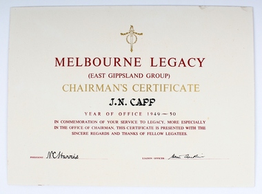
Certificate, Chairman's Certificate, Circa 1950
... as Chairman of Melbourne Legacy (East Gippsland Group) from 1949-50... of Melbourne Legacy (East Gippsland Group) from 1949-50. Signed ...Certificate acknowledging J.N. (John Nelson) Capp as Chairman of Melbourne Legacy (East Gippsland Group) from 1949-50. Signed by President (N.C. Harris) and Liaison Officer (signature not legible). Certificate reads “In commemoration of your service to Legacy, more especially in the office of Chairman, this certificate is presented with the sincere regards and thanks of fellow Legatees.”Record of Legatee Capp’s service to Melbourne LegacyWhite paper certificate with red, gold and black type. Two signatures. Glued to cardboardnelson capp, east gippsland group -
 Orbost & District Historical Society
brochures, Snowy River Mail as "Mail" Print, Shire of Orbost Information Brochure, December 1970
... kilometres east of Melbourne, the state capital of Victoria... kilometres east of Melbourne, the state capital of Victoria ...The Shire of Orbost was a local government area about 380 kilometres east of Melbourne, the state capital of Victoria, Australia. The shire covered an area of 9,347 square kilometres ), and existed from 1892 until 1994. Originally, Orbost was part of the Bairnsdale Road District which was created on 30 April 1867. Splitting away as part of the Shire of Tambo in 1882, Orbost was first incorporated as a shire in its own right as the Shire of Croajingolong on 30 May 1892. It received its present name on 17 February 1893. On 3 January 1913 part of its western riding was annexed to Tambo as its Cunninghame Riding. On 2 December 1994, the Shire was abolished, and merged with City and Shire of Bairnsdale, Shire of Tambo, most of Shire of Omeo and the Boole Boole Peninsula from Shire of Rosedale into the Shire of East Gippsland This is a useful research tool.Two copies of a triple fold paper brochure. It is titled"Shire of Orbost Information Brochure" in black print. It contains the names of councillors, staff, the work program and budget.shire-of-orbost -
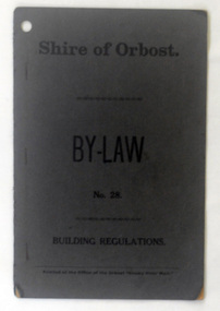 Orbost & District Historical Society
booklet, Snowy River Mail, Shire of Orbost By Laws No 28, 1920's
... kilometres east of Melbourne, the state capital of Victoria... kilometres east of Melbourne, the state capital of Victoria ...This booklet contains by law No 28 pertaining to building regulations. The Shire of Orbost was a local government area about 380 kilometres east of Melbourne, the state capital of Victoria, Australia. The shire covered an area of 9,347 square kilometres ), and existed from 1892 until 1994. Originally, Orbost was part of the Bairnsdale Road District which was created on 30 April 1867. Splitting away as part of the Shire of Tambo in 1882, Orbost was first incorporated as a shire in its own right as the Shire of Croajingolong on 30 May 1892. It received its present name on 17 February 1893. On 3 January 1913 part of its western riding was annexed to Tambo as its Cunninghame Riding. On 2 December 1994, the Shire was abolished, and merged with City and Shire of Bairnsdale, Shire of Tambo, most of Shire of Omeo and the Boole Boole Peninsula from Shire of Rosedale into the Shire of East Gippsland. This item is a useful research tool.A dark grey, stapled, paper covered booklet with title "Shire of Orbost By Law No 28" in black print. -
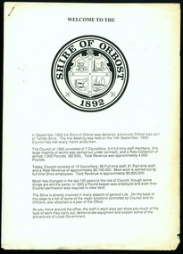 Orbost & District Historical Society
information sheet, Welcome to the Shire of Orbost, 1992
... kilometres east of Melbourne. The shire covered an area of 9,347... about 380 kilometres east of Melbourne. The shire covered ...This was possibly produced for an open day in the centenary year. The Shire of Orbost was a local government area about 380 kilometres east of Melbourne. The shire covered an area of 9,347 square kilometres and existed from 1892 until 1994. Originally, Orbost was part of the Bairnsdale Road District which was created on 30 April 1867. Splitting away as part of the Shire of Tambo in 1882, Orbost was first incorporated as a shire in its own right as the Shire of Croajingolong on 30 May 1892. It received its present name on 17 February 1893. On 3 January 1913 part of its western riding was annexed to Tambo as its Cunninghame Riding. On 2 December 1994, the Shire was abolished, and merged with City and Shire of Bairnsdale, Shire of Tambo, most of the Shire of Omeo and the Boole Boole Peninsula from Shire of Rosedale into the Shire of East Gippsland. This is a useful reference tool.Two stapled pages of printed information. On the front page is the logo of Orbost Shire Council. There is information on the role of the Shire Councillors for 1992/93. It has a map of the council building.orbost-shire-council -
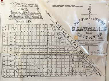 City of Moorabbin Historical Society (Operating the Box Cottage Museum)
Document, photocopy of Plan of Beaumaris 1853, c1960
... , 19 km south-east from Melbourne's central business district..., 19 km south-east from Melbourne's central business district ...Beaumaris includes two early estates in the parish of Moorabbin developed by Josiah Holloway from 1852. Named Beaumaris Town and Beaumaris Estate (after the pastoral run in the area and ultimately after Beaumaris in Wales), the lots comprising them were marketed by Mr Holloway's suggesting that the railway was imminent and a canal would be built. The township developed slowly, a Post Office opened on 1 March 1868, but was replaced next month by Gipsy Village office (now Sandringham) In 1862 Beaumaris was one of the early settler communities within the boundaries of the Moorabbin District Roads Board , the region’s first local government authority. Beaumaris is a suburb in Melbourne, Victoria, Australia, 19 km south-east from Melbourne's central business district. .Since the Amalgamation of Councils 1994 the local government area is the City of Bayside which includes Brighton. A Photocopy of the Plan of Beaumaris 1853 A3moorabbin, county of bourke, brighton, beaumaris, pioneers, early settlers. market gardeners, cheltenham, king. john, holloway josiah, whorral charles, arthur’s seat road, nepean highway, morabbin district roads board, sandringham, mordialloc, mentone -
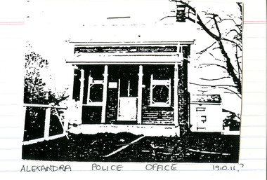 Victoria Police Museum
Police Stations (Alexandra)
... in Victoria, Australia and 130 kilometres north east of Melbourne... in Victoria, Australia and 130 kilometres north east of Melbourne ...Alexandra is a regional centre in the Shire of Murrindindi in Victoria, Australia and 130 kilometres north east of Melbourne. Alexandra Police Station opened in the Benalla Police District on 8 May 1867 in Bon Street, on the north side near Grant Street. When the station opened it was staffed by one Senior Constable; one 1st Constable (Mounted); one Foot Constable. The original building was a nine-roomed brick building with an iron roof on land measuring 84' x 97’. The house included a wash-house, pantry, bathroom, office, one W.C., stabling for three horses, a lock-up with two rooms and a single man's room. It closed in June 1977 and was replaced by a new police station which opened on 16 June 1977 in Bon Street, on land adjacent to the old police station. For a list of Officers in Charge 1871 to 1943 contact Victoria Police Museum1 black and white photo and 3 colour photospolice stations; alexandra police station -
 Melbourne Tram Museum
Postcard, Rose Stereograph Co, "Melbourne from the Air", early 1940s
... the Air", Photo looking east over Melbourne with the Melbourne...", Photo looking east over Melbourne with the Melbourne skyline ...Rose Series postcard No. P 622, titled ""Melbourne from the Air", Photo looking east over Melbourne with the Melbourne skyline, railway yards, St Kilda Road, Yarra River and Princes Bridge in the view. Three trams can be seen in the view in St Kilda Road. The building in the middle bottom of the photo is the recently completed Australian Provincial Assurance (APA) Assocation Limited Head Office on the south east corner of Collins and Queen Streets. This 1889 building was refaced and the tower added in 1928-1929. The adding of three additional floors to the Bank of Australasia building, 1875-1876, is well in hand 1929-1931 on the north west corner of Queen and Collins Streets. On the south east corner of the corner of Collins and Market Streets, the new Australian Mutual Provident (AMP) Society Head Office is reaching full height, also constructed 1929-1931. Yields information about an aerial view of Melbourne C1930Postcard - printed real photograph with Rose Stereograph Co. name on the rear.tramways, trams, aerial views, melbourne, collins st. -
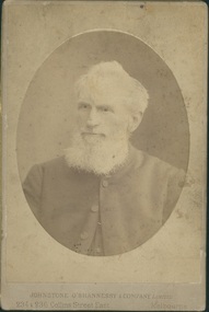
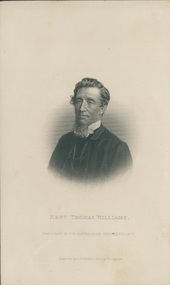 Uniting Church Archives - Synod of Victoria
Engraving from photograph, Revd Thomas Williams, Undated c.1873
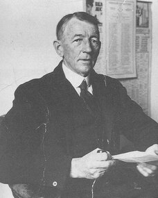
... , Creswick, Colac, Ballarat East, Castlemaine and Melbourne South. He... Street Malvern East melbourne Rev Thomas Williams (1815 - 1891 ...Rev Thomas Williams (1815 - 1891) went to Lakeba, Fiji as a missionary in 1839. In 1843 he went to Somosomo, and in 1848 to Bua. When his health failed, he was sent back to the colonies, and did circuit work in Adelaide 1854 - 1856. In 1857 he was transferred to Victoria, where he was stationed in Melbourne, Brighton, Creswick, Colac, Ballarat East, Castlemaine and Melbourne South. He became a Supernumerary in 1878. He was elected president of the 18th and last Australasian Conference held in Sydney in 1873.B & W head and shoulders image of the Rev. Thomas Williams.Revd Thomas Williams President of the Australasian Conference 1873.rev thomas williams, fiji, missionary, lakeba, somosomo, bua, adelaide, president of the australasian conference -
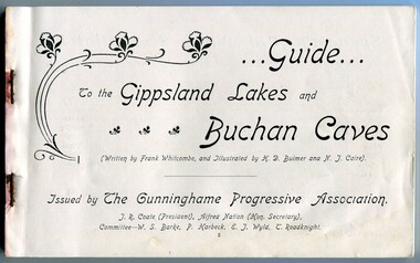 Orbost & District Historical Society
Book, The Cunninghame Progressive Association, Guide to Buchan Caves & the Gippsland Lakes, c.1900-1910
... Nowa, Sale, and Bairnsdale. An early tourist promotion for East... Nowa, Sale, and Bairnsdale. An early tourist promotion for East ...This booklet was issued as a tourist advertising/promotion for the Gippsland Lakes and Buchan Caves. It was most likely printed in the early 20th Century. This promotion also includes associated areas such as Lake Tyers, Cunninghame (Lakes Entrance), Nowa Nowa, Sale, and Bairnsdale. An early tourist promotion for East Gippsland, focussing on Melbourne tourists travelling to Sale or Bairnsdale by train, and then by steamer or coach. An example of an early tourism promotion.A booklet of 103 pages, printed in b/w. The cover is a dk. red paper with gold print, quite fragile. The book contains b/w photographs, advertisements, time tables for trains and steamers travelling through the Gippsland Lakes from Sale to Cunninghame (eg. SS JCD), also a map of the steamer route. ...Guide... To the Gippsland Lakes and Buchan Caves (Written by Frank Whitcombe, and Illustrated by H D Bulmer and N J Caire). Issued by The Cunninghame Progressive Association. J R Coate (President), Alfred Nation (Hon. Secretary), Committee - W S Barke, P Harbeck, E J Wyld, T Roadknightbuchan caves, gippsland lakes, ss j c d, tourism -
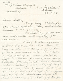 Mission to Seafarers Victoria
Letter - Correspondence, Letter to Lillie from Ted
... Letter addressed to Miss L Duncan, 11 Paxton St, East... Paxton St, East Malvern, Melbourne, Australia from Ted in three ...The "letters to Lillie" show the international nature of the Mission to Seafarers. They are an important display of the handwriting style of the time, revealing courting attempts and give us an insight into life in 1925.Lillie Duncan was a member of the Harbour Lights Guild and this letter forms part of a collection of letters sent to her by different seafarers.Letter addressed to Miss L Duncan, 11 Paxton St, East Malvern, Melbourne, Australia from Ted in three parts: Envelope (0112.1) Letter page 1 (0112.2) Letter page 2 (0112.3). Both the envelope and the letter are creamy yellow in colour with black curly writing. Both sides of each page of the letter are written on. The first page of the letter begins with "Write. c/o Graham Trading Co. Calcutta. cancelled" placed at the top left of the page and "S.S. Matheran Calcutta 28-8-27" placed at the top right of the page. The first line begins with "Dear Lillie, Very many thanks for...". The reverse side of the first page starts "...thickness of solid steel fracturing is it not?". The second page begins with "...be home two months..." and the reverse side concludes with "Hope if you write to me you will use the address below, that will find me. 'Lyndale 117 Greenway Road, Taunton, Somerset, England".The envelope is torn across the top for access to its contents. The address has been typed in black ink. It has one red stamp to the top right hand corner of the envelope with the text "Ceylon 9c". There is also a black ink stamp in the form of several horizontal lines running from top left to top right of the envelope with "Colombo" written in the middle.ss matheran, calcutta, ss mangalore, colombo, ted, lillie duncan, lhlg -
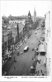 Melbourne Tram Museum
Postcard, Rose Stereograph Co, "'The Block' - Collins Melbourne ", c1910
... ' - Collins Melbourne " looking east from Elizabeth Street. Has... Melbourne " looking east from Elizabeth Street. Has at least nine ...Rose Series postcard No. P 955, titled "'The Block' - Collins Melbourne " looking east from Elizabeth Street. Has at least nine cable trams in the view, along with horse drawn vehicles and motor cars. Has signs for James Thelwell ladies Tailor and Lafayette. The verandah on the south side of Collins Street is part of the "Centreway Arcade" and building constructed in 1911-12.Yields information about Collins St, c1914.Postcard - printed real photograph with Rose Stereograph Co. name on the rear.Has the Ken Magor stamp on the rear.trams, tramways, cable trams, collins st, melbourne town hall -
 Melbourne Tram Museum
Document - Notice, The Met, "North/South LRT route - free shuttle Service - Port Melbourne", 11/12/1987
... Port Melbourne and to Lonsdale St at Spencer St, following... and Saturday 19/12. Services between East Brunswick and Port Melbourne ...Notice to crews about a free shuttle tram service between Port Melbourne and to Lonsdale St at Spencer St, following the opening of the Port Melbourne line. Applicable for Friday 18/12/1987 and Saturday 19/12. Services between East Brunswick and Port Melbourne commenced on Sunday 20/12/1987. Signed by Dennis Griffiths Manger tram operations western.Yields information about the opening of the Port Melbourne line in 1987.A4 sheet - Notice No. D 5042tramcars, tramways, port melbourne, opening, new tramway, free tram -
 Uniting Church Archives - Synod of Victoria
Photograph, Undated c.1880
... , Melbourne East, Geelong, St. Kilda, Sandhurst, Hawthorn. Died 21... Street Malvern East melbourne Rev. William P. Wells (1826 - 1895 ...Rev. William P. Wells (1826 - 1895) Born Marton, Lincolnshire 1826. Probationer of the English Methodist Conference 1850. Appointed to a mission circuit in Newfoundland. Returned to England in 1852. Sent to Melbourne in 1854. President of the South Australian Conference and later President of the Victorian Conference. President of Prince Alfred College, South Australia. Started the Methodist Building and Loans Fund. Codified Methodist laws and regulations. Served as minister in Castlemaine, Melbourne West, Melbourne East, Geelong, St. Kilda, Sandhurst, Hawthorn. Died 21 December 1895.Sepia toned head and shoulders oval inset studio portrait of the Rev. William P Wells.rev. william p. wells, president of conference, prince alfred college, methodist, minister, building and loans fund