Showing 480 items
matching eltham-greensborough road
-
 Eltham District Historical Society Inc
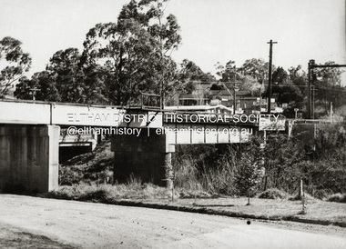
Photograph - Black and White Print, Railway Bridge across Plenty River near Railway Road, Briar Hill, Vic, c. August 1977
Para Road bridge across Plenty River can be seen behind railway bridge.Black and white photographinfrastructure, bridge, greensborough, para road bridge, railway road bridge, shire of eltham infrastructure -
 Eltham District Historical Society Inc
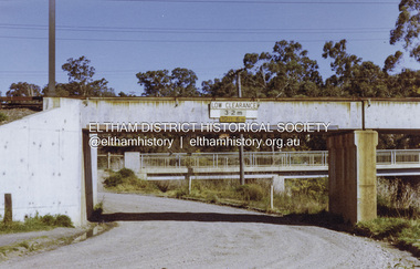
Photograph - Colour Print, Railway Bridge across Plenty River near Railway Road, Briar Hill, Vic, c. August 1977
Para Road bridge across Plenty River can be seen behind railway bridge.Colour photographinfrastructure, bridge, greensborough, para road bridge, railway road bridge, shire of eltham infrastructure -
 Eltham District Historical Society Inc
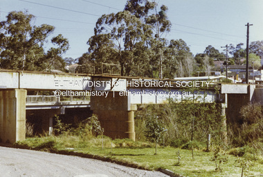
Photograph - Colour Print, Railway Bridge across Plenty River near Railway Road, Briar Hill, Vic, c. August 1977
Para Road bridge across Plenty River can be seen behind railway bridge.Colour photographinfrastructure, bridge, greensborough, para road bridge, railway road bridge, shire of eltham infrastructure -
 Eltham District Historical Society Inc
Document - Folder, Sibbel Builders Pty Ltd
Sibbel Builders was a partnership of brothers Herman and Martin Sibbel; they lived in Eltham. Their daughters Wilhelmina McCarroll and Fleur Sibbel founded the furniture design company Zuster. Contents Manningham Heritage Study report, 68-70 Olympus Drive, Lower Templestowe, 8 July 2005, pp260-261: Background of Sibbel Builders Printout: Research information, Sibbel Builders Pty Ltd. Details of Wilhelmina McCarroll and Fleur Sibbel and furniture design company Zuster. Newspaper advertisement: Diamond Valley Leader, 25 June 2008. 19 Spring Street, Greensborough, a Sibbel Classic house [reverse: 43 Para Road, Montmorency].Newspaper clippings, A4 photocopies, etcwilhelmina mccarroll, fleur sibbel, zuster furniture design, martin sibbel, herman sibbel, sibbel builders pty ltd, 19 spring street greensborough, 43 para road montmorency -
Eltham District Historical Society Inc
Document - Folder, Ross, Andrew
Andrew Ross was schoolmaster at Kangaroo Ground from 1851; he was later also post-master, lay preacher, and electoral registrar Contents Copy Latrobe Manuscript Collection index card: Ross, Andrew. Extracts from Latrobe Library Manuscript Collection, Box 2584: Bound book "Autobiography - Andrew Ross". Photocopies pages 295 and 367 re Kangaroo Ground. Newspaper clippings, A4 photocopies, etcandrew ross, kangaroo ground, robert ross, margaret ross nee mitchelson, alexander mitchelson, alison wight, andromache ship, scots school melboourne, kangaroo post office, caledonia gold rush, eltham road board, mountain diggings, william brimmer, william mclaughlin, t johnston of greensborough, evelyn observer newspaper -
 Eltham District Historical Society Inc
Photograph - Digital Photograph, Alan King, Nillumbik Shire Offices, Greensborough, 30 March 2008
Nillumbik Shire Council transferred to the former Diamond Valley Shire Offices in Greensborough after municipal restructuing. The offices became the official Nillumbik Shire Council Offices on 16 October 1995. The former Shire of Diamond Valley Civic Centre or Shire Office building was officially opened on 26th February 1972. Archtiects were A.K. Lines, McFarlane & Marshall and it was built by L.U. Simon Pty Ltd, The Diamond Valley Shire had been created in 1964 from part of the City of Heidelberg. On December 15, 1994 the Shire of Nillumbik was established. Under the Council amalgamations imposed by the Kennett government, the Shire of Eltham, Shire of Diamond Valley and City of Heidelberg ceased to exist with the establishment of Nillumbik Shire Council and the City of Banyule.The new Nillumbik shire surrended the west riding from Eltham to Banyule but in place gained parts of the former Diamond Valley Shire which itself had been created in 1964 from parts of the City of Heidelberg. Three unelected and non-local Commissioners were put in place by the government bringing democracy into question by many members of the local community. The Commissioners determined to abandon the former Shire of Eltham offices located in Main Road, Eltham and in turn occupy the former Shire of Diamond Valley offices located at the boundary of the new shire with Banyule, in Civic Drive, Greensborough. In July 1996 the Commissioners sold the former Eltham Shire Offices and had them bulldozed leading to many years of communiity protest over the process and future development applications. The site has remained vacant ever since. Published: Nillumbik Now and Then / Marguerite Marshall 2008; photographs Alan King with Marguerite Marshall.; p43 It was the need for roads that led to this district’s first council. In 1853 a committee was formed to improve the rough roads, some in Kangaroo Ground being almost impassable in winter.1 The committee fundraised by voluntary levies and grants to improve in particular, the main road between Kangaroo Ground and the Plenty River. From this committee arose the Eltham District Road Board, in 1856, which was the precursor to the Eltham Shire Council. The Board’s first chairman was Kangaroo Ground farmer, John Barr. Secretary was the former committee’s secretary, Andrew Ross, Kangaroo Ground’s first school teacher, and founder of the district newspaper, The Evelyn Observer.2 Most of the board’s income came from a toll-house north of the Lower Plenty Bridge, which funded such projects as a road from Kangaroo Ground to the Caledonia Diggings. In 1871 the Shire of Eltham was proclaimed, with its boundaries the same as those of the Road Board, and Councillor A Donaldson of Kangaroo Ground was the first president. Eltham was at the southern tip of the shire, which extended north to Kinglake and east beyond Yarra Glen. In 1878, part of Kinglake was added to the shire, while the area east of Watts River, near Healesville was removed. In 1912, then again in 1958, the shire was further reduced. Yarra Glen, Steels Creek, Tarrawarra, parts of Healesville and Christmas Hills, were transferred to the Shire of Healesville. In 1972 a smaller area, at Kinglake, was transferred to the Shire of Yea, leaving 277 square kilometres in the Eltham Shire. Perhaps no other Victorian municipality has had so many meeting places. Although from 1858 to 1904, the council convened at the office in the home of Secretary Charles Wingrove, the board, and later the council, also met at other more central locations.3 The board moved from the Fountain of Friendship Hotel to the Eltham Courthouse, to the Kangaroo Ground schoolhouse. It then met at the Kangaroo Ground Hotel, which some considered put it in danger of interruptions by people ‘the worse for liquor’.4 In 1885 the council met at the hall on Mr J Donaldson’s land at Kangaroo Ground. After Wingrove’s retirement, the council rented space at the Kangaroo Ground General Store and Post Office. Then, in 1917, the council bought the former office of The Evelyn Observer, after its printing works transferred to Hurstbridge. In 1934, fire destroyed the shire office, which was temporarily relocated to the Kangaroo Ground home of Shire Secretary, Mr P J McMahon. In 1941, the shire office moved to a new building (which included a public hall) in Eltham, at the corner of Arthur Street and Main Road, where the Eltham Village Shopping Centre was eventually built. Growth required new offices, which opened in 1965, on the former Shillinglaw property in Main Road.5 In 1994, as part of municipal restructuring under the Jeff Kennett Liberal Government, most of the Eltham Shire formed part of the new Shire of Nillumbik. It joined with the north section of the Diamond Valley Shire and parts of the Healesville and Whittlesea municipalities. The Diamond Valley Shire had been created in 1964, from part of the City of Heidelberg. Turbulence followed Nillumbik Shire’s formation. Under the Commissioners the council transferred to the former Diamond Valley Shire offices in Greensborough, and the Eltham council offices were demolished. In March 1997 the first five-member Nillumbik Council was elected. But, in October 1998, the government suspended the council and appointed an administrator . Early in 1999, shire residents voted to increase councillors to nine: comprising five ward councillors and four shire-wide councillors. Elections were held in March 1999. Then, before the March 2002 elections, nine new wards were created.6 In 2008 these were reduced to seven. Today [2008] the council governs a varied population of more than 60,000 people living in townships and on bush properties in the green wedge.This collection of almost 130 photos about places and people within the Shire of Nillumbik, an urban and rural municipality in Melbourne's north, contributes to an understanding of the history of the Shire. Published in 2008 immediately prior to the Black Saturday bushfires of February 7, 2009, it documents sites that were impacted, and in some cases destroyed by the fires. It includes photographs taken especially for the publication, creating a unique time capsule representing the Shire in the early 21st century. It remains the most recent comprehenesive publication devoted to the Shire's history connecting local residents to the past. nillumbik now and then (marshall-king) collection, greensborough, nillumbik shire council offices, civic drive -
 Eltham District Historical Society Inc
Photograph - Digital Photograph, Alan King, Eltham Railway Trestle Bridge, 28 December 2007
Covered under National Trust of Australia (Victoria) State Significance and Heritage Overlay, Nillumbik Planning Scheme. Published: Nillumbik Now and Then / Marguerite Marshall 2008; photographs Alan King with Marguerite Marshall.; p103 The Eltham railway trestle bridge is the only one of its kind still regularly used in Melbourne’s metropolitan railway network. Opened in 1902, it is also one of Victoria’s very few timber rail bridges that still carries trains.1 The bridge is part of the railway line extension from Heidelberg - extended to Hurstbridge in 1912. This extension resulted in one of the greatest social changes experienced in Eltham Shire, as it considerably lessened its isolation attracting tourists, artists and suburban commuters particularly after World War Two.2 The bridge has been classified by the National Trust as historically, scientifically, aesthetically and socially significant at state level. But this has not always been recognised, and in 1977, locals fought to save it from destruction. The Victorian Railways proposed to replace the bridge with an earth embankment and large culverts to avoid maintenance problems and fire. This was rejected by the Eltham Council who protested that the bridge helped maintain the area’s rural character, historic link and beauty, as well as avoiding possible serious flooding on the flood plain if a culvert was blocked. The bridge stands as part of a National Trust classified landscape which includes the Alistair Knox Park, named after the local conservationist and architect who helped to make Eltham famous for its mud-brick houses. The landscape includes tall and spreading manna gums and candlebarks, and the historic Shillinglaw Cottage. Artist Walter Withers, one of the Heidelberg School of painters, painted the bridge early in the 20th century. The 38 span single-track railway bridge over creek and road has 34 timber-beam spans and four steel-joist spans, supported by four-pile timber piers and timber abutments. It has almost 200m of timber deck. All of the timbers have been replaced over the years, but the only change to the bridge’s character was the addition of pylons and wiring for electric trains in 1923. A petition for a railway to the shire was first made in 1883. A large deputation of local citizens to the Commissioner of Railways proposed a route passing through Alphington to midway between Greensborough and Eltham up the Diamond Creek valley towards Queenstown and Kinglake. As a result the Princes Bridge-Heidelberg Railway was opened in 1888. From 1888 locals demanded a railway extension. Kangaroo Ground farmers in particular, led by Shire Councillor and Member for Evelyn, Ewen Cameron, said it would assist local farmers and orchardists send their produce to the Melbourne market. In 1890, before the severe economic Depression, an extension of the line to Hurst’s Bridge (now Hurstbridge) was included in a new Railways Bill. The parliamentary delegations were regaled with a banquet at Hurst’s barn and entertained by the Diamond Creek Brass Band, but the extension was abandoned when the Depression struck in 1892-1893. The extension of the railway to Eltham, completed in 1902, was one of the few built in those hard times. That is why the Eltham timber-trestle railway bridge is a rare example of a broad-gauge rail bridge constructed between 1893 and 1910. At the opening, despite persistent drizzle, 300 children waving flags and banners were among the large crowd welcoming the first train, carrying official dignitaries, to Eltham. It had taken 24 years to bring the railway to Eltham. From then Eltham became a popular destination for outings. Mr Orford of Eltham recalled that after the railway came to Eltham ‘the craze for picnics on weekends and holidays began…. During the wattle season, wattle trains came to Eltham frequently. The visitors roamed the creek pulling great armfuls of wattle blossom to take back with them to Melbourne’.3 In 1926 the railway line was electrified as part of the metropolitan rail network. But the Victorian Railways decided not to complete the formerly planned Diamond Valley Railway to Queenstown (now St Andrews) and Kinglake.This collection of almost 130 photos about places and people within the Shire of Nillumbik, an urban and rural municipality in Melbourne's north, contributes to an understanding of the history of the Shire. Published in 2008 immediately prior to the Black Saturday bushfires of February 7, 2009, it documents sites that were impacted, and in some cases destroyed by the fires. It includes photographs taken especially for the publication, creating a unique time capsule representing the Shire in the early 21st century. It remains the most recent comprehenesive publication devoted to the Shire's history connecting local residents to the past. nillumbik now and then (marshall-king) collection, eltham railway trestle bridge, eltham trestle bridge -
 Eltham District Historical Society Inc
Photograph - Digital Photograph, Marguerite Marshall, Hawthorn hedges, Eltham-Yarra Glen Road, Kangaroo Ground, 3 October 2006
Hawthorn hedges are important reminders of Kangaroo Ground's Scottish heritage. They are Registered on the Victorian Heritage Register. They are "historically significant because the planting of hawthorn hedges reflects the adoption of Eurorpean farming techniques by the Kangaroo Ground population in the period following settlement and because the grid pattern of paddocks that the Hawthorn hedges define is very different to today's farm landscapes." Covered under Heritage Overlay, Nillumbik Planning Scheme. Published: Nillumbik Now and Then / Marguerite Marshall 2008; photographs Alan King with Marguerite Marshall.; p21 Hawthorn hedges bordering Kangaroo Ground’s gently rolling farmlands are important reminders of its Scottish heritage and are rare so close to Melbourne.1 As early as the 1840s newly arrived farmers from Scotland planted hawthorn hedges around their properties, to protect crops from the numerous kangaroos and wallabies. Many of these hedges survive today. These farmers had the good fortune to settle some of the most fertile land available for cropping in the Colony of Victoria. At that time the black volcanic soil could sustain an amazing two crops a year. By the mid 1850s, 500 acres (202ha) of wheat were growing in Kangaroo Ground. But the crops were threatened by kangaroos, which were so plentiful, that Surveyor-General, Robert Hoddle, named the district Kangaroo Ground in 1838. As post-and-rail fences proved inadequate barriers for the bounding kangaroos, the Scots planted hawthorn hedgerows as they had done in Scotland. Some also used the hedges to net birds, presumably for the table. Interestingly the farmers in the bordering townships of Panton Hill and Christmas Hills, did not plant hawthorn hedges around their properties. Perhaps it was because by the time they settled in the 1860s and 1870s most of the wildlife had been gunned down by residents.2 The canny Scots planted the hedges on public land outside their own farms, as the hedgerows could spread to about five yards (five m) in width. With this impenetrable barrier Kangaroo Ground’s industrious farmers flourished to gain the economic power that saw the Shire of Eltham governed from Kangaroo Ground for 79 years (1858-1937). The Scots jealously guarded their land, so hard to get in Scotland. That is why they refused to release any of it ‘for local roads to follow easier grades as was the case in surrounding districts where roads generally followed ridgelines or streams’.3 Instead the roads were built in accordance with the magnetic bearings of their first survey in 1847 whether that suited the steep topography or not. This could force traffic to diverge when wet through Greensborough and Diamond Creek. Until 1921, the Eltham-Yarra Glen Road beside Wellers Restaurant, ‘dipped down into the upper reaches of Stony Creek’.4 Later some corners were compulsorily cut for the increasing motor traffic. As late as the 1960s, corners were cut to form sweeping curves above and alongside the Kangaroo Ground Cemetery and opposite the Emergency Operations Centre. In the latter case, the farmers – understanding their hedgerows as important heritage – insisted upon their reinstatement to conform to the altered road alignment. Kangaroo Ground’s ancient manna gums also point to the district’s history and to that of the hedgerows. The Aboriginal people had transformed the original forests into grasslands with the fires they lit to attract kangaroos, (which the Scots were to exclude by planting hedgerows). But the Wurundjeri hunters left the gums (Eucalyptus vimminalis cygnetensis), on the grasslands as ‘stalking trees’ to hunt kangaroos. The hawthorn hedges in Kangaroo Ground were neglected for around 60 years from about the middle of the 20th century. Bushfires had created gaps and the hedgerows were not trimmed. Then in late 2005, local historian Mick Woiwod, formed a group to lobby the Nillumbik Shire to restore the hedges, which could last for many centuries. Some hedges in parts of Britain date back to AD 800.5 Although the original Scottish farmers have gone, the hedges are a reminder of when they flourished in the district, which has changed little in 150 years.This collection of almost 130 photos about places and people within the Shire of Nillumbik, an urban and rural municipality in Melbourne's north, contributes to an understanding of the history of the Shire. Published in 2008 immediately prior to the Black Saturday bushfires of February 7, 2009, it documents sites that were impacted, and in some cases destroyed by the fires. It includes photographs taken especially for the publication, creating a unique time capsule representing the Shire in the early 21st century. It remains the most recent comprehenesive publication devoted to the Shire's history connecting local residents to the past. nillumbik now and then (marshall-king) collection, eltham-yarra glen road, hawthorn hedgerow, kangaroo ground -
Eltham District Historical Society Inc
Document - Folder, Shallard family
... Greensborough Road Eltham... Montmorency Greensborough Road Eltham Eltham State School Rechabites ...Jack and Mary Emma Shallard and their three children, Bill, Joyce and Jack, moved to the Eltham area around 1912. Jack married Blanche Everard and lived in Montmorency and was active in community matters. Contents Photocopy page, October 1920, re Eltham, noting Joseph Bromley Shallard as a Councillor for Eltham. Photograph: Eltham Historical Society display at home of Joy and Bruce Ness 1987, Les Robertson, Jack Shallard, Blanche Shallard and Margorie North. Photograph: Eltham Historical Society float, Eltham Festival Parade 1988, Blanche Shallard, Opal Smith and Eileen Gibbon. Manuscript and typed notes, no date: Memories of Eltham and district by Jack Shallard Newspaper article: "Jack Shallard will be sadly missed", Diamond Valley News, 18 June 1991. Obituary of Jack Shallard. Letter Elizabeth Pidgeon to Eltham District Historical Society, 20 March 2001: Seeking information on Shallard family of Eltham, provides information on Roberts and Tinker families. Newspaper death notice for Blanche Shallard, The Age, 12 September 2002. Newspaper funeral notice for Blanche Shallard, The Age, 13 September 2002. Order of Service: Blanche Emily Shallard, St Faith's Anglican Church, Montmorency, 13 September 2002. Eulogies for Blanche Shallard by Jan Mullins, Kerry Knowles, and grandchildren of Blanche Shallard. Letter Sue Law to the Shallard family, 15 September 2002. Acknowledging contribution of Blanche Shallard to EDHS and seeking copies of eulogies. Newspaper article: "Community honours a favourite resident", Diamond Valley Leader, 20 November 2002. Obituary of Blanche Emily Shallard with photograph. Notes, undated, of Sue Law's recollections from Blanche Shallard. Newspaper advertisement: "63 and 65 Rattray Road, Montmorency", Diamond Valley News, no date. For sale 63 and 65 Rattray Road, Montmorency. Newspaper advertisement: "63 and 65 Rattray Road, Montmorency", Diamond Valley Leader, 12 March 2003. Auction 5 April of 63 and 65 Rattray Road, Montmorency.Newspaper clippings, A4 photocopies, etcjoseph shallard, mary emma shallard nee tinker, elizabeth ann tinker nee roberts, susan shallard nee roberts, james roberts, sarah roberts nee pope, joseph bromley shallard, william shallard, joseph tinker, jack vincent shallard, jocelyn shallard, christopher shallard, elsie shallard nee mills, meruka house sherbourne road, mary north, jack shallard, blanche shallard nee everard, bill everard, eltham primary school, melbourne high school, university of melbourne, holy trinity church of england kew, st margaret's church of england eltham, st faith's church of england montmorency, best hooper rintoul and shallard, diamond valley community hospital, blanche emily shallard nee everard, 63-65 rattray road montmorency, jan mullins, kerry knowles, joy neww, bruche ness, les robertson, marjorie north, eltham festical parade 1988, opal smith, eileen gibbon, joyce shallard, falkiner street eltham, bridge street eltham, karingal drive montmorency, sherbourne road montmorency, "kaweka" sherbourne road montmorency, greensborough road eltham, eltham state school, rechabites hill henry street eltham, eltham hotel, boy scouts troup eltham, eltham district cricket association, first world war memorial tltham, eltham railway station -
 Greensborough Historical Society
Poster - Planning Document, City of Heidelberg, Subdivision Plan # G 27, Greensborough and Diamond Creek, 1922 and 1963
Plan of Subdivisions in City of Heidelberg: Side 1: 2 plans, Parish of Keelbundoora: plan 1: Henry Street, Vermont Avenue, Lyell Street, Nell Street, McDowell Street, 1922. Plan 2: Henry Street, Nepean Street, Charles Street, 1922. Side 2: 2 plans Parish of Nillumbik, Portion 13: Plan 1: Diamond Creek Road, Delfin Crescent, Ridge Road, 1963. Plan 2: Kinglake Road, Eltham Road, 1963.An example of hard copy subdivision plans from the Greensborough area. Mainly from the Shire of Diamond Valley era (1964-1994).Plan (2 sided) mounted on heavy card. Contains 2 sheets pasted together.Stamped and handwritten Council permissions, dates and other details.subdivision plans, city of heidelberg -
 Greensborough Historical Society
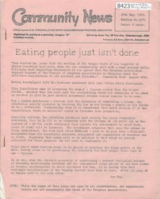
Newsletter, Greenhills and North Greensborough Progress Association, Community News: official journal of the Greenhills and North Greensborough Progress Association. 25th May, 1972. Edition No.3/72, 25/05/1972
This edition includes a report on the Progress Association's May 1972 meeting, Eating people just isn't done, A design with nature, Propagation by cuttings, Analysis: the Lake Pedder campaign, Save the kangaroo, Parochialism or maximum effectiveness, Churinga news, Diamond Valley Arts Society, Roads... we've got one at last!, Eltham Film Society, School news. A digital copy of this Newsletter is available from Greensborough Historical Society.Newsletter, 20 p., illus. greenhills and north greensborough progress association, greenhills -
 Eltham District Historical Society Inc
Photograph - Digital Photograph, Alan King, Pauline Toner Butterfly Reserve, 2008
One of seven sites in Eltham and Greensborough where the butterfly survives. Published: Nillumbik Now and Then / Marguerite Marshall 2008; photographs Alan King with Marguerite Marshall.; p181 The rare Eltham Copper Butterfly, Paralucia pyro-discus, was saved from near extinction by a community campaign in the late 1980s. Thanks to that effort, the butterfly, a form of the Fiery Copper Butterfly, with a wing span of only 2.5cm, can be seen in parts of Eltham and Greensborough from late November to April. As late as 1987 the butterfly was thought to be near extinction. But that year, entomologist, Michael Braby, found several colonies, including two major ones in natural bushland on Diosma Road, Eltham. However these were threatened with destruction, as their habitat was to be destroyed by a development of 71 houses. The colonies were on a 14 hectare subdivision owned by Esanda Finance, an ANZ Bank subsidiary. It would cost around $5 million, to reimburse the bank for the land. The butterfly, which depends on woodland, a stunted form of the Sweet Bursaria bush, and the Notoncus ant, was considered too fragile to relocate. Braby’s discovery led to a sometimes fiery two-year campaign, which even became an election issue. It involved the local community, local and state governments and the developer, before a compromise was reached. The larvae have an intricate relationship with the small black ant, Notoncus. During the day, the larvae shelter in nests made by the ants around the base of the trunk and roots of the Sweet Bursaria (Bursaria spinosa). The ants are thought to protect the larvae from predators and parasites, as they attend them from the nests to feed on the Bursaria leaves at night. In return, the larvae excrete a sugar solution, which the ants love to eat. The butterfly was first recorded in Victoria in 1893, and first collected scientifically from Eltham in 1931. But it was only officially named in 1951, by Victoria’s then top butterfly expert, David Crosby.2 However, from 1970, rapid housing development in Eltham destroyed much of the butterfly’s habitat. The discovery of several major colonies in 1987 met with great excitement, and 250 people attended the first local public meeting. The State Government commissioned Crosby to investigate how to protect the butterfly, and the council froze development for three weeks. Then Esanda agreed to suspend development for several months, until a compromise was reached. Crosby recommended that 62 of the 71 lots be kept to ensure the butterflys’ survival. However this would cost $1 million to $1.5million in compensation to Esanda. Greensborough MP Pauline Toner, launched a $1million fundraising campaign and many artists donated their works to the appeal. Toner offered Clifton Pugh’s painting Eltham Copper Country to millionaire Alan Bond for $1 million, after having heard that he had offered $6 million for the Van Gough painting Sunflowers. However Bond did not accept. The butterfly was considered a ‘hot’ election issue during the by-election, following Pauline Toner’s resignation. Liberal party candidate, Margaret Brown, was accused of falsely saying she had been involved in the butterfly campaign so as to win votes. Sadly, the $1million appeal fell short at $426,000, so a compromise was reached. The State Government donated the Education Department site on Eucalyptus Road, but only nine lots of the Diosma site were bought, and the rest of the development went ahead. On March 3, 1989, Ms Toner died. Thee Eucalyptus Road site was named in her honour. Around 2000 the butterfly was further threatened by proposed developments on Pitt Street, facing the Pauline Toner Reserve and between Diosma and Nyora Roads. Fortunately the Friends of the ECB, with the Shire of Nillumbik, ensured that more habitat was made available. The butterfly now survives in seven sites in Eltham and Greensborough, including the main sites at the Pauline Toner Reserve on Eucalyptus Road, the Western and Eastern colonies on Diosma Road, and the Yandell Reserve in Greensborough.5 The butterfly survives also in Castlemaine and in the Kiata and Salisbury areas. However, it remains endangered.This collection of almost 130 photos about places and people within the Shire of Nillumbik, an urban and rural municipality in Melbourne's north, contributes to an understanding of the history of the Shire. Published in 2008 immediately prior to the Black Saturday bushfires of February 7, 2009, it documents sites that were impacted, and in some cases destroyed by the fires. It includes photographs taken especially for the publication, creating a unique time capsule representing the Shire in the early 21st century. It remains the most recent comprehenesive publication devoted to the Shire's history connecting local residents to the past. nillumbik now and then (marshall-king) collection, eltham copper butterfly, pauline toner butterfly reserve -
 Eltham District Historical Society Inc
Photograph - Digital Photograph, Alan King, Sweet Bursaria, 2008
Published: Nillumbik Now and Then / Marguerite Marshall 2008; photographs Alan King with Marguerite Marshall.; p181 The rare Eltham Copper Butterfly, Paralucia pyro-discus, was saved from near extinction by a community campaign in the late 1980s. Thanks to that effort, the butterfly, a form of the Fiery Copper Butterfly, with a wing span of only 2.5cm, can be seen in parts of Eltham and Greensborough from late November to April. As late as 1987 the butterfly was thought to be near extinction. But that year, entomologist, Michael Braby, found several colonies, including two major ones in natural bushland on Diosma Road, Eltham. However these were threatened with destruction, as their habitat was to be destroyed by a development of 71 houses. The colonies were on a 14 hectare subdivision owned by Esanda Finance, an ANZ Bank subsidiary. It would cost around $5 million, to reimburse the bank for the land. The butterfly, which depends on woodland, a stunted form of the Sweet Bursaria bush, and the Notoncus ant, was considered too fragile to relocate. Braby’s discovery led to a sometimes fiery two-year campaign, which even became an election issue. It involved the local community, local and state governments and the developer, before a compromise was reached. The larvae have an intricate relationship with the small black ant, Notoncus. During the day, the larvae shelter in nests made by the ants around the base of the trunk and roots of the Sweet Bursaria (Bursaria spinosa). The ants are thought to protect the larvae from predators and parasites, as they attend them from the nests to feed on the Bursaria leaves at night. In return, the larvae excrete a sugar solution, which the ants love to eat. The butterfly was first recorded in Victoria in 1893, and first collected scientifically from Eltham in 1931. But it was only officially named in 1951, by Victoria’s then top butterfly expert, David Crosby.2 However, from 1970, rapid housing development in Eltham destroyed much of the butterfly’s habitat. The discovery of several major colonies in 1987 met with great excitement, and 250 people attended the first local public meeting. The State Government commissioned Crosby to investigate how to protect the butterfly, and the council froze development for three weeks. Then Esanda agreed to suspend development for several months, until a compromise was reached. Crosby recommended that 62 of the 71 lots be kept to ensure the butterflys’ survival. However this would cost $1 million to $1.5million in compensation to Esanda. Greensborough MP Pauline Toner, launched a $1million fundraising campaign and many artists donated their works to the appeal. Toner offered Clifton Pugh’s painting Eltham Copper Country to millionaire Alan Bond for $1 million, after having heard that he had offered $6 million for the Van Gough painting Sunflowers. However Bond did not accept. The butterfly was considered a ‘hot’ election issue during the by-election, following Pauline Toner’s resignation. Liberal party candidate, Margaret Brown, was accused of falsely saying she had been involved in the butterfly campaign so as to win votes. Sadly, the $1million appeal fell short at $426,000, so a compromise was reached. The State Government donated the Education Department site on Eucalyptus Road, but only nine lots of the Diosma site were bought, and the rest of the development went ahead. On March 3, 1989, Ms Toner died, and the Eucalyptus Road site was named in her honour. Around 2000 the butterfly was further threatened by proposed developments on Pitt Street, facing the Pauline Toner Reserve and between Diosma and Nyora Roads. Fortunately the Friends of the ECB, with the Shire of Nillumbik, ensured that more habitat was made available. The butterfly now survives in seven sites in Eltham and Greensborough, including the main sites at the Pauline Toner Reserve on Eucalyptus Road, the Western and Eastern colonies on Diosma Road, and the Yandell Reserve in Greensborough.The butterfly survives also in Castlemaine and in the Kiata and Salisbury areas. However, it remains endangered.This collection of almost 130 photos about places and people within the Shire of Nillumbik, an urban and rural municipality in Melbourne's north, contributes to an understanding of the history of the Shire. Published in 2008 immediately prior to the Black Saturday bushfires of February 7, 2009, it documents sites that were impacted, and in some cases destroyed by the fires. It includes photographs taken especially for the publication, creating a unique time capsule representing the Shire in the early 21st century. It remains the most recent comprehenesive publication devoted to the Shire's history connecting local residents to the past. nillumbik now and then (marshall-king) collection, eltham copper butterfly, sweet bursaria -
 Eltham District Historical Society Inc
Photograph, Looking north across the Fitzsimons Lane Bridge over Yarra River between Eltham and Templestowe, c.1985, 1985c
Turnoff to Candlebark Park on right. The bridge over the Yarra River was initially opened September 22nd, 1961. Newspaper reports at the time of opening stated it linked Bolton Street, Eltham, with Fitzsimons Lane, Templestowe. In 1955 the Country Roads Board (CRB) produced survey plans that showed proposed land acquisition for the future bridge and road approaches. The 1955 plan shows that it was proposed to connect Fitzsimons Lane with Bolton Street in Eltham by a diagonal road across the river. The road connection would then continue along Bolton Street to Main Road. Prior to construction of the bridge the CRB modified the proposal significantly so that there was a new road parallel with Bolton Street and then curving to join Main Road at what was then its intersection with Old Eltham Road. This involved significantly more land acquisition and altered the pattern of land subdivision through this corridor. Initially the new road was just a single two-way carriageway as it would have required a significant widening of the cutting on the Shire of Eltham side of the river. The road was officially un-named but was known locally as the Eltham-Templestowe Road. The 1966 Melway street directory and other 1960s editions also listed the road as the Eltham-Templestowe Road. In December 1970, Eltham Shire Council, in pursuance of the provisions of the Local Government Act, named it Templestowe Road. The road was renamed Fitzsimons Lane around 1984 in conformity with the section south of the river. In 1991 a new bridge was built to the west of the original bridge. Fitzsimons Lane was widened to four traffic lanes although on the Eltham side this was done within the limits of the existing cutting. NEW BRIDGE STARTS THEM EXPLORING Without any fanfares, Country Roads Board workmen on Friday afternoon put the finishing touches to the approaches, removed the barricades, and let the traffic roll over the new Yarra bridge linking Bolton Street, Eltham, with Fitzsimons Lane, Templestowe. Over the week-end many “bridge watchers” who were making one of their periodic inspections of the progress on the new bridge found to their surprise that they could drive over it, so that people who had gone for a run out to Eltham suddenly found themselves wandering through Templestowe and Doncaster. By Monday the word of the bridge’s opening had got around sufficiently for many regular travellers to the city from Eltham and beyond to vary the monotony by going to town via Templestowe and Kew instead of through Heidelberg. They were surprised at the distances – about 3 ½ miles from Eltham to Templestowe, 6 miles from Eltham Shire hall to the Lower Heidelberg Road-Banksia Street intersection. NEW NEIGHBOURS For people on both sides of the river, the new bridge has turned distant friends into near neighbours. A Greensborough man on Sunday took 35 minutes to reach the home of a friend in East Doncaster, but the return trip over the new bridge took only 17 minutes. It will be some time yet before most people work out the possibilities in shorter and quicker trips form the north-eastern areas to the eastern and south-eastern suburbs. The coming of the warmer months will soon teach many, though the short cuts to Peninsular beaches and eastern suburban drive-ins. And before very long it is likely there will be a Tramways bus running from Templestowe to Eltham station. NEW BRIDGE STARTS THEM EXPLORING (1961, September 27). The Diamond Valley News (News clipping held in SEA_74-1_047) The previously un-named road between Main Road and Yarra River, Eltham South, east of Bolton Street was named Templestowe Road, December 15, 1970 NAMING OF STREETS AND ROADS. (1970, December 15). The Diamond Valley News (News clipping held in SEA_74-2_022)Colour photographinfrastructure, shire of eltham infrastructure, bridge, fitzsimons lane bridge, yarra river, candlebark park, red nose day -
 Eltham District Historical Society Inc
Photograph, Fitzsimons Lane Bridge over Yarra River between Eltham and Templestowe
The bridge over the Yarra River was initially opened September 22nd, 1961. Newspaper reports at the time of opening stated it linked Bolton Street, Eltham, with Fitzsimons Lane, Templestowe. In 1955 the Country Roads Board (CRB) produced survey plans that showed proposed land acquisition for the future bridge and road approaches. The 1955 plan shows that it was proposed to connect Fitzsimons Lane with Bolton Street in Eltham by a diagonal road across the river. The road connection would then continue along Bolton Street to Main Road. Prior to construction of the bridge the CRB modified the proposal significantly so that there was a new road parallel with Bolton Street and then curving to join Main Road at what was then its intersection with Old Eltham Road. This involved significantly more land acquisition and altered the pattern of land subdivision through this corridor. Initially the new road was just a single two-way carriageway as it would have required a significant widening of the cutting on the Shire of Eltham side of the river. The road was officially un-named but was known locally as the Eltham-Templestowe Road. The 1966 Melway street directory and other 1960s editions also listed the road as the Eltham-Templestowe Road. In December 1970, Eltham Shire Council, in pursuance of the provisions of the Local Government Act, named it Templestowe Road. The road was renamed Fitzsimons Lane around 1984 in conformity with the section south of the river. In 1991 a new bridge was built to the west of the original bridge. Fitzsimons Lane was widened to four traffic lanes although on the Eltham side this was done within the limits of the existing cutting. NEW BRIDGE STARTS THEM EXPLORING Without any fanfares, Country Roads Board workmen on Friday afternoon put the finishing touches to the approaches, removed the barricades, and let the traffic roll over the new Yarra bridge linking Bolton Street, Eltham, with Fitzsimons Lane, Templestowe. Over the week-end many “bridge watchers” who were making one of their periodic inspections of the progress on the new bridge found to their surprise that they could drive over it, so that people who had gone for a run out to Eltham suddenly found themselves wandering through Templestowe and Doncaster. By Monday the word of the bridge’s opening had got around sufficiently for many regular travellers to the city from Eltham and beyond to vary the monotony by going to town via Templestowe and Kew instead of through Heidelberg. They were surprised at the distances – about 3 ½ miles from Eltham to Templestowe, 6 miles from Eltham Shire hall to the Lower Heidelberg Road-Banksia Street intersection. NEW NEIGHBOURS For people on both sides of the river, the new bridge has turned distant friends into near neighbours. A Greensborough man on Sunday took 35 minutes to reach the home of a friend in East Doncaster, but the return trip over the new bridge took only 17 minutes. It will be some time yet before most people work out the possibilities in shorter and quicker trips form the north-eastern areas to the eastern and south-eastern suburbs. The coming of the warmer months will soon teach many, though the short cuts to Peninsular beaches and eastern suburban drive-ins. And before very long it is likely there will be a Tramways bus running from Templestowe to Eltham station. NEW BRIDGE STARTS THEM EXPLORING (1961, September 27). The Diamond Valley News (News clipping held in SEA_74-1_047) The previously un-named road between Main Road and Yarra River, Eltham South, east of Bolton Street was named Templestowe Road, December 15, 1970 NAMING OF STREETS AND ROADS. (1970, December 15). The Diamond Valley News (News clipping held in SEA_74-2_022)Black and white photographinfrastructure, shire of eltham infrastructure, bridge, fitzsimons lane bridge, yarra river -
 Eltham District Historical Society Inc
Photograph, Looking south across the Fitzsimons Lane Bridge over Yarra River between Eltham and Templestowe
The bridge over the Yarra River was initially opened September 22nd, 1961. Newspaper reports at the time of opening stated it linked Bolton Street, Eltham, with Fitzsimons Lane, Templestowe. In 1955 the Country Roads Board (CRB) produced survey plans that showed proposed land acquisition for the future bridge and road approaches. The 1955 plan shows that it was proposed to connect Fitzsimons Lane with Bolton Street in Eltham by a diagonal road across the river. The road connection would then continue along Bolton Street to Main Road. Prior to construction of the bridge the CRB modified the proposal significantly so that there was a new road parallel with Bolton Street and then curving to join Main Road at what was then its intersection with Old Eltham Road. This involved significantly more land acquisition and altered the pattern of land subdivision through this corridor. Initially the new road was just a single two-way carriageway as it would have required a significant widening of the cutting on the Shire of Eltham side of the river. The road was officially un-named but was known locally as the Eltham-Templestowe Road. The 1966 Melway street directory and other 1960s editions also listed the road as the Eltham-Templestowe Road. In December 1970, Eltham Shire Council, in pursuance of the provisions of the Local Government Act, named it Templestowe Road. The road was renamed Fitzsimons Lane around 1984 in conformity with the section south of the river. In 1991 a new bridge was built to the west of the original bridge. Fitzsimons Lane was widened to four traffic lanes although on the Eltham side this was done within the limits of the existing cutting. NEW BRIDGE STARTS THEM EXPLORING Without any fanfares, Country Roads Board workmen on Friday afternoon put the finishing touches to the approaches, removed the barricades, and let the traffic roll over the new Yarra bridge linking Bolton Street, Eltham, with Fitzsimons Lane, Templestowe. Over the week-end many “bridge watchers” who were making one of their periodic inspections of the progress on the new bridge found to their surprise that they could drive over it, so that people who had gone for a run out to Eltham suddenly found themselves wandering through Templestowe and Doncaster. By Monday the word of the bridge’s opening had got around sufficiently for many regular travellers to the city from Eltham and beyond to vary the monotony by going to town via Templestowe and Kew instead of through Heidelberg. They were surprised at the distances – about 3 ½ miles from Eltham to Templestowe, 6 miles from Eltham Shire hall to the Lower Heidelberg Road-Banksia Street intersection. NEW NEIGHBOURS For people on both sides of the river, the new bridge has turned distant friends into near neighbours. A Greensborough man on Sunday took 35 minutes to reach the home of a friend in East Doncaster, but the return trip over the new bridge took only 17 minutes. It will be some time yet before most people work out the possibilities in shorter and quicker trips form the north-eastern areas to the eastern and south-eastern suburbs. The coming of the warmer months will soon teach many, though the short cuts to Peninsular beaches and eastern suburban drive-ins. And before very long it is likely there will be a Tramways bus running from Templestowe to Eltham station. NEW BRIDGE STARTS THEM EXPLORING (1961, September 27). The Diamond Valley News (News clipping held in SEA_74-1_047) The previously un-named road between Main Road and Yarra River, Eltham South, east of Bolton Street was named Templestowe Road, December 15, 1970 NAMING OF STREETS AND ROADS. (1970, December 15). The Diamond Valley News (News clipping held in SEA_74-2_022)Black and white photographinfrastructure, shire of eltham infrastructure, bridge, fitzsimons lane bridge, yarra river -
 Eltham District Historical Society Inc
Photograph, Fitzsimons Lane Bridge over Yarra River between Eltham and Templestowe
The bridge over the Yarra River was initially opened September 22nd, 1961. Newspaper reports at the time of opening stated it linked Bolton Street, Eltham, with Fitzsimons Lane, Templestowe. In 1955 the Country Roads Board (CRB) produced survey plans that showed proposed land acquisition for the future bridge and road approaches. The 1955 plan shows that it was proposed to connect Fitzsimons Lane with Bolton Street in Eltham by a diagonal road across the river. The road connection would then continue along Bolton Street to Main Road. Prior to construction of the bridge the CRB modified the proposal significantly so that there was a new road parallel with Bolton Street and then curving to join Main Road at what was then its intersection with Old Eltham Road. This involved significantly more land acquisition and altered the pattern of land subdivision through this corridor. Initially the new road was just a single two-way carriageway as it would have required a significant widening of the cutting on the Shire of Eltham side of the river. The road was officially un-named but was known locally as the Eltham-Templestowe Road. The 1966 Melway street directory and other 1960s editions also listed the road as the Eltham-Templestowe Road. In December 1970, Eltham Shire Council, in pursuance of the provisions of the Local Government Act, named it Templestowe Road. The road was renamed Fitzsimons Lane around 1984 in conformity with the section south of the river. In 1991 a new bridge was built to the west of the original bridge. Fitzsimons Lane was widened to four traffic lanes although on the Eltham side this was done within the limits of the existing cutting. NEW BRIDGE STARTS THEM EXPLORING Without any fanfares, Country Roads Board workmen on Friday afternoon put the finishing touches to the approaches, removed the barricades, and let the traffic roll over the new Yarra bridge linking Bolton Street, Eltham, with Fitzsimons Lane, Templestowe. Over the week-end many “bridge watchers” who were making one of their periodic inspections of the progress on the new bridge found to their surprise that they could drive over it, so that people who had gone for a run out to Eltham suddenly found themselves wandering through Templestowe and Doncaster. By Monday the word of the bridge’s opening had got around sufficiently for many regular travellers to the city from Eltham and beyond to vary the monotony by going to town via Templestowe and Kew instead of through Heidelberg. They were surprised at the distances – about 3 ½ miles from Eltham to Templestowe, 6 miles from Eltham Shire hall to the Lower Heidelberg Road-Banksia Street intersection. NEW NEIGHBOURS For people on both sides of the river, the new bridge has turned distant friends into near neighbours. A Greensborough man on Sunday took 35 minutes to reach the home of a friend in East Doncaster, but the return trip over the new bridge took only 17 minutes. It will be some time yet before most people work out the possibilities in shorter and quicker trips form the north-eastern areas to the eastern and south-eastern suburbs. The coming of the warmer months will soon teach many, though the short cuts to Peninsular beaches and eastern suburban drive-ins. And before very long it is likely there will be a Tramways bus running from Templestowe to Eltham station. NEW BRIDGE STARTS THEM EXPLORING (1961, September 27). The Diamond Valley News (News clipping held in SEA_74-1_047) The previously un-named road between Main Road and Yarra River, Eltham South, east of Bolton Street was named Templestowe Road, December 15, 1970 NAMING OF STREETS AND ROADS. (1970, December 15). The Diamond Valley News (News clipping held in SEA_74-2_022)Black and white photographinfrastructure, shire of eltham infrastructure, bridge, fitzsimons lane bridge, yarra river -
 Greensborough Historical Society
Poster - Planning Document, Shire of Diamond Valley et al, Subdivision Plan # 1018 - Parish of Nillumbik, County Bourke, Crown Allotment 4 Section 15, and Crown Allotment B Section 12, Eltham North, 1981-1982
Subdivision Plan # 1018 - Parish of Nillumbik, County Bourke, Crown Allotment 4 Section 15, and Crown Allotment B Section 12, Eltham North. This subdivision plan includes Ryans Road (also known as Government Road) and St Clems Street. The developer for this subdivision is Taunton Developments and the Surveyors are Fisher Cleeland Turner & Dwyer Vic, Surveyors and Engineers.An example of hard copy subdivision plans from the Greensborough area. Mainly from the Shire of Diamond Valley era (1964-1994).Plan (single sided) mounted on heavy card. Stamped and handwritten Council permissions, dates and other details. subdivision plans, shire of diamond valley, taunton developments -
 Greensborough Historical Society
Poster - Planning Document, Shire of Diamond Valley et al, Subdivision Plan # 1026 - Parish of Nillumbik, County Bourke, Crown Allotment B Section 12, Eltham North, 1981-1984
Subdivision Plan # 1026 - Parish of Nillumbik, County Bourke, Crown Allotment B Section 12, Eltham North. This subdivision plan includes Ryans Road (also known as Government Road) and St Clems Street. The developer for this subdivision is Taunton Developments and the Surveyors are Fisher Cleeland Turner & Dwyer Vic, Surveyors and Engineers.An example of hard copy subdivision plans from the Greensborough area. Mainly from the Shire of Diamond Valley era (1964-1994).Plan (single sided) mounted on heavy card. Stamped and handwritten Council permissions, dates and other details. subdivision plans, shire of diamond valley, taunton developments -
 Greensborough Historical Society
Poster - Planning Document, Shire of Diamond Valley et al, Subdivision Plan # 1044 - Parish of Nillumbik, County Bourke, Crown Allotment B Section 12, Eltham North, 1981-1987
Subdivision Plan # 1044 - Parish of Nillumbik, County Bourke, Crown Allotment B Section 12, Eltham North. This subdivision plan includes Weidlich Road and St Clems Street. The developer for this subdivision is Taunton Developments and the Surveyors are Fisher Cleeland Turner & Dwyer Vic, Surveyors and Engineers.An example of hard copy subdivision plans from the Greensborough area. Mainly from the Shire of Diamond Valley era (1964-1994).Plan (single sided) mounted on heavy card. Stamped and handwritten Council permissions, dates and other details. subdivision plans, shire of diamond valley, taunton developments -
 Eltham District Historical Society Inc
Photograph, Russell Yeoman, Fitzsimons Lane Bridge over Yarra River between Eltham and Templestowe, c.1970, 1970c
The bridge over the Yarra River was initially opened September 22nd, 1961. Newspaper reports at the time of opening stated it linked Bolton Street, Eltham, with Fitzsimons Lane, Templestowe. In 1955 the Country Roads Board (CRB) produced survey plans that showed proposed land acquisition for the future bridge and road approaches. The 1955 plan shows that it was proposed to connect Fitzsimons Lane with Bolton Street in Eltham by a diagonal road across the river. The road connection would then continue along Bolton Street to Main Road. Prior to construction of the bridge the CRB modified the proposal significantly so that there was a new road parallel with Bolton Street and then curving to join Main Road at what was then its intersection with Old Eltham Road. This involved significantly more land acquisition and altered the pattern of land subdivision through this corridor. Initially the new road was just a single two-way carriageway as it would have required a significant widening of the cutting on the Shire of Eltham side of the river. The road was officially un-named but was known locally as the Eltham-Templestowe Road. The 1966 Melway street directory and other 1960s editions also listed the road as the Eltham-Templestowe Road. In December 1970, Eltham Shire Council, in pursuance of the provisions of the Local Government Act, named it Templestowe Road. The road was renamed Fitzsimons Lane around 1984 in conformity with the section south of the river. In 1991 a new bridge was built to the west of the original bridge. Fitzsimons Lane was widened to four traffic lanes although on the Eltham side this was done within the limits of the existing cutting. NEW BRIDGE STARTS THEM EXPLORING Without any fanfares, Country Roads Board workmen on Friday afternoon put the finishing touches to the approaches, removed the barricades, and let the traffic roll over the new Yarra bridge linking Bolton Street, Eltham, with Fitzsimons Lane, Templestowe. Over the week-end many “bridge watchers” who were making one of their periodic inspections of the progress on the new bridge found to their surprise that they could drive over it, so that people who had gone for a run out to Eltham suddenly found themselves wandering through Templestowe and Doncaster. By Monday the word of the bridge’s opening had got around sufficiently for many regular travellers to the city from Eltham and beyond to vary the monotony by going to town via Templestowe and Kew instead of through Heidelberg. They were surprised at the distances – about 3 ½ miles from Eltham to Templestowe, 6 miles from Eltham Shire hall to the Lower Heidelberg Road-Banksia Street intersection. NEW NEIGHBOURS For people on both sides of the river, the new bridge has turned distant friends into near neighbours. A Greensborough man on Sunday took 35 minutes to reach the home of a friend in East Doncaster, but the return trip over the new bridge took only 17 minutes. It will be some time yet before most people work out the possibilities in shorter and quicker trips form the north-eastern areas to the eastern and south-eastern suburbs. The coming of the warmer months will soon teach many, though the short cuts to Peninsular beaches and eastern suburban drive-ins. And before very long it is likely there will be a Tramways bus running from Templestowe to Eltham station. NEW BRIDGE STARTS THEM EXPLORING (1961, September 27). The Diamond Valley News (News clipping held in SEA_74-1_047) The previously un-named road between Main Road and Yarra River, Eltham South, east of Bolton Street was named Templestowe Road, December 15, 1970 NAMING OF STREETS AND ROADS. (1970, December 15). The Diamond Valley News (News clipping held in SEA_74-2_022)Roll of 35mm black and white negative film, 4 of 7 stripsIlford HP4bridge, bridges, fitzsimons lane bridge, infrastructure, shire of eltham infrastructure, yarra river -
 Eltham District Historical Society Inc
Photograph, Fitzsimons Lane Bridge over Yarra River between Eltham and Templestowe, c.1966, 1966c
The bridge over the Yarra River was initially opened September 22nd, 1961. Newspaper reports at the time of opening stated it linked Bolton Street, Eltham, with Fitzsimons Lane, Templestowe. In 1955 the Country Roads Board (CRB) produced survey plans that showed proposed land acquisition for the future bridge and road approaches. The 1955 plan shows that it was proposed to connect Fitzsimons Lane with Bolton Street in Eltham by a diagonal road across the river. The road connection would then continue along Bolton Street to Main Road. Prior to construction of the bridge the CRB modified the proposal significantly so that there was a new road parallel with Bolton Street and then curving to join Main Road at what was then its intersection with Old Eltham Road. This involved significantly more land acquisition and altered the pattern of land subdivision through this corridor. Initially the new road was just a single two-way carriageway as it would have required a significant widening of the cutting on the Shire of Eltham side of the river. The road was officially un-named but was known locally as the Eltham-Templestowe Road. The 1966 Melway street directory and other 1960s editions also listed the road as the Eltham-Templestowe Road. In December 1970, Eltham Shire Council, in pursuance of the provisions of the Local Government Act, named it Templestowe Road. The road was renamed Fitzsimons Lane around 1984 in conformity with the section south of the river. In 1991 a new bridge was built to the west of the original bridge. Fitzsimons Lane was widened to four traffic lanes although on the Eltham side this was done within the limits of the existing cutting. NEW BRIDGE STARTS THEM EXPLORING Without any fanfares, Country Roads Board workmen on Friday afternoon put the finishing touches to the approaches, removed the barricades, and let the traffic roll over the new Yarra bridge linking Bolton Street, Eltham, with Fitzsimons Lane, Templestowe. Over the week-end many “bridge watchers” who were making one of their periodic inspections of the progress on the new bridge found to their surprise that they could drive over it, so that people who had gone for a run out to Eltham suddenly found themselves wandering through Templestowe and Doncaster. By Monday the word of the bridge’s opening had got around sufficiently for many regular travellers to the city from Eltham and beyond to vary the monotony by going to town via Templestowe and Kew instead of through Heidelberg. They were surprised at the distances – about 3 ½ miles from Eltham to Templestowe, 6 miles from Eltham Shire hall to the Lower Heidelberg Road-Banksia Street intersection. NEW NEIGHBOURS For people on both sides of the river, the new bridge has turned distant friends into near neighbours. A Greensborough man on Sunday took 35 minutes to reach the home of a friend in East Doncaster, but the return trip over the new bridge took only 17 minutes. It will be some time yet before most people work out the possibilities in shorter and quicker trips form the north-eastern areas to the eastern and south-eastern suburbs. The coming of the warmer months will soon teach many, though the short cuts to Peninsular beaches and eastern suburban drive-ins. And before very long it is likely there will be a Tramways bus running from Templestowe to Eltham station. NEW BRIDGE STARTS THEM EXPLORING (1961, September 27). The Diamond Valley News (News clipping held in SEA_74-1_047) The previously un-named road between Main Road and Yarra River, Eltham South, east of Bolton Street was named Templestowe Road, December 15, 1970 NAMING OF STREETS AND ROADS. (1970, December 15). The Diamond Valley News (News clipping held in SEA_74-2_022)Black and white photographManufacturer's marks: Polaroid, Batch #J62K181 (Sep 1966).infrastructure, shire of eltham infrastructure, bridge, fitzsimons lane bridge, polaroid, yarra river -
 Eltham District Historical Society Inc
Photograph, Fitzsimons Lane Bridge over Yarra River between Eltham and Templestowe
The bridge over the Yarra River was initially opened September 22nd, 1961. Newspaper reports at the time of opening stated it linked Bolton Street, Eltham, with Fitzsimons Lane, Templestowe. In 1955 the Country Roads Board (CRB) produced survey plans that showed proposed land acquisition for the future bridge and road approaches. The 1955 plan shows that it was proposed to connect Fitzsimons Lane with Bolton Street in Eltham by a diagonal road across the river. The road connection would then continue along Bolton Street to Main Road. Prior to construction of the bridge the CRB modified the proposal significantly so that there was a new road parallel with Bolton Street and then curving to join Main Road at what was then its intersection with Old Eltham Road. This involved significantly more land acquisition and altered the pattern of land subdivision through this corridor. Initially the new road was just a single two-way carriageway as it would have required a significant widening of the cutting on the Shire of Eltham side of the river. The road was officially un-named but was known locally as the Eltham-Templestowe Road. The 1966 Melway street directory and other 1960s editions also listed the road as the Eltham-Templestowe Road. In December 1970, Eltham Shire Council, in pursuance of the provisions of the Local Government Act, named it Templestowe Road. The road was renamed Fitzsimons Lane around 1984 in conformity with the section south of the river. In 1991 a new bridge was built to the west of the original bridge. Fitzsimons Lane was widened to four traffic lanes although on the Eltham side this was done within the limits of the existing cutting. NEW BRIDGE STARTS THEM EXPLORING Without any fanfares, Country Roads Board workmen on Friday afternoon put the finishing touches to the approaches, removed the barricades, and let the traffic roll over the new Yarra bridge linking Bolton Street, Eltham, with Fitzsimons Lane, Templestowe. Over the week-end many “bridge watchers” who were making one of their periodic inspections of the progress on the new bridge found to their surprise that they could drive over it, so that people who had gone for a run out to Eltham suddenly found themselves wandering through Templestowe and Doncaster. By Monday the word of the bridge’s opening had got around sufficiently for many regular travellers to the city from Eltham and beyond to vary the monotony by going to town via Templestowe and Kew instead of through Heidelberg. They were surprised at the distances – about 3 ½ miles from Eltham to Templestowe, 6 miles from Eltham Shire hall to the Lower Heidelberg Road-Banksia Street intersection. NEW NEIGHBOURS For people on both sides of the river, the new bridge has turned distant friends into near neighbours. A Greensborough man on Sunday took 35 minutes to reach the home of a friend in East Doncaster, but the return trip over the new bridge took only 17 minutes. It will be some time yet before most people work out the possibilities in shorter and quicker trips form the north-eastern areas to the eastern and south-eastern suburbs. The coming of the warmer months will soon teach many, though the short cuts to Peninsular beaches and eastern suburban drive-ins. And before very long it is likely there will be a Tramways bus running from Templestowe to Eltham station. NEW BRIDGE STARTS THEM EXPLORING (1961, September 27). The Diamond Valley News (News clipping held in SEA_74-1_047) The previously un-named road between Main Road and Yarra River, Eltham South, east of Bolton Street was named Templestowe Road, December 15, 1970 NAMING OF STREETS AND ROADS. (1970, December 15). The Diamond Valley News (News clipping held in SEA_74-2_022)Black and white photographinfrastructure, shire of eltham infrastructure, bridge, fitzsimons lane bridge, yarra river -
 Eltham District Historical Society Inc
Audio - Audio Recording, Audio Recording; 2016-06-08 Norm Williams and Thompson's Pharmacy, 8 Jun 2016
June Meeting (Newsletter No. 228, Jun. 2016) Shortly after the First World War Ivan Thompson, a pharmacist in Fairfield, expanded into the Diamond Valley by opening pharmacies at Eltham, Greensborough and Watsonia. A small item in the Hurstbridge Advertiser on 20th July 1928 states that ‘Mr. Ivan J Thompson, well known chemist, has opened a branch at Eltham where all prescriptions will be dispensed.’ In the early 1950’s Norm Williams considered he was fortunate to be able to serve an apprenticeship with Ivan Thompson at his Eltham pharmacy. He was with the business when it moved in 1952 to the present site at 964 Main Road, Eltham, which was the first brick shop built in the Eltham Town Centre. In 1958 Ivan Thompson decided to sell his pharmacies. Harry Brown and Norm Williams were able to purchase the Eltham business and they continued in partnership until Mr. Brown’s death in 1971. By that time they had expanded with pharmacies in Fairfield and Lower Plenty. At our June meeting Norm Williams will speak about how Thompsons Pharmacy developed, while continuing to supply a range of services for generations of Eltham families. His stories, supported by a collection of personal photographs, will entertain as well as give an insight into how the Eltham shopping centre has changed over the years.0:46:09 duration Digital MP3 File 65 MB audio recording, eltham district historical society, ivan thompson, norm williams, society meeting, thompson's pharmacy -
 Eltham District Historical Society Inc
Document - Folder, Orford family
The Orford family, a pioneer family remained continuously living and working in Eltham for 170 years from 1854 to 2024. James and Sarah Orford arrived in Sydney in 1839 aboard the ship “Orestes”; they had several children there before settling in Eltham in 1854. Three children, James Mathias, Sarah Amelia and Thomas Henry initially remained in the Eltham area. James eventually moved to Brunswick. Sarah married Arthur Butler Young and finally lived in Bunyip. Thomas who was six years old when the family arrived in 1854 remained in Eltham, married Helen Logan who died, leaving a large family. They lived in a slab hut by the Yarra at Laughing Waters and Thomas managed the Panton Park Estate, a selection owned by Magistrate Thomas Panton. Thomas’s son, Ernest Orford was born 1892 at Pitt Street, Eltham and also lived his entire life in Eltham working as a labourer, orchardist and later as a gardener and grounds keeper for Sir William Irvine, a former Chief Justice and Premier of Victoria. Ernest married Kate Thomas; their two sons Ron and Doug stayed in the area. Another of Thomas' sons, Arthur, also lived in Eltham. Four Orford generations attended Eltham schools. Doug Orford was born on the kitchen table (reference, son Ted Orford) of the family home at the corner of Reynolds Road and Mount Pleasant Road. Doug married Gwen and they established a family however Gwen died at a young age from cancer. Doug eventually remarried another Gwen and they lived for several decades in Napoleon Street, Eltham. Doug was actively involved in EDHS over many years, including serving as a committee member and vice president. Contributions by Doug and Gwen (Treasurer/Membership Secretary), his wife, assisted EDHS to continue to develop as a not-for-profit group intent on promoting and preserving our local history. Both Doug and Gwen were made Life Members of EDHS. They also acted as EDHS delegates to the Eastern Region of Historical Societies. His significant work with assisting to establish our valued Local History Centre helped develop our home base and supported the continued growth of our society. Doug’s local knowledge, suggestions and family connections were highly valued, Until recent times, he continued to regularly attend our Collections Team workshops providing his insights and historical information about photographs and society records. Doug died peacefully July 8, 2024, and represents the last link in the Orford Eltham chain which spanned 170 years. His funeral was held Thursday, July 18, 2024, at Le Pine Funerals, 848 Main Road, Eltham. Contents: Typed notes, no date: Memories of Ernest Orford [taped 1979] about his school days. Handwritten notes, no date: History of Ernie Orford Typed notes, no date: History of Thomas Henry Orford and family. Photocopy: Shire of Eltham General Rate Receipts. Received from D Orford 7 June 1923 and Received from E F Orford, 4 August 1924. Letter, no date: Nillumbik Shire to Russell Yeoman, Gwen Orford to receive Volunteer Recognition Award. Newsletter article: "The Orford Family, Eltham", Shire of Eltham Historical Society, No.80 September 1991. History of Orford family. Handwritten notes: 21 March 2011, genealogy of George Orford. On reverse Melways map makred with Orford and other land ownerships. Newspaper advertisement, 21 March 2011: "264 Reynolds Road, South Eltham", property for sale [land in ownership of Orford family]. Letter: St Margaret's Anglican Church Eltham to Doug Orford, 17 November 2011, Extracts from church records relative to Orford family. Newspaper article: "Timely facelift at war memorials', Diamond Valley Leader, 30 April 2024, Nillumbik war memorial will have some work and a bronze plaque will be installed at the Eltham Avenue of Honour, Wingrove Park; photograph of Doug Orford Newsletter item: "Welcome home medal", Eltham District Historical Society newsletter no.216 May 2014, World War I two 'Welcome Home Medals' in ownership of local men, being Harry Gilham and Doug Orford. Order of Service, Le Pine Funerals (Eltham), In Loving Memory of Douglas Frederick Orford 22nd August 1929 - 8th July 2024 Doug Orford Reminiscences (2002) in conjunction with Jock Read and Peter Bassett Smith; 4 pages - 3 typed, 1 handwritten possibly transcribed from an audio tape recording (location unknown). New word file and associated pdf created [\Dropbox\EDHS DATA\DOCUMENTS\COLLECTION CATALOGUE DOCUMENTS AND PDFs\2-2 Family Folders\EDHS_06110-2 Doug Orford reminiscences 2002.docx - 1 April 2025]Newspaper clippings, A4 photocopies, etcdoug orford, harry gilham, welcome home medal, eltham avenue of honour, nillumbik war memorial, wingrove park, henry dendy, alfred armstrong, james orford, 264 reynolds road south eltham, george orford, george joseph orford, maryanne george joseph, thomas henry orford, ernest orford, e f orford, eltham cemetery, helen orford, joseph panton, panton park, gordon lyon, banyule estate heidelberg, james matthias orford, wurundjeri, constable peter lawlor, george hill, franklin street eltham, ronald orford, eltham primary school, john brown, robert gamble school inspector, sarah orford, mary ann orford, james mathias orford, sarah amelia orford, james peet, arthur butler young, watsons creek victoria, kangaroo ground victoria, helen logan, william orford, jane orford, arthur orford, frederick orford, florrie orford, victor orford, chem orford, sunnymede eltham, panton hill estate, sir william irvine, gordon lyons, kate thomas, north eltham gospel church, harold clapp, eltham cricket club, research primary school, dalton street school eltham, keith banks, betty banks, benjamine boyd, laughing waters road eltham, freddie gilsinen, douglas frederick orford, eltham district historical society, funeral service, le pine funeral home, life member, order of service, 1934 flood, 1939 bushfires, alcock & pierce, ansell, associated schools sports, blacksmith shop, boakes, bridge street, bryce family, bullock track, butcher, catholic church, cliff lester, cliffy green, daisy smith, dave lyon, diamond creek, diana bassett smith, dick tooth, dr. frank may, eltham higher elementary school, ernie andrew, fire station, flower stall, fodder business, fruit shop, furniture store, gahan family, garni burges, greensborough, harold norman, harry hawker, hat factory, hawker & owen, hay and com store, henry hawker, henry street, j .harry butherway, jack burgoyne, jack ryan, jock read, john lyon, junk yard, kevin gahan, kilpatricks, len parsons, lyon family, machine factory, mc leans, memorial, metery road, miss reynolds, monteith 's bus, mr. gadd, mrs. bird, mrs. morrison, napoleon street, peter bassett smith, peter's gahan, plenty river, plumridge, produce store, public hall, rechabite hall, reynolds road, roger bird, rutter family, ryan family, shoe factory., staffs produce store, studley cairn gahan, sweeneys lane, swimming pool, taylor street, tennis court, warren family, wooden bridge, yarra brae road