Showing 12752 items
matching estates
-
 Whitehorse Historical Society Inc.
Document, Fulton Park Estate, 1970s
Real estate brochure for the sale of 49 blocks at Fulton Park Estate Blackburn South.Real estate brochure for the sale of 49 blocks at Fulton Park Estate Blackburn South. Agents: E Flintoff & Sons and K F LangReal estate brochure for the sale of 49 blocks at Fulton Park Estate Blackburn South. fulton road, blackburn south, freda court, blackburn south, lucia street, blackburn south, mira street, blackburn south, lana street, blackburn south, residential development, fulton park estate -
 City of Kingston
Pamphlet - Colour, Ozone Hill Estate, Cheltenham, 1923
Sales plan for land in the suburb of Cheltenham, along both sides of Victori Avenue, off Weatherall Road.The developing urban area of Cheltenham within the City of Kingston. This land sale pamphlet illustrates the subdivision of land within the municipality and the changing demographic of the district as new houses are constructed.Colour pamphlet advertising for sale the Ozone Hill Estate, Cheltenham. Incorporates a map of the estate on either side of Victor Avenue, off Weatherall Road. Handwritten in blue ink on the subdivision map: 'Sold' is written on subdivisions 1-4, 8, 11, 13, 16-26, 28, 29, 33, 39-41 Handwritten in blue ink on the subdivision map: 'House being erected' is written on subdivisions 22 and 33. Handwrittten in grey pencil adjacent to subdivisions 21 and 22: Tennis / Courts / being / constructed / here Handwritten in grey pencil at bottom of page: Revised to 30/1/24 Handwritten in grey pencil on subdivision map: assumed land sale price is recorded on subdivisions 5-9, 9-10, 12, 14-15, 27, 30-32, 34-38. land sales, cheltenham, estate -
 City of Kingston
Pamphlet - Colour, Stillwell and Co, Cheltenham Charman Estate Realising Auction, 1921
Sales plan for land in the suburb of Cheltenham, along Charman Road and Weatherall Street.The developing urban area of Cheltenham within the City of Kingston. This land sale pamphlet illustrates the subdivision of land within the municipality and the changing demographic of the district as new houses are constructed.Colour pamphlet advertising realising auction of the Charman Estate, Cheltenham. Incorporates a map of the estate, showing subdivisions along Charman Road and Weatherall Street.land sales, cheltenham, estate -
 Bacchus Marsh & District Historical Society
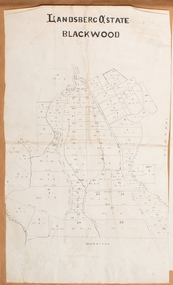
Map, Landsberg Estate Blackwood
The date this map was created has not been identified. It was possibly created at the time the Landsberg Estate near Blackwood was subdivided and sold into smaller lots in December 1886.Single page map showing land allotments which made up the Landsberg Estate near Blackwood. Scale 20 chains to 1 inch. The map is pasted into a bound volume containing 76 maps or plans in total. High resolution digital image stored on BMDHS computer network. bacchus marsh victoria maps, landsberg estate blackwood -
 Greensborough Historical Society
Newspaper Clipping, Domain Review et al, 10 Ellen Court Greensborough, 21/11/2018
11 Ellen Court Greensborough, 3 bedroom home, sold 21/11/2018 for $890,000; previous sales: September 2003 $325,000, May 1984 $73,500, December 1983 $21,000, and March 1980 $13,500.Real estate advertising in newspaper, colour imageellen court greensborough -
 Greensborough Historical Society
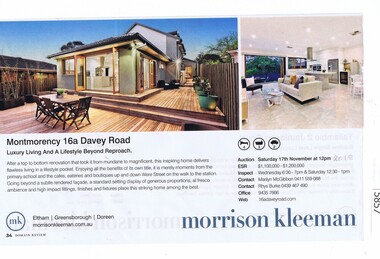
Newspaper Clipping, Domain Review et al, 16a Davey Road Montmorency, 17/11/2018
16a Davey Road Montmorency, 4 bedroom home, sold 17/11/2018 for $1,050,000; previous sales: October 2012 $585,000. Real estate advertising in newspaper, colour imagedavey road montmorency -
 Greensborough Historical Society
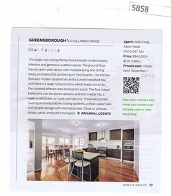
Newspaper Clipping, Domain Review et al, 51 Killarney Ridge Greensborough, 16/11/2018
51 Killarney Ridge Greensborough, 4 bedroom home, sold 16/11/2018 for $951,000; previous sales: December 2002 $178,000. Real estate advertising in newspaper, colour imagekillarney ridge greensborough -
 Greensborough Historical Society
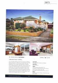
Advertising Leaflet, Buckingham and Company Estate Agents, 36 Orana Drive Watsonia, 2018_08
Advertising for 36 Orana Drive Watsonia, 3 bedroom house, sold December 2018 for $715,000. Colour page from real estate magazine.orana drive watsonia -
 Greensborough Historical Society
Advertising Leaflet, Buckingham and Company Estate Agents, 8 Glengala Court Greensborough, 2018_08
Advertising for 8 Glengala Court Greensborough, 3 bedroom house, sold October 2018 for $790,000; previous sales: February 2014 $552,500, April 1982 $68,000 and September 1977 $14,500. Colour page from real estate magazine.glengala court greensborough -
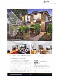
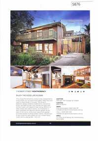 Greensborough Historical Society
Advertising Leaflet, Buckingham and Company Estate Agents, 11 Robert Street Montmorency, 2018_11
Advertising for 11 Robert Street Montmorency, 3 bedroom house, sold November 2018 for $767,000. Previous sales: August 1999 for $198,500 and May 1979 $16,500.Colour page from real estate magazine. robert street montmorency -
![Advertising Leaflet, 27 Pinehills Road (sic) [Drive], 05/08/2013](/media/collectors/4f729f5697f83e03086015b8/items/5b34426c21ea6b0a9c4e84d3/item-media/5b5e964621ea7b15487c21fd/item-fit-380x285.jpg) Greensborough Historical Society
Greensborough Historical SocietyAdvertising Leaflet, 27 Pinehills Road (sic) [Drive], 05/08/2013
27 Pinehills Drive, 4 bedroom 2 storey home auctioned 31 August 2013, sold for $620,0004 page colour real estate leafletpinehills drive greensborough -
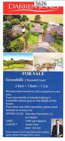 Greensborough Historical Society
Advertising Leaflet, 2 Noorabil Court Greenhills, 15/12/2012
2 Noorbil Court Greenhills. 2 bedroom home, private sale, sold 15 December 2012 for $460,000Real estate advertising leaflet, printed in colournoorabil court greensborough -
Ringwood and District Historical Society
Envelope, Sales, Auctions and Subdivisions - Pinemont Estate, Ringwood 1931
Sales, Auctions and Subdivisions - Pinemont Estate 1931 -
Stawell Historical Society Inc
Map, The Litho Co Ballarat, Glyntowyn Estate Campbells Bridge 1909, 1909
Shows Hoestead CC McCulloch ESQPaper map / Poster Advertising Subdivision of EstateMitchell Bros & White. 5003 Acres The Litho Co Ballarat Black Printing with Red Coloured Sectionsfarming -
Whitehorse Historical Society Inc.
Article, Mitcham, 2002
A real estate article on the residential area of MitchamA real estate article on the residential area of MitchamA real estate article on the residential area of Mitchammitcham, wattle valley road, mitcham, no 55, sebald, david, reeves, lisa -
 Whitehorse Historical Society Inc.
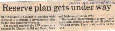
Article, Reserve plan gets under way, 6/10/1992 12:00:00 AM
Article on the development planArticle on the development plan of the Hale Estate, Mitcham.Article on the development planhale estate, mitcham, glenburnie road, orion street, vermont, grey street, malvern street, land subdivision -
 Whitehorse Historical Society Inc.
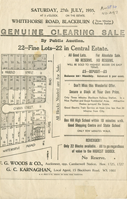
Document, Central Estate, 1935
Clearing saleClearing sale - 22 lots in Central Estate.Clearing sale g. woods & co. auctioneer, g. c. karnaghan estate agent, whitehorse road, blackburn, williams road, harold street, o'hara street -
Whitehorse Historical Society Inc.
Article, Ideal for a Home Based Business, 1985
1880 Timber House for sale.1880 Timber House for sale. An early owner was William Ellingworth, whose son John established one of the areas first Real Estate Agencies. In 1956 John Robinson bought the property and taught Piano Accordion and Guitar for over 29 years at this house.1880 Timber House for sale. rose street, box hill, no. 28, ellingworth, william, robinson, john, box hill music centre -
 Ringwood and District Historical Society
Map - State Aerial Survey, Dandenong Ranges Area Sheet 7, Parishes of Warrandyte, Scoresby, Ringwood and Nunawading - 1956
Map of central and southern areas of Ringwood and part of Ringwood East and Heathmont compiled by Dept of Lands and Survey, July 1956, from aerial photographs and Cadastral Survey information. Subsequent coloured hand-drawn additions showing layout of a number of post-NSW Separation era proposed subdivisions that did not eventuate, including Village of Studley Estate, Township of East Kew Estate, Township of Ballyduffy Estate, Township of New Flemington Estate, Township of East Hawthorne Estate. Ringwood A4B2, 849 A4B Zone 7. Scale: 10 chains to 1 inch. Contour interval 20 feet. -
 Kew Historical Society Inc
Plan - Subdivision Plan, Harvest Home Estate, 1919
Pru Sanderson, in her groundbreaking ‘City of Kew Urban Conservation Study : Volume 2 - Development History’ (1988), summarised the periods of urban development and subdivisions of land in Kew. The periods that she identified included 1845-1880, 1880-1893, 1893-1921, 1921-1933, 1933-1943, and Post-War Development. These periods were selected as they represented periods of rapid growth or decline in urban development. An obvious starting point for Sanderson’s groupings involved population growth and the associated economic cycles. These cycles also highlighted urban expansion onto land that was predominantly rural, although in other cases it represented the decline and breakup of large estates. A number of the plans in the Kew Historical Society’s collection can also be found in other collections, such as those of the State Library of Victoria and the Boroondara Library Service. A number are however unique to the collection.The Kew Historical Society collection includes almost 100 subdivision plans pertaining to suburbs of the City of Melbourne. Most of these are of Kew, Kew East or Studley Park, although a smaller number are plans of Camberwell, Deepdene, Balwyn and Hawthorn. It is believed that the majority of the plans were gifted to the Society by persons connected with the real estate firm - J. R. Mathers and McMillan, 136 Cotham Road, Kew. The Plans in the collection are rarely in pristine form, being working plans on which the agent would write notes and record lots sold and the prices of these. The subdivision plans are historically significant examples of the growth of urban Melbourne from the beginning of the 20th Century up until the 1980s. A number of the plans are double-sided and often include a photograph on the reverse. A number of the latter are by noted photographers such as J.E. Barnes.The ‘Harvest Home Estate’ was advertised as being a subdivision in East Kew. Now, Campbell and Owen Streets on which the allotments were located are classed as being in Kew. The Estate included 11 residential allotments abutting the Outer Circle Railway line [at the end of Owen Street]. Understandably, the vendors focused on the availability of transport by tram, noting that the Estate was near the High Street tram terminus at the Harp of Erin. A small note on the subdivision advises that the Cotham Road tram was only 3 minutes away. The location – ‘The most elevated position in lovely Kew’ – was also promoted as an advantage.subdivision plans - east kew, harvest home estate -
 City of Kingston
Pamphlet - Black and white, J. F. Brady, The Hill Estate, Highett, c. 1905
Sales plan for land in the suburb of Highett, bounded by Sandford Street, Turner Street and Point Nepean RoadThe developing urban area of Highett within the City of Kingston. This land sale pamphlet illustrates the subdivision of land within the municipality and the changing demographic of the district as new houses are constructed close to infrastructure.Black and white pamphlet advertising for sale the Hill Estate, Highett. Incorporates a map of the estate bordered by Sandford Street, Turner Street and Point Nepean Road.Handwritten in grey pencil on reverse: The Hillland sales, highett, estate -
 Ringwood and District Historical Society
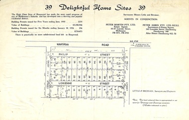
Flyer, Subdivision advertisement for sale of home sites - Ringwood, Victoria - 1956
Cardboard-backed advertisement for 39 home sites for sale, with location map, and summary of local real estate statistics in 1955 & 1956. Handwritten date noted in top right corner - 24th March, 1956.Subdivision map includes Reilly Street, Philip Street, Lorienne Street and Daisy Street in Heathmont. Surveyors: Messrs Little and Brosnan. Agents in conjunction: Peter Martin Pty. Ltd., Estate Agents, 55-57 Latrobe Street, Melbourne (Phone) FB 3571, FB 2783, and Peter Aubin Pty. Ltd., Auctioneers & Estage Agents, 345 Lonsdale Street, Dandenong (Phone) Dandenong 340, after hours Dandenong 932, 70. -
![Map, Late the Property of Robert Lawson Esq. [Landsberg Estate Blackwood]](/media/collectors/5e461d8021ea67224c82f2a1/items/67763722eb6d2cbd24dff14f/item-media/677637b7eb6d2cbd24dff29d/item-fit-380x285.jpg) Bacchus Marsh & District Historical Society
Bacchus Marsh & District Historical SocietyMap, Late the Property of Robert Lawson Esq. [Landsberg Estate Blackwood]
The date this map was created has not been identified. It was possibly created at the time the Landsberg Estate near Blackwood was subdivided and sold into smaller lots in December 1886. This land once belonged to Robert Lawson who died in 1869. Lawson was a well known school teacher who founded Scotch College in Melbourne before setting up a school near Blackwood. This map is similar to another map in the BMDHS collection titled 'Landsberg Estate Blackwood' Victorian Collections record 459 and was possibly produced at the same time.Single page map showing land allotments which made up the Landsberg Estate near Blackwood. Scale 20 chains to 1 inch. The map is pasted into a bound volume containing 76 maps or plans in total. High resolution digital image stored on BMDHS computer network. At the top of the map: 'Late the Property of Robert Lawson Esq.'bacchus marsh victoria maps, landsberg estate blackwood -
 City of Moorabbin Historical Society (Operating the Box Cottage Museum)
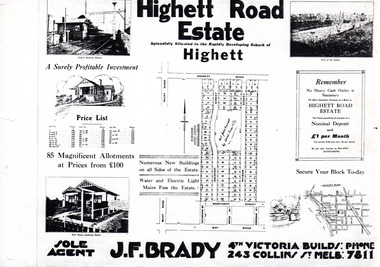
Flyer - Highett Road Estate, Highett
With the growth of Melbourne the market gardens were subdivided into building blocks as the land was worth more than the value of the crops.Example of the progress of the Municipality of MoorabbinPhotocopy of advertisement of private sale of housing lots in Highett.Highett Road Estate, Highett - 85 Magnificent Allotmentshighett road, wilson st, dalmont street, highett, real estate -
Clunes Museum
Certificate, SWAINSON FAMILY, STATEMENT OF RECEIPTS AND EXPENDITURE
CERTIFICATE OF ESTATE FROM THE SWAINSON FAMILY HOME IN HILL STREET, CLUNES. THAT BEING SALE OF ASSET/S, LAND AND DWELLING, BEING ALLOTMENT 11, SECTION 6, TOWNSHIP OF CLUNES, PARISH OF CLUNES, COUNTY OF TALBOT. SOLD TO MRS. C.K. BUCHANAN. 1918-1919PHOTOCOPIES OF: .1 THE BALLARAT TRUSTEES EXECUTORS & AGENCY COMPANY LIMITED. STATEMENT OF RECEIPTS & EXPENDITURE FOR AND ON A/C OF ESTATE OF JOHN SWAINSON DECEASED DATED 23/9/1919 .2 & .3 PHOTOCOPIES OF THE BALLARAT TRUSTEES EXECUTORS & AGENCY COMPANY LIMITED. ESTATE OF JOHN SWAINSON DECEASED DATED 23/9/1919 .4 COVER LETTER FROM THE BALLARAT TRUSTEES EXECUTORS & AGENCY COMPANY LIMITED TO MRS. L.E. SWAINSON WIDOW OF JOHN SWAINSON DATED 17/10/1918 CHEQUE IN THE AMOUNT OF 93 POUNDS, 19 SHILLINGS AND ZERO PENCE IN LIEU OF THE SIGNED RELEASE.NILlocal history, certificates, swainson family, mrs. c k buchanan -
 Hume City Civic Collection
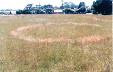
Photograph, early 1990's
This is one of a series of Aboriginal rings which are found in the Sunbury area. The former Shire of Bulla published a detailed study of the Aboriginal Ring sites in the early 1990's.A coloured photograph of a sacred site featuring an Aboriginal ring within the Sherwood Housing Estate. There is a cleared grassed area with a distinctive ring in the foreground with the housing estate in the background.sherwood estate, aboriginal ring sites, george evans collection -
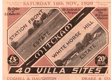 Whitehorse Historical Society Inc.
Pamphlet, Auction - Station Front Estate & Whitehorse Hill Estate
Sale of Station Front Estate and Whitehorse Hill estateSale of Station Front Estate and Whitehorse Hill estate 16/11/1929. 4o villa sites - 20/- per lot, per month, L3 depositSale of Station Front Estate and Whitehorse Hill estate station front estate, whitehorse hill estate, walker, edgar edwardes, coghill & haughton, drake & co., calcutta street, mitcham, simla street, benares street, delhi street, mitcham road, esplanade, barkly terrace, madden & candy, solicitors -
Whitehorse Historical Society Inc.
Newspaper - Advertisement, Bellevue Hill, 1971
Newspaper cutting advertising sale of Bellevue Hill Estate, East Burwood in 1971. Comprising 113 home sites. Estate bordered by Mahoneys Road and Springvale Roadland subdivision, land sales, development underwriting pty. ltd., mahoneys road, burwood east, springvale road, the sun property guide -
 Kew Historical Society Inc
Photograph - W.B. Villa, Kew, c.1919
The photograph offers significant information relating to late Victorian / Federation colour schemes and fencing.The block fronted villa has a corrugated iron roof and a flat projecting verandah, ornamented with a trellis design of timber. The front window features a timber shade, mounted on brackets. The treatment of the block-fronted panels shows that there is an attempt to highlight imitation quoining through use of a darker colour. The windows and door are also in this darker shade. The front fence and gate are made of wooden pickets. It is unlikely that the photograph was taken at the time of the villa's construction given the size of the shrub/tree in the front garden.Subdivision plans are historically important documents used as evidence of the growth of suburbs in Australia. They frequently provide information about when the land was sold on which a built structure was subsequently constructed as well as evidence relating to surveyors and real estate and financial agents. The numerous subdivision plans in the Kew Historical Society's collection represent working documents, ranging from the initial sketches made in planning a subdivision to printed plans on which auctioneers or agents listed the prices for which individual lots were sold. In a number of cases, the reverse of a subdivision plan in the collection includes a photograph of a house that was also for sale by the agent. These photographs provide significant heritage information relating house design and decoration, fencing and household gardens.A real estate photograph, mounted on brown card, showing a double fronted weatherboard villa, located in Kew, Victoria. On the reverse of the photograph is a subdivision plan for the Altyre Estate.Stamped on mount: Top - "KEW. Close tram. Fine View. / W.B. Villa Containing 8 Rooms. / Up-to-date Conveniences. EL Etc." Below - "Land 40 x 165. 615 pounds. Sold"houses - kew, real estate photographs -
 City of Kingston
Pamphlet - Black and white, Stott & Burke, Highland Estate Bentleigh, c.1915
Sales plan for land in the suburb of Bentleigh, along Collins and Ross Streets, bounded by Jasper Road.The developing urban area of Bentleigh within the City of Kingston. This land sale pamphlet illustrates the subdivision of land within the municipality and the changing demographic of the district as new houses are constructed.Black and white pamphlet advertising for private sale the Highland Estate, Bentleigh. Incorporates a map of the estate between Collins St and Ross St, bordered by Japser Road. Handwritten in grey pencil on map: additional subdivisions numbered 15-19 drawn along Ross St Handwritten in grey pencil on map: indecipherable annotations to subdivisions 1, 3 and 14land sales, bentleigh, estate