Showing 996 items
matching hand painted
-
 Bendigo Historical Society Inc.
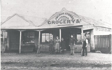
Photograph - HARRY BIGGS COLLECTION: ANCHOR STORES MOORHEAD BROS
... on the gables of the buildings. Above the verandah on the right hand... on the gables of the buildings. Above the verandah on the right hand ...Photograph of a double fronted wooden shop front with a verandah across the whole width. There is decorative fretwork on the gables of the buildings. Above the verandah on the right hand side is a painted sign Anchor Stores, Moorhead Bros. Grocery &c. In front of the verandah there are three women and two men. The name 'Moorhead Bros.' is also on a sign at the side of the verandah. This store is in Sailors Gullybuildings, commercial, anchor stores, anchor stores, moorhead bros, sailors gully -
 Glenelg Shire Council Cultural Collection
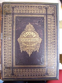
Book - Bible, Reverend John Brown, Brown's Self-Interpreting Family Bible, n.d
... edges to front and back cover. Gold paint and hand-coloured... edges to front and back cover. Gold paint and hand-coloured ...Large bible. Leather bound with brass clasps engraved with a decorative pattern. Gold decorations on front cover, on spine, and a gold decorative border on back cover with embossed pattern in centre. Cover bears words "THE HOLY SCRIPTURES WHICH-MAKE-WISE UNTO SALVATION", within a decorative pattern. Incised brass edges to front and back cover. Gold paint and hand-coloured decorative title page. (see Object File).bible, religion -
 Mont De Lancey
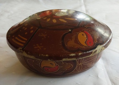
Container - Lidded Container, c1920
... and lid has patterns painted by hand in yellow and red of a bird... patterns painted by hand in yellow and red of a bird, ying and yang ...Used for storing various threads for mending in the home - cotton, silk, wool nylon.A decorated brown lidded round container coated inside with black and brown type lacquer. The outside of the container and lid has patterns painted by hand in yellow and red of a bird, ying and yang symbols and oriental script all surrounded in black lined sections. It appears to be made from papier-mache which is layers of cardboard glued together and tightly compressed. This can be seen by the damage sections which grey cardboard shows though. It would have been lacquered over and painted. The container has a variety of sewing items and mending threads for stockings, socks and other work. Some pearl buttons included.As mentioned above, the container has various patterns painted on it. The sewing items include brands of threads for sewing work - Darneezi, Eagley, Rite Tone, Clark's Filosheen,Chadwick's Wool and Nylon, Nylusta.sewingcontainer, threads, containers, sewing equipment, gibson collection -
 Flagstaff Hill Maritime Museum and Village
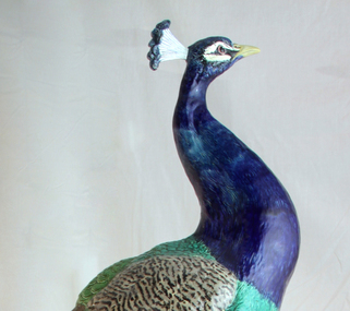
Decorative object - Peacock, Minton Majolica life-size model, Paul Comolera, artist, Designed: c. 1873; Made: c. 1875
... earthenware model, which was then hand painted in brilliantly coloured... earthenware model, which was then hand painted in brilliantly coloured ...This majestic peacock embodies the technical achievement, skill and ingenuity of artisans during the 19th century. It is now known as the 'Loch Ard Peacock' and was designed and modelled in 1873 by Paul Comolera (1818-1897) and fired in one piece at the Minton factory at Stoke-on-Trent in the United Kingdom in 1875. The peacock has been portrayed in symbolic motifs and has figured heavily in folktales and fables since antiquity, and many cultures around the world see it as a symbol of beauty, rebirth and power. Wealthy Victorians loved majolica, and the large peacock would have been the ultimate home accessory as a conservatory ornament – combining their desire for nature, the exotic and vibrant colours. The peacock model was listed in catalogues by Minton & Co. for a retail price of 35 guineas or sold as a pair for 90 guineas. Minton & Co. was founded in 1793 by Thomas Minton (1765–1836) and became a famous pottery and porcelain manufacturer. Comolera was a French artist and sculptor, renowned for dramatic naturalistic forms and life-size renditions of birds and animals that won him admiration in public and artistic circles. He was employed by Minton & Co. from 1873 to 1880, and the life-sized peacock became his best-known work. Comolera kept a live peacock loaned from the nearby Duke of Sutherland's Trentham Hall Estate in his studio to create a life-size model of fine buff earthenware model, which was then hand painted in brilliantly coloured green and blue glazes to mimic the peafowl’s dazzling plumage. There are no surviving production records, but according to documents in the Minton Archive, nine peacocks were made by Comolera. However, today, some historians now believe that twelve were fired at the Minton factory; research is ongoing. These peacocks were so admired that Minton & Co. used them as exhibition showpieces at International Exhibitions in London, Paris, and the United States of America, ensuring the company had a worldwide reputation. So, when Melbourne hosted an International Exposition in 1880, Minton & Co. sent out ceramics and tiles, and in particular, this peacock was intended to be part of their exhibit in the British Court in the Exhibition Building, built in the Carlton Gardens. The early dispatch date (1878) indicates that the company may have intended to exhibit their wares, including the peacock, at the 1879 Sydney International Exhibition, but the company did not take up this option. The ship that Minton & Co. used to bring the peacock and their other wares to the Australian colonies was the ill-fated Loch Ard, which sunk after striking Mutton Bird Island near Port Campbell, Victoria, in calm foggy weather in June 1878 on the final leg of the ship's journey to Melbourne. The loss of 52 lives made it one of Victoria’s worst shipwrecks. Therefore, this peacock never made it to the grand exposition in Melbourne, as Minton & Co. had planned. Charles McGillivray dragged this peacock, still in its original packing case, onto the beach in the gorge just two days after the Loch Ard went down. The peacock was rescued unscathed apart from a chip on its beak (only repaired in 1988). After a disagreement with a Melbourne Customs Officer, Joseph Daish, McGillivray stopped his salvage operations, leaving the peacock on the beach. The second salvagers were James Miller and Thomas Keys. Miller was a member of the firm Howarth, Miller and Matthews, Geelong, who had brought the salvage rights to the Loch Ard wreck on 10 June. When Miller and Keys arrived at the wreck site, a storm had washed many of the salvaged goods, including this peacoc,k back into the sea. The two men found the peacock in its case ‘bobbing along in the water’ and pulled it back to the beach. To ensure the peacock wasn't washed out to sea again, Miller and Keys hauled the packing case containing the peacock up the gorge's cliff face to the top, ready to be transported. In an interview in 1928, Keys claimed that at the time of the rescue, the head had broken from the body. This account was proven to be true in 1988, following the birds' display in Brisbane. This peacock began its life in Australia, not in the grandeur of an International Exhibition as intended, but in the hallway of a simple domestic house in Geelong. It appears Minton & Co. did not attempt to buy this peacock back. Florence Miller, daughter of James Miller (Loch Ard salvage rights holder), later remarked that the only item of real value rescued from the wreck had been the peacock and that this had been kept by her father in the family home at Malvern for many years and became a treasured family possession. As such, this 'Loch Ard peacock' was almost forgotten and mistaken with other Minton peacocks around the world. Miss Florence Miller tried to sell the peacock due to financial difficulties in the 1930s but was unsuccessful. While attempting to sell her Loch Ard relic, it was displayed in the window of the old Argus newspaper office, which was at 76 Collins Street, Melbourne; the Argus had relocated to the corner of Elizabeth and La Trobe Streets in 1926. Between 1935 and 1939, the old Argus building was occupied by the Joshua N. McClelland Print Room, which sold not only paintings and prints but also antiques and authentic replicas, as well as hosting exhibitions. Miss Florence Miller loaned her peacock for display at the Victorian Historical Exhibition held in the National Gallery on 1st June 1935, the 57th anniversary of the Loch Ard wreck. As a result, the peacock attracted public attention in books, newspapers and magazine articles that told the story of its survival from a shipwreck. Miss Florence Miller was keen to sell the peacock, even writing overseas to Captain Blain on November 30th, 1938, about the possibility of a sale, but this became no longer possible due to the outbreak of war. Recent information points to the Loch Ard peacock being owned by John S R Heath before its sale to Frank Ridley-Lee in May 1941. Research is ongoing, but it seems likely that John Samuel Robert Heath, a leading Melbourne dentist with a practice in Collins Street, and his wife, a dental mechanic, had purchased Miss Miller’s Loch Ard peacock before its sale in 1941. They were lovers of fine arts, music, wine and food. The peacock in the window of the old Argus building could have attracted their attention as they had already purchased the old stone Presbyterian Church on Warrigal Road, Oakleigh, in 1933 and had converted its interior. The home, renamed The Studio, even included Melbourne’s first all-electric kitchen. The peacock was perfect for display in the Studio’s entrance. A magazine article published after the conversion was completed included photographs of the interior. The picture of the ‘portico’ had a caption below that stated, “Some of her [Mrs Heath’s] finest pottery was salvaged from the Loch Ard Wreck”. In 2025, Heath’s two remaining sons remember running around in the entrance with the peacock standing there, oblivious to its value. Heath was an accomplished artist, studying under Max Meldrum. He painted and exhibited his works at The Studio and in a public exhibition, and he was a finalist eight times in the coveted Archibald Prize portrait competition, including the submission of his self-portrait that is now part of his grandson’s collection. The next owner of the Loch Ard Peacock was Frank Ridley-Lee. He displayed it at his home in Ivanhoe after buying it at an auction in May 1941. The peacock remained in the hands of the Ridley-Lee family until it was offered for sale by auction in 1975 as part of an art collection belonging to Mrs Ridley-Lee's estate. The peacock was not sold at this time, as the reserve price of $4500 was not met. This news was passed on to the board of the newly created Flagstaff Hill Maritime Village. Urgent efforts were made to collect the necessary money through fundraising by the Warrnambool City Council and public donations. The Fletcher Jones Company and the Victorian Government contributed half the cost. On 9 September 1975, the Loch Ard peacock was purchased by Flagstaff Hill Maritime Village, and it found a new home at the maritime museum. Since then, it has only left Warrnambool twice. Firstly, in 1980, at the centenary celebrations of the Royal Exhibition Building in Melbourne, and secondly, in 1988, the peacock was given pride of place at the entrance to the Victorian Pavilion at the Brisbane World Expo, acknowledging that this Minton Majolica peacock is the most significant shipwreck object in Australia. The Minton majolica peacock is considered of historical social and aesthetic significance to Victoria and is one of only a few 'objects' registered on the Victorian Heritage Register (H 2132), as it is a most notable and rare object associated with the Minton factory of the 1870s and works by the celebrated sculptor Paul Comolera along with the wreck of the Loch Ard on the Victorian coastline. This Minton peacock is historically significant for its rarity; it was one of only 9-12 known to exist. The shipwreck of the Loch Ard is also of significance for Victoria and is registered on the Victorian Heritage Register Ref (S 417). Flagstaff Hill has a varied collection of artefacts from Loch Ard and its collection is significant for being one of the largest accumulation of artefacts from this notable Victorian shipwreck. The collections object is to also give us a snapshot into history so we can interpret the story of this tragic event. The collection is also archaeologically significant as it represents aspects of Victoria's shipping history that allows us to interpret Victoria's early social and historical themes. The collection is historically significant is that it is associated, unfortunately with the worst and best-known shipwreck in Victoria's history. The peacock, resplendent in polychrome glaze, stands perched on a rocky plinth decorated with vines, leaves, flowers, blackberries and wild mushrooms. The peacock’s breast is cobalt blue; the wings and legs are in naturalistic colours. The tail is a mass of feathers coloured in green, ochre blue and brown — a fantastic display of artistry and Minton expertise. Inscribed at the base :P Comolera, and a Minton & Co. design number: 2045.flagstaff hill, warrnambool, maritime museum, shipwreck coast, loch ard, loch ard gorge, peacock, paul comolera, victorian heritage register, minton peacock, minton & co., stoke upon trent, bird figures, mintons, ceramics, international expositions, majolica, naturalistic, staffordshire, john samuel robert heath -
 Melbourne Tram Museum
Album - Photographs - Comeng Dandenong, 1980s - 1990s
... if this was originally painted in this livery (incorrectly) or if this was one... if this was originally painted in this livery (incorrectly) or if this was one ...In March 2024, Milissa Box (DTP) was at a trash and treasure market. She'd found a $5 photo album for sale with some photos that she thought might be of interest… From what I can gather it belonged to the gentleman pictured who was a worker at Dandenong in the Comeng and ABB eras. He appears to have worked on the Z3, A1/A2, B1/B2 class trams, Hong Kong LRVs, Comeng Melbourne suburban trains, and later the extra Victorian-purchased XP power cars and XAM sleepers to enable the Riverina XPT to be extended to Melbourne. It's clear he was very proud of the vehicles he'd helped to build. I have scanned a selection of the images, which appear to be a mix of official builder's portraits, team photos, and self-taken shots showing candid everyday scenes on the shop floor. There are also images of the launch of the XP power cars with then-Victorian Premier Joan Kirner; and some personal visits to see the Flying Scotsman, Victorian Goldfields Railway, Coal Creek, etc. Filename Description Date Comeng Scans 2024-03-05 0001 Three Comeng workers (including the photographer) stand in front of Comeng suburban train 697M (Chopper unit) c. June-July 1989 Comeng Scans 2024-03-05 0002 Three Comeng workers (including the photographer) stand in front of Comeng suburban train 697M (Chopper unit) c. June-July 1989 Comeng Scans 2024-03-05 0003 Hong Kong Light Rail Phase 1 LRV 1013 being lifted onto its transport loader c. 1987-88 Comeng Scans 2024-03-05 0004 Walter Wright transport truck (Mack) waits to draw a heavy transport platform out of a shed at Comeng Dandenong. Hong Kong Phase I LRV (1024) can be seen inside the shed c. 1988 Comeng Scans 2024-03-05 0005 Hong Kong Light Rail Phase 1 LRV 1013 on its transport loader in a shed at Comeng Dandenong ready for transport c. 1988 Comeng Scans 2024-03-05 0006 Hong Kong Light Rail Phase 1 LRV 1013 on its transport loader in a shed at Comeng Dandenong ready for transport c. 1988 Comeng Scans 2024-03-05 0007 The photographer is pictured fitting components to the cab of a Phase I Hong Kong LRV No 1026 c. 1988 Comeng Scans 2024-03-05 0008 Hong Kong Light Rail Phase 1 LRV 1013 on its transport loader at Comeng Dandenong ready for transport c. 1988 Comeng Scans 2024-03-05 0009 Hong Kong Light Rail Phase 1 LRV 1013 on its transport loader at Comeng Dandenong ready for transport c. 1988 Comeng Scans 2024-03-05 0010 Hong Kong Light Rail Phase 1 LRV 1013 on its transport loader at Comeng Dandenong ready for transport c. 1988 Comeng Scans 2024-03-05 0011 The photographer and a colleague are pictured in the car park posing for a photo at Comeng Dandenong c. 1988 Comeng Scans 2024-03-05 0012 The photographer and a colleague are pictured inside the cab of Comeng suburban train 697M, posing for a photo at Comeng Dandenong c. 1989 Comeng Scans 2024-03-05 0013 A stainless steel Hitachi train bodyshell is being transported on a truck-trailer. Possibly taken at Martin and King in Bayswater, under transport to the station for railing to Somerton for fitout. This is a later series M car with the rear-mounted pantograph (note the mounting lugs above the non-driving end) c. 1980 Comeng Scans 2024-03-05 0014 A shot at Comeng Dandenong of the onsite workforce standing in front of a Phase I Hong Kong LRV. c.1987-88 Comeng Scans 2024-03-05 0015 A shot at Comeng Dandenong of the onsite workforce standing in front of a Phase I Hong Kong LRV. c.1987-88 Comeng Scans 2024-03-05 0016 Hong Kong Light Rail Phase 1 LRV 1038 on its transport loader at Port of Melbourne ready for transport c. 1988 Comeng Scans 2024-03-05 0017 Three Comeng workers (including the photographer) stand in front of a workbench at Comeng Dandenong c. June-July 1989 Comeng Scans 2024-03-05 0018 A newly completed Comeng train (wearing VicRail teacup orange) on the factory access track at Comeng Dandenong c. 1981 Comeng Scans 2024-03-05 0019 A newly completed Z3 class tram on a transporter, with its bogie frames waiting transport to Preston Workshops for final fitout and commissioning c. 1981 Comeng Scans 2024-03-05 0020 A newly completed Comeng train (wearing VicRail teacup orange) on the factory access track at Comeng Dandenong c. 1981 Comeng Scans 2024-03-05 0021 A newly completed Z3 class tram on a transporter, with its bogie frames waiting transport to Preston Workshops for final fitout and commissioning c. 1981 Comeng Scans 2024-03-05 0022 A Comeng/ABB artist impression presumably part of their bid for the Double Decker demonstrator train for Melbourne. Note the similarity to similar Comeng sets constructed for Sydney. c. Nov 1989 – April 1990 Comeng Scans 2024-03-05 0023 Victorian Railways steam locomotive K 169 on static display at Coal Creek. c. 1980s Comeng Scans 2024-03-05 0024 Comeng suburban train carriage 1190T on a traverser in the yard at Comeng Dandenong. c. June-July 1989 Comeng Scans 2024-03-05 0025 Comeng suburban train carriages the yard at Comeng Dandenong. c. June-July 1989 Comeng Scans 2024-03-05 0026 Comeng suburban train carriages the yard at Comeng Dandenong. c. June-July 1989 Comeng Scans 2024-03-05 0027 Comeng suburban train carriages the yard at Comeng Dandenong. c. June-July 1989 Comeng Scans 2024-03-05 0028 Comeng suburban train carriages the yard at Comeng Dandenong. c. June-July 1989 Comeng Scans 2024-03-05 0029 Comeng suburban train in a shed at Comeng Dandenong. c. June-July 1989 Comeng Scans 2024-03-05 0030 Comeng suburban train carriage 1190T on a traverser in the yard at Comeng Dandenong – possible Factory Acceptance Inspection by the Met c. June-July 1989 Comeng Scans 2024-03-05 0031 Comeng suburban train carriage 1190T being tractor-shunted in the yard at Comeng Dandenong – possible Factory Acceptance Inspection by the Met c. June-July 1989 Comeng Scans 2024-03-05 0032 Two Comeng workers carry a train part (possibly a first aid kit) for fitting to a Comeng suburban train. c. June-July 1989 Comeng Scans 2024-03-05 0033 Comeng suburban train carriage 1190T on a traverser in the yard at Comeng Dandenong – possible Factory Acceptance Inspection by the Met. One of the Met staff appears to be giving one of the Comeng workers a kiss on the cheek. c. June-July 1989 Comeng Scans 2024-03-05 0034 A B2 Class tram is on a low-loader multiwheel transport trailer waiting transport to Preston Workshops; while what appears to be a classic AP6 Valiant Safari Wagon is in the foreground. c. June-July 1989 Comeng Scans 2024-03-05 0035 A B2 Class tram is on a low-loader multiwheel transport trailer waiting transport to Preston Workshops; while a worker poses for a photo with his hand on the rigging. c. June-July 1989 Comeng Scans 2024-03-05 0036 A B2 Class tram is on a low-loader multiwheel transport trailer waiting transport to Preston Workshops; An HT Holden Belmont sedan has been posed in front to appear as if it is towing the heavy vehicle. c. June-July 1989 Comeng Scans 2024-03-05 0037 A B2 Class tram is on a low-loader multiwheel transport trailer waiting transport to Preston Workshops; An HT Holden Belmont sedan has been posed in front to appear as if it is towing the heavy vehicle. c. June-July 1989 Comeng Scans 2024-03-05 0038 A1 Class tram 232 is pictured up on stands while various A/B class tram cab frames are in the foreground in various stages of assembly. Of note, 232 appears to have been returned to Dandenong for major repair or other work, and shows signs of having been in traffic for some time (weathering and wear) c. June-July 1989 Comeng Scans 2024-03-05 0039 various A/B class tram cab frames are in the foreground in various stages of assembly. c. June-July 1989 Comeng Scans 2024-03-05 0040 A group of Comeng Dandenong workers stopped on a tea break. c. June-July 1989 Comeng Scans 2024-03-05 0041 An A/B Class tram cab being fitted out with electronics and controls. c. June-July 1989 Comeng Scans 2024-03-05 0042 A new Comeng suburban train in Metropolitan Transit livery on the test track at Comeng Dandenong. c. mid 1980s Comeng Scans 2024-03-05 0043 A new Comeng suburban train in Metropolitan Transit livery on the test track at Comeng Dandenong. c. mid 1980s Comeng Scans 2024-03-05 0044 Interior shot of a new Comeng suburban train at Comeng Dandenong. c. mid 1980s Comeng Scans 2024-03-05 0045 Interior shot of a new Comeng suburban train at Comeng Dandenong. c. mid 1980s Comeng Scans 2024-03-05 0046 The exterior sign at Dandenong showing ABB brand. Early 1990s Comeng Scans 2024-03-05 0047 A B2 Class tram is on a low-loader multiwheel transport trailer waiting transport to Preston Workshops. Early 1990s Comeng Scans 2024-03-05 0048 The Brush generator and Paxman Valenta engine as fitted inside a new XP power car for NSW Countrylink (paid for by Victoria) c. 1992 Comeng Scans 2024-03-05 0049 An exterior shot of a new Countrylink XP power car for NSW under construction (paid for by Victoria) c. 1992 Comeng Scans 2024-03-05 0050 Two new XAM class XPT sleeper carriages under construction at Comeng Dandenong c. 1992 Comeng Scans 2024-03-05 0051 A B2 class tram under construction at Comeng Dandenong Early 1990s Comeng Scans 2024-03-05 0052 A B2 class tram under construction at Comeng Dandenong Early 1990s Comeng Scans 2024-03-05 0053 An exterior shot of a new Countrylink XP power car for NSW being moved out of the shed c. 1992 Comeng Scans 2024-03-05 0054 An exterior shot of a new Countrylink XP power car at Comeng Dandenong c. 1992 Comeng Scans 2024-03-05 0055 An exterior shot of a new Countrylink XP power car at Comeng Dandenong c. 1992 Comeng Scans 2024-03-05 0056 An exterior shot of a new Countrylink XP power car at Comeng Dandenong c. 1992 Comeng Scans 2024-03-05 0057 B2 class trams under construction at Comeng Dandenong Early 1990s Comeng Scans 2024-03-05 0058 An XP Powercar from NSW wearing the Intercity XPT Candy Livery at Comeng Dandenong. It is not known if this was originally painted in this livery (incorrectly) or if this was one of the first delivered series transported to Dandenong to aid the construction process of the four additional locomotives. Early 1990s Comeng Scans 2024-03-05 0059 Melbourne B2 Class tram B2.2100 (renumbered from 2102) painted in the distinctive Chocolate and Cream livery to mark the completion of 100 B2 class trams Early 1990s Comeng Scans 2024-03-05 0060 A factory forklift wearing a hand painted “We love Labo(u)r” cardboard sign, possibly in connection to a media event with the Victorian Premier onsite at Comeng Dandenong. c. 1992 Comeng Scans 2024-03-05 0061 An exterior shot of a new Countrylink XP power car at Comeng Dandenong c. 1992 Comeng Scans 2024-03-05 0062 Two new new Countrylink XP power cars under construction and final fitout at Comeng Dandenong c. 1992 Comeng Scans 2024-03-05 0063 An exterior shot of a new Countrylink XP power car on the traverser at Comeng Dandenong c. 1992 Comeng Scans 2024-03-05 0064 A B2 Class tram is on a low-loader multiwheel transport trailer waiting transport to Preston Workshops. A large banner is draped on the side explaining that this is the 106th vehicle delivered to the Public Transport Corporation (B2.2108). c. Oct 1992 (based on delivery date) Comeng Scans 2024-03-05 0065 Victorian Premier Joan Kirner addresses a group of dignitaries in front of an ABB banner inside the main administration building at Dandenong, on the occasion of the first XPT power car purchased by Victoria being unveiled at a media event c. 1992 Comeng Scans 2024-03-05 0066 An ABB executive addresses a group of dignitaries in front of an ABB banner inside the main administration building at Dandenong, on the occasion of the first XPT power car purchased by Victoria being unveiled at a media event c. 1992 Comeng Scans 2024-03-05 0067 Victorian Premier Joan Kirner addresses the media in front of a completed XP class XPT power car at Dandenong, on the occasion of the first XPT power car purchased by Victoria being unveiled at a media event c. 1992 Comeng Scans 2024-03-05 0068 An exterior shot of a new Countrylink XP power car at Comeng Dandenong c. 1992 Comeng Scans 2024-03-05 0069 A Melbourne B2 class tram undergoing testing on the test circuit at ABB Dandenong c. early 1990s Comeng Scans 2024-03-05 0070 An XPlorer type DMU emerges from a shed at ABB Dandenong c.1994 Comeng Scans 2024-03-05 0071 Voith final drive axle mounted units for XPlorer railcars waiting to be fitted at Dandenong. c.1994 Comeng Scans 2024-03-05 0072 A completed XAM class sleeper carriage at ABB Dandenong. c.1993 Comeng Scans 2024-03-05 0073 Completed XPlorer railcars wait transfer to South Dynon for bogie exchange and transfer to NSW at ABB Dandenong. c. 1994 Comeng Scans 2024-03-05 0074 A clipping from an ABB internal newsletter outlining the staff-led initiative to commemorate the 100th B2 class tram with a special livery c.1992 Has photographs of ABB, Steamrail tours, Castlemaine and Maldon Railway, Fying Scotsman 4472 visit and Puffing Billy.Yields information about the people and events at Commonwealth Engineering plant Dandenong and the activities of the unknown compiler.Album containing 40 leaves, photos in a heavy card 3 ring spring binder.comeng, commonwealth engineering co., tramcars, hong kong, nsw, sydney, melbourne, railways, the met, b class, cmr, steam engines, abb, asea brown boveri -
 The Beechworth Burke Museum
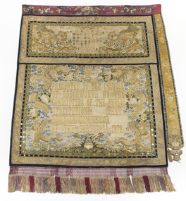
Textile - Banner, c1872
This banner was one of five banners gifted to the Beechworth Chinese community in recognition of their support of the Hospital and Benevolent Asylum in 1875, from the Carnival Committee. These banners had been purchased in China by a social envoy from Beechworth then presented to the Chinese community during the Beechworth Fine Arts Exhibition in May of that same year, by Donald Fiddes, President of the Ovens District Hospital. The Burke Museum's Chinese Collection presents the history of Chinese settlement in Beechworth from 1856 and its involvement in local community affairs in the second half of the 19th century. In settling in the area they formed their own community with distinctive Chinese cultural traditions, forming their own 'camps' with laid out streets, housing a Temple, Chinese Theatre and restaurants, hotels, stores, gambling houses and dwellings. Members of the Chinese community took an active interest in town affairs and were generous donors to the appeal to build the Ovens District Hospital in 1856/7. The vibrant colours and dynamic graphics of the silk embroidered Chinese banners were a highlight of Beechworth Charitable processions that took place in the main street. Two of the Chinese banners were conserved for the Burke Museum in 2006 by Carol Campbell of Phoenix Conservation Services with funding from Victoria’s Heritage Grants. In 2015, with the enormous support of the Copland Foundation and fundraising activities by the Friends of the Bur Museum Committee, conservation of the third banner was undertaken by Artlab Australia in Adelaide.The banners display traditional Chinese textile techniques and are visually beautiful and very rare and are considered of local and national significance, with the potential to be deemed internationally significant.The banner has a narrow fuchsia embroidered top border, a wider embroidered panel depicting 2 dogs with embroidered Chinese text and a larger lower panel with the embroidered text “PRESENTED TO THE CHINESE OF BEECHWORTH BY THE COMMITEES OF THE PUBLIC INSTITUTIONS (missing) THAT TOWN IN COMMEMOR (missing) OF THE CARNIVAL 1873” The 2 lower panels have narrow decorative borders decorated with mirrors and extensive embroidery. There is an additional embroidered tab running along the right hand edge. The bottom edge has a wide knotted fringe. The back is lined with fabric decorated with a painted scene. Refer Attachment 1 quote ARTLAB AustPRESENTED TO THE CHINESE / OF BEECHWORTH BY THE / COMMITEES OF THE PUBLIC / INSTITUTIONS THAT / TOWN IN COMMEMOR / OF THE CARNIVAL 1873beechworth, burke museum, chinese, benevolent asylum, ovens district hospital, beechworth carnival processions, carnival, processions, beechworth chinese community, beechworth fine arts exhibition, donald fiddes -
 Orbost & District Historical Society
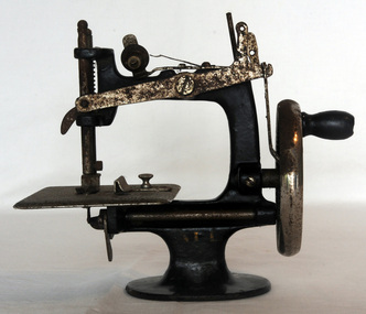
sewing machine, C 1920's
This machine was given to Ada Healey as a child. Ada Healey was for 20 years a volunteer and organizer at the Orbost Slab Hut (Orbost Information Centre). She was known for her craft skills and was a particularly fine knitter. Ada was the only child of Tom & Queenie Warne, born in Bombala/Delrgate. She was married to Keith Healey. The Healey family were early settlers in Marlo.This is an example of a toy given as a "teaching" toy. It was used by its owner to practise sewing before graduating to an adult type machine.A small hand-operated sewing machine. The body of the sewing machine is painted black. The top arm appears to have been painted in a white/cream colour. The machine could have been used to make small articles. There is no bobbin.On the stand- A.L.L.sewing handcraft toy toy-sewing-machine -
 Orbost & District Historical Society
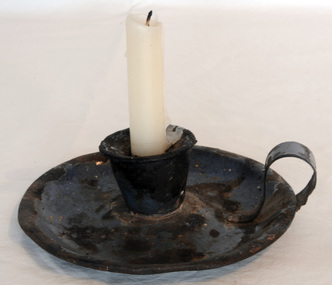
candlestick holder, C 1880 - 1920's
Portable candleholders were commonly in use in Australian homes in the 1800s. Candles were very expensive in Australia and often were not available in stores. However, after 1850 the price of candles was reduced and they became readily available throughout Australia. Candleholders were popular as they protected furniture from hot wax. The dish around the candle stem collected the hot wax that could be reused later. When carrying the candleholder, the dish also protected the hand from the hot wax. This candle-holder is an example of an item commonly used before electricity was connected to the area.The candleholder is a hollowed round,saucer-shape with a ring finger-grip on the side. It has been enamelled but the original blue paint has worn off and it is very chipped and rusted.candlestick-holder lighting -
 Orbost & District Historical Society
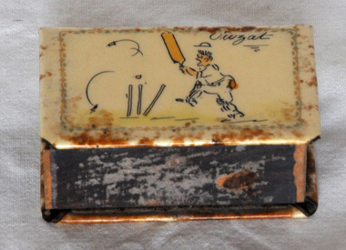
match box cover, 1950-1960's
This was owned and used by J.G. Ralston of Orbost. John Gavin Ralston was born 26 July 1914 at Eden, N.S.W. and came to Orbost in the early 1920's, with his parents and siblings. They lived at the corner of Tennyson and Salisbury Streets. Jack was educated at Orbost Higher Elementary School before being apprenticed to William Ross at the Snowy River Mail as a lino-type operator. He married Jean Cameron. After WW11 when he served overseas in the islands) He resumed his trade at the Snowy River Mail until 1949 when began J.G.& J.M. Ralston, Seed & Produce Merchants. Jack Ralston was very involved in the Orbost sporting community, the Presbyterian Church and the Orbost Municipal Band. He also served in the Orbost sub-branch of the R.S.L. He died on April 15 1967. (ref. Margaret Smith O.D.H.S. Newsletter) Collecting match box holders / grips was a popular hobby. They were made to fit over a box of matches for protection. Some were especially produced for significant occasions. This item is an example of a very common personal item rarely used today.A painted metal matchbox cover with a thin wooden matchbox inside. It is cream coloured with a picture of a cricketer being bowled out. In the top right hand corner is "OWZAT". The matches are Bryant & May's Crown Safety Matches. it is a rectangular cardboard box with a sliding cardboard drawer. The box has a paper label with text reading, "BRYANT & MAY'S CROWN SAFETY MATCHES" and an image of a crown. The top and bottom side has a purple striking paper, to light match. Bottom and sides of sliding drawer are a green color.J.G.Ralstonmatchbox-holder smoking-accessories ralston-j.g. -
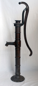 Orbost & District Historical Society
pump, late 19th -early 20th century
Hand operated water pumps were used to supply water prior to the widespread use of windmill pumps, electric pumps and city water systems. Usually an old pump was made from cast iron, wood or tin. Pumps were very important to people up through the 19th century as farm houses seldom had indoor plumbing with running water. These pumps were also used for outdoor irrigation or laundry purposes.Hand operated water pumps were important before indoor plumbing was adequate. An iron water pump - hand-operated by a lever to the side. A plunger moves up and down (missing). It has a spout and has been painted brown.pump-water irrigation rural -
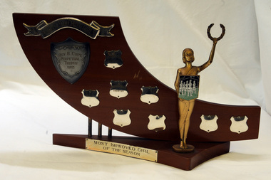 Orbost & District Historical Society
trophy
This is a perpetual annually presented trophy for the Orbost Marching Girls, the Waratahs. It was donated by local jeweller, Roy Cope.Together with a chaperone's blazer, a uniform and photos this trophy forms part of the history of the Orbost Marching Girls group.A wooden trophy with a triangular base and metal shields. It has a gold painted statue of a female with a laurel wreath in her outstretched left hand. In the right hand is a plaque with a team of marching girls on it.Orbost Marching Girls Roy B. Cope Perpetual Trophy 1963 Awarded to Helen Kelly 1963-64 Diane Bailey 1964-65 -
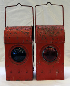 Orbost & District Historical Society
signal lamps
Possibly used in the Orbost district. Railway lamps of this kind were hand signalling lamps used by train guards, shunters and sometimes signalmen and station staff. They could signal the locomotive crew at night to let them know what to do (move forward/move backward/right-of-way) when leaving a station, goods yard or siding. Railway lamps of this kind were significant railway items in their period of use as essential tools to the safe-working operations of the railway. Two railway signal lamps. These are kerosene burning lamps made of metal and painted red. Both lamps have carrying handles at the top. .1 has a green glass lens and .2 has a red glass lens. signals lamps communication railway transport kerosene-burning -
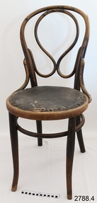 Flagstaff Hill Maritime Museum and Village
Chair, 1907-1914
The design of this set of four lightweight chairs is based on Thonet’s bentwood designs, which are still some of the best-selling designs for café and restaurant owners. It is elegant, sophisticated and durable. Some of these chairs still have their original seat, under which the letters “TH” or “RSL” are hand written. Flagstaff Hill has several bentwood chairs with these letters on them, in either chalk, black paint, or both. It is believed that the chairs were used in the original Warrnambool Town Hall, and later the RSL. The Town Hall was completed in 1891, built on the corners of Timor and Liebig Streets. (In 1977 the Town Hall was declared unsafe and was later replaced by the Warrnambool Performing Arts Centre.) Some of the chairs have marks, paper labels and symbols on them that show that the maker was Josef Jaworek, who had a small furniture factory in east Sinensia, which was at that time in Austria, from 1907 - 1914. Bentwood chairs are made by a process of wetting wood in water, bending it into curved shapes, then allowing it to dry so that the shape becomes permanent. This process originated by Michael Thonet, who had been given the right to bend wood into desired curves by the Austrian Courts in 1842. In 1856 he was granted a 13 year patent to manufacture chairs and table legs of bent wood treated by steam or boiling water. In 1859 his company Gebruder Thonet produced his original design. Thonet’s early designs also featured hand carved or laminated wooden seats. His Model No. 14 was produced in the 1850’s and his most popular design. After Michael’s death in 1871 the family went on designing and producing chairs. These bentwood chairs are believed to be associated with the original Warrnambool Town Hall. The Warrnambool Town Hall played a significant role in the both the local government and the social events of local and district areas. It was a place for Council meetings, community events and entertainment, theatrical and musical.Bentwood chair (4 of 4), painted black, inner back is curled loop, seat has leather cover attached with studs, ventilation holes under seat, legs are splayed and have a bracing ring. Marks: under seat, handwritten and stamped into wood.Marked with handwritten "TH", in both black paint & white chalk. Under rim is label printed "65" Stamped into wood on rim under chair "95".flagstaff hill, warrnambool, shipwrecked-coast, flagstaff-hill, flagstaff-hill-maritime-museum, maritime-museum, shipwreck-coast, flagstaff-hill-maritime-village, bentwood chair, café chair, restaurant chair, josef jaworek, austrian chairs, furniture -
 Flagstaff Hill Maritime Museum and Village
Machine - Diving Compressor, Siebe Gorman & Co. Ltd, 1880-1890
This compressor was part of the E.G. Ward Collection. It is connected to the diving suit and boots also in our collection. Siebe Gorman & Company Ltd was a British company that developed diving equipment and breathing equipment and worked on commercial diving and marine salvage projects. The company advertised itself as 'Submarine Engineers'. It was founded by Augustus Siebe, a German-born British engineer chiefly known for his contributions to diving equipment. Siebe Gorman traded as an engineering firm for over 180 years from 1819 to 1999. The early success of the business was due to its founder, the Prussian immigrant Christian 'Augustus' Siebe (1788-1872). For business reasons, he applied for and was granted British citizenship in 1856. He was a gifted engineer who was able to translate theoretical problems into practical, working products. During the industrial Victorian period, the business traded as 'A. Siebe' at 145 High Street Holborn London, but in 1828 new premises were acquired at 5 Denmark Street, Soho. The family firm produced a wide range of manufactured goods including paper-making machinery, measuring machinery, water-pumps, refrigeration equipment and diving apparatus. Augustus Siebe specialised in submarine engineering early on and the company gained a reputation for the manufacture of safe, reliable diving apparatus. Augustus Siebe is best remembered for the development and manufacture of the ‘closed’ Diving Dress based on the ideas of Charles and John Deane, George Edwards and Charles Pasley. Apart from some small modifications to valves and diver communications, the basic 12 bolt ‘closed’ diving dress remained relatively unchanged after the 1870s. Later company successes were also based on innovation, with new products that could be successfully developed and manufactured to high standards. This was largely attributed to the inventive nature, foresight, engineering and entrepreneurial skills of Robert Henry Davis (1870-1965). In 1882, RH Davis joined the company of 'Siebe & Gorman' as a young 11-year-old office boy and he was to remain with the company until he died in 1965. Augustus Siebe retired in 1869 and handed over the company to a new partnership of Henry H. Siebe (1830-1885) and William A. O'Gorman (1834-1904). The new firm traded as 'Siebe & Gorman' (1870-1879) from premises in and around Mason Street, Westminster Bridge Road, Lambeth, London. The two partners soon recognised the potential of R.H. Davis and in 1894, aged 24, he became General Manager of Siebe & Gorman. Davis increasingly ran the company until the surviving partner (W.A. Gorman) died in 1904. The firm was disposed of to the Vickers (armaments) family and a new company 'Siebe Gorman & Co. Ltd.' (1905-1998) was formed. Under the chairmanship of Albert Vickers, R.H. Davis was kept on as Managing Director, and the company forged ahead. However, after WW1, the Great Depression caused manufacturing output and share prices to slump. In 1924 Robert Davis made a deal with the Vickers Board and acquired control of the company through majority shares. Under his leadership, the Siebe Gorman Company flourished and within time, four of his sons also joined the firm. The company gained a worldwide reputation for the manufacture of diving apparatus, decompression and observation chambers, and safety breathing apparatus of all types for use on the land, in the air and under the sea (including mine rescue, tunneling, aircraft, diving, submarine escape and in other hazardous environments). Close research and development links with the MOD (especially the Admiralty), also provided a lucrative outlet for the company products. In 1932, Robert Davis was knighted by King George V, principally for his invention of the ‘Davis Submerged Escape Apparatus’ (D.S.E.A.). Siebe Gorman essentially remained a family firm from the beginning (under A Siebe) until it became a public company for the first time in 1952. However, following WW2, British manufacturing stagnated through stifled investment and post-war austerity, and there was little innovation. Siebe Gorman fortunes began to decline as an ageing Sir Robert Davis failed to invest, or change the company business and management practices. In 1959, Siebe Gorman was acquired by the “Fairy Group” and the ailing Sir Robert was made Life President. Consequently, nothing changed and the slow decline continued until Sir Robert's death in March 1965. Around 1960, Siebe Gorman acquired the diving apparatus manufacturer C E Heinke, and for a brief period, it manufactured some diving equipment under the combined name of Siebe Heinke. Around 1964, Mr. E. 'Barry' Stephens was appointed as the new Managing Director to modernise Siebe Gorman. Changes were made, including a move to a new factory in Wales in 1975. The new company concentrated on fire fighting breathing apparatus and escape equipment, and the move coincided with the loss of many of the older, traditional craft skills. Between 1985 and 1998, Siebe expanded through acquisitions, and several other companies were acquired. The Siebe Gorman (diving apparatus) company has therefore traded as A. Siebe (1819-1870); Siebe & Gorman (1870-1879); Siebe Gorman & Co (1880-1904); Siebe Gorman & Co. Ltd (1905-1998).The compressor is a very significant item as it gives a snapshot into marine history and the development of diving equipment generally especially that used for salvage operations before and during WW2. Siebe & Gorman the company that made the equipment was a leading inventor, developer and innovator of marine equipment with its early helmets and other items eagerly sought after today for collections around the world. The items in the Flagstaff Hill collection give us an insight as to how divers operated and the dangers they faced doing a very necessary and dangerous job during the early days of marine exploration.A single cylinder divers' pump by Siebe Gorman & Co Ltd, London, eccentric hand cranked in brass mounted mahogany case with instructions to the underside of the lid, brass covered pressure gauge and air outlet, brass makers plaque to the front, water inlet and outlet to the rear, green painted lifting rings. Machinery has some blue painted areas on the metal.Plate on the back 'WATER SUPPLY" "WATER OVERFLOW" "WATER DRAIN-IN" Pressure gauge dial "BOURDON'S PRESSURE GAUGE" STEBE GORMAN & CO. LONDON", "LBS PRESSURE" "FEET OF SALT WATER" Plate on the front " PATENT, Siebe Gorman & Co Ltd Submarine Engineers" below emblem (Lion, Crown, Horse)flagstaff hill, warrnambool, flagstaff-hill, maritime-museum, diving compressor, london, siebe gorman & co ltd, marine technology, life saving, deep sea diving, maritime museum, maritime village, manine history -
 Flagstaff Hill Maritime Museum and Village
Separator
Hand-cranked separating maching, made in Sweden for Melbourne Crown Separator Co. Pty Ltd. Machine is used for separating cream from milk, with the machine speed being 70 revs per minute.Separator machine. Hand-crank operated milk separator, small, painted red, Crown Separator Co Pty Ltd. Base and spinning mechanism only (mechanism spins very rettly). Stamped on handle "70 per minute", Stamped on body "S7071", Manufacturer plate "SYLVIA NO. 19/ MADE IN SWEDEN / CROWN SEPARATOR CO PTY LTD / 547 FLINDERS ST, MELBOURNE" Stamped on handle "70 per minute", Stamped on body "S7071", Manufacturer plate "SYLVIA NO. 19/ MADE IN SWEDEN / CROWN SEPARATOR CO PTY LTD / 547 FLINDERS ST, MELBOURNE" flagstaff hill, warrnambool, shipwrecked-coast, flagstaff-hill, flagstaff-hill-maritime-museum, maritime-museum, shipwreck-coast, flagstaff-hill-maritime-village, milk separator, cream separator, dairy machinery, farming machinery, crown separator co pty ltd -
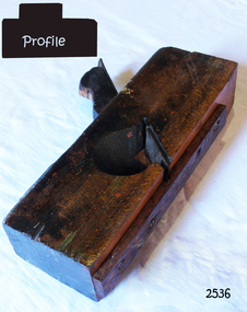 Flagstaff Hill Maritime Museum and Village
Tool - Plane, 20th century
A special version of the rebate plane, the keel and stem rabbet plane. This was a wider than the usual rebate or rabbet plane, and the blade was set askew to the side to give a slicing action. It was used for cleaning out the rabbet cut from the head of the stem, and along the keel, to take the ends and edges of the planking - its angle varied according to the ship.Rabbet plane. Has a makeshift piece of wood screwed to base to protect it. Made by Sherman Nth York. Blade size 2". A square piece of leather is tacked to top of plane. Red paint markings are on one side.flagstaff hill, warrnambool, shipwrecked-coast, flagstaff-hill, flagstaff-hill-maritime-museum, maritime-museum, shipwreck-coast, flagstaff-hill-maritime-village, rabbet plane., wood working, wood working tools, hand tool -
 Supreme Court of Victoria Library
baton, c.1826
The tipstaff is a symbol of office for the court officical responsible for keeping order in the court, also called the tipstaff. This tipstaff dates from 1826 and is marked with the reign of George IV. This tipstaff was unlikely to have been used in the Supreme Court of Victoria, and is probably an item donated to the court in the 20th century.This is the only item of this nature held by the court, the item because of its age would be quite rare. This rarity makes it of state significance, further research needs to be undertaken with regard to national and international (ie. UK) significance.Painted black wooden baton, with gold leaf inscription. Baton has been shaped to provide a hand grip with three wooden grooves, barrel/cylinder shape at the other end.Painted "Gold Crown/1826/ GR IV/ R. 11"tipstaff, tipstaves, courts, judiciary, wood, supreme court melbourne -
 Supreme Court of Victoria Library
Portrait, Justice Sir Thomas a'Beckett
... when this portrait was painted. In his hand he holds a rolled... when this portrait was painted. In his hand he holds a rolled ...The Argus reports that “In 1916 the members of the bar took the opportunity afforded by his [a’Beckett’s] 80th birthday, and the completion of 30 years on the bench to present to the judges of the Supreme Court, with his permission a portrait of himself, to be placed in line with portraits of other judges in the Supreme Court library. The portrait which depicts Sir Thomas a’Beckett in his robes, was an excellent piece of work of Mr Max Meldrum. The unveiling was made the occasion of a little demonstration at which some congratulatory speeches were made." Sir Thomas a'Beckett arrive in Melbourne as a teenager with his parents in 1851. His uncle was the former Chief Justice, his father a well known solicitor. At the Bar Sir Thomas mainly worked in the Equity jurisdiction, which he took as a specialisation with him to the bench. This is an early work of Meldrum, he won the Archibald prize for portraiture in 1939 and 1940.The portrait is of interest for whom it portrays and as the early work of a well known artist.A full length portrait in oils of Justice Sir Thomas a'Beckett. Sir Thomas is seated, his feet placed on a plush red foot stool. He is dressed in his red judicial robes with white fur trimming and black trousers and a full bottomed wing. Justice a’Beckett has a white beard and moustache, he was 80 years of age when this portrait was painted. In his hand he holds a rolled document. At his elbow, there are books upon a table. He sits in a fine carved wood and leather chair, in the background a gold frame is just visible. A line in the canvas indicates that the size of the painting was expanded. The frame is gold with a gum leaf motif.Max Meldrum 1916a beckett, max meldrum, judge -
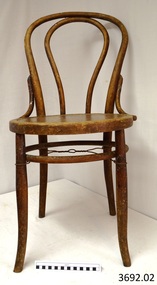 Flagstaff Hill Maritime Museum and Village
Furniture - Chair, early 29th century
The Bentwood chair has been called ‘the world’s most popular chair’. The original Bentwood chair, was designed by German-Austrian cabinet maker and Master Joiner, Michael Thonet (b.1796 - d.1871) and introduced to the market in 1859. Thonet started his business in his home town of Boppard as an independent cabinet maker in 1819. In the 1830’s he began trying to make furniture from glued (laminated) and bent wooden slats. Over the next few years his attempts to patent this process failed in Germany, Great Britain, France, and Russia. He then began using lightweight, strong wood and bending it into elegant, comfortable furniture. The Bentwood technology took Thonet years to perfect. In simple terms, the wooden rods or lengths were wet by soaking or steaming, bent into shape and then held in place until they hardened into the moulded curved shape or pattern. The wood usually chosen for the bentwood chairs was maple or beech. Thonet had revolutionised an older process by industrialising the process. The dowels of wood were cut and prepared as components of furniture, treated by the ‘bentwood’ process, then ready immediately for assembling with very little extra workmanship needed. Thonet held 2 patents for this process, the second one ended on 10th July 1869 and was non-renewable. At the Trade Fair at Koblenz of 1841 Prince Klemens Wenzel von Mettemich was very impressed with Thonet’s furniture, especially the chairs. In 1842 Thonet sold his Boppard business and emigrated to Vienna, and began working, along with his sons, on the interior decoration of the Palais Leichtenstein, for the Carl Leistler establishment. In 1849 he began his own business again, the Gebruder Thonet to include his sons (translated “Brothers Thonet”). He produced the “No. 1” Bentwood chair. He received a bronze medal for his Vienna bentwood chairs at the World Fair in London in 1851, and a silver medal in Paris in 1855. In 1856 he opened a new factory in Koritchan (Moravia), where there were extensive woods of beech trees available for his enterprise. In the next years, five more Eastern European production sites were established in Bystritz (1862), Nagy-Ugrócz (1866), Wsetin (1867), Hallenkau(1867) and Nowo-Radomsk(1880). Thonet’s 1859 No. 14 “chair of chairs” (or “Konsumstuhl Nr. 14” – coffee shop chair no. 14) was the most famous of all of Thonet’s Bentwood chairs. In 1867 he received a gold medal at the Paris World Fair. This new style of furniture making became very popular. Up until 1830 50 million of these chairs had been produced. By the 1870’s Thonet owned offices in almost 20 countries, with sales locations across Europe, in Chicago and New York. In 1889 he set Thonet set up a head office in Frankenberg, Hesse. Bentwood models designed in the mid to late 19th century featured hand-caned or laminated wood seats and were usually stamped with the country of origin. The Bentwood elements were the backrest, seat rim and legs. Typically the seat was covered with ‘bucket’ leather. After the Patent ran out in 1869, companies such as Jacob & Josef Kohn began the production of bentwood furniture.The popularity of the Bentwood chair that was introduced by Michael Thonet in the 1850s is due to its versatility and timeless quality. Its style, whether varnished or painted, suits any room in the house. The lightweight chairs are also popular for café and restaurant seating, as well as for public gatherings. They can be easily moved around and grouped in a variety of ways to suit any occasion.Chair, bentwood, pair of two. Backrest has full length inverted U inside frame. Support rail and wire reinforcing between legs. 3692.01 seat has floral pattern pressed into wood 3692.02 seat is plain (replacement seat). Made by Harnison & Co.3692.01 chair's marks; Label ""HARNISON & CO./ NEUSOL / BUDAPEST" and "WIENER NOBEL" and "(symbol) N inside circle, under Crown" flagstaff hill, warrnambool, shipwrecked coast, flagstaff hill maritime museum, maritime museum, shipwreck coast, flagstaff hill maritime village, great ocean road, domestic furniture, dining furniture, bentwood chair, harnison & co., neusol, budapest, wiener nobel -
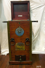
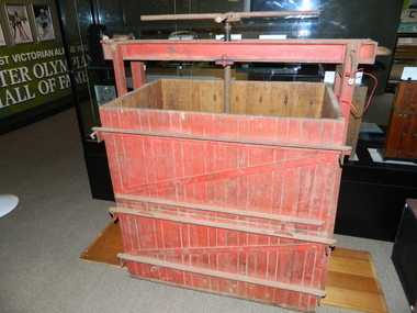
 Bendigo Military Museum
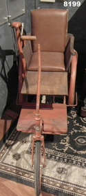
Accessory - WHEEL CHAIR MOBILITY AID, Webster Brothers, C.Post WW1
This mobility aid was housed under the old stage area of the Soldiers Memorial Institute building in Pall Mall Bendigo. When the renovations to the building began in late 2016 the Aid was removed and restored by the Bendigo District RSL Men in Sheds program and is now on display in the same building now called Bendigo Military Museum. The Soldiers Memorial was the HQ of the Bendigo RSL Sub Branch. It is not known the origin of the Aid but it was most likely used by disabled Bendigo RSL members post WW1.Three wheeled Mobility Aid. Front wheel is 41cm dia pneumatic, 32mm wide, rear wheel 68cm dia, width 52mm wide. The right wheel axle has a sprocket & chain assembly, the left is free wheeling, both have mud guards. Frame is tubular steel painted reddish colour, the seat and back rest are brown leather, seat sides are timber, there are two timber platforms in front, the top one is adjustable the bottom one is fixed. The chair is steered via a long metal handle fixed to the wheel frame. The right hand side has the sprocket and chain assembly and motion is controlled by turning the handle in a circular motion, only one speed.on the front wheel stem is a transfer. “Webster Brothers Cycle Manufacturers Mitchell Street Bendigo”mobility, aid, wheel chair, brsl, smirsl -
 Warrnambool and District Historical Society Inc.
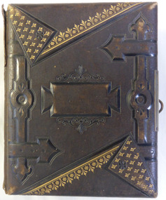
Album - Family photo album, Photographs
This album contains a collection of family photos, greeting cards and hand drawn floral emblems. Among the photographs are two which have details on them: a young girl named Margaret Clarke aged 8 1870 and another of Charles Alexander Clarke. The photographers are from many places including Britain, Melbourne, Portland and a number by Daniel Clarke of Warrnambool. Daniel Clarke was one of Warrnambool’s more important photographers, operating a business for thirty years in the town. He also worked as an artist and taught art in local schools. He painted a number of versions of Tower Hill. He died in 1918 at the age of 91.This album shows a collection of photographs and cards which were important to families in the later part of the 19th century. It has artistic and historical significance, with the photographs in particular depicting many different styles of clothing and household details of the time. Brown leather with a figured pattern and gold detail. Bent metal clasp Back cover in cross-hatched pattern. Spine has 5 horizontal lines. Edges of pages are edged in gold. Pale grey water wave patterned paper inside front and back covers. Pages inside are varied with some having coloured floral embellishments while others have pockets to hold from 1 to 4 photographs or card. One photograph of young boy has Charles Alexander Clarke written on bottom in black pen. A card with illustration of honeysuckle on front, has With Love to Mrs. Smith from Isabel,warrnambool, history of warrnambool, margaret clarke aged 8 1870, charles alexander clarke 1870, daniel clarke photographer -
 Warrnambool and District Historical Society Inc.
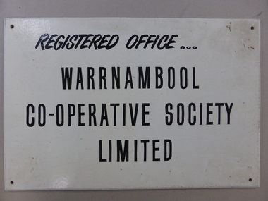
Plaque, Warrnambool Co-operative Society Limited, 6 August 1976
Rectangular white painted sign board with black text and a hole in each corner for attaching the sign to the wall. The sign has dirt on the surface and into the top right-hand corner. The signwriter's inscription in brown texta is on the back. Front: REGISTERED OFFICE .../WARRNAMBOOL/CO-OPERATIVE SOCIETY/LIMITED Back: GRANT PHILLIPS/Signs/WARRNAMBOOL/6-8-1976signwriters, grant phillips, business signs, warrnambool co-operative society limited -
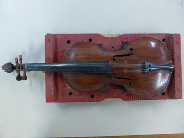 Warrnambool and District Historical Society Inc.
Instrument - Musical Instrument, Violin and stand, Early 20th Century
This violin was made by Mr Edward Richter who lived in Warrnambool for 78 of his 85 years. he was born 10/03/1853 and was an expert model maker making models of ships. The Warrnambool Museum in 1937 held a model of the Cutty Sark which he had made from timber from the wreck of the Enterprise which was wrecked on Warrnambool beach. Violins were another of of his hobbies.This violin has a connection to Warrnambool through the maker who was a long time resident of the town. It belongs to an era when many people were interested in and turned their hand to making objects such as this.The body of the violin is stained brown in colour with black neck and bridge. The four strings are nylon. The pegs and scroll are timber of a finer grain than the front and back.The tailpiece and end button are black material. The bridge is missing. The stand is rectangular with violin shape cutout, painted in red with a ply backing. Small leather strap on one end. Six large and two small drilled holes around front section.Richter written in large letters on back of standwarrnambool, edward richter, handmade violin, richter warrnambool -
 Warrnambool and District Historical Society Inc.
Clock, Wall Clock, Late 19th century?
This clock has no known provenance but has been in the Warrnambool and District Historical Society collection for many years. This clock is a good example of a 19th century (or perhaps early 20th century?) wall clock and is an attractive display item. This is a wooden- frame clock for hanging on a wall. The face is tin painted cream with some paint missing. The numbers on the face are Roman numerals and the hands have Maltese crosses at the ends and are painted. The face is inlaid with 6 small circular dots of mother-of-pearl and there are seven similar inlaid circles on the wooden base. The glass covering the dial is hinged and brass-edged. The wooden base has fretwork and scroll sections and carved decorative edges and a rounded bottom. One side piece of the decoration is missing. The fretwork piece opens to show a brass pendulum. At the back of the clock are two pegs and a metal clip for hanging the clock. ‘Phillip Hunter & Co. London’ history of warrnambool, wall clock -
 Warrnambool and District Historical Society Inc.
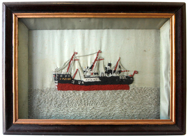
Textile - Casino embroidery, S.S. Casino
The SS Casino was a coastal trader of 450 tons gross, 160.4 feet in length, built at Dundee for the Newcastle and Hunter Steam Navigation Company. It had saloon accommodation for 35 people, fore-cabin 25 and carried 300 tons (425 tonnes) of cargo.The Casino called at Warrnambool on 30th May 1882 while on her delivery voyage and narrowly escaped being dragged ashore by gale force winds. While the ship was in Warrnambool the directors of the Belfast and Koroit Steam Navigation Company bought the ship. It was used as a coastal steamer solely on the west coast of Victoria run from 1882. On the morning of 10th July 1932 an attempt was made to berth the ship at Apollo Bay in heavy seas. Captain Middleton decided to take the ship out into the bay and wait until the seas abated, not realising that the anchor used to steady the ship as she was being manoeuvred had pierced her hull. The ship was put about and headed to the beach, but sank. The captain and four crew members were swept off the deck, and though one crew member was rescued, four drowned. The beaded picture was made by Mary Wickham, the grandmother of the donor. This item has significance linking a piece of handcraft and a local ship from the late 19th century.It has significant artistic value. Hand worked embroidery of black, white, maroon, gold & clear glass beads on a background of white polished cotton. The embroidery is in a black painted wooden frame. It is backed by a sheet of "War Cry" 26th April 1896. "Casino" in gold beading on bow of ship.the casino ship, warrnambool casino, warrnambool shipwrecks -
 Warrnambool and District Historical Society Inc.
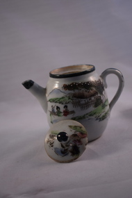
Artefact, Teapot, Circa 1900
We have little knowledge on this little teapot but is an item of interest and could even be part of a child’s tea set, based on its size. The hand painting on the pot is quite a typical depiction of Japanese scenes from the 19th century. We could find no provenance belonging to this item but it is an interesting and pleasing item suitable for display.Small white china teapot with lid and Japanese scene on both sides with trees and mountains in the background and village houses in the foreground. It is painted in greens, browns and blue and the painting is outlined in a slightly raised style. The trees in the background have raised white dots of paint. The front scene has two ladies and another person in a boat. The lid also has a similar scene. The lid, handle and rim of the spout are all highlighted in dark green.warrnambool, warrnambool history, teapot, asian teapot -
 Kiewa Valley Historical Society
Scales Weighing Pocket, circa early 1900s
Historically this item would have been used by gold miners, rabbit shooters, mobile "Rag and Bone" traders and other mobile(in caravans and/or horse drawn cart) traders of various small goods and haberdashery. Although marked as not to be used as trade, the isolation and sometimes difficult terrain rules out using larger and more delicate scales. In the early 1900s rough roads and severe weather conditions forced traders to be more flexible in trading with weights and measures. The "close enough is good enough" doctrine was the Australian outback rule of thumb.The significance of this item in the Kiewa Valley during this period demonstrates the slower acceptance of accurate trading measure using the country side principle "my hand shake is my bond". In the Kiewa Valley small quantity commercial undertakings e.g. gold mining, fur pelts and rabbit meat trade did not require bulk weight type scales. Commerce in rural production e.g. fruit and vegetables involved more farmers and their staff in a barter and/or "in kind" payments. This was more so in the depression years 1929 to late 1930s. Self sufficiency was to a large extent more attainable in this region than in the city/ large country town environment. The Australian "fair go" ethical approach to life and commerce was very much ingrained in those living in country regions, like Kiewa Valley as is demonstrated by the not so accurate hand balance, spring loaded scales.This brass "faced" portable Pocket Balance ( Fish Scales) has front plate made from thin pressed brass. The mild steel spring mechanism enclosed by black painted medium gauge steel cover( three quarters cylindrical). Front scale face and rear spring casing fastened by three rivets. Spring loaded marker blade is located in the centre of the front plate. A steel " finger holder" ring is attached at the top of the scale unit from one of two pre drilled holes. The top is for holding the scale upright and the bottom for a hook to dangle the item to be weighed from the bottom. See item KVHS 0223 for similar scales"THE BILLY BALANCE" and at the bottom "MADE IN GERMANY"antique pocket balance, scales, mobile weights, vintage appliances -
 Kiewa Valley Historical Society
Tobacco Hand Press
Tobacco farming began circa 1960 in the Kiewa Valley and consequently became one of it major industries. Many of the italian families were involved in tobacco farming.Historical: This equipment was used on one of the first tobacco farms in the Kiewa Valley at Mongans Bridge. Provenance: This tobacco farmer came from Italy and was sponsored to visit a tobacco farmer in Myrtleford to learn how to grow tobacco so that he could transfer those skills to his own farm in the Kiewa Valley.Wooden, panelled red (painted on outside) rectangular box on side are iron bars with steel reinforcements around the box, near the top and bottom on 4 sides and across the middle on the 2 ends and front (not back). Diagonal steel between bottom and middle iron on the front. Ends: 2 iron bars from the ground curved up to top holding an iron rectangular beam that goes from end to end. Midway of beam is a vertical long screw at the top of which is a cross formation of 4 iron rods forming a handle for turning. Inside, the screw is attached to an iron frame which is attached to a wooden panelled platform enabling it to be raised or lowered as required.tobacco. mongans bridge. kiewa valley. hand press. parmesan. rossaro. lorenzi brothers. -
 Kiewa Valley Historical Society
Hookey Board
This Hookey board was made of metal unlike many made of wood. The Mt Beauty Rural Fire Brigade was established by the State Electricity Commission of Victoria as an 'industry' brigade. When Mt Beauty was handed over to the Shire in 1961, the Fire Brigade became a member of the Country Fire Authority (C.F.A.). Today it is an urban fire brigade.This Hookey board was used by the members of the Mt Beauty Rural Fire Brigade from 1948 when the State Electricity Commission established the brigade. Grey metal round board with edge. 13 metal hooks spaced on front with embossed numbers 1 - 13 under each. A small circular engraved brass plaque under No. 13 and between No.s 9 & 10. Metal chain attached at top (for hanging). Embossed "Hookey"between No.s 1 and 13. Embossed numbers 1 - 13. Plaque "C A V .. Sales" on top. "Melbourne" on Bottom. "Quality Products" in middle. Cream paint splash right of centre and slightly on plaque.hookey; mt beauty; rural fire brigade; entertainment; -
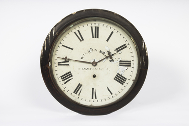 Warrnambool and District Historical Society Inc.
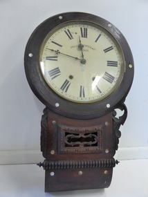
Functional object - Railway Clock, Wilson Brothers, Clock Makers, Warrnambool, 1890s
This clock is believed to have come from the Warrnambool Railway Station. The Railway commenced in 1890 and the station was opened in 1897. The clock was made by Wilson Brothers, a prominent manufacturing watch and clock- making business in Timor Street, Warrnambool in the second half of the 19th Century.This item is of considerable significance as an early Railway Clock in Warrnambool. Railway Clocks were important in the 19th century as prominent time pieces for the general community to use to establish the time of day.This is a clock with a circular face behind glass enclosed in a metal frame with wood surrounds The wooden frame is attached to a wooden rectangular box with a curved bottom. The box has a metal clip for attachment to a wall or a board. The metal face is white with black painted Roman numerals, which are damaged, and black printing. Minute markers are indicated. The hands are metal. All the metal is rusted.Wilson Bros Warrnamboolwarrnambool railway station, wilson brothers warrnambool