Showing 924 items matching "land subdivision"
-
 Ringwood and District Historical Society
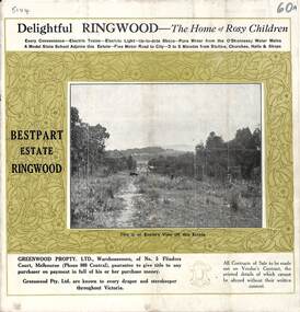
Pamphlet, Land Sale Brochure, Bestpart Estate, Ringwood - circa 1925
Twelve page land sale brochure including photographs, subdivision features and local facilities. Additional flyer with conditions of sale and prices for estate blocks.Subdivision plan includes Bedford Road, Greenwood Avenue, Caroline Street, Wilanna Street, Henry Street, Haig Street -
 Ringwood and District Historical Society
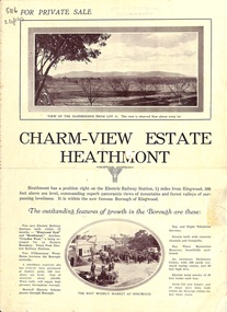
Flyer, Land Sale Brochure, Charm-View Estate, Heathmont, Vic. - c1926
Double sided folded page advertisement highlighting local facilities, services and layout of blocks for sale in Charm-View Estate.Subdivision includes Heathmont Road, Orchid Street, Bennett Avenue, Dickasons Road and Canterbury Road. (Agents) T. Burkitt & Co., Phone Ringwood 157, Overton & Co., 390 Chapel Street South Yarra, Phone Windsor 542. Solicitor A.V. Wischer, 443 Chancery Lane, Melbourne. -
 Ringwood and District Historical Society
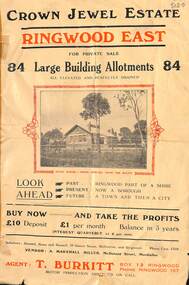
Flyer, Subdivisional Land Sale Brochure, Crown Jewel Estate, Ringwood East, Vic. - c.1925
In May 1884, George Smart of Bulleen Road Kew, brickmaker, bought the 23 acres one rood and twenty nine and three tenths perches, or 9.4834 hctares from Arthur Bailey Clements of Ringwood for the sum of 600 pound sterling. (Extract from The Story of the Crown Jewel Estate in Ringwood East pdf)Double sided folded page with black and red print on both sides advertising auction sale of residential and business sites and highlighting local facilities, services and layout of the estate.Subdivision includes Mount Dandenong Road, Valda Avenue, Evon Avenue, Mirabel Avenue, and Velma Grove. (Agent) T. Burkitt, Box 12 Ringwood, Phone Ringwood 157. Vendor: A. Marshall Miller, McDonald Street, Mordialloc. Solicitors: Russell, Bona and Russell, 19 Queen Street Melbourne, and Ringwood - Phone Cent. 4308. -
 Ringwood and District Historical Society
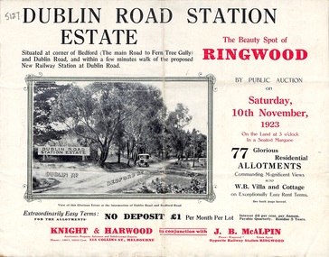
Pamphlet, Land Sale Brochure, Dublin Road Station Estate - 1923
"Extracts from Recent Daily Newspaper - Ringwood Train Service - STATION WANTED AT RINGWOOD EAST. A deputation from the Ringwood East Railway League and Progress Association waited on the chairman of the Railway Commissioners yesterday afternoon and asked that a railway station be erected at Dublin-road, a mile and a quarter from Ringwood. The deputation urged that there were 81 passengers who, if the station were provided, would make daily use of it, and that as the Commissioners had purchased a site for a station at Dublin-road it was evident they had at one time considered it the most suitable site. The Chairman of Commissioners stated that the estimated cost of the station was £3700. Land owners in the locality should pay a proportion of the cost. Members of the deputation replied that there would be no difficulty in raising the money."Multi-fold brochure advertising public auction of residential allotments on Saturday, 10th November, 1923. Brochure includes subdivision features, local facilities and photographic images of the area and details of proposed new railway station at Dublin Road.Subdivision plan includes Dublin Road, Alexandra Road, Vonadawn Avenue, Green Street, Howard Avenue, Wood Street, and Bedford Road (Main Ferntree Gully Road). Auctioneer - Knight & Harwood, 315 Collins Street, Melbourne, Phones Central 10615, 10616. Agent - J.B. McAlpin, Opposite Railway Station, Ringwood, Phone Ringwood 7. -
 Ringwood and District Historical Society
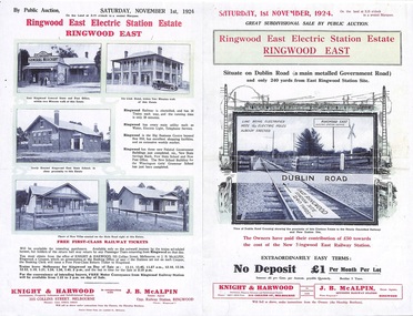
Flyer, Land Sale Auction Brochure, Electric Station Estate, Ringwood East, Vic. - 1924
Folded double-sided advertisement for Ringwood East Electric Station Estate subdivisional sale of retail and residential allotments by public auction on Saturday, 1 November, 1924, with local photographs, terms of sale, and summary of subdivision features and local facilities. Subdivision includes Railway Parade (later Patterson Street, Rosedale Crescent, Federal Road, Howship Avenue (later Howship Court and French Street), and Dublin Road. (Agents) Knight & Harwood, 315 Collins Street, Melbourne, Phone Central 10615, 10616, in conjunction with J.B. McAlpin, Opposite Railway Station, Ringwood, Phone Ringwood 7. -
 Ringwood and District Historical Society
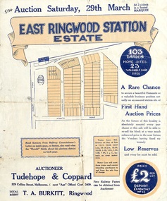
Flyer, Land Sale Auction Brochure, East Ringwood Station Estate - 1924
Bi-folded double sided sheet with yellow and blue print advertising auction of retail and residential allotments on Saturday, 29 March (1924), including details of subdivision features and local facilities. Subdivision includes Station Street, Wenwood Street, Lois Street, Victoria Street. Auctioneer - Tudehope & Coppard, 229 Collins Street, Melbourne, Tel. Central 2409, in conjunction with local agent, T.A. Burkeitt, Ringwood, Tel. Ringwood 157. -
 Ringwood and District Historical Society
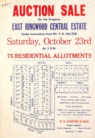
Flyer, Land Auction Sale Advertisement, East Ringwood Central Estate - 1948
See Victorian Collections reference 5125 for subsequent Central Estate East Ringwood subdivision flyer.Single sided land auction sale advertisement for residential allotments.Auction Sale on the property under instructions from Mr. F.A. Salter. Subdivision includes Dublin Road, Knaith Road, Talofa Avenue, Russet Road, and Shasta Avenue. Agent - C.E. Carter & Son, Main Street, Ringwood. WU 6024. -
 Ringwood and District Historical Society
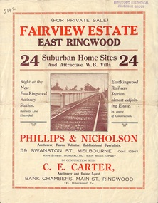
Flyer, Land Sale Brochure, Fairview Estate, East Ringwood, Vic. - circa 1925
Bi-folded single sheet advertisement for private sale of residential allotments, including subdivision features and local facilitiesSudivision includes Eastfield Road, Margaret Street and Patterson Street. Local Agent - C.E. Carter, Bank Chambers, Main St., Ringwood. Tel. Ringwood 24. -
 Ringwood and District Historical Society
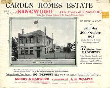
Flyer, Subdivisional Land Auction Sale Brochure, Garden Homes Estate, Ringwood, Vic. - 1923
Double sided multi-folded page advertising auction sale of residential allotments highlighting local facilities, services and layout of the estate. Includes panoramic view of Ringwood and other local photographic images.Subdivision includes Mullum Mullum Road, The Centreway, Wattle Crescent and Reserve Crescent. Agents - Knight & Harwood, 315 Collins Street, Melbourne, Phone 10615, 10616 Central, in conjunction with J.B. McAlpin, Opposite Railway Station, Ringwood. Phone Ringwood 7. -
 Ringwood and District Historical Society
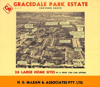
Flyer, Land Sale Brochure, Gracedale Park Estate, Croydon South, Vic. circa 1968
Although the brochure advertises Gracedale Park Estate as Croydon South, the home sites and streets are in the 3135 postcode area, i.e. Ringwood East/Heathmont.Bi-folded orange coloured sheet with black print advertising sale of residential allotments, including subdivision features and local facilities.Sudivision includes Ringwood East streets - Gracedale Avenue and Raymond Court. Agent - H.G. McLean & Associates Pty. Ltd., 166 Canterbury Road, Heathmont. Telephone 870 3422, A/Hours 870 5879, 729 2809. -
 Ringwood and District Historical Society
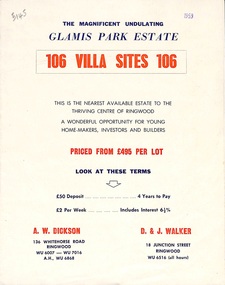
Flyer, Land Sale Brochure, Glamis Park Estate (Wantirna, Vic.) - 1959
Street name Carnarvon Avenue on the subdivision plan became Selkirk Avenue at some stage during or subsequent to development of the Estate.Bi-folded advertisement for sale of residential allotments, including summary of subdivision features and local facilities.Subdivision includes Wantirna streets - Wantirna Road, Carnarvon Avenue, Inchcape Avenue, St Thomas Avenue, St Davids Drive, Dudley Avenue, Angus Avenue. Agents - A.W. Dickson, 136 Whitehorse Road, Ringwood, Telephone WU 6007, WU 7016, A.H. WU 6868. D. & J. Walker, 18 Junction Street, Ringwood, Telephone WU 6516 (all hours). -
 Ringwood and District Historical Society
Article - Newspaper Clipping, Land Sale Advertisements, Golden Hill Estate, Ringwood - 1965, 1966, and Plan of Survey of Lot 8, Mullum Mullum Road Ringwood, 1970
Newspaper clippings from Melbourne Sun newspaper (11th December 1965 and 15th January 1966) advertising sale of land - Golden Hill Estate, Ringwood, with summary of features and aerial photograph including artistic representation of street layout. Subdivision includes Mullum Mullum Road, Sonia Street, Jill Court, Linda Drive, Eve Court, Alma Court, and Jacynthe Court. Attachments include reference to Lot 46 as site of original Peter Vergers' orchard residence and subsequent 1970 surveyor's Plan of Survey of Lot 8 Mullum Mullum Road Ringwood, LP 67513, Cert of Title 8581/429.Agent - Aaron, King & Co., Suite 2, 33 Queens Road, Melbourne. (Phone) 26-2443, A.H. 850-2195. Plan of Survey signed on 25.7.1970 by Roger M. Gamble, Land Surveyor, 28 Summit Crescent, Ringwood 3134. -
 Ringwood and District Historical Society
Flyer, Subdivisional Land Auction Sale Brochure, Grand Central Estate, Ringwood, Vic. - 1925
Douglas Street shown in the estate plan did not eventuate, but was developed as a public reserve. Refer also to Reg. No. 5149 for 1924 auction sale of land also titled Grand View Estate situated further north in Ringwood.Double sided multi-folded page advertising public auction sale on Saturday, 31st October, 1925, of residential allotments highlighting local facilities, services and layout of the estate. Includes panoramic view of Ringwood and other local photographic images.Subdivision includes Great Ryrie Street, Heathmont Road, Douglas Street, Garden Street, and Bellevue Avenue. Agents - Knight & Harwood, 315 Collins Street, Melbourne, Phone 10615, 10616 Central, in conjunction with J.B. McAlpin, Opposite Railway Station, Ringwood. Phone Ringwood 7. -
 Ringwood and District Historical Society
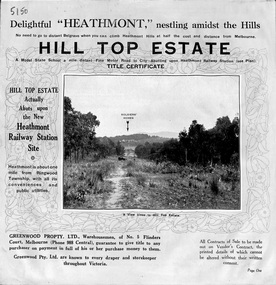
Pamphlet, Atlas Press Pty. Ltd., Melbourne, Land Sale Brochure, Hill Top Estate, Heathmont, Vic. - circa 1925
Twelve page land sale brochure promoting Heathmont and Ringwood area including photographs, subdivision features and local facilities. Subdivision plan includes Heathmont Road, Balfour Avenue, Edith Street, Edna Street, and Great Ryrie Street. -
 Ringwood and District Historical Society
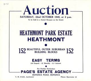
Flyer, Land Auction Sale Brochure, Heathmont Park Estate, Heathmont, Vic. - 1949
Double sided multi-fold advertisement for auction sale of residential allotments, including summary of subdivision features and local facilities. Auction on Saturday, 22nd October, 1949, at 2 p.m.Subdivision includes Great Ryrie Street, Erica Crescent, Neil Street, Frances Street, Viviani Crescent, and Canterbury Road. Agent - Page's Estate Agency, Boronia Road, Boronia. Phone Bayswater 42. -
 Ringwood and District Historical Society
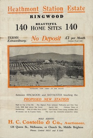
Flyer, Land Sale Brochure, Heathmont Station Estate, Ringwood, Vic. - circa 1925
Extract of "Herald" 2/2/22: The intention of the Railway Commissioners is to electrify the line to the Gully as soon as convenient, and with greater frequency of service many persons settled, and settling, in the district will be benefited. There is a scheme which may be launched that will allow for an express service of fast trains to the Gully. The commissioners are alive to the necessity for assisting to settle the picturesque districts between Box Hill and Gembrook.Bi-fold advertisement for sale of retail and residential sites, including panoramic and other photographs, map, and summary of subdivision features and local facilities. Subdivision includes Canterbury Road, Station Street (later Wainui Avenue), Lisgoold Street, Viviani Crescent, and Balfour Avenue. Agent - H.C. Costello & Co., Auctioneer, 128 Queen Street, Melbourne, or Church Street, Middle Brighton. Phones: Central 10517 and X1205. -
 Ringwood and District Historical Society
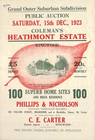
Flyer, Land Sale Brochure, Coleman's Heathmont Estate, Ringwood, Vic. - 1923
Bi-fold advertisement for auction sale of residential sites, including photographs, map, and summary of subdivision features and local facilities. Auction date Saturday 15th December, 1923. Subsequent auction date Saturday 19th January, 1924, following previous sale stopped on account of rain. Initial newspaper advertisement (publication unknown) dated 16/11/23.Subdivision includes Bedford Road, Canterbury Road, Alvena Crescent, Leonard Street (later Royal Avenue), and Coleman Street. Agent - Phillips & Nicholson, 281 Collins Street Melbourne, (Phone) Central 10907, in conjunction with C.E. Carter, Main Street, Ringwood. Tel. Ringwood 24. -
 Ringwood and District Historical Society
Flyer, Land Sale Brochure, Heathmont Estate, Vic. - circa 1960
Advertisement for sale of residential lots - Heathmont Estate, opposite Heathmont Railway Station, with map and locality plan.Subdivision includes Canterbury Road, Royal Avenue, Coleman Street, Stoda Street, Herman Street, and Campbell Street. Agent - A.W. Dickson, opposite Station, Ringwood. Phone WU6007. -
 Ringwood and District Historical Society
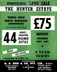
Flyer, Land Sale Brochure, The Hunter Estate, North Ringwood, Vic. - circa 1960
Bi-fold land sale advertisement for The Hunter Estate, North Ringwood, including terms of sale, area map, layout of the estate, and summary of local facilities and services, with separate attachment listing lot number prices.Subdivision includes Wonga Road, Hunter Avenue (later Graeme Avenue), Panfield Avenue, Hendra Grove, and Mullum Mullum Road. Agent - N.R. Reid & Co. Pty. Ltd., Station Entrance, Ringwood. (Phone) WU 6661. -
 Ringwood and District Historical Society
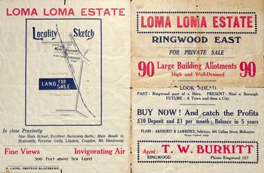
Flyer, Land Sale Brochure, Loma Loma Estate, Ringwood East, Vic. - circa 1924
Flyer includes extract from "The Sun" 30/10/1924. "Ringwood has been created a Borough with capital value of £680,000. In 1908 there were 173 houses, 8 shops and 720 people. In 1918 the respective figures were 520, 45 and 2,080. For twelve months ended June, 1924, £51,000 worth of Home Sites were sold and £26,000 worth of new buildings were erected. Outward (train) passenger journeys have increased from 94,000 in 1919 to 182,000 in 1923. Train services have been almost doubled and time to Melbourne reduced from 60 to 37 minutes."Bi-fold double-sided land sale advertisement for Loma Loma Estate, Ringwood East, including area map, layout of the estate, and summary of local facilities and services.Subdivision includes Loma Street, Highton Street, Morinda Street, and Station Street (later Railway Avenue) Ringwood East. Agent: T.W. Burkitt, Ringwood, Phone Ringwood 157. -
 Ringwood and District Historical Society
Flyer, Executor's Auction Subdivision Advertisement, Lilydale Road and Oban Road, Ringwood East, Vic. - 1937
Single page advertisement for Executor's Auction of land in Ringwood East on Saturday, May 29, 1937 with locality map showing 26 building sites for auction highlighted in brown, and brief summary of local services available. Subdivision includes Old Lilydale Road, Joseph Street, Dynes Street, Albert Street (later Wyrunga Street), Carcoola Road, and Mount Dandeong Road. (Carcoola Road incorrectly shown as Oban Road on the subdivision plan). Auctioneer - C.E. Carter, (Phone Ringwood 24. -
 Ringwood and District Historical Society
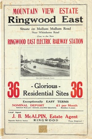
Flyer, Land Sale Brochure, Mountain View Estate, Ringwood East, Vic. - 1923
Bi-fold advertisement for sale of residential allotments, including photographs, map, and summary of subdivision features and local facilities. Undated handwritten notation reads "streets don't exist today".Subdivision layout includes Mullum Mullum Road, Rangeview Avenue, Press Avenue, and Mountview Avenue. Local Agent - J.B. McAlpin, Opposite Railway Station, Ringwood, Phone Ringwood 7. Vendor - T.J. Press, Builder, "Monterey", Second Avenue, Kew, Telephone Haw. 3428. -
 Ringwood and District Historical Society
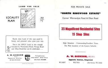
Flyer, Land Sale Brochure, North Ringwood Estate, Ringwood, Vic. - 1958
Double-sided land sale advertisement for sale of 35 residential and 15 shop sites on the corner of Warrandyte Road and Oban Road, Ringwood North, Vic., including locality plan and features of the estate.Subdivision includes Oban Road, Warrandyte Road, and Dickson Crescent. Agent: A.W. Dickson, Opposite Station, Ringwood. (Phone) WU6007, WU7016, after hours WU6868. -
 Ringwood and District Historical Society
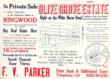
Flyer, Land Sale Advertisement, Olive Grove Estate, Ringwood, Vic. - 1926
Further development of 9 shop sites took place along Whitehorse Road (later street numbers 58 to 64 Whitehorse Road) between New Street and Olive Grove around 1950 - See Victorian Collections reference 5227.Single sided page with red and blue print advertising Olive Grove Estate business and residential allotments, including subdivision plan and summary of local services.Subdivision includes Whitehorse Road, New Street, and Olive Grove. Agent - F.V. Parker, Telephone 131, Ringwood. -
 Ringwood and District Historical Society
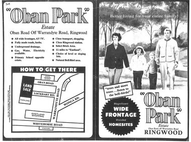
Flyer, Land Sale Advertisement, Oban Park Estate, Ringwood, Vic. - 1969
One double-sided and two single-sided pages advertising Oban Park Estate land sale, including terms of sale, locality map, subdivision features and summary of local services.Subdivision includes Oban Road, Terrigal Close, Dorelaw Drive (later Melview Drive), Naroo Court, Barook Court, and Lockhart Road. Agents in Conjunction: E. Wachman, Melbourne, Hutchinson Real Estate, Ashwood, and A.W. Dickson, 136 Whitehorse Road, Ringwood (Phone) 870-6007 A.H. 882967. Separate newspaper advertisement (digital only) shows agents - Hutchison Real Estate (Telephone 277-2326) and Michelson Gelfand Pty Ltd (Telephone 53-8151). -
 Ringwood and District Historical Society
Document, Land Title Certificate for Henrietta Greenwood of Ringwood, Vic. - 31st January, 1931. (4 pages)
... , Ringwood, Victoria, including Transfers and map of subdivision Land ...Certificate of Title - Henrietta Greenwood, Ringwood, Victoria, including Transfers and map of subdivisionIncludes transfers as part to Ernest Allan Devenish, 27th October, 1938 Lillian Alice Clegg, 10th July, 1936 Francis Leslie Little and Rose Little, 12 November, 1940 Ralph Wigley, 25 November, 1937 Alan Geoffrey Clegg, 25 November, 1937 Phillip McKinley, 8 May, 1941 John Andrew Pearson, 11 May, 1938 Paul Clegg, 8 May, 1941 The Mayor, Councillors and Burgsses of the Borough of Ringwood, 18 June, 1941 Ruby Grace Holloway, 15 October, 1941 William Herbert Holloway, 28 June, 1949 -
 Warrnambool and District Historical Society Inc.
Subdivision plan, Part of Preston Estate Parish of Wappan
This map possibly relates to land of John Bostock at Preston, Delatite. Part of a collection of papers relating to the Bostock family one of the earliest pioneering families in Warrnambool.Cream coloured map printed in black with sections coloured in pink. Plan of subdivision of part of crown allotments 15 and 17 and part of Preston pre- emptive right, Parish of Wappan, County of Delatite.warrnambool,bostock,augustus bostock map, delatite map,district of wappan map, -
 Warrnambool and District Historical Society Inc.
Document, Wollaston sale, 1919
This is a poster advertising the sale of part of the Wollaston Estate in Warrnambool in 1919. The sections for sale were Allotments 1, 18 and 19 which included the Wollaston Homestead. The original Wollaston property of 679 acres was selected by Thomas Manifold in the late 1840s. This land, on the northern side of the Merri River, near the Woodford Road was three kilometres from the Warrnambool town. The first farmer we know who leased the property was William Simpson. Walter Manifold inherited the property and he took it over in 1884. The swing bridge he built in 1890 still stands today. In 1919 the Closer Settlement Board of Victoria acquired Wollaston and 17 lots were sold to returned soldiers for farming purposes. By 1930 there were only five soldier settlers remaining. In 2009 further subdivision took place with lots sold for residential purposes. The homestead allotments were sold separately in 1919 with various owners of the homestead itself recorded since that time. This poster is of interest as it shows the areas of the Wollaston Estate which were sold in 1919. The history of this estate is well-documented and of importance in the history of Warrnambool. This is a sheet of paper with red and black printing and a map of the Wollaston Estate which is photo-lithographed. The sheet has been folded three times. It has some small tears at the top of the page. wollaston, history of warrnambool, walter manifold -
 Warrnambool and District Historical Society Inc.
Map - Maps, Soldiers Settlement WW2, Circa 1950
The soldiers' settlement scheme operated after the first and second world wars in an effort to more closely settle the land and also give opportunities to returned soldiers. Crown land and other larger estates were acquired for the purpose. Most of these maps relate to the area north of Warrnambool where many of the subdivisions were parts of larger estates.These maps pertaining to the Soldiers' Settlement program, relate to an interesting part of Australian and local history. As such they have historic and social interest and significance.A collection of 25 paper maps which relate to to the soldiers settlement post World War 2. Some have details of the people allocated the land and some smaller maps have the printed details of the applicants requirements.Text is black on white paper which in some cases is quite aged. The maps are as follows: .1 Narrapumelap Estate ( Ripon & Hampden) .2 Narrapumelap Estate Part 2 (Villers & Ripon) .3 Narrapumelap Estate Part 3 ( Villiers & Ripon) .4 Burrumbeet Estate ( Ripon) .5 ' Berrambool' Estate 9 Hampden & Villiers) .6 ' Hopkins Hill' Estate Villiers 4011 acres .7 Caramut North No 2 Estate ( Villiers ) .8 ' Morpor' Estate ( Villiers) 4172 acres .9 ' Morgiana' Estate ( Normandy) 3453 acres .10 ' Chatsworth House' ( Villiers) 9341 Acres .11 ' East Elwood' Estate Villiers 2407 acres .12 Grey's Estate ( Mornington) 1151acres .13 ' Rowes Estate' ( Buln Buln Gippsland 733 acres .14 'Tarrone' Estate No 2 Part map .15 'Chaldon Meade' Estate (Bourke) Bulla 517 acres .16 ' Terranallum South' Estate Hampden 3757 acres .17 ' Brung Brungle' Estate Dundas 695 .18 ' Armidale ' Estate ( Dundas)2108 acres .19 ' Moyne Falls' Estate ( Villiers) 627 acres .20' Yulong' Estate 9 Lowan 6321 acres .21 Murray Valley Irrigation District 9 Moira)113 acres .22 Murray Valley Irrigation District 103 acres .23 ' Mount Fyans' Estate ( Hampden) .24 ' Barwidgee ' Estate ( Villiers) 4277 acres .25 'Pine Hills' Estate 2nd portion ( Lowan) 6190 acres narrapumelap, berrambool, hopkins hill, caramut north, morpor, chatsworth house, east elwood, terrinallum, moyne falls, tarrone, caramut soldiers settlers, burrumbeet, morgiana, grey's estate mornington, chaldon meade, brung brungle -
 Eltham District Historical Society Inc
Film - Video (DVD), Nillumbik Shire Council, Edendale Farm Community Environment Centre: History, c.2009
... . The Edendale property was originally part of an extensive land purchase.... The Edendale property was originally part of an extensive land purchase ...EDENDALE FARM Edendale Farm is Nillumbik Shire Council's environment centre situated in Gastons Road, Eltham between the railway and the Diamond Creek. The homestead on the property was built in 1896 and is of historical significance, being the subject of a Heritage Overlay under the Nillumbik Planning Scheme. The Edendale property was originally part of an extensive land purchase in 1852 from the Crown by pioneer Eltham farmer Henry Stooke. He initially purchased 51 acres and later expanded his holdings by purchasing another three adjacent Crown allotments extending northerly from Josiah Holloway's Little Eltham subdivision. Despite clearing the land, Stooke did not build on this property, choosing to live on his property "Rosehill" at Lower Plenty. In 1896 Thomas Cool, Club Manager of the Victoria Coffee Palace in Melbourne purchased 7 acres of the original Stooke land and built the house now known as Edendale. Cool did not farm the land, instead using it as a gentleman’s residence, retiring to Eltham at weekends. In 1918 he purchased an additional 7 acres but in 1919 he sold the property. Later owners included J.W. Cox, the Gaston family and D. Mummery. In the 1980s the Eltham Shire Council purchased the site for use as a Council depot, but this use did not proceed. Subsequently, it was used as the Council pound. The Edendale Farm Pet Education and Retention Centre was established in the summer of 1988/1989 and was set up to replace the existing dog kennels with a high standard pet retention centre. The design style of the building was established to compliment the features of the existing house. It was equipped with 10 retention pens, a veterinary room and a pet education area where school children and other interested parties learnt about pet care procedures. It was later developed into a community farm and was run by an advisory committee and in 2000 it became an Environment Centre. In early 2006 an advisory committee was established for the development of a master plan for future development at Edendale Farm. The committee included Russell Yeoman, a former long-time shire planner and founding member of the Eltham District Historical Society. At the time of filming the Master Plan and future for Edendale was about continuing to develop Edendale as a centre of environment learning and looking at expanding displays and school program, running a lot more of life-long learning and workshops around sustainable living.edendale community farm, eltham, gastons homestead, gastons road, shire of nillumbik, video recording