Showing 660 items
matching mine plans
-
 Bendigo Historical Society Inc.
Document - MCCOLL, RANKIN AND STANISTREET COLLECTION: NEW SOUTH MOON MINE - BATTERY PLANT, 1942
Document; Folder with documents about purchase of Battery Plant by North Virginia Co. & East Clarence Co. Supply agreement for electricity, correspondence, plans showing where battery to be installed.east Clarence Gold Mining Co. North Virginia Gold Mining Co. re purchase of battery.MCCOLL RANKIN & STANISTREETorganization, business, mining equipment, mccoll rankin & stanistreet -
 Bendigo Historical Society Inc.
Document - MCCOLL, RANKIN AND STANISTREET COLLECTION: EAST CLARENCE GOLD MINING CO - LEASE 10026, 1934/35
Document; Esst Clarence Gold Mining Co - Lease 10026. Lease document for Bendigo 10026 with attached plan - Moon Street, Crowlers Street, Elm Street, Hodgson Street. Attached letter from Dept. Mines about confirming lease marker posts in position. No. 10026 Bendigo.MCCOLL RANKIN & STANISTREETorganization, business, gold mining lease, mccoll rankin & stanistreet -
 Bendigo Historical Society Inc.
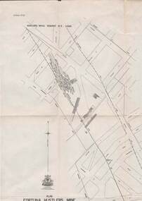
Map - STRUGNELL COLLECTION: HUSTLER'S LINE OF REEFS, BENDIGO, September 1913
... Map, Hustler's Line of Reefs, Bendigo, Plan Fortuna... Bendigo fortuna hustler's mine Underground Survey Office, Bendigo ...Map, Hustler's Line of Reefs, Bendigo, Plan Fortuna Hustler's Mine, Hustler's Royal Reserve No. 2 Lease. Plate No.1(1) Bulletin No 33 Signed H.A.Whitelaw.Underground Survey Office, Bendigo.map, bendigo, fortuna hustler's mine -
 Bendigo Historical Society Inc.
Map - STRUGNELL COLLECTION: HUSTLER'S LINE OF REEFS, September 1913
Map, Hustler's Line of Reefs, Hustler's Reef & Hustler's Reef No.1 Mines Plan.Plate No. XV1.(16) Sheet 2 .Bulletin No 33 Signed H.A.Whitelaw.Underground Survey Office, Bendigo, September,1913. Included is the emblem of the Geological Survey of Victoria. Drawing shows a plan view of reefs and shaft locations .Underground Survey Office, Bendigomap, bendigo, hustler's reef & hustler's reef 1 -
 Bendigo Historical Society Inc.
Newspaper - LYDIA CHANCELLOR COLLECTION: BILLMAN FAMILY
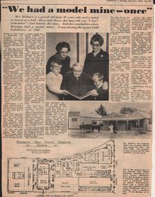
An article titled 'We had a model mine - once.' This is an interview with Mrs. E. Billlman from a 'Supplement to Bendigo Advertiser.' Mrs. Billman talks about the Gold Exhibition held in Bendigo in 1901. She also gives some insights into her family and the history of Bendigo. There are two photographs and a ground plan of the Victorian Gold Jubilee Exhibition. 30/7/1970's.bendigo, history, gold mining, lydia chancellor collection, collection, bendigo, history, mrs. e. billman, female, individual, person, victorian gold jubilee exhibition, great gold exhibition, model mine -
 Bendigo Historical Society Inc.
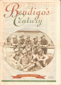
Newspaper - LONG GULLY HISTORY GROUP COLLECTION: BENDIGO'S CENTURY VOLUME FIVE: 1940 - 1949
Newspaper supplement titled Bendigo's Century Volume Five: 1940 - 1949. Each year has heading of Who's Who, Weather, Sport and Business. Front page is titled Bendigo's Century and has a photo of a group of soldiers in uniform and with rifles. They were district servicemen on leave in 1944. Each year has heading of Who's Who, Weather, Sport and Business. First years are 1940 - 1949 titled Bendigo as it was. It has two photos of women wading through the 1949 Pall Mall flood waters and one of Miners in the crib room of the Central Deborah Mine. They are Jackie Lewis, Bob Johnson, W Landy, Ryga Yates and Les Johnson. 1940 - Army moves in to racecourse, 1941 - Devastating fire at pottery, 1942 - Forces expand, 1943 - Nation's eyes on Bendigo, 1944 - News dawns of D-day landing, 1945 - City cheers the end of the war, 1946 - Celebrations begin in city, 1947 - Gallery gets top paintings, 1948 - Water plan looks good and 1949 - Flood takes a toll on city.bendigo, history, long gully history group, the long gully history group - bendigo's century - volume five: 1940 - 1949, bendigo advertiser, central deborah mine, jackie lewis, bob johnson, w landy, ryga yates, les johnson, central nell gwynne, department of defence, bendigo jockey club, 8th division, robert menzies, deborah mine, bendigo decentralisation vigilance committee, cr w h taylor, bendigo war funds organisation, the easter fair society, bendigo agricultural show committee, mr e g ham, mr j v fairbairn, cr a staples, the bendigo chamber of commerce, richard hartley smith abbott, captain harley abbott, bendigo art gallery, bill woodfull, bendigo high school, north deborah mine, boardwalk, toni riley pharmacy, windermere hotel, cr g a pethard, coliban system, north deborah mine, bendigo pottery, bendigo trades hall council, private lawrence burstall, major-general g j rankin mhr, andrew dunstan, ordnance factory, royal australian navy, hmas bendigo, sec offices, muioof, ymca, georger addlem, fred addlem, cr a j anderson, pauline buvhan thompson, leslie thompson, edward joseph leonski, bendigo football league, mr j dedman, william stephens, forest street methodist church, pte charles phillips, pte w e durward, pte t foley, william john stephens, central nell gwynne, air chief marshall sir arthur tedder, cr taylor, united nations, flying officer, r bruce tuff, flight lieutenant owens, royal air force, commonwealth war workers housing trust scheme, mr s mckinnon, bendigo decentralised vigilance committee, ravenswood estate, john lienhop mlc, margaret (peggy) brennan, strathfieldsaye shire council, school of mines, bendigo base hospital, william george ashman, ashman's tailors, bendigo jockey club, victorian football association, bendigo east swimming pool, deborah anticline, specimen hill methodist church, north deborah, adolf hitler, benito mussolini, australian 7th division, cr galvin, bendigo war funds organisation, hmas bendigo, lt-commander jackson, bendigo football league, central deborah mine, victoria day, cr truscott, bendigo gaol, lansellstowe, awas barracks, bendigo citizens committee, john cain snr, ordnance factory, bendigo agricultural society, the duke of gloucester, duchess of gloucester, bendigo tennis association, north deborah, gillies famous pies, aids & appliance shop, mrs georgina scott, dr j a neptune scott, alfred sisley, corot, daubigney, louis sonnenberg, gas employees' union, john lienhop, soldier settlement commission, burnewang estate, king george vi, princess elizabeth, lt philip mountbatten, mr e j w herbert, ansett airways, reg ansett, most rev, dr john mccarthy, dr bernard stewart, michael giudice, bendigo united breweries, bendigo lyric photo plays, bendigo sun newspaper, shamrock hotel, west bendigo progress association, alan mcdonald, south bendigo football club, albert collier, j t webbo, mervyn tresize, state rivers and water supply commission, eppalock reservoir, public works committee, bendigo rotary club, john edgar, bendigo base hospital, albert dunstan, benevolent home, magetti's wine hall, wallace reef wine hall, magetti family, albert magetti, lance galvin, bradford cotton spinnings (victoria) pty otd, arthur syer, stanley crossman, albert arthur dunstan, rev dr henry backhaus, city family hotel, lyric theatre, bank of australasia, city club hotelcolonial mutual building, r matchett & co, lansellstowe, leonard lansell, bendigo bas hospital, australian women's army service, mr hollway, kenworth (aust) ltd, foggitt jones's bacon factory, gordon sayers, sandhurst trustees, dr john drowley, alexander hislop, royal mint, north deborah mine, ironbark south mining company, central nell gwynne company, new chum syncline -
 Bendigo Historical Society Inc.
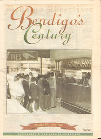
Newspaper - LONG GULLY HISTORY GROUP COLLECTION: BENDIGO'S CENTURY VOLUME SIX: 1950 - 1959
... Bendigo. 1957 - State Cabinet visits Bendigo. 1958 - Plan... - State Cabinet visits Bendigo. 1958 - Plan to keep historic mine ...Newspaper supplement titled Bendigo's Century Volume six: 1950 - 1959. Front page has a photo of Gillies' famous corner, 1954. Each year has heading of Who's Who, Weather, Sport and Business. First year is 1950 titled Gillies: it's a Bendigo icon. 1951 is titled It's party time. 1952 - City mourns King George. 1953 - Mining ceases. 1954 - City thrilled at royal visit. 1955 - Push to save old Joss House. 1956 - Olympic fever grips Bendigo. 1957 - State Cabinet visits Bendigo. 1958 - Plan to keep historic mine. 1959 - Water storage woes solved. Back page has the Gillies Story.bendigo, history, long gully history group, the long gully history group - bendigo's century - volume six: 1950 - 1959, gillies' corner, bendigo advertiser, john lienhop mlc, north deborah mine, les gillies, alan gillies, norm gillies, black swan hotel, sir dallas brooks, cr a g weynton, bert mundy, cr poulston, the northern district school of nursing, lister house, the bendigo free library, rev dr c irving, shamrock hotel, sir albert dunstan, the most rev dr john mccarthy, jack davey, 1950 empire games, hercules gold mines, amy castles, ben templeton, cobb & co, cr norman oliver, reg parker, fred amer, les hammer, colonel george victor lansell, john quick, mr l w galvin, mr p j clarey mhr, hanro knitting mills, flooding, bendigo pottery, snow fall, the last lamp-lighter, the north deborah, aids & appliance shop, boardwalk, the late king george vi, the north deborah, beehive building, st paul's, st kilian's, upper reserve, bendigo trades hall, bendigo blackout, bendigo hospital, shamrock hotel, gerald smith, britannia hotel, mr a j harris, william morris (billy) hughes, andrew hampson, deborah anticline, north deborah, central deborah, diamond hill mine, north nell gynne mine, robert ross haverfield, sandhurst commercial courier, arthur moore lloyd, robert ross haverfield, angus mackay, jj casey, james henderson, david stuart, bendigo independent, colonel george lansell, bendigo base hospital, bendigo town hall, victorian electric traction association, the most rev b d stewart, st vincent's memorial college, commonwealth athletic club, south atlas racetrack, harp and shamrock hotel, mr and mrs f drake, cr f w clayton, cr r poulston, j h abbott & co, sir george lansell, clan macleod, bendigo gaol, queen alexandra fountain, belfast hotel, commonwealth bank, st vincent's college, lyric threatre, des duguid, brian cahill, lord's raceway, red white & blue extended gold mining company nl, central napoleon gold miningcompany nl, joss house, harry john, bendigo advertiser, mr leggatt, university of melbourne, anz bank, golden drive-in theatre, bank of australasia, john brown industries, bendigo football league, bendigo trotting club, faith leech, racv, bendigo sewereage authority, bendigo base hospital, bendigo benevolent asylum, henry bolte, jack davey, russell oakley, neville stilwell, channel seven, bendigo's olympic pool, annie caudle centre, strathfieldsaye aerodrome committee, southern airlines, cr d j osborn, cairn curran reservoir, state savings bank, commonwealth bank of australasia, belfast hotel, bennett's arcade, eppalock weir, bendigo cenotaph, sir edmund herring, cr a s craig, bendigo creche, bendigo high school, bendigo pottery, shamrock hotel, the venerable ronald richards, bishop riley, all saints cathedral, mr albert bush, bendigo arcade company ltd, woolworths, bull's head hotel, pike's corner, arcade hotel, upper coliban reservoir, cr tom flood, crystal egg co, sailor's guide, central deborah, central nell gwynne mine, bendigo benevolent home, ron masters, george daniel, eppalock dam, water commission, public works committee, bendigo central victoria telecasters ltd, channel nine, royal princess theatre, sir george lansell, volunteer defence corps, bendigo independent, countess erna cadorin, count ettore cadorin, ernst mueller, sutex pty ltd, dick turner, marco cavasassi -
 Bendigo Historical Society Inc.
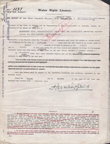
Document - MCCOLL, RANKIN AND STANISTREET COLLECTION: INDENTURE NO. 1137, 1936/51
Document: Monument Hill Consolidated (Bendigo) N/L 1137 water right licence 10/3/1936. Plan included. Re New Monument lease WR 1137 expires 10th March 1951. Not to be renewed.Pinned to document. Licence transferred to New Monument Gold Mining Co N.L. George Brown Secretary of Mines 10/10/1939. Transfer written in reds signature …MCCOLL RANKIN & STANISTREETorganization, business, gold mine licence., mccoll rankin & stanistreet -
 Bendigo Historical Society Inc.
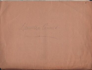
Document - MCCOLL, RANKIN AND STANISTREET COLLECTION: LANSELLS CONCORD GOLD MINING, 1934/1939
Documents: folder contains - Prospectus, Rent notices from Dept. of Mines, draft notes for prospectus, Dept. Mines, suspension of the Labour Covenant Lease No. 10024 Bendigo for three months expired 24/10/1934, application for shares forms, correspondence with Dept. of Mines re : Lease 10024, correspondence re Lease 10819, plans for Lease No. 10554, 10024, Dept letter - lease 10819 covers area of lease 10024, prospectus and plan of Bendigo Goldfields showing Lansells Concord Leases.MCCOLL RANKIN AND STANSISTREETorganization, business, gold mining, mccoll rankin and stansistreet, lansells concord gold mining. -
 Bendigo Historical Society Inc.
Document - MCCOLL, RANKIN AND STANISTREET COLLECTION: NORTH DEBORAH MINING CO, 1947
Document. Envelope contains:- Particulars of 24'' cylinder Winding Engine taken out of Great Southern Mine, Layout of Holding Down Bolts.McColl, Rankin & Stanistreetorganization, business, gold mine, mccoll, rankin & stanistreet, north deborah mining company nl, gold mining, ground plan re great southern 24'' winders. roy & toma contractors, campbell street, eaglehawk. -
 Bendigo Historical Society Inc.
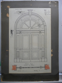
Artwork,other - NORMAN PENROSE COLLECTION: SCHOOL OF MINES - LIBRARY DOOR
Artwork. Norman Penrose collection: pen and ink drawing of ornate double doors of the School of Mines Library. Also has small section plans of various parts. Red and blue colouring where there are masonry walls. Mounted in cardboard with grey matt. Architectural Drawing for Drawing Teachers Secondary Certificate. Norman W. PenroseN Penrosedrawing, pencil, school of mines, norman penrose collection, artwork, school of mines library door -
 Bendigo Historical Society Inc.
Document - MCCOLL, RANKIN AND STANISTREET COLLECTION: NORTH VIRGINIA GMC N L - CROSS SECTION PLAN OF THE MINE, 1942 1947
... GMC N L - CROSS SECTION PLAN OF THE MINE... COLLECTION: NORTH VIRGINIA GMC N L - CROSS SECTION PLAN OF THE MINE ...Document. Grey/green exercise book with 'North Virginia GMC NL. Book contains hand drawings of shafts and their metalurgical content at every depth. Symbols have been used to indicate different metals and earth. 2 maps loose in the book.McColl, Rankin & Stanistreetorganization, business, north virginia gmc n l, mccoll, rankin & stanistreet, north virginia gmc n l, gold mining, cross section plan of the north virginia -
 Bendigo Historical Society Inc.
Document - NORMAN PENROSE COLLECTION: GENERAL DESIGN NOTES
Document. Norman Penrose collection: light brown folder with dark brown spine and corners. Contains lesson plans, 2 colour charts, drawings, 2 sheets of blue paper, pictures of 3 paintings/drawings, lettering and pictures of silhouettes glued onto cardboard.education, tertiary, bendigo school of mines, norman penrose collection, general design notes -
NMIT (Northern Melbourne Institute of TAFE)
Book: Furniture and equipment layouts for TAFE colleges Victoria. 1981
A4 size loose pages published by the Public Works Department and the Education Department Victoria in 1981. The contents cover the following Colleges: Moorabin, Dandenong, Collingwood, Newport, Box Hill, Sunraysia, Yallourn, Footscray, RMIT, Preston, School of Mines & Industries Ballarat, McMillan Rural Studies, Loddon Valley Bendigo, Wangaratta and Latrobe Street Complex. Plans and diagrams included.manuals, tafe colleges, preston technical college, collingwood tedhnical college, nmit -
 Bendigo Historical Society Inc.
Document - MCCOLL, RANKIN AND STANISTREET COLLECTION: DEBORAH GOLD MINE NL - LEASE DOCUMENTS, 1935, 1941
Document: McColl, Rankin and Stanistreet: lease documents. 12 pages of lease details, with attached map plan on no 9672 Bendigo. ( Abel and Eve Street marked )organization, mining, deborah gold mines nl, mccoll, rankin and stanistreet: deborah gold mines nl, gold mining, lease -
 Bendigo Historical Society Inc.
Document - MCCOLL, RANKIN AND STANISTREET COLLECTION: ANGOVE AND CARRS LEASE, DIAMOND HILL, 1935
McColl Rankin & Stanistreet, Angove & Carrs Lease, Diamond Hill. a/ Manila folio Markings: Angove & Carrs Lease Diamond Hill. Freed?aus Extended. b/ Plan Area Applied For On Lease No. 10103 Ben. By A A Macintosh. Mining District of Bendigo Parish of Mandurang County of Bendigo. Inscriptions: G Birch advises 16/5/35. Survey made by Assistant he has yet to receive. 10710 W J Angove - Spring Gully PO. Dated August 12th 1933 signed: Garnet G Birch J Victor Buley. c/ Agreement of lease for 1 month with the option of 9 months, followed by the option of purchase between Summerhill Anticlines NL of Adelaide and Angove & Carr at German Gully (Mandurang). Markings: 25/3/13 note by Summerhill Anticline NL. Requests information as to whether or not the Syndicate (E Mann, W Angove & H Irvine, H. Mc……….) desire to take up the options of lease or not. d/ Notice to Shareholders of a meeting in Collins Street Melbourne. 6 March, 1935 to consider proposals of the future of the company. J G Stanfield & Stewart, Manager. e/ Neangar Gold Mining Company NL 6 Month Report 27/2/1935 Business, Director's Report & Financial Report. f/ Report by A J J Moore BCE Mining Engineer, Ramrod Lease, Golden Fleece Mine near Spring Gully Reservoir the most Southern mine being Worked in Bendigo. Lease in on the Carshalton line. Report details the progress of the workings at the mine.organization, business, gold mine, mccoll rankin & stanistreet, angove & carrs lease, diamond hill a a macintosh parish of mandurang county of bendigo w j angove august 12th 1933 summerhill anticlines 6 month report 27/2/1935 golden fleece mine near spring gully reservoir -
 Bendigo Historical Society Inc.
Document - MCCOLL, RANKIN AND STANISTREET COLLECTION: SOUTH DEBORAH GOLD MINES NL GOLD LEASE DOCUMENT, 14/1/1941
Document: McColl, Rankin and Stanistreet - South Deborah Gold Mines NL. Gold mining lease document. No. 11141, Vol. 325, Fol. 35893. Lease adjoins Railway Reserve, Breen Street. Attached to plan with pin piece of paper, written in pencil ' application Atherton 14/4/46 - consent refused - hand drawn map with Honeybone Street.organization, mining, south deborah gold mines nl, mccoll, rankin and stanistreet, south deborah gold mines nl, gold mining lease documents -
 Bendigo Historical Society Inc.
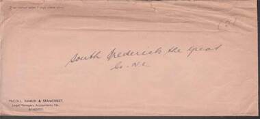
Document - MCCOLL, RANKIN AND STANISTREET COLLECTION: SOUTH FREDERICK THE GREAT CO NL, 1934
... ORGANIZATION Business gold mine Plan Of Area For On Lease No. 10287 Ben ...McColl Rankin & Stanistreet, South Frederick the Great Co NL. a/ Plan of Residence Areas on No. 10287, by J O Charlton, Parish of Yarraberb. Includes land for school, owners names of blocks, crown land. Signed: Garnet G Birch. Dated 27/4/1935, licensed surveyor. b/ Letter from Department of Mines to McColl Rankin & Stanistreet in reference to letter regarding lease No. 10287. On back of letter are notes relating to blocks of land on lease No.10287. c/ Plan Of Area For On Lease No. 10287 Ben. By John O Charlton. Mining District of Bendigo, Parish of Yarraberb, Lease No. 10287 Ben. By John O Charlton. Mining District of Bendigo. Date 21/6/1934. Signed Garnet G Birch. Blocks include name of purchaser. d/ Plan Of Area For On Lease No. 10287 Ben. By John O Charlton. Mining District of Bendigo, Parish of Yarraberb, County of Bendigo. Dated 21/6/1934. e/ envelope inscribed South Fredrick the Great. 51.organization, business, gold mine, plan of area for on lease no. 10287 ben. by john o charlton. mining district of bendigo, parish of yarraberb, county of bendigo j o charlton garnet g birch department of mines lease no. 10287 ben. by john o charlton mining district of bendigo 1934 -
 Bendigo Historical Society Inc.
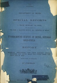
Book - UNDERGROUND SURVEY OF MINES, BENDIGO GOLDFIELD 1901, 1901
UNDERGROUND SURVEY OF MINES, BENDIGO GOLDFIELD 1901. Report on the Shamrock, Shenandoah, New Chum Railway, Eureka Extended, and South Belle Vue United Mines, New Chum Line of Reef. With plans and sections.H.S. Whitelawbendigo, hospital, gold mining, bendigo, goldfields, gold mining, shamrock, shenandoah, new chum railway, eureka extended, and south belle vue united mines, new chum line of reef. -
 Bendigo Historical Society Inc.
Book - ANNUAL REPORT OF THE SECRETARY FOR MINES AND WATER SUPPLY, c1896
Annual Report For The Secretary For Mines And Water Supply, Victoria 1895. Publisher: Government Printer, Melbourne. 86 pages. Plans & drawings.victoria, victorian mining report, mining machinery mine safety mining statistics -
 Bendigo Historical Society Inc.
Book - ANNUAL REPORT OF THE SECRETARY FOR MINES AND WATER SUPPLY, c1886
Annual Report Of The Secretary For Mines And Water Supply, Victoria. Publisher: Government Printer, Melbourne. 122 pages. Plans & drawings.victoria, mines and water supply, mining machinery, mine safety, mining statistics, regulation inspection 1885 -
 Bendigo Historical Society Inc.
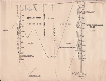
Document - MCCOLL, RANKIN AND STANISTREET COLLECTION: NAPOLEON REEF GOLD MINING CO. N.L, 1940
Document: 4 copies of plan of Transverse Section of Napoleon Anticline Lease no 10970, plan shows proposed shaft location and depth (1000 ft), for Napoleon Reef Gold Mining Co, also location and depth of adjacent Central Nell Gwynne Shaft scale 100ft = 1 inch, Prepared by J.J. Caldwell Mines Dept Bendigo.organization, business, industrial - mining, mccoll rankin & stanistreet, mining, gold mining, napoleon reef -
 Bendigo Historical Society Inc.
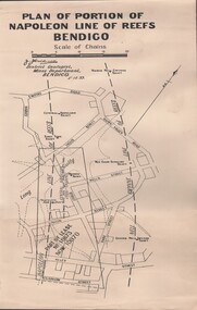
Document - MCCOLL, RANKIN AND STANISTREET COLLECTION: NAPOLEON REEF GOLD MINING CO. N.L, 5 December 1939
Document: 4 Copies of plans showing part of lease No. 10970 (was 10873) and Central Napoleon Lode Channel, prepared by J.J. Caldwell District Geologist, Mines Dept, Bendigo 5th Dec 1939.organization, business, industrial - mining, mccoll rankin & stanistreet, mining, gold mining, napoleon reef -
Bendigo Historical Society Inc.
Map - BIG 180 SHAFT POSITION, No date visible
... Bendigo mining plan Mining Gold Mines. Victoria Hill Big 180 Map ...Map: Plan showing the location of various shafts in the Victoria Hill area, hand draughted in pencil. Scale 2 Chains to 1 inchmap, bendigo, mining plan, mining , gold mines. victoria hill, big 180 -
 Bendigo Historical Society Inc.
Document - MCCOLL, RANKIN AND STANISTREET COLLECTION: NORTH HUSTLERS GMC - CORRESPONDENCE FILE, 1940 - 1969
Document. Bundle of letters, etc bound together with string. Reports for Annual General Meetings including profit & loss statements. Lists of shareholders. Proxy forms. Application for renewal of lease for North Hustlers Mine 9.4.1950. Prospectus for Hustlers Reef. Plan of residential area for application of lease.McColl, Rankin & Stanistreetorganization, business, north hustlers gmc, mccoll, rankin & stanistreet, north hustlers gmc, gold mining, lease, share holders, profit & loss, prospectus, agm -
Bendigo Historical Society Inc.
Map - BENDIGO GOLDFIELD, No date visible
... Bendigo mining plan Bendigo Goldfield Gold Mines Mining Map ...Map: Bendigo Goldfield. Scale 20 chains to 1 inch. Printed by Cambridge Press, Bendigo. (number 318 in map cupboard 1)map, bendigo, mining plan, bendigo goldfield, gold mines, mining -
 Bendigo Historical Society Inc.
Newspaper - LONG GULLY HISTORY GROUP COLLECTION: BENDIGO'S CENTURY VOLUME SEVEN: 1960 - 1969
Supplement to the Bendigo Advertiser, December 15, 1999 Volume Seven: 1960-1969 titled Bendigo's Century. The front has a photo of the BCV 8 Studio. Contains photos and local news, council matters, planning, Who's Who, Weather, Sport and Business and some Advertisements. Photos include Early stages in the construction of the Eppalock tower and bridge pillars, Christine Wiseman, TV8's first news reader Ron Alderton, Dr Albert L Beischer, Advertiser buiding, fire at the Advertiser building, Oscar Flight, Bendigo Town Hall, William Basil Ashman, Lake Eppalock, Premier Henry Bolte, Que O'Hoy, Sandhurst Guest House, The Lyric Theatre, E C Thompson, The elm tree in Market Square, Leslie Galvin, The original Myer Store, The Joss House, Sidney Myer, Bendigo Police Barracks, Bunratty Castle, Albert Vivian Gray, The Victoria Hill site, Architects drawing of the new council administrative offices and Noel Beaton MHR.bendigo, history, long gully history group, the long gully history group - bendigo's century volume seven: 1960 - 1969, bendigo advertiser, bcv 8, eppalock dam, premier henry bolte, the criterion hotel, mccarthy family, teachers training college, bendigo original teachers college, long gully state school, stramit, bendigo university site committee, mrs christine wiseman, bendigo city council, the broadcasting control board, general television pty ltd, bendigo central victoria telecasters pty ltd, mr davidson, bennett's arcade, woolworth's, white hills swimming pool, herb elliott, sailor's guide, toni riley pharmacies, rising sun hotel, ron alderton, dr albert l beischer, channel 8, melbourne herald, 3bo, bendigo advertiser officeslyceum theatre, junior technical school white hills, mount alvernia hospital, most reverend dr b d stewart, sisters of the franciscan missionaries of the divine motherhood, lazarus family, bendigo's tramways, state electricity commission, george pethard, lance pethard, bendigo advertiser fire 29/7/1962, riverine herald, the herald and weekly times, bendigo art gallery, oscar flight, hollands foundry, eaglehawk u.f.s. dispensary, gillies famous pies, william basil ashman, golden gate hotel, grieves family, bendigo town hall, mr r r anderson, mr e h brown, cr neville oliver, cr tom flood, traffic commission, lansell family, abev-1, bendigo ordnance factory, actu, bendigo trades hall council, the ramsay report, bendigo benevolent home, bendigo home and hospital for the aged, princess theatre, amoco, lake eppalock, bendigo training prison, bendigo police station lock-up, shamrock hotel, rifle brigade hotel, hopetoun hotel, anz bank, marong shire offices, sir rohan delacombe, st paul's church, que o'hoy, waldron family, windermere hotel, aids & appliance shop, anne caudle centre, e c thompson, mayfair hams, sandhurst guest house, lyric theatre, chinese joss house, ordnance factory, sir john jenson, bridge street chinese quarter, bendigo city hall, cr r f turner, cr tom flood, victorian inland meat authority, new zealand insurance co, mrtropolitan security service, bendigo easter fair society, golden square high school, eaglehawk high school, bendigo technical college, mr ralph w birrell, bendigo fountain plaza, the bethlehem home for the aged, dick hazeldene, victorian egg board, bendigo united cricket club, south bendigo united cricket club, western mining corporation, les priest, alexandra fountain, bendigo advertiser, cr w cambridge, bendigo council, eaglehawk council, strathfieldsaye shire, huntly shire, marong shire, david thomas, senator john gorton, bendigo's college of advanced education, bank of new south wales, harp and shamrock hotel, the honorable leslie william galvin, kurmala, cain government, hanro knitting mills, myer store, sidney myer, davey brothers grocery store, national trust, myer emporium, myer's ltd, cox bros (australia) ltd, dame merlyn myer, baillieu myer, frank greenaway, institute of technology, gas & fuel corporation, bendigo railway station, anz bank, city family hotel, tab branch, senior constable alfred herbert wright, senior constable allan raymond brown, victorian football league, bendigo police barracks, camp hill state school, state electricity commission, the country party, the labor party, transport regulation board, stuart anderson, grose family, jean theodore de ravin, kyneton shire, sir william mcdonald, mines department, the loddon hospitals region group laundry and central linen service, kevin wynne, albert vivian gray, bradford cotton mills ltd, bradmill industries ltd, victoria hill, bendigo and district tourist association, professor brian lewis, melbourne university, victorian chinese community, loong, sun loong, stafford ellinson, coles' store, north deborah mining company nl, noel beaton mhr, durham ox hotel, taylor family -
 Bendigo Historical Society Inc.
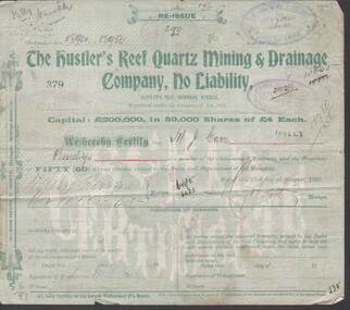
Document - KELLY AND ALLSOP COLLECTION: SHARE CERTIFICATES - HUSTLER'S REEF, IRONBARK, BENDIGO, 23/08/1902 to 25/01/1904
... . Each certificate is pale green in colour and has a plan... in colour and has a plan of the mine on the back. Printed ...Documents. KELLY & ALLSOP COLLECTION. A series of Share Certificates issued by The Hustler's Reef Quartz Mining & Drainage Company, No Liability. Each certificate represents 50 shares at 4 pounds each. Capital raised was 200 thousand pounds from 50,000 shares. Certificates No.379, 384 issued to M.J.Carr on 23 Aug 1902. Certificate No.400 issued to G.H.Pearce on 23 Aug 1902. Certificates No.1427 - 1433 issued to N.Lloyd on 28 Oct 1902. Certificates No. 2259 - 2265 issued to C.Millman on 10 Aug 1903. Certificates No.2714, 2715 issued to N.Lloyd on 25 Jan 1904. Each certificate is pale green in colour and has a plan of the mine on the back. Printed by J.B.Young, Bendigo. Certificates dated 1902 are signed by the Manager Henry Y North and later certificates signed by G Stanfield for the Manager. 19 certificates in total.Hustler's Reef Minebusiness, stockbroker, kelly & allsop, kelly & allsop collection, hustlers reef mine, share certificates, henry y.north, g.stanfield, m.j.carr, g.h.pearce, n.lloyd, c.millman -
Clunes Museum
Map, Surface Geology Plan
Plans show various shaft locations.1 Photocopy of Plan Block 23/19 Scale 1 inch = 100 feet .2 Photocopy of Plan Block 19/19 Scale 1 inch = 100 feet .3 AERIAL PHOTOGRAPH WITH WORKINGS MARKED - LAMINATED.1 C-21 North Broken Hill Ltd Clunes Block 23/19 .2SOUTH CLUNES MINE Ltd Clunes Block 19/19north broken hill ltd, surface geology plan -
Clunes Museum
Book, Percy, John, Percy's Metallurgy - Iron & Steel, 1894
Dowlais is a former Iron/steel making and coal mining town in Wales, United Kingdom.1 Hardcover book light brown embossed cover, gold lettering on spine, 1864, subject matter, the art of extracting metals from their ores and adapting them to various purposes of manufacture. With illustrations, chiefly from original drawings, carefully laid down to scale. .2 Newspaper Article "Dr. Percy on Iron and Steel" published in The Times Tuesday, May 17, 1864 .3 Plan for Dowlais New Mills Gold Lettering on spine: "Percy's Metallurgy Iron & Steel London John Murray Faded Maroon stamp page 2 - Clunes School of Mines No. 24 16 Jun 93metallurgy, mining