Showing 14773 items
matching north road
-
 Whitehorse Historical Society Inc.
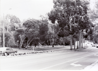
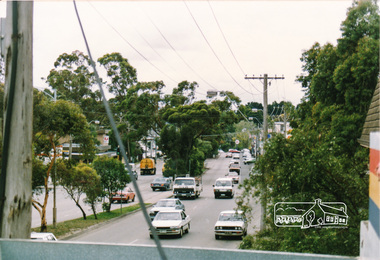
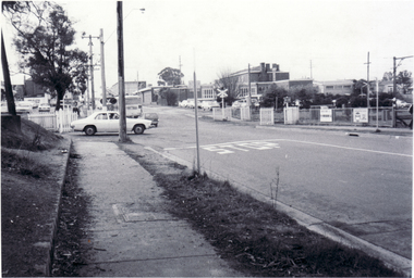
Photograph, Blackburn Road, Blackburn, 6/01/2001 12:00:00 AM
... looking north from Canterbury Road.... and white photograph of Blackburn Road Blackburn looking north from ...Black and white photograph of Blackburn Road Blackburn looking north from Canterbury Road.blackburn road, blackburn., canterbury road -
 Bayside Gallery - Bayside City Council Art & Heritage Collection
Map, Department of Crown Lands and Survey, Moorabbin, County of Bourke, c. 1918
... extends to North Road, Brighton at top.... Point (to the south) but the map extends to North Road, Brighton ...The cadastral map of the Parish of Moorabbin in Victoria (L.6104) shows parish boundaries and land ownership c. 1918 when Sandringham was a Borough.moorabbin, county of bourke, map, plan, land subdivision, land titles, foreshores, sndringham, hampton, beaumaris, highett, cheltenham, department of lands and survey, land owners, cartographic material, borough of sandringham, brighton -
 Ringwood and District Historical Society
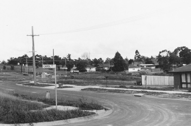
Photograph, Westward view along Jull Road from corner of Carol Court, North Ringwood - 1981
... , North Ringwood from Carol Court looking towards Oban Road... Road Ringwood North melbourne Written on back of photograph ...Written on back of photograph, "E621. N3. 1981. Jull Road, North Ringwood from Carol Court looking towards Oban Road. North Ringwood sports ground centre left". -
 Whitehorse Historical Society Inc.
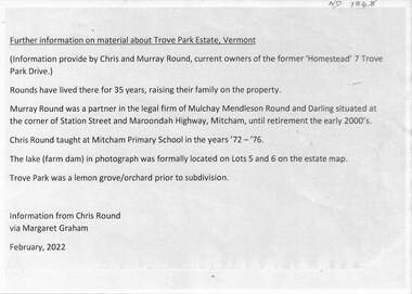
Document - Real estate notes, maps, flyers, Trove Park Estate, 1969, 2022
... . The Uplandas Estate was bordered by Canterbury road (north), Terrara.... The Uplandas Estate was bordered by Canterbury road (north), Terrara ...A history of the Trove Park Estate, Vermont from 1880's to 2022 is provided by notes, maps, pictures and auction flyers. The Estate was originally part of the Uplands Estate of 34 acres in the Mount Pleasant district.A history of the Trove Park Estate, Vermont from 1880's to 2022 is provided by notes, maps, pictures and auction flyers. The Estate was originally part of the Uplands Estate of 34 acres in the Mount Pleasant district.A history of the Trove Park Estate, Vermont from 1880's to 2022 is provided by notes, maps, pictures and auction flyers. The Estate was originally part of the Uplands Estate of 34 acres in the Mount Pleasant district.trove park drive estate vermont, mt pleasant, trove park, uplands vermont, bishop edward, round chris & murray, mulcahy mendelson & round, trove park drive vermont no 7 -
 Kew Historical Society Inc
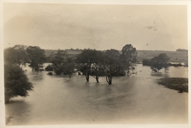
Photograph, Floods in North Kew, 1934
... ?) Willsmere Road, North Kew.... in North Kew, 1934. Flood near Lagoon (Billabong?) Willsmere Road ...The great flood of 1934 in Melbourne was one of the most devastating floods since records began. The floods affected all of Melbourne, including Kew.Locally significant photographs of the impact of flooding in Kew in 1934Floods in North Kew, 1934. Flood near Lagoon (Billabong?) Willsmere Road, North Kew.floods (kew) 1934, yarra river -
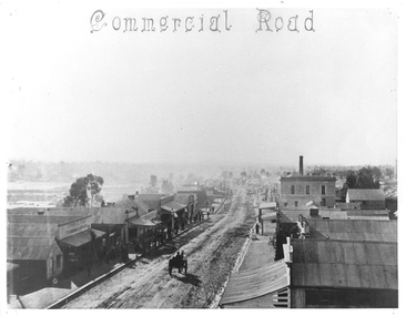 Tarnagulla History Archive
Photograph of Commercial Road, Tarnagulla, June 1866
... Monochrome photograph looking north down Commercial Road... Monochrome photograph looking north down Commercial Road, Tarnagulla ...Murray Comrie Collection. Copy of an 1866 photograph by Aimé Marchand. In June 1866, Aimé Marchand (1846-1910) made a series of fourteen photographs which were submitted to the 1866-67 Melbourne Intercolonial Exhibition, where they earned a 1st Class Honorable Mention. This is one of those fourteen images. Of French or Belgian origin and possibly formerly an assayer in California, Marchand appears to have begun his practice of photography in Tarnagulla around 1865 as an assistant to A.B. Clay. By the following year he had settled in Portland, where he opened the Royal Photographic Studio in Gawler Street. From his base in Portland he toured surrounding districts, offering portrait and view services. Little else is known about his life. He appears to have left Australia in 1878. A misprint of his name in a local directory as Annie Marchand created the misconception that he was one of only a few named women photographers in the colonies. Monochrome photograph looking north down Commercial Road, Tarnagulla from the roof of the Council Chambers. tarnagulla, views, burstall hall, council chambers, local government, commercial road, local people, residents, aimé marchand, photographers -
 Glen Eira Historical Society
Letter - Hawthorn Road, 566, Caulfield
... redevelopment for a Food Plus Store corner of Hawthorn Road and North... Road and North Road, South Caulfield. Current address is 566 ...Three paged letter dated 18/08/1980 from Food Plus Stores to City of Caulfield giving support factors re proposed redevelopment for a Food Plus Store corner of Hawthorn Road and North Road, South Caulfield. Current address is 566 Hawthorn Road, Caulfield.hawthorn road, caulfield, food stores plus, city of caulfield, petrol stations, shops, employment, commercial establishments -
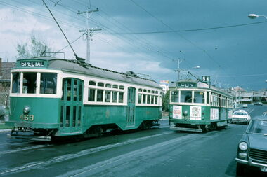 Melbourne Tram Museum
Slide - Y 469 & SW6 965 Hawthorn Road, Warren Doubleday, 2-10-1971
... at the intersection with North Road, with a Post Office and a milkbar... with North Road, with a Post Office and a milkbar in the view ...Set of two photos of Y class 469 on a tour in Hawthorn Road, East Brighton. The first is taken near the terminus of route 64, with SW6 965 northbound, and the second at the intersection with North Road, with a Post Office and a milkbar in the view, advertising Cambridge cigarettes. Dated 2-10-1971.Yields information about the use of Y469 on tours and Hawthorn Road.Set of two Kodachrome cardboard mounted slides.tramways, tramcars, y class, tram 469, sw6 class, tram 965, hawthorn road, east brighton -
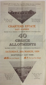 Kew Historical Society Inc
Plan - Subdivision Plan, Charteris Estate, East Ivanhoe, 1939
... Street, McArthur Road, Burke Road North, Charteris Drive... Boulevard, Castella Street, McArthur Road, Burke Road North..., McArthur Road, Burke Road North, Charteris Drive and Warncliff Road ...The Charteris Estate in Ivanhoe was sold in a number of sections. Copies of a subdivision plan of the first section is in the State Library of Victoria collection. This later section of the Charteris Estate includes lots in the Government Boulevard, Castella Street, McArthur Road, Burke Road North, Charteris Drive and Warncliff Road.Subdivision plans like that for the Charteris Estate are invaluable records for local historians identifying when lots in streets were promoted for sale.Four-fold brochure advertising the Charteris Estate in East Ivanhoe in 1939. Streets named on the plan include: the Government Boulevard, Castella Street, McArthur Road, Burke Road North, Charteris Drive and Warncliff Road. The brochure contains photos of Charterisville, the home of F De Castella Esq and also of attractive rolling hills. Annotations in pencilcharteris estate - east ivanhoe (vic), subdivision plans - east ivanhoe (vic) -
 Bayside Gallery - Bayside City Council Art & Heritage Collection
Photograph, Department of Crown Lands and Survey, Victoria, Brighton, Elwood and Elsternwick, c. 1965-71
... . The main roads shown include North Road at the top, Nepean Highway.... The main roads shown include North Road at the top, Nepean Highway ...The Department of Crown Lands and Survey (1857-1983) was responsible for the administration of survey and mapping and the sale, occupation and management of crown land throughout its existence. This aerial photograph shows parts of Brighton, Elwood and Elsternwick and was taken circa 1965-71.brighton, department of crown lands and survey, aerial photograph, bayside, port phillip bay, map, cartographic material, elwood, elsternwick, elsternwick park, elwood tram depot, elwood pier, new street, glen huntly road, st kilda street, nepean highway -
 City of Moorabbin Historical Society (Operating the Box Cottage Museum)
Clothing - Clothing, City of Moorabbin Tie, Circa 1960s
... Road, South to South Road and North to North Road and became... Road and North to North Road and became known as Brighton. 1859 ...The City of Moorabbin existed from 1934 until 1994. Henry Dendy's Special Survey in 1841 of 5,120 acres in the Parish of Moorabbin , extended from Port Phillip Bay , then East to Boundary Road, South to South Road and North to North Road and became known as Brighton. 1859 Brighton became a Borough with its boundary Thomas Street ,and Bluff Road. In 1862 The Moorabbin Roads Board was formed and the extended area now included Cheltenham, Hampton, Sandringham, Black Rock, Beaumaris, Mentone and Mordialloc .and Little Brighton became known as Bentleigh. In 1871 the area became known as The Shire of Moorabbin. Gradually the area was separated into The Borough of Sandringham 1917, ( Black Rock, Beaumaris , Sandringham and Hampton ) Borough of Mentone and Mordialloc 1920, ( Parkdale ). In 1934 The City of Moorabbin was established for the area from South East corner of Thomas Street and North Road , East to Warrigal Road, Clayton Road, Kingston Road , Lower Dandenong Road, then South along Nepean Highway to Balcombe Road and along Bluff Road, Cummins Road, Nepean Highway, Thomas Street to North Road In the 1994 Amalgamation of Councils the City of Moorabbin was divided between the new City of Kingston in the South ( from South Road) and the new City of Glen Eira to the North . It was the largest Municipality in Victoria with a population of 118,865 in 1974This tie c 1960 is a memento of the City of Moorabbin 1934 - 1994Maroon colour, polyester, man's tie with the crest of City of Moorabbin woven on front.around circle enclosing Coat of Arms ; CITY OF MOORABBIN city of moorabbin, moorabbin roads board, moorabbin, brighton, dendy's special survey 1841, early settlers, pioneers, market gardners, dendy henry, were jonathan b, cheltenham, bentleigh, mentone, sandringham, mair william, bent thomas -
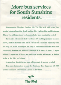 Melbourne Tram Museum
Ephemera, The Met, "More bus services for South Sunshine residents", 10/1987
... in 2024 is from South Sunshine to Gardenvale North Road.... South Sunshine to Gardenvale North Road. Demonstrates a notice ...Customer Bulletin - "More bus services for South Sunshine residents" advising that commencing Monday, Oct. 5 (1987) a trial service to South Sunshine, an extension of route 219. Gives times and a route map along with contact details Route 219 in 2024 is from South Sunshine to Gardenvale North Road.Demonstrates a notice advising bus services for route 219.Timetable Customer Bulletin A4 printed sheets, green ink on white paper.tramways, the met, timetables, buses, route 219, south sunshine -
Canterbury History Group
Photograph - 4 Victoria Avenue Canterbury, c1912
... View of 4 Victoria Avenue Canterbury looking north from...Canterbury History Group 190A Canterbury Road Canterbury ...View of 4 Victoria Avenue Canterbury looking north from Canterbury Road.[1912} sepia photographcanterbury, victoria avenue, roads and streets, street trees -
Canterbury History Group
Photograph - Balwyn Road, Canterbury looking north, c. 1909
... Balwyn Road, Canterbury looking north....Black and white photograph of Canterbury looking north up... photograph of Canterbury looking north up Balwyn Road from Logan ...Black and white photograph of Canterbury looking north up Balwyn Road from Logan Street c1909.canterbury, balwyn road, logan street, maling road, shops, street trees, canterbury gardens, duncan and weller -
 Greensborough Historical Society
Map, Melbourne and Metropolitan Board of Works. Survey Division, MMBW, Yarra 2500 / 13.26. Yarrambat, Worns Lane, 1978_02
... Road, North Oatlands Road and Licola Street. Features include... streets include: Worns Road, North Oatlands Road and Licola Street ...Melbourne and Metropolitan Board of Works. Yarra 2500 [base map] 13.26. Yarrambat, Worns Lane. Municipalities of Diamond Valley 257 and Whittlesea 239. Prominent streets include: Worns Road, North Oatlands Road and Licola Street. Features include Plenty River.MMBW Map in 1:2500 [scale] series. Cream parchment with green tape reinforcing on edges and punched holes on left edge.mmbw, melbourne and metropolitan board of works, shire of diamond valley, whttlesea, yarrambat - maps -
 Eltham District Historical Society Inc
Photograph, Main Road, Eltham
... Three photographs looking north along Main Road towards... looking north along Main Road towards Arthur Street near Eltham ...Three photographs looking north along Main Road towards Arthur Street near Eltham Shopping Centre.main road, arthur street, eltham, shops -
 Eltham District Historical Society Inc
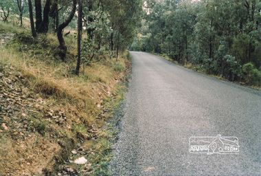
Photograph, Pound Bend Road, Warrandyte
... Five colour photographs showing Pound Bend Road, Warrandyte... photographs showing Pound Bend Road, Warrandyte North Pound Bend Road ...Five colour photographs showing Pound Bend Road, Warrandyte Northpound bend road, warrandyte, manningham -
 Whitehorse Historical Society Inc.
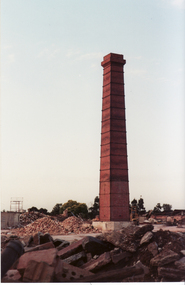
Photograph, Vitclay, 1995
... Road, Blackburn North.... Mitcham melbourne vitclay springfield road blackburn north ...Vitclay Chimney, prior to demolition in 1995. Springfield Road, Blackburn North.vitclay, springfield road, blackburn north, potteries, clay industries -
 Whitehorse Historical Society Inc.
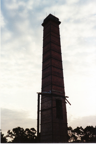
Photograph, Vitclay, 1995
... Road, Blackburn North.... Mitcham melbourne vitclay springfield road blackburn north ...Vitclay Chimney, prior to demolition in 1995. Springfield Road, Blackburn North.vitclay, springfield road, blackburn north, potteries, clay industries -
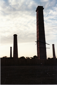 Whitehorse Historical Society Inc.
Photograph, Vitclay, 1995
... . Springfield Road, Blackburn North.... Mitcham melbourne vitclay springfield road blackburn north ...Vitclay Chimneys, prior to demolition in 1995. Springfield Road, Blackburn North.vitclay, springfield road, blackburn north, potteries, clay industries -
Stawell Historical Society Inc
Map, Roads Maintained by NGSC. Roads Maintained by Other Authorities, C 2020
... Printed Colour map of Norther Grampians Shire, with roads...Shire Roads Transport Norther Grampians Shire COuncil. 1 ...Printed Colour map of Norther Grampians Shire, with roads marked in colourNorther Grampians Shire COuncil. 1:200,000shire, roads, transport -
 Whitehorse Historical Society Inc.
Photograph - B/W Photograph, Railway Crossing Mitcham, 1/09/1976 12:00:00 AM
... Black and white photo of Railway Crossing, Mitcham Road... photo of Railway Crossing, Mitcham Road, looking north Railway ...Black and white photo of Railway Crossing, Mitcham Road, looking northmitcham road, mitcham, railway crossings -
 Eltham District Historical Society Inc
Slide - Photograph, Eltham Shire Council, Plan of Subdivision, Crown Allotment 8, Section 8A, Parish of Nillumbik,County of Evelyn, 1969
... C1, Pain, Sibbel and Carter, Research-Warrandyte Road...-Warrandyte Road, North Warrandyte, 4 August 1969 35mm colour positive ...35mm colour positive transparency blue Agfacolour Service plastic mountC1, Pain, Sibbel and Carter, Research-Warrandyte Road, North Warrandyte, 4 August 1969carter, infrastructure, map, north warrandyte, pain, parish of nillumbik, plan of subdivision, planning, research-warrandyte road, sibbel, subdivison lots -
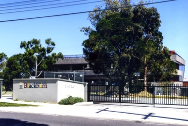 Whitehorse Historical Society Inc.
Photograph, Blackburn High School, 2012
... in Springfield Road facing north 2012... of the Blackburn High School in Springfield Road facing north 2012 ...The Blackburn High School opened on 1st February 1956 with 128 Form 1 pupils and a staff of 8. The 20-acre site on the corner of Williams and Springvale road was surrounded by orchards and pine trees. The trees inspired the school motto: ' Ad licem crescimus' - 'We are growing towards the light'. The first headmaster was Mr V. Percy. The school had a reputation for musical excellence.Coloured photograph of the Blackburn High School in Springfield Road facing north 2012blackburn high school, schools -
 Whitehorse Historical Society Inc.
Photograph - B/W Photograph, Shops Whitehorse Road Mitcham taken from the back, 1/09/1976 12:00:00 AM
... Black and white photo of back of shops on north side... of back of shops on north side of Whitehorse Road, Mitcham Shops ...Black and white photo of back of shops on north side of Whitehorse Road, Mitchamshops mitcham, whitehorse road mitcham -
 Greensborough Historical Society
Map, Melbourne and Metropolitan Board of Works. Survey Division, MMBW, Yarra 2500 / 14.27. Yarrambat, Yan Yean Road, 1978_04
... streets include: Yan Yean Road, North Oatlands Road and Pioneer..., North Oatlands Road and Pioneer Road. Features include Yarrambat ...Melbourne and Metropolitan Board of Works. Yarra 2500 [base map] 14.26. Yarrambat, Yan Yean Road. Parishes of Morang 3183 and Greensborough 2724. Municipality of Diamond Valley 257. Prominent streets include: Yan Yean Road, North Oatlands Road and Pioneer Road. Features include Yarrambat War Memorial Reserve.MMBW Map in 1:2500 [scale] series. Cream parchment with green tape reinforcing on edges and punched holes on left edge.mmbw, melbourne and metropolitan board of works, shire of diamond valley, whttlesea, yarrambat - maps -
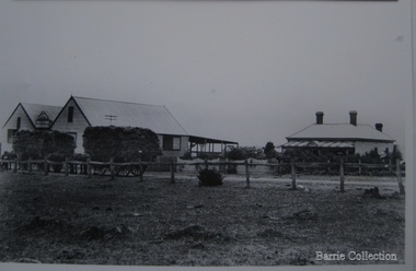 Melton City Libraries
Photograph, Chaff cutting and hay-pressing mills, 1909
... of Station Road in Melton South, 100 metres north of Brooklyn Road... on the west side of Station Road in Melton South, 100 metres north ...In the early 1900’s Charles Ernest Barrie and his brother Ted were in partnership in a Chaff cutting and Ha y processing Mill on the corner of Station and Brooklyn road Melton South. By 1906 Charles Ernest and James Edwin were in partnership in the Station Road mill when a connecting rail line across Brooklyn Road for a siding was constructed to the Melton Railway Station. In 1911 the Mill’s letterhead shows C.E. BARRIE Hay Pressing and Chaff Cutting Mills. This Mill as sold to H S K Ward in 1916 and stood until 1977 when it burnt down in a spectacular fire.Owned by C.E Barrie. Buildings were on the west side of Station Road in Melton South, 100 metres north of Brooklyn Roadlocal identities, pioneer families, agriculture -
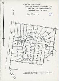 Ringwood and District Historical Society
Map - Plan of Subdivision, Part of Crown Allotment 27B Parish of Warrandyte County of Bourke (undated, circa 1970)
... in Glenvale Road, Cantala Crescent, and Giana Court, north of Kubba... in Glenvale Road, Cantala Crescent, and Giana Court, north of Kubba ...Photocopied subdivision map of 38 residential allotments in Glenvale Road, Cantala Crescent, and Giana Court, north of Kubba Road, Ringwood. -
 Eltham District Historical Society Inc
Photograph, R.H. Luxmoore, Painting, 'The Hawthorns', R.H. Luxmoore, 1919, 2/2/19
... Situated at the north corner of Main Road and John Street...Located on the north corner of Main Road and John Street... melbourne Situated at the north corner of Main Road and John Street ...Situated at the north corner of Main Road and John Street, Eltham; 'The Hawthorns' was the home of T.N. Jewell and his wife, 'Polly' Margaret Jewell (nee White). Painted by R.H. Luxmoore a boarder at the house. Polly Jewell was the aunt of current painting owner (Keith Johnson). Doug Orford's mother would visit her at the home every week.Located on the north corner of Main Road and John Street, Eltham; 'The Hawthorns' was the home of T.N. Jewell and his wife, 'Polly' Margaret White. Most likely viewed from location of where Methodist Church Hall was situated.eltham, the hawthorns, main road, john street, t.n jewell, polly margaret white, r.h luxmoore