Showing 6473 items
matching photo series
-
 St Kilda Historical Society
Photograph - Photo map, 08/02/1966
... One of a series of photo-maps produced for the Department... Carlisle Street St Kilda melbourne One of a series of photo-maps ...One of a series of photo-maps produced for the Department of Crown Lands and Survey (1857-1983). For correlation with a current map, and access to other historical photo maps of Victoria, see the Historic Photo-Maps Index published by the Department of Environment, Land, Water and Planning at https://services.land.vic.gov.au/DELWPmaps/historical-photomaps/Black and white aerial photographVic 1916 Melbourne 1966 Project Run 13 E 8.2.66 Lens 122 151.75MM 9.800 111st kilda, balaclava, caulfield, caulfield north, st kilda east, elsternwick, elsterwick park, elwood park, elwood canal, elwood beach, ripponlea, 1966 -
 St Kilda Historical Society
Photograph - Photo map, 11/01/1968
... One of a series of photo-maps produced for the Department... Carlisle Street St Kilda melbourne One of a series of photo-maps ...One of a series of photo-maps produced for the Department of Crown Lands and Survey (1857-1983). For correlation with a current map, and access to other historical photo maps of Victoria, see the Historic Photo-Maps Index published by the Department of Environment, Land, Water and Planning at https://services.land.vic.gov.au/DELWPmaps/historical-photomaps/Black and white aerial photographVic 2132 State Aerial Survey Melbourne 1968 Proj Run 27E 11.1.68 5100 ASL 65caulfield north, caulfield park, armadale, malvern, 1968 -
 St Kilda Historical Society
Photograph - Photo map, 11/01/1968
... One of a series of photo-maps produced for the Department... Carlisle Street St Kilda melbourne One of a series of photo-maps ...One of a series of photo-maps produced for the Department of Crown Lands and Survey (1857-1983). For correlation with a current map, and access to other historical photo maps of Victoria, see the Historic Photo-Maps Index published by the Department of Environment, Land, Water and Planning at https://services.land.vic.gov.au/DELWPmaps/historical-photomaps/Black and white aerial photographVic 2132 State Aerial Survey Melbourne 1968 Proj Run 27E 11.1.68 5100 ASL 67st kilda east, st kilda cemetery, caulfield north, alma park, balaclava, armadale, 1968 -
 St Kilda Historical Society
Photograph - Photo map, 13/01/1968
... One of a series of photo-maps produced for the Department... Carlisle Street St Kilda melbourne One of a series of photo-maps ...One of a series of photo-maps produced for the Department of Crown Lands and Survey (1857-1983). For correlation with a current map, and access to other historical photo maps of Victoria, see the Historic Photo-Maps Index published by the Department of Environment, Land, Water and Planning at https://services.land.vic.gov.au/DELWPmaps/historical-photomaps/Black and white aerial photograph2138 State Aerial Survey Melbourne 1968 Proj. Run 26 13.1.68 5100 ASL 203st kilda west, albert park, fawkner park, south yarra, prahran, windsor, 1968 -
 St Kilda Historical Society
Photograph - Photo map, 11/01/1968
... One of a series of photo-maps produced for the Department... Carlisle Street St Kilda melbourne One of a series of photo-maps ...One of a series of photo-maps produced for the Department of Crown Lands and Survey (1857-1983). For correlation with a current map, and access to other historical photo maps of Victoria, see the Historic Photo-Maps Index published by the Department of Environment, Land, Water and Planning at https://services.land.vic.gov.au/DELWPmaps/historical-photomaps/Black and white aerial photographVic 2132 State Aerial Survey Melbourne 1968 Proj. Run 27E 11.1.68 5100 ASL 69st kilda, albert park, st kilda east, st kilda beach, alma park, windsor, prahran, 1968 -
 St Kilda Historical Society
Photograph - Photo map, 11/01/1968
... One of a series of photo-maps produced for the Department... Carlisle Street St Kilda melbourne One of a series of photo-maps ...One of a series of photo-maps produced for the Department of Crown Lands and Survey (1857-1983). For correlation with a current map, and access to other historical photo maps of Victoria, see the Historic Photo-Maps Index published by the Department of Environment, Land, Water and Planning at https://services.land.vic.gov.au/DELWPmaps/historical-photomaps/Black and white aerial photographVic 2132 State Aerial Survey Melbourne 1968 Proj. Run 28E 11.1.68 5100 ASL 81st kilda, balaclava, st kilda east, ripponlea, elwood, elsternwick, caulfield, st kilda botanical gardens, 1968 -
 St Kilda Historical Society
Photograph - Photo map, 11/01/1968
... One of a series of photo-maps produced for the Department... Carlisle Street St Kilda melbourne One of a series of photo-maps ...One of a series of photo-maps produced for the Department of Crown Lands and Survey (1857-1983). For correlation with a current map, and access to other historical photo maps of Victoria, see the Historic Photo-Maps Index published by the Department of Environment, Land, Water and Planning at https://services.land.vic.gov.au/DELWPmaps/historical-photomaps/Black and white aerial photographVic 2132 State Aerial Survey Melbourne 1968 Proj. Run 29E 11.1.68 5100 ASL 194elwood, elwood beach, elwood park, elsternwick park, ripponlea, elwood canal, balaclava, st kilda, 1968 -
 St Kilda Historical Society
Photograph - Photo map, 11/01/1968
... One of a series of photo-maps produced for the Department... Carlisle Street St Kilda melbourne One of a series of photo-maps ...One of a series of photo-maps produced for the Department of Crown Lands and Survey (1857-1983). For correlation with a current map, and access to other historical photo maps of Victoria, see the Historic Photo-Maps Index published by the Department of Environment, Land, Water and Planning at https://services.land.vic.gov.au/DELWPmaps/historical-photomaps/Black and white aerial photographVic 2132 State Aerial Survey Melbourne 1968 Proj. Run 27E 11.1.68 5100 ASLst kilda, st kilda west, st kilda pier, catani gardens, st kilda beach, albert park, 1968 -
 St Kilda Historical Society
Photograph - Photo map, 11/01/1968
... One of a series of photo-maps produced for the Department... Carlisle Street St Kilda melbourne One of a series of photo-maps ...One of a series of photo-maps produced for the Department of Crown Lands and Survey (1857-1983). For correlation with a current map, and access to other historical photo maps of Victoria, see the Historic Photo-Maps Index published by the Department of Environment, Land, Water and Planning at https://services.land.vic.gov.au/DELWPmaps/historical-photomaps/Black and white aerial photographVic 2132 State Aerial Survey Melbourne 1968 Proj. Run 29E 11.1.68 5100 ASL 196elwood, elwood park, elwood canal, elwood beach, st kilda marina, mc moran reserve, point ormond, 1968 -
 St Kilda Historical Society
Photograph - Photo map, Department of Crown Lands and Survey (1857-1983), 22/01/1970
... One of a series of photo-maps produced for the Department... Carlisle Street St Kilda melbourne One of a series of photo-maps ...One of a series of photo-maps produced for the Department of Crown Lands and Survey (1857-1983). For correlation with a current map, and access to other historical photo maps of Victoria, see the Historic Photo-Maps Index published by the Department of Environment, Land, Water and Planning at https://services.land.vic.gov.au/DELWPmaps/historical-photomaps/Black and white aerial photographVic 2358 Department of Crown Lands and Survey Victoria,.© Melbourne 1970 Project Run 41E 22.1.70 5,100 ASL 62caulfield, caulfield north, st kilda east, armadale, 1970 -
 St Kilda Historical Society
Photograph - Photo map, 14/12/1963
... One of a series of photo-maps produced for the Department... Carlisle Street St Kilda melbourne One of a series of photo-maps ...One of a series of photo-maps produced for the Department of Crown Lands and Survey (1857-1983). For correlation with a current map, and access to other historical photo maps of Victoria, see the Historic Photo-Maps Index published by the Department of Environment, Land, Water and Planning at https://services.land.vic.gov.au/DELWPmaps/historical-photomaps/Black and white aerial photographVic 1807 Melbourne 1963 Project Run 17 14.12.63 Lens 205 152.70 M/M 5.150 36st kilda, st kilda botanical gardens, balaclava, st kilda east, elwood canal, ripponlea, caulfield north, elwood, caulfield, 1963 -
 St Kilda Historical Society
Photograph - Photo map, Department of Crown Lands and Survey (1857-1983), 22/01/1970
... One of a series of photo-maps produced for the Department... Carlisle Street St Kilda melbourne One of a series of photo-maps ...One of a series of photo-maps produced for the Department of Crown Lands and Survey (1857-1983). For correlation with a current map, and access to other historical photo maps of Victoria, see the Historic Photo-Maps Index published by the Department of Environment, Land, Water and Planning at https://services.land.vic.gov.au/DELWPmaps/historical-photomaps/Black and white aerial photographVic 2358 Department of Crown Lands and Survey Victoria,.© Melbourne 1970 Project Run 42E 22.1.70 5,100 ASL 77st kilda, st kilda east, st kilda marina, elwood, elwood canal, elsternwick park, point ormond, balaclava, mc moran reserve, ripponlea, st kilda botanical gardens, peanut farm, 1970 -
 St Kilda Historical Society
Photograph - Photo map, Department of Crown Lands and Survey, 22/01/1970
... One of a series of photo-maps produced for the Department... Carlisle Street St Kilda melbourne One of a series of photo-maps ...One of a series of photo-maps produced for the Department of Crown Lands and Survey (1857-1983). For correlation with a current map, and access to other historical photo maps of Victoria, see the Historic Photo-Maps Index published by the Department of Environment, Land, Water and Planning at https://services.land.vic.gov.au/DELWPmaps/historical-photomaps/Black and white aerial photographVic 2358 Department of Crown Lands and Survey Victoria,.© Melbourne 1970 Project Run 43E 22.1.70 5,100 ASL 208elwood, elwood beach, point ormond, elwood park, elwood canal, mc moran reserve, 1970 -
 St Kilda Historical Society
Photograph - Photo map, Department of Crown Lands and Survey, 22/01/1970
... One of a series of photo-maps produced for the Department... Carlisle Street St Kilda melbourne One of a series of photo-maps ...One of a series of photo-maps produced for the Department of Crown Lands and Survey (1857-1983). For correlation with a current map, and access to other historical photo maps of Victoria, see the Historic Photo-Maps Index published by the Department of Environment, Land, Water and Planning at https://services.land.vic.gov.au/DELWPmaps/historical-photomaps/Black and white aerial photographCONTROLLED Vic 2358 Department of Crown Lands and Survey Victoria,.© Melbourne 1970 Project Run 41E 22.1.70 5,100 ASL 66st kilda, albert park, st kilda west, catani gardens, st kilda botanical gardens, st kilda pier, st kilda beach, 1970 -
 St Kilda Historical Society
Photograph - Photo map, Department of Crown Lands and Survey, 22/01/1970
... One of a series of photo-maps produced for the Department... Carlisle Street St Kilda melbourne One of a series of photo-maps ...One of a series of photo-maps produced for the Department of Crown Lands and Survey (1857-1983). For correlation with a current map, and access to other historical photo maps of Victoria, see the Historic Photo-Maps Index published by the Department of Environment, Land, Water and Planning at https://services.land.vic.gov.au/DELWPmaps/historical-photomaps/Black and white aerial photographVic 2358 Department of Crown Lands and Survey Victoria,.© Melbourne 1970 Project Run 42E 22.1.70 5,100 ASL 75st kilda, st kilda beach, st kilda marina, point ormond, st kilda pier, 1970 -
 St Kilda Historical Society
Photograph - Photo map, 14/12/1963
... One of a series of photo-maps produced for the Department... Carlisle Street St Kilda melbourne One of a series of photo-maps ...One of a series of photo-maps produced for the Department of Crown Lands and Survey (1857-1983). For correlation with a current map, and access to other historical photo maps of Victoria, see the Historic Photo-Maps Index published by the Department of Environment, Land, Water and Planning at https://services.land.vic.gov.au/DELWPmaps/historical-photomaps/Black and white aerial photographVic 1807 Melbourne 1963 Project Run 16 14.12.1963 Lens 205 152.70 M/M 5.150 177st kilda, st kilda pier, catani gardens, middle park, albert park, st kilda west, st kilda beach, 1963 -
 St Kilda Historical Society
Photograph - Photo map, Department of Crown Lands and Survey, 22/01/1970
... One of a series of photo-maps produced for the Department... Carlisle Street St Kilda melbourne One of a series of photo-maps ...One of a series of photo-maps produced for the Department of Crown Lands and Survey (1857-1983). For correlation with a current map, and access to other historical photo maps of Victoria, see the Historic Photo-Maps Index published by the Department of Environment, Land, Water and Planning at https://services.land.vic.gov.au/DELWPmaps/historical-photomaps/Black and white aerial photographVic 2358 Department of Crown Lands and Survey Victoria,.© Melbourne 1970 Project Run 41E 22.1.70 5,100 ASL 64st kilda, st kilda cemetery, balaclava, st kilda east, windsor, caulfield north, alma park, 1970 -
 St Kilda Historical Society
Photograph - Photo map, Department of Crown Lands and Survey, 08/01/1970
... One of a series of photo-maps produced for the Department... Carlisle Street St Kilda melbourne One of a series of photo-maps ...One of a series of photo-maps produced for the Department of Crown Lands and Survey (1857-1983). For correlation with a current map, and access to other historical photo maps of Victoria, see the Historic Photo-Maps Index published by the Department of Environment, Land, Water and Planning at https://services.land.vic.gov.au/DELWPmaps/historical-photomaps/Black and white arial photographVic 2345 Department of Crown Lands and Survey Victoria,.© Melbourne 1970 Project Run 40 8.1.70 5,100 ASL 77albert park, fawkner park, south yarra, middle park, prahran, windsor, st kilda, st kilda west, 1970 -
 St Kilda Historical Society
Photograph - Photo map, 22/01/1970
... One of a series of photo-maps produced for the Department... Carlisle Street St Kilda melbourne One of a series of photo-maps ...One of a series of photo-maps produced for the Department of Crown Lands and Survey (1857-1983). For correlation with a current map, and access to other historical photo maps of Victoria, see the Historic Photo-Maps Index published by the Department of Environment, Land, Water and Planning at https://services.land.vic.gov.au/DELWPmaps/historical-photomaps/Black and white aerial photographVic 2358 Department of Crown Lands and Survey Victoria,.© Melbourne 1970 Project Run 43E 22.1.70 5,100 ASL 206elwood, elsternwick, elsternwick park, 1970 -
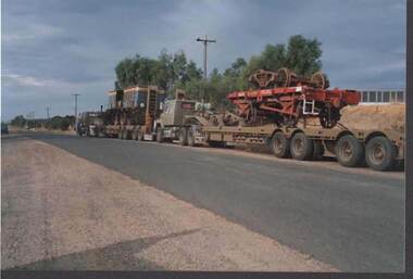
 Bendigo Historical Society Inc.
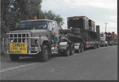
Photograph - RAILWAYS COLLECTION: A MULTI WHEEL SUPER HEAVY TRANSPORT VEHICLE
... Railways Collection - colour photo (part of a series... PHOTOGRAPH Train diesel Railways Collection - colour photo (part ...Railways Collection - colour photo (part of a series ) of an Unspecified number of Multi wheel Super Heavy Transport Vehicles-all of which appear to be transporting Railway related items. The front vehicle appears to be carrying a partly scrapped Locomotive Diesel engine there is a sign on the front vehicle - 'Danger Long wide Load' and a boy is standing on the step to the Passenger door.photograph, train, diesel -
 Southern Sherbrooke Historical Society Inc.
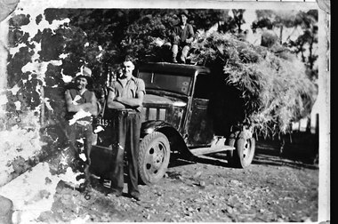
Photograph - Ernie Thorn, Bill Hermon and Jim Norton carting hay
... B&W photo (one in a series) showing l-r Ernie Thorn, Bill... photo (one in a series) showing l-r Ernie Thorn, Bill Hermon ...B&W photo (one in a series) showing l-r Ernie Thorn, Bill Hermon and Jim Norton. Ernie and Bill are standing with arms folded, in front of a Chevrolet truck, and Jim is sitting on the hay piled on the truck tray. Similar to other photos taken that day but taken from ground level. The left side of the photo has water damage. -
 Melbourne Tram Museum
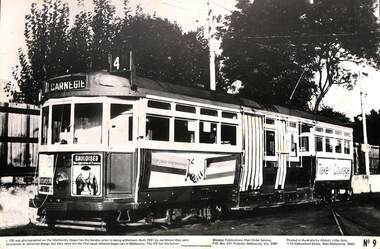
Photograph - Black and White photograph, Windsor Publications, c1975
... and Marshall batteries. Part of a series of photos by the Publisher... and Marshall batteries. Part of a series of photos by the Publisher ...Black and white photograph of - A3 size - tram L 106 (Carnegie, Route 4) at Glenhuntly Depot, undated - notes prior to the withdrawal from regular service. Photo No. 9. Tram has adverts for Gauloises cigarettes, Courage bee, Guardian Australia insure and Marshall batteries. Part of a series of photos by the Publisher. Has details of the publisher and printerHas in pencil "TMSV" in top right hand corner on rear.trams, tramways, l class, glenhuntly depot, route 4, carnegie, tram 106 -
 Charlton Golden Grains Museum Inc
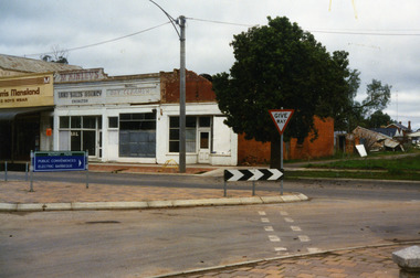
Photograph, West end Charlton High St c. 1987, c.1989
... in the 1990s. Series of photos taken for use by the Charlton Shire.... in the 1990s. Series of photos taken for use by the Charlton Shire ...Shops at the west end and on the south side of High St. Eddie Harris Mensland, and three small shops; Charles McKinley's Land Sales Agency, Hillier's Dr Cleaners and Manchester Unity. The three small shops were damaged by fire and demolished in the 1990s. Series of photos taken for use by the Charlton Shire.Colour photo of shops at the west end and on the south side of High St.Eddie Harris Mensland, Mickinley's Land Sales Agency, Hillier's Dr Cleaners and Manchester Unity. Sign on median strip pointing to Rotary Park, Public Conveniences, Electric Barbeque. Also a Give Way sign.eddie harris mensland, charles mckinley, hilliers, charlton, business, industry -
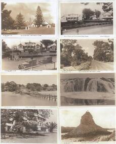 Phillip Island and District Historical Society Inc.
Photograph - postcards, Rose Series et al, Early 20th Century
... Memorial" - "Photo Shop Series Cowes from the Jetty Phillip Island..." - "Photo Shop Series Cowes from the Jetty Phillip Island" - "Isle ...One of 15 A3 sheets with copies of postcards printed on them. Shirley Jones Collection.Postcard copies: Isle of Wight Hotel, Cowes Phillip Island; Isle of Wight Hotel & War Memorial, Cowes Phillip Island; Cowes from the Jetty; Isle of Wight Hotel, Cowes Phillip Island; Isle of Wight Hotel and Souvenier Shop; Back Beach Road Cowes Phillip Island; Breaker cascades near The Nobbies; Pyramid Rock with two people on the top."The Rose Series P661 Isle of Wight Hotel Cowes Phllip Is. Vic." - "Valentine Series No. 2260 Isle of Wight Hotel + War Memorial" - "Photo Shop Series Cowes from the Jetty Phillip Island" - "Isle of Wight Hotel Cowes V14" - "Isle of Wight Hotel & Souvenier Shop Cowes Hislop Series 23" - "The Rose Series P662 Road to the Back Beach Cowes Phillip Island Vic" - "Breaker Cascades Teh Nobby Phillip Island 232" - "The Rose Series P663 The Pyramid Cowes Phillip Island Victoria".isle of wight hotel cowes phillip island, cowes war memorial, cowes from the pier, back beach road phillip island, view - breakers near nobbies, pyramid rock, shirley jones collection, thelma astbury -
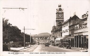 Ballarat Tramway Museum
Postcard, Rose Stereograph Co, "Sturt Street showing Town Hall, Ballarat Vic.", early 1930's
... , an earlier Rose Series photo with the same number 1712. Two copies... to item 8242, an earlier Rose Series photo with the same number ...The photo is of Sturt St showing Town Hall Ballarat Vic, looking east towards Grenville St from Doveton St. An ESCo tram is in the far distance, possibly with a Vote No sign along with a few early motor cars. In the view are Stansfield and Smith, F. Gallagher, Morseheads, Myer, The Bucks Head Hotel, and a sign for Rolfes. Note - very similar in location to item 8242, an earlier Rose Series photo with the same number 1712. Two copies held.Yields information about the appearance of Sturt St in the early 1930's, tram operations, buildings and motor vehicles.Postcard - black and white - titled The Rose Series P1712 - A divided back postcard with the rose symbol, publisher details on the left side and that it is a real photograph. trams, tramways, sturt st, doveton st, town hall, esco, rose postcards -
 Bendigo Historical Society Inc.
Photograph - RAILWAYS COLLECTION: A MULTI WHEEL SUPER HEAVY TRANSPORT VEHICLES
... Railways Collection - colour photo (part of a series... PHOTOGRAPH Train Railways Collection - colour photo (part of a series ...Railways Collection - colour photo (part of a series) of an Unspecified number of Multi wheel Super Heavy Transport Vehicles - all of which appear to be transporting Railway related items. The front vehicle appears to be carrying a partly scrapped Locomotive Diesel engine. The second vehicle is carrying a red painted four wheeled Bogie which is carrying a smaller four wheeled Bogie.photograph, train -
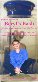 The Beechworth Burke Museum
Photograph, 02/12/2005
... This series of photos all depict Burke Museum curator Beryl...-country This series of photos all depict Burke Museum curator ...This series of photos all depict Burke Museum curator Beryl Witkowski. The invitation was created in 2005, the other photographs seem to be throughout Beryl Witkowski's career, however it is not possible to determine exactly what date they are from. The photographs show Beryl in front of the main museum building, standing beside exhibits, receiving awards and holding antiques.This series of photographs are centred around the Burke Museum curator Beryl Witkowski. The collection consists of an invitation that features mid-2000s photo editing and numerous photographs of Beryl throughout her career. The invitation provides artistic/ aesthetic significance for its interesting photo editing technique, as photo editing was becoming increasingly popular during this time. Socially, the collection of photographs are significant to the community of Beechworth and to the Burke Museum. As a curator Beryl would have had significant influence over the running and display of the museum, therefore having photographic evidence is a way for the community to reminisce and connect.Some coloured and some black and white photographs printed on paper.7599.1 Obverse: You are invited to Beryl's Bash, 'for her sins, 30 year's at the Burke' 2 December, 7pm-10pm, 2005 at Robert O'Hara Burke Memorial Museum, RSVP to Burke Museum, 03 57 28 8067 / 7599 7599.1 Reverse: and Christmas Party at the Burke Memorial Museum on 2 December, 2005 7-10pm, RSVP to the Burke by 29th November / 7599 7599.2 Obverse: Library Burke / Burke Museum / Open 10am- 5pm 7599.2 Reverse: Burke Museum / Robert O'Hara Burke Memorial [Mus]eum / Exhibitions / Notices / 1856 7599.3 Obverse: Newsagent / Est. 1853 / (illegible) invitation, christmas party, staff party, burke museum, beechworth, beryl witkowski, 2000s, employees, curator, celebration, 2000s photo editing -
 Surrey Hills Historical Society Collection
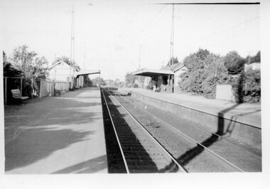
Digital photo, George L Coop, Mont Albert Railway Station c 1956, c1956
... he took this photo. It is one of a small series of photos... of a small series of photos donated by him that relate to Mont Albert ...The donor George Lister Coop was about 19 years of age when he took this photo. It is one of a small series of photos donated by him that relate to Mont Albert and Surrey Hills stations. He has always had an interest in railways and there are other examples of his documentation of railway history in other collections contributing to this database. This documents the original building on the northern platform of the Mont Albert station. The railway line was extended out to Lilydale with work commencing in 1882. It is not known exactly when the Mont Albert station was built, but it opened in 1890. It is presumed that this building was demolished when the third line was constructed in 1971. At this time the nearby Surrey Hills original station buildings were demolished.A black & white photo of Mont Albert station taken from the north platform adjacent to High Street, looking towards Box Hill. It clearly shows the bend in the line beyond the platforms. it also shows both the original buildings; the one on the north side having been demolished. There is a lady on the south platform adjacent to Hamilton Street. The roof line only of one of the Hamilton Road shops can be seen.george lister coop, mont albert station, 1956, hamilton street shops -
 Rutherglen Historical Society
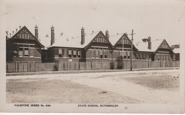
Image, Valentine Publishing Co. Ltd, State School Rutherglen, 1951
... At bottom of photo: "Valentine Series No. 986" and "State... rollason family At bottom of photo: "Valentine Series No. 986 ...Black and white postcard photograph of the front of the Rutherglen State School No. 522At bottom of photo: "Valentine Series No. 986" and "State School, Rutherglen" Written on back of card: " 'Tarrangower' | Carinish Road | Clayton Vic | 6/1/51 | Dear Mr & Mrs Lay. Just a card to with you both all the happiness and good luck for the year 1951. We have now been here about a month & just about settled down. Hope to have the pleasure of visiting you both in the near future. Trusting this will find you and the children enjoying the best of health. Kindest regards to all of you from Mrs R. and [illeg.] Yours sincerely T.F. Rollason"school buildings, rutherglen state school, lay family, rollason family -
 Bendigo Historical Society Inc.
Photograph - The Young and Wirth Families at Preston Vale, near the Springs Sedgwick, 1880s-1900s
... . The are 182 photos in this series and can be found at 8683.1... into a syphon across the gully. The are 182 photos in this series ...The Phil Wilkin Collection contains a series of 11 Items. The related items can be found by clicking on the reference link below. The following history of the Young family and their descendants who lived at the Springs is provided by Phil Wilkin. His Great Grandparents were Frances Young and August Wirth. Phil has also provided notes on the Wilkin Family and some history of the gold mining in Sedgwick. Frances Young's parents Joseph and Margaret Young owned the property called "The Old Place, Preston Vale or Wellington Flat" at Sedgwick near the Springs. Joseph Young owned and Managed the Standard Brewery which was located at Campbells Creek during the late 1800’s early 1900’s. Joseph and Margaret are buried in the Harcourt cemetery. In 1880 August Wirth lived at Mosquito Creek (Lake Eppalock, Victoria) when he married Frances Young. In 1902 they moved to part of Joseph Young's property. They milked cows and sold cattle for a living. One of their children Charles Wirth (Phil Wilkin's Grandfather) bought the land in 1935 after his parents had died. Charles Wirth was a councillor and also was president of the Shire of Strathfieldsaye. The "Old Place" was part of the property owned by members of the family. The old house at the Springs was burnt out by bushfire in January 1944 and much of the stonework was later vandalized by campers. The original Coliban Water Works were designed in 1863 by the Irish engineer Joseph Brady. The system included 70 kilometres of open water channels, aqueducts, syphons and tunnels to carry water (by gravity) from the Coliban River at Malmsbury, north to Castlemaine and Bendigo. Sedgwick is a locality in Central Victoria, Australia. It is located in the City of Greater Bendigo. Facilities include a public hall that opened in 1958 and CFA Rural fire station. It was named Upper Emu Creek until 1901 when it was renamed as Sedgwick after British geologist Adam Sedgwick.Thirty Four Photos of Joseph Young's property near "The Springs" on the main Coliban water channel from Malmsbury to the Sandhurst Reservoir in Bendigo. This item contains family history of Joeph's descendant Charles Wirth, who was a councillor for the Shire of Strathfieldsaye. The water race descends through a concrete chute, and continues sharply around the contour of the hills. Once it descended into a syphon across the gully. The are 182 photos in this series and can be found at 8683.1 to 8683.11. The series also includes photos of the surrounding farming land and the remains of an old house. There are also some notes on the pioneers of the district.history, bendigo, coliban water, joseph brady, irrigation, the springs, sedgwick, charles wirth, preston vale, joseph and margaret young, standard brewery campbells creek harcourt, phil wilkin collection