Showing 486 items
matching planning proposal
-
 Eltham District Historical Society Inc
Photograph, Russell Yeoman, Fitzsimons Lane Bridge over Yarra River between Eltham and Templestowe, c.1970, 1970c
The bridge over the Yarra River was initially opened September 22nd, 1961. Newspaper reports at the time of opening stated it linked Bolton Street, Eltham, with Fitzsimons Lane, Templestowe. In 1955 the Country Roads Board (CRB) produced survey plans that showed proposed land acquisition for the future bridge and road approaches. The 1955 plan shows that it was proposed to connect Fitzsimons Lane with Bolton Street in Eltham by a diagonal road across the river. The road connection would then continue along Bolton Street to Main Road. Prior to construction of the bridge the CRB modified the proposal significantly so that there was a new road parallel with Bolton Street and then curving to join Main Road at what was then its intersection with Old Eltham Road. This involved significantly more land acquisition and altered the pattern of land subdivision through this corridor. Initially the new road was just a single two-way carriageway as it would have required a significant widening of the cutting on the Shire of Eltham side of the river. The road was officially un-named but was known locally as the Eltham-Templestowe Road. The 1966 Melway street directory and other 1960s editions also listed the road as the Eltham-Templestowe Road. In December 1970, Eltham Shire Council, in pursuance of the provisions of the Local Government Act, named it Templestowe Road. The road was renamed Fitzsimons Lane around 1984 in conformity with the section south of the river. In 1991 a new bridge was built to the west of the original bridge. Fitzsimons Lane was widened to four traffic lanes although on the Eltham side this was done within the limits of the existing cutting. NEW BRIDGE STARTS THEM EXPLORING Without any fanfares, Country Roads Board workmen on Friday afternoon put the finishing touches to the approaches, removed the barricades, and let the traffic roll over the new Yarra bridge linking Bolton Street, Eltham, with Fitzsimons Lane, Templestowe. Over the week-end many “bridge watchers” who were making one of their periodic inspections of the progress on the new bridge found to their surprise that they could drive over it, so that people who had gone for a run out to Eltham suddenly found themselves wandering through Templestowe and Doncaster. By Monday the word of the bridge’s opening had got around sufficiently for many regular travellers to the city from Eltham and beyond to vary the monotony by going to town via Templestowe and Kew instead of through Heidelberg. They were surprised at the distances – about 3 ½ miles from Eltham to Templestowe, 6 miles from Eltham Shire hall to the Lower Heidelberg Road-Banksia Street intersection. NEW NEIGHBOURS For people on both sides of the river, the new bridge has turned distant friends into near neighbours. A Greensborough man on Sunday took 35 minutes to reach the home of a friend in East Doncaster, but the return trip over the new bridge took only 17 minutes. It will be some time yet before most people work out the possibilities in shorter and quicker trips form the north-eastern areas to the eastern and south-eastern suburbs. The coming of the warmer months will soon teach many, though the short cuts to Peninsular beaches and eastern suburban drive-ins. And before very long it is likely there will be a Tramways bus running from Templestowe to Eltham station. NEW BRIDGE STARTS THEM EXPLORING (1961, September 27). The Diamond Valley News (News clipping held in SEA_74-1_047) The previously un-named road between Main Road and Yarra River, Eltham South, east of Bolton Street was named Templestowe Road, December 15, 1970 NAMING OF STREETS AND ROADS. (1970, December 15). The Diamond Valley News (News clipping held in SEA_74-2_022)Roll of 35mm black and white negative film, 4 of 7 stripsIlford HP4bridge, bridges, fitzsimons lane bridge, infrastructure, shire of eltham infrastructure, yarra river -
 Eltham District Historical Society Inc
Photograph, Fitzsimons Lane Bridge over Yarra River between Eltham and Templestowe, c.1966, 1966c
The bridge over the Yarra River was initially opened September 22nd, 1961. Newspaper reports at the time of opening stated it linked Bolton Street, Eltham, with Fitzsimons Lane, Templestowe. In 1955 the Country Roads Board (CRB) produced survey plans that showed proposed land acquisition for the future bridge and road approaches. The 1955 plan shows that it was proposed to connect Fitzsimons Lane with Bolton Street in Eltham by a diagonal road across the river. The road connection would then continue along Bolton Street to Main Road. Prior to construction of the bridge the CRB modified the proposal significantly so that there was a new road parallel with Bolton Street and then curving to join Main Road at what was then its intersection with Old Eltham Road. This involved significantly more land acquisition and altered the pattern of land subdivision through this corridor. Initially the new road was just a single two-way carriageway as it would have required a significant widening of the cutting on the Shire of Eltham side of the river. The road was officially un-named but was known locally as the Eltham-Templestowe Road. The 1966 Melway street directory and other 1960s editions also listed the road as the Eltham-Templestowe Road. In December 1970, Eltham Shire Council, in pursuance of the provisions of the Local Government Act, named it Templestowe Road. The road was renamed Fitzsimons Lane around 1984 in conformity with the section south of the river. In 1991 a new bridge was built to the west of the original bridge. Fitzsimons Lane was widened to four traffic lanes although on the Eltham side this was done within the limits of the existing cutting. NEW BRIDGE STARTS THEM EXPLORING Without any fanfares, Country Roads Board workmen on Friday afternoon put the finishing touches to the approaches, removed the barricades, and let the traffic roll over the new Yarra bridge linking Bolton Street, Eltham, with Fitzsimons Lane, Templestowe. Over the week-end many “bridge watchers” who were making one of their periodic inspections of the progress on the new bridge found to their surprise that they could drive over it, so that people who had gone for a run out to Eltham suddenly found themselves wandering through Templestowe and Doncaster. By Monday the word of the bridge’s opening had got around sufficiently for many regular travellers to the city from Eltham and beyond to vary the monotony by going to town via Templestowe and Kew instead of through Heidelberg. They were surprised at the distances – about 3 ½ miles from Eltham to Templestowe, 6 miles from Eltham Shire hall to the Lower Heidelberg Road-Banksia Street intersection. NEW NEIGHBOURS For people on both sides of the river, the new bridge has turned distant friends into near neighbours. A Greensborough man on Sunday took 35 minutes to reach the home of a friend in East Doncaster, but the return trip over the new bridge took only 17 minutes. It will be some time yet before most people work out the possibilities in shorter and quicker trips form the north-eastern areas to the eastern and south-eastern suburbs. The coming of the warmer months will soon teach many, though the short cuts to Peninsular beaches and eastern suburban drive-ins. And before very long it is likely there will be a Tramways bus running from Templestowe to Eltham station. NEW BRIDGE STARTS THEM EXPLORING (1961, September 27). The Diamond Valley News (News clipping held in SEA_74-1_047) The previously un-named road between Main Road and Yarra River, Eltham South, east of Bolton Street was named Templestowe Road, December 15, 1970 NAMING OF STREETS AND ROADS. (1970, December 15). The Diamond Valley News (News clipping held in SEA_74-2_022)Black and white photographManufacturer's marks: Polaroid, Batch #J62K181 (Sep 1966).infrastructure, shire of eltham infrastructure, bridge, fitzsimons lane bridge, polaroid, yarra river -
 Eltham District Historical Society Inc
Photograph, Fitzsimons Lane Bridge over Yarra River between Eltham and Templestowe
The bridge over the Yarra River was initially opened September 22nd, 1961. Newspaper reports at the time of opening stated it linked Bolton Street, Eltham, with Fitzsimons Lane, Templestowe. In 1955 the Country Roads Board (CRB) produced survey plans that showed proposed land acquisition for the future bridge and road approaches. The 1955 plan shows that it was proposed to connect Fitzsimons Lane with Bolton Street in Eltham by a diagonal road across the river. The road connection would then continue along Bolton Street to Main Road. Prior to construction of the bridge the CRB modified the proposal significantly so that there was a new road parallel with Bolton Street and then curving to join Main Road at what was then its intersection with Old Eltham Road. This involved significantly more land acquisition and altered the pattern of land subdivision through this corridor. Initially the new road was just a single two-way carriageway as it would have required a significant widening of the cutting on the Shire of Eltham side of the river. The road was officially un-named but was known locally as the Eltham-Templestowe Road. The 1966 Melway street directory and other 1960s editions also listed the road as the Eltham-Templestowe Road. In December 1970, Eltham Shire Council, in pursuance of the provisions of the Local Government Act, named it Templestowe Road. The road was renamed Fitzsimons Lane around 1984 in conformity with the section south of the river. In 1991 a new bridge was built to the west of the original bridge. Fitzsimons Lane was widened to four traffic lanes although on the Eltham side this was done within the limits of the existing cutting. NEW BRIDGE STARTS THEM EXPLORING Without any fanfares, Country Roads Board workmen on Friday afternoon put the finishing touches to the approaches, removed the barricades, and let the traffic roll over the new Yarra bridge linking Bolton Street, Eltham, with Fitzsimons Lane, Templestowe. Over the week-end many “bridge watchers” who were making one of their periodic inspections of the progress on the new bridge found to their surprise that they could drive over it, so that people who had gone for a run out to Eltham suddenly found themselves wandering through Templestowe and Doncaster. By Monday the word of the bridge’s opening had got around sufficiently for many regular travellers to the city from Eltham and beyond to vary the monotony by going to town via Templestowe and Kew instead of through Heidelberg. They were surprised at the distances – about 3 ½ miles from Eltham to Templestowe, 6 miles from Eltham Shire hall to the Lower Heidelberg Road-Banksia Street intersection. NEW NEIGHBOURS For people on both sides of the river, the new bridge has turned distant friends into near neighbours. A Greensborough man on Sunday took 35 minutes to reach the home of a friend in East Doncaster, but the return trip over the new bridge took only 17 minutes. It will be some time yet before most people work out the possibilities in shorter and quicker trips form the north-eastern areas to the eastern and south-eastern suburbs. The coming of the warmer months will soon teach many, though the short cuts to Peninsular beaches and eastern suburban drive-ins. And before very long it is likely there will be a Tramways bus running from Templestowe to Eltham station. NEW BRIDGE STARTS THEM EXPLORING (1961, September 27). The Diamond Valley News (News clipping held in SEA_74-1_047) The previously un-named road between Main Road and Yarra River, Eltham South, east of Bolton Street was named Templestowe Road, December 15, 1970 NAMING OF STREETS AND ROADS. (1970, December 15). The Diamond Valley News (News clipping held in SEA_74-2_022)Black and white photographinfrastructure, shire of eltham infrastructure, bridge, fitzsimons lane bridge, yarra river -
 Port Melbourne Historical & Preservation Society
Book, Kate Shaw et al, Bayside Views - a collection of critical perspectives on the Bayside development, Feb 1988
... and the Victorian Parliament resumed sittings. Town Planning - Proposals ...This book was compiled by Kate SHAW of St Kilda, one who had battled against the SCDC 'Bayside' development and the demolition of the Missions to Seamen building, by asking a number of academics and community members to write essays on various aspects of the development. The book was launched at the MIssions to Seamen building in February 1988, as both the Environmental Effects Enquiry and the Victorian Parliament resumed sittings.Paper back book, 76 pages, white cover printed in blue and black, titled 'Bayside Views - a collection of critical perspectives on the Bayside development'town planning - proposals shelved - bayside, environmental issues, kate shaw, judy wilks, pat grainger, kim dovey, barbara riddoch-mouy, maggie fooke, kirk hanscombe, mike berry, chris ryan, bob mcdonald, cura, peter justice, mark bartley, vicki davies -
Port Melbourne Historical & Preservation Society
Document - Newsletter, Issue 2, Bayside Bulletin, 1987
... Town Planning - Proposals Shelved - Bayside Local ...Bayside Bulletin, a set of newsletters issued by the City of Port Melbourne to keep residents informed about the Bayside development: second in a series of community bulletins (no date)town planning - proposals shelved - bayside, local government - city of port melbourne, environmental issues, sandridge city development co pty ltd, scdc, evan walker, perce mcguire white, perce white -
Port Melbourne Historical & Preservation Society
Document - Newsletter, Issue 5, Bayside Bulletin, 1988
... Town Planning - Proposals Shelved - Bayside Evan WALKER ...Bayside Bulletin, a set of newsletters issued by the City of Port Melbourne to keep residents informed about the Bayside development: Issue 5 (no date)town planning - proposals shelved - bayside, evan walker, golder associates, dames and moore, perce mcguire white, perce white -
Port Melbourne Historical & Preservation Society
Document - Newsletter, Issue 4, Bayside Bulletin, 1987
... Town Planning - Proposals Shelved - Bayside Evan WALKER ...Bayside Bulletin, a set of newsletters issued by the City of Port Melbourne to keep residents informed about the Bayside development: Issue 4 (no date)town planning - proposals shelved - bayside, evan walker, perce mcguire white, perce white -
Port Melbourne Historical & Preservation Society
Document - Newsletter, Special Issue, Why an alternative, Bayside Bulletin, 1987
... Town Planning - Proposals Shelved - Bayside Local ...Bayside Bulletin, a set of newsletters issued by the City of Port Melbourne to keep residents informed about the Bayside development: special issue 'Why an alternative' (no date)town planning - proposals shelved - bayside, local government - city of port melbourne, environmental issues, sandridge city development co pty ltd, scdc, evan walker, perce mcguire white, perce white -
Port Melbourne Historical & Preservation Society
Document - Newsletter, Issue 3, Bayside Bulletin, 1987
... town planning - proposals shelved - bayside Bayside ...Bayside Bulletin, a set of newsletters issued by the City of Port Melbourne to keep residents informed about the Bayside development: third in a series of community bulletins (no date)town planning - proposals shelved - bayside -
Port Melbourne Historical & Preservation Society
Document - Newsletter, Issue 7, Bayside Bulletin, 1989
... Town Planning - Proposals Shelved - Bayside Wendy MORRIS ...Bayside Bulletin, a set of newsletters issued by the City of Port Melbourne to keep residents informed about the Bayside development: Issue 7, June 1989town planning - proposals shelved - bayside, wendy morris, josef (jo) szwarc -
Port Melbourne Historical & Preservation Society
Document - Newsletter, Issue 6, Bayside Bulletin, 1989
... town planning - proposals shelved - bayside evan walker ...Bayside Bulletin, a set of newsletters issued by the City of Port Melbourne to keep residents informed about the Bayside development: Issue 6, April 1989town planning - proposals shelved - bayside, evan walker -
Port Melbourne Historical & Preservation Society
Document - Newsletter, Issue 8, Bayside Bulletin, 1989
... town planning - proposals shelved - bayside Bayside ...Bayside Bulletin, a set of newsletters issued by the City of Port Melbourne to keep residents informed about the Bayside development: Issue 8, August 1989town planning - proposals shelved - bayside -
Port Melbourne Historical & Preservation Society
Document - Newsletter, Issue 10, Bayside Bulletin, 1990
... Town Planning - Proposals Shelved - Bayside Josef (Jo ...Bayside Bulletin, a set of newsletters issued by the City of Port Melbourne to keep residents informed about the Bayside development: Issue 10, May 1990town planning - proposals shelved - bayside, josef (jo) szwarc, robert peck, evan walker -
Port Melbourne Historical & Preservation Society
Document - Newsletter, Issue 9, Bayside Bulletin, 1989
... Town Planning - Proposals Shelved - Bayside Josef (Jo ...Bayside Bulletin, a set of newsletters issued by the City of Port Melbourne to keep residents informed about the Bayside development: Issue 9, December 1989town planning - proposals shelved - bayside, josef (jo) szwarc -
Port Melbourne Historical & Preservation Society
Document - Newsletter, Special Issue, Why Port refused the State Government's "final offer"on Bayside, Bayside Bulletin, Mar 1989
... town planning - proposals shelved - bayside chris raeburn ...Bayside Bulletin, a set of newsletters issued by the City of Port Melbourne to keep residents informed about the Bayside development: Special issue 'Why Port refused the State Government's "final offer"on Bayside' (no date) 4pptown planning - proposals shelved - bayside, chris raeburn, jim kennan -
Port Melbourne Historical & Preservation Society
Document - Newsletter, A better alternative, Bayside Bulletin, 1991
... town planning - proposals shelved - bayside chris raeburn ...Bayside Bulletin, a set of newsletters issued by the City of Port Melbourne to keep residents informed about the Bayside development: A better alternative (no date)town planning - proposals shelved - bayside, chris raeburn, jim kennan -
University of Melbourne, Burnley Campus Archives
Plan, Albert Park, c.1994
Plans of sections of Albert Park by The Hassell Group, Lead Consultant Land Systems EBC, Melbourne Parks & Waterways. 1 copy laminated of each of: (1) 2 copies Albert Park Golf Course Proposal. (2) Ross Gregory Drive Precinct. (3) Lakeside Drive May 1994. (4) 2 copies New South Melbourne Soccer Ground. (5) 2 copies Aughtie Drive. (6) 2 copies Aughtie Drive Precinct. (7) 2 copies New Home for South Melbourne Cricket Club. (8) Final Proposed Strategy Plan: Realising the Vision, coloured, Key features of the plan on reverse. -
 Eltham District Historical Society Inc
Audio - Audio Recording, Audio Recording; 2018-10-13 Eltham Community Town Hall Meeting, 13 Oct 2018
Meeting to discuss the Nillumbik Shire Council's proposed sale and devlopment of the former Shire Office site at 895 Main Road as well as the Eltham War Memorial including the Maternal and Infant Welfare Centre, Eltham Pre-school and Eltham War Memorial Hall and Memorial Gardens at 903-907 Main Road which also includes thje Eltham Senior Citizen's Centre. The meeting was attended by more than 300 people which considered the following: Motion from public meeting – Saturday 13th October, 2018 1. This meeting has no confidence in Nillumbik Shire Council's proposed process for the re-development of 895 and 903-907 Main Rd, Eltham and we deplore the cursory attention given to public consultation to date. 2. We call on Council: *to preserve the Eltham War Memorial building complex at 903-907 Main Rd, Eltham, and retain their existing uses in accordance with the Eltham War Memorial Trust purpose; and retain the Cenotaph and Eltham Senior Citizens' Centre. * to retain council ownership of all land at 895 and 903-907 Main Rd, Eltham for our community and future generations. * following meaningful engagement with residents of the Shire, to place sufficient planning controls on the site of the former Eltham Shire Office to ensure that any future development of that land responds to Eltham's form and character and properly protects public amenity, access and use. * to make all proposals for the development of 895 and 903-907 Main Rd, Eltham available for public inspection as soon as they are received by Council. Moved: Greg Johnson Seconder: Andrew Lemon * carried unanimously1:28:52 duration Digital MP3 File 30.5 MB 895 main road, 903-907 main road, community meeting, eltham pre-school, eltham shire office, eltham war memorial, eltham war memorial hall, infant welfare centre, nillumbik shire council, senior citizen's centre -
 Eltham District Historical Society Inc
Audio - Audio Compact Cassette Tape, Harry Gilham, Audio Recording; Eltham Library History presented by Harry Gilham, 1994
The new Eltham Library was opened 22 May 1994 and celebrates its 30th anniversay in 2024. This audio recording, presented by Harry Gilham, President of Eltham District Historical Society at the time of the opening is a summarised history of the Eltham Library service to 1994. Eltham Library Service 1930s - 1994 Originally collated by Harry Gilham, President, Eltham District Historical Society Inc (1993-2009) (edited 2022) In the Eltham township area, in the early 1930s, library books for adults were available from E J Andrew's newsagency in Main Road. In the newsagency come haberdashery, some shelves were set aside for a lending library of adults' books. In 1935, Mr & Mrs JC Rains purchased the newsagency and continued the lending service until the late 1940s. At this time the business was extended from haberdashery to sell ladies' and men's clothing. The library section was discontinued. In the 1930s a mobile book library was also run by a Mr Foster of Bible Street, Eltham. In the 1950s adult books were available from racks in the foyer of the Eltham Shire Offices which was then located beside the Eltham Hall on the comer of Arthur Street and Main Road. In the early 1950s a referendum of ratepayers was called to seek public opinion on the issue of raising money for a public library for which the rates would have to be increased - the motion was defeated. On 11 November 1965 Eltham Shire Council, in conjunction with the City of Heidelberg and the Shire of Diamond Valley, met to form the Heidelberg Regional Library Service. Eltham was represented by Councillors Charis Pelling and John Lewis. The first library service for the Shire of Eltham from this group came in the shape of a bookmobile van which had, amongst others, a central stopover near the Shillinglaw trees outside the newly opened Shire offices at 895 Main Road, the original site of Shillinglaw Cottage and the former Shillinglaw farm. Present-day Wingrove Park was another stopover and the many recorded requests for this service can be read as denoting the areas of population or gathering points at that period throughout the Shire. 1968 saw the Shire convert the ‘Brinkkotter’ house in Dudley Street to house both adult and children's books. This library was originally staffed from the City of Heidelberg Library and records of committee meetings range from borrowing Heidelberg's old library shelving to trying to increase the Government's subsidy to a dollar for dollar basis. Book loans in the period 1966-67 totalled 30,400 and the following year ran to 52,113. With 2 books plus 1 paperback the limit per person, it was overcrowded and unable to house the range of other services which had become common library stock. Planning to extend the Shire Offices by the addition of the south wing was an opportunity to re-house the Shire's Library. The opening of the library in the extension was carried out on 17th August 1971 by the Hon R J Hamer ED, MP, Chief Secretary of Victoria. Cr Geoffrey Dreverman officiated as the Shire President. The Heidelberg Regional Library Service continued until September 1985 when it disbanded. On 21 November 1985 the Yarra Plenty Regional Library Service was established. At that time Eltham was represented by Councillors Mary Grant and Robert Manuell. By 1987, over-crowding of the Eltham Library and an inability to house the range of other services yet again rose to prominence. At a Council meeting held on 1 June 1987, the Councillors supported a resolution which threatened to close the library on 30 September 1987. Council's frustration arose from yet another re-run of the annual State Government versus Council Library funding and records show first arose in Eltham Council in 1967 with the Government of 1he day. After prolonged public anger and petitions the motion to close the library was rescinded in August 1987. Council, considering the community's concern, set up a ‘Library Review Working Party’ which a year later became the Library Occasional Committee with direct access to Council. This Committee investigated the workings of the 386 square metre library and found inadequate space for storage and display, lack of equipment, out-of-date furniture together with an increasing patronage which resulted in queues of borrowers becoming longer no matter when the library was open. Community consultation took the form of 1,000 questionnaires sent to users and non-users along with noticeboard reminders of what was planned. Council developed a strategy to set aside capital funds from 1988 on an annual basis so that preliminary planning and consultative expenses could be met, and construction could be completed early 1997. The Committee visited metropolitan libraries which were catering for a similar population as was projected for Eltham. Australia-wide Federal Government funding grants under the Local Capital Works Program became available from October 1992 for community projects endorsed by local Councils. The Eltham Council submitted a proposal, based on library findings and requirements accumulated by the Library Occasional Committee, to the Federal Grants Committee to build a new Eltham Library. The Federal Grants Committee supported the funding request allowing commencement of the library project three years earlier than planned. With finance finalised, the Council set up its Eltham Library Re-development Special Committee which was given the task of overseeing what could be the last major expansion of the Shire's Library Service as Eltham's population nears its projected maximum. The new library was designed by Gregory Burgess and Peter Ryan of Gregory Burgess Pty Ltd. Construction of the library commenced in 1993 and was officially opened May 22nd, 1994. The library building was designed to reflect its parkland setting. External features include: the roof which includes interesting aspects when viewed from Main Road; verandahs which provide ramp access and give a sheltered entrance to the building; walls which feature locally made mudbricks, conventional bricks and copper panels; and space for an outdoor courtyard/reading area which will be developed later. Internally there are several features. The building includes a foyer with a fireplace suitable for displays including artwork, a community multi-purpose room suitable for meetings or functions and an outdoor cafeteria. The ceilings are lined with Victorian Ash. The shapes for the ceiling give a free-flowing form to the building. Brush Box has been used for the circulation and information desks. The tree trunk columns are Grey lronbark from New South Wales. Arches and various-shaped windows add interest to the internal structure. The carpet design reflects the Eltham environment and compliments the natural colours and timbers used in the building. Tiles by artist Felix Bosari feature in the building and additional art by local artists added externally and internally to the building. Since 1994 the library has undergone a major extension to cater for children’s services and others. See also EDHS_02111Digital file only recorded from Audio Cassette tape on loan Converted to MP3 file; 11.1MB, 0:08:49eltham library, opening, harry gilham, harry gilham collection, 1994, audio cassette, audio recording -
 University of Melbourne, Burnley Campus Archives
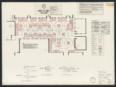
Plan, Steve Mullany, Classroom Quadrangle/Library Courtyard, 1985-1999
Various plans. (1) Photocopy of Section A-A, 1985 and 1 photocopy of part of plan. (2) Tracing paper copy, Construction Plan Classroom/Library Quadrangle Feb. 1986. (3) Master Plan, coloured and detailed and 1 copy not detailed, Classroom Quadrangle Landscape Redevelopment by S. Mullany, 10 August 1988. (4) 4 tracing paper and 2 paper copies Set of Plans Library Courtyard Aug 1992 by KW. (5) Miscellaneous sketches. (6) Assessment task. (7) Sketch Proposal Quad Entry by M. Green May 1995. (8) Quadrangle Steps Redevelopment 7/12/99 by Phil Tulk. (9) Tracing paper and paper copies Quadrangle Steps Redevelopment by JK 20.12.99.classroom, library, courtyard, steve mullany, quadrangle, landscape design, steps -
 University of Melbourne, Burnley Campus Archives
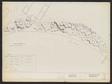
Plan, Entrance Proposal, 1987-1988
... 28.9.88 by JK. Entrance Proposal Plan ...Plans for Entrance from Yarra Boulevard. (1) Tracing paper and paper copies, Entrance Proposal Drawing No. 1. V.C.A.H. Burnley, Aug '87 by R.C., Planting Plan. (2) Tracing paper and paper copies V.C.A.H. Burnley 28.9.88 by JK.vcah, burnley, main entrance, jill kellow -
 University of Melbourne, Burnley Campus Archives
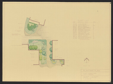
Plan, Student Amenity Building (Citriodora) Courtyard, 1988-2000
Various plans for what is now known as the "Citriodora Courtyard." I copy tracing paper, 1 coloured original, 4 copies with additional notation 6 smaller copies with additional notation. (1) Planting Plan Plant Science Area V.C.A.H. Burnley designed by J. Hitchmough, drawn by S. Mullany 3 October 1988. (2) Student Amenity Quad Sketch Proposal by M. Green May '95. (3) Rough pencil design, New Design related to Horticultural pursuits of Burnley College. (4) Coloured, Proposed Citriodora Court Redevelopment. (5) 2 copies Citriodora Courtyard Presentation Concept Plan by Adrian Bonifacio. November 2000. (6) Landscape Graphics II Assoc. Diploma in Horticulture (Amenity) Assignment 2 - Planting Plan May 1988. (7) Laminated, Preliminary Plan 2 of 4 Citriodora Lawn Burnley by Kate Szmal B.A.S.H. (8) Laminated, Preliminary Plan Student Amenity Building Courtyard V.C.A.H. Burnley by Caroline Lodge. (9) 1 tracing paper and 1 paper copy University of Melbourne Burnley College Student Amenity Building Courtyard 19.8.99. (10) Setout Plan, Planting Plan & Surface Finishes, Details Courtyard & Entrance, ACM Landscape Architecture: Concrete Paving Topsoil, Mulch - notes. "Phil Tulk," handwritten on reverse. (11) Laminated, V.C.A.H. Preliminary Plan p3 of 5 Project No 1 Student Amenity Building Courtyard by K. Watson 15-8-95. (12) Citriodora Courtyard Redevelopment Concept Plan by Judy Brookes November 2000. 2 copies of Drawing 1 of 2, 1 copy Drawing 2 of 2. (13) Proposed Outdoor Eating Area Student Amenities Block: Scheme 1 pp 2-5 of 5, 16.10.96. Scheme 2 pp 3-5 of 5, 16.10.96. Scheme 8 3 copies p1 of 2, 2 copies p2 of 2, 23.6.97, Paving Types p1 of 1, 30.9.99, handwritten on reverse,"to Phil from Nicki." (14) 2 copies Entry from Rear Car Park Paving Plan. (15) Plan by Margaret Kitching 8.8.90. citriodora courtyard, vcah, centenary courtyard, plant science area, k. watson, s. mullaney, j. hitchmough, judy brookes, kate szmal -
 Port Melbourne Historical & Preservation Society
Archive, 1970s and 1980s
Various typescripts, publications, card indexes, etc. compiled by Nancy U'Ren relating to her 1976 MA thesis "Early Growth and Development of Sandridge" and her contribution to the 1983 book "A History of Port Melbourne"city of port melbourne, metropolitan town planning commission, port melbourne gateway proposal 1999, garden city, electoral rolls, marriage and baptism records, victorian legislative council, censuses -
Bendigo Historical Society Inc.
Document - Regional Forum Report for CoB by RASMAC, Michele Matthews Collection, 8.6.1999
The Sir John Quick Committee was formed in 1991 to commemorate the achievements of Sir John Quick who played a prominent role in the federation of Australia. The Committee aimed to raise awareness of the contribution of Sir John Quick and to ensure that he was recognized for the part he played.Nine page report for the City of Bendigo dated 8.6.1999 issued by Jenny Whitelaw, Senior Advisor. The report covers the content and recommendations following a regional forum and workshop sessions conducted through the Regional and Specialist Museums Advisory Committee (RASMAC) Leadership program, held on May 24 and 25 1999. "The purpose of this forum was to identify the major issues for consideration in planning a museum concept for Bendigo." Includes List of attendees. Issues of importance and recommendations to the City of Greater bendigo. Suggested themes for Bendigo Museum of Victoria. Recommendations for consideration with regard to: City of Greater Bendigo proposal to establish a museum.sir john quick committee, bendigo museum of victoria, rasmac, regional and specialist museums advisory committee, jenny whitelaw -
University of Melbourne, Burnley Campus Archives
Plan, Phil Tulk, Building 9 and Surrounds Landscape Proposal, 1999
... and Surrounds Landscape Proposal Plan Phil Tulk ...Coloured plan by P. Tulk for AMRAD Corporation 13/8/99phil tulk, buildings, amrad corporation, landscape design -
Port Melbourne Historical & Preservation Society
Book, Kate Shaw et al, Ewan Ogilvy's Bayside Papers, Box Three - Bayside Views - A Collection of critical perspectives on the Bayside Development, 1988
... town planning - proposals shelved - bayside public action ...Ewan OGILVY, former Melbourne Councillor and also of Community Services Victoria, Inner Urban Ministerial Advisory Committee and Uniting Church's Centre for Urban Research and Action (CURA), was instrumental in social justice approaches to town planning. He and CURA's Social Justice and the City Project funded Port Melbourne community groups protesting against the SCDC development in 1987. His files were presented to the Society in May 2001 on his preparation for leaving Victoria.From Ewan OGILVY'S chronologically organised 'Bayside Papers' relating to the proposed development of Port Melbourne industrial land in the late 1980s: Bayside Views - A Collection of critical perspectives on the Bayside Development, a book of essays on Bayside issues, 1988 - funded by the Justice in the City projectSigned 'Ewan Ogilvy'town planning, town planning - proposals shelved - bayside, public action campaigns, environmental issues, public housing, missions to seamen, centre for urban research and action (cura), uniting church, sandridge city development co pty ltd, scdc, linton r lethlean, barry pullen, ewan ogilvy