Showing 14627 items
matching printed photographs
-
 The Beechworth Burke Museum
Photograph, 2000
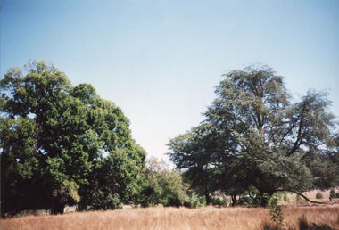
... A colour rectangular photograph printed on glossy... A colour rectangular photograph printed on glossy photographic ...Woolshed is a small area about five kilometres north west of Beechworth, and almost about 225km north east of Melbourne. When gold was discovered at the nearby Spring Creek in February 1852, Woolshed was one of three settlements set up to house miners and their families. At its peak in 1857, Woolshed was also populated by 29 storekeepers and 14 hotels, as well as the Woolshed State School, which stood near where this photograph was taken. The school often played host to public meetings, as well as a public dance in 1897. The school was subject to some controversy in 1874 when one parent complained about the head of the school in the local newspaper, the Owens and Murray Advertiser, and at least three letters to the editor were exchanged between the two. According to the parent, C. O'Donoghue was not providing enough amusement for the children and was disrespectful to parents and staff. When the State Governor, Sir Reginald Talbot, visited Beechworth in 1906, the school organised a celebratory welcome. The Woolshed State School was ultimately closed in 1922 as miners had exhausted the Spring Creek gold supply and were moving elsewhere. This photograph, taken in about 2000, shows the trees that grew on or near the site of the original school. The Woolshed State School Honour Roll, with a list of the men from the school who served in the First World War, also still exists. It is stored in the Beechworth RSL as of 2015.This photograph is significant for its connection to an important site in Beechworth's gold mining history. Woolshed served a significant community of miners, with a population of at least 138 according to the 1911 census, with families that needed the school site to ensure their children's education. The image is also useful for prompting discussion about how Beechworth has changed over time, with the photograph taken 78 years after the school closed down.A colour rectangular photograph printed on glossy photographic paper.Woolshed State. / School site / 2000 / - remnant trees / / cobeechworth, burke museum, school, education, trees, nature, state school, woolshed, gold mining, teachers, over time, owens and murray advertiser, public meetings, public dance, c. o'donoghue, spring creek, state governor, sir reginald talbot, miners, honour roll, world war 1 -
 The Beechworth Burke Museum
Photograph, c.1927-1930
... Sepia rectangular photograph printed on matte photographic... photograph printed on matte photographic paper Photograph Photograph ...This image shows the Punt (a kind of small boat) that took residents of Bethanga across the Murray River before the Bethanga Bridge was built. Bethanga Bridge was built between 1927 and 1930, and was made a necessity by the building of the Hume Dam. The Hume Dam, formerly known as the Hume Weir, was in construction between 1919 and 1936, which swelled the Murray River into the floodplain to the East of the dam permanently, creating Lake Hume, and isolating the residents of Bethanga and nearby towns, for whom the trip all the way around the new lake to another river crossing was a massive undertaking. The person who wrote on the back of this card instead chose to cross the river on a boat until the Bethanga Bridge became available. Interestingly, partially submerged trees can be seen in the lake in the background of this photograph, illustrating that the dam had already begun to fill the floodplain even before the bridge was built. This photograph shows the methods the residents of Bethanga used while the Bethanga Bridge was being built. This record is associated with the Heritage Listed sites of the Hume Dam and the Bethanga Bridge, and shows the environment during the process of construction and the creation of Lake HumeSepia rectangular photograph printed on matte photographic paperReverse: 1997.3189 / 84 -19 -1 / This is the snap of the Punt. / Our only means of getting out / of Bethanga for the present / Until the bridge is completed / it is 2 miles above the junction / of the Mitta + Murray. It is / 1/2 a mile wide + runs across / the Murray into NSW / Kodak Print / bethanga, bethanga bridge, hume, hume dam, artificial lake, lake hume, hume weir, flood, floodplain, boat, punt, weir, pier, dock, transport, transportation -
 The Beechworth Burke Museum
Photograph - Photograph - Reproduction
... Black and white rectangular reproduced photograph printed... photograph printed on paper Photograph Photograph - Reproduction ...The photograph is a reproduction of a postcard from the Rocky Mountain Mining Company. In 1875, the Rocky Mountain Extended Gold Sluicing Company Ltd was created, utilising the previous Rocky Mountain claim for the area near Lake Sambell. The company employed A.L Martin to survey an area for a tunnel underneath Beechworth and Johnson Stephens to dig it. The tunnel was built at a rate of 40 feet a month and eventually measured 800 metres. The tunnel was a true accomplishment both in the present and during the 19th century. It was considered to be a marvelous engineering feat. Beechworth is renowned for its hydraulic sluice method of mining. This involved soil being exposed to torrents of water from high-pressure hoses. From 1876 until its closure in 1921, the mine produced an astounding 47,926 ozs of gold. Companies like this were the source of income for many Chinese gold-diggers who sought to make their fortune on the goldfields of Beechworth. During the height of the rush, the town had around 7,000 Chinese inhabitants living on the outskirts of town as they were not permitted to live within Beechworth itself.This image of the Rocky Mountain mine is historically significant as the mining complex is now non-existent, with the only remains being the tunnel built in 1880 by the company, which was considered one of the greatest engineering feats of the time. The image also provides a first-hand look into the social and cultural networks at play during the 19th century with racial segregation of the Chinese at the 'Chinese Camp', as well as an insight into Beechworth's origins during the Gold Rush.Black and white rectangular reproduced photograph printed on paperbeechworth, rocky mountain mine, sluicing, gold rush, mining, gold -
 The Beechworth Burke Museum
Photograph - Photograph - Reproduction, c1965
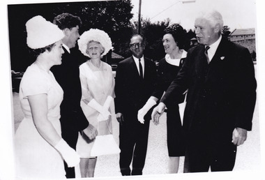
... A black and white rectangular reproduction photograph... and white rectangular reproduction photograph printed on paper ...This photograph depicts the visit of Sir Rohan Delacombe and Lady Delacombe (on right) to Beechworth in 1965. Also present are Shire Secretary Graham Gray and Mrs Gray (left), and Shire President J McCauley and Mrs McCauley, centre. His Excellency Sir Rohan Delacombe (1906–1991) was appointed Governor of Victoria on 8 May 1963 and served until 1974, when he was replaced by the first Australian-born governor, Sir Henry Winneke. Born on 25 October 1906 at St Julians, Malta, Sir Rohan was the second child and only son of Addis Delacombe, a British army pay officer, and his wife Emma Louise Mary, née Leland. The Delacombe family seat was Shrewton Manor, near Salisbury, Wiltshire, and several generations of Delacombes had served in the armed forces. Sir Rohan took up his role in Australia following long and distinguished military and diplomatic career. He is reported to have taken great interest in local events and politics, and at the time this image was taken, he and Lady Delacombe made several appearances as guests of local government representatives at centres around Victoria. This photograph is historically significant for its record of the visit of Sir Rohan and Lady Delacombe at Beechworth in 1965. It may be compared and studied alongside other photographs and objects in the Burke Museum.A black and white rectangular reproduction photograph printed on paper.Reverse: A02556-2 /local government, united shire of beechworth, sir rohan delacombe, victoria governor -
 The Beechworth Burke Museum
Photograph, 1960
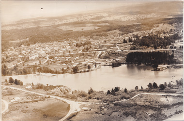
... Black and white reproduced rectangular photograph print... print on paper. Photograph Photograph ...Taken in 1960, depicted is an aerial view of Lake Sambell and the surrounding township. Lake Sambell is a beautiful Victorian recreation lake and urban park with a unique history. It was created in the mid-1800s by the Rocky Mountain Mining company during the gold rush era and used as a mining site until the early 1900s, which brought Europeans into the area. It was turned into a reserve for residents in 1920 and is considered an icon of Beechworth as it represents the development of the community, human endeavour, and the spirit of the landscape.This photograph represents what Lake Sambell looked like in 1960.Black and white reproduced rectangular photograph print on paper.lake sambell, #beechworth, beechworth 1960s, lake, victoria, australian landscape, mining, rocky mountain mining company -
 The Beechworth Burke Museum
Photograph, 1960
... Black and white reproduced rectangular photograph print... and white reproduced rectangular photograph print on paper ...Taken in 1960, depicted is the construction of Lake Sambell, looking west across the lake. Lake Sambell is a beautiful Victorian recreation lake and urban park with a unique history. It was created in the mid-1800s by the Rocky Mountain Mining company during the gold rush era and used as a mining site until the early 1900s, which brought Europeans into the area. It was turned into a reserve for residents in 1920 and is considered an icon of Beechworth as it represents the development of the community, human endeavour, and the spirit of the landscape.This photograph represents additional construction to Lake Sambell as a recreational reserve.Black and white reproduced rectangular photograph print on paper.beechworth lake, lake, lake sambell, construction, #beechworth, australian landscape, beechworth 1960s, victoria -
 The Beechworth Burke Museum
Photograph, 1960s
... Sepia rectangular photograph printed on matte photographic... photograph printed on matte photographic paper Photograph Photograph ...Taken around 1960s, this photograph shows the banks of Lake Sambell. Lake Sambell is named after Mr. L. H. Sambell who was instrumental in the lake's formation. Lake Sambell is the original site of the open sluice operation of Rocky Mountain Mining Company in the 1800s and the early 1900s. In the early 1920s, it was reconstructed as a recreational lake and was formally opened to public on 6 October 1928. The opening event was attended by townspeople and Beechworth's Minister of Lands Mr. Bailey. In the late 1930s to early 1940s, Lake Sambell redeveloped. The first development aimed to raise the banks by six feet to double its present area and to make the water cleaner. Another redevelopment in the 1940s was made possible by the Beechworth and District Progress Association. It involved raising the banks to five feet to provide swimming facilities, paddling pool and caravan park. This photograph holds Historic significance because of its connection to the development of Beechworth district.Sepia rectangular photograph printed on matte photographic paperObverse: Reverse: 3533 /beechworth, water scheme, water reserve, catchments, beechworth water reserve, beechworth catchments, municipal council, lakes, reserve, water supply, political projects, environmental changes, mr. l. h. sambell, sambell, rocky mountain mining company, recreational lake, minister of lands, mr. bailey, swimming pool, paddling pool, caravan park, swimming facilities, lake redevelopment, funding -
 The Beechworth Burke Museum
Photograph
... Sepia rectangular photograph printed on matte photographic... / Velox (paper mark) Sepia rectangular photograph printed on matte ...The photograph depicts two young men standing atop a prominent outcrop at Lake Sambell, with buildings visible on the further shore. The present day park and reserve occupies the site of the former Rocky Mountain Mining Company, an open-cut sluice mine that began operations in the mid-Nineteenth Century and operated until the early 1900s, through the peak of Victoria’s Gold Rush. It was converted into a park and leisure area in the 1920s. Lake Sambell was formally opened to the public on Friday 5th October 1928 and was opened by the Victorian Government’s Minister of Lands, Mr Bailey, as part of initiatives to boost the economies and development of country towns. The lake was named after Mr L.H. Sambell, a shire engineer and secretary of the Forward Beechworth Committee who was involved in promoting the transformation of the mining site and promoting plantation forestry and tourism as alternative industries. £300 to begin the process was provided by Mr J. McConvill, a former resident of Beechworth, who is remembered in a street name adjacent to the lake. An article in the Ovens and Murray Advertiser on Saturday, 5th May, 1917, gives some insight into issues in the Rocky Mountain Mining Company’s final years. The writer details the 1917 annual meeting of the Rocky Mountain Mining Company, stating that locals present appeared ‘well pleased this important local industry is in such a prosperous condition and that future prospects are so encouraging’. The author describes plans to give workers a bonus as evidence of profit-sharing that would ‘bridge the gulf between capital and labour’. The article concludes, however, with the statement that ‘there is a little arithmetical puzzle in the report in connection with the dredging operations I have been unable to solve.' The photograph is significant as it contributes to knowledge about how Beechworth reinvented itself after the Gold rush period, and more broadly how country towns repurpose and redevelop infrastructure and facilities to meet the present needs of their population. Sepia rectangular photograph printed on matte photographic paper. Obverse: nil. Reverse: 3471 / Velox (paper mark)beechworth, beechworth lake, lake sambell, l.h. sambell, mcconvill, rocky mountain mining company, rocky mountain mining co, minister of lands, forward beechworth committee, wallace park-lake sambell development scheme, wallace park lake sambell development scheme, lake, sambell, j. mcconvill, recreation, reserve, park, transformation, repurposed, redeveloped -
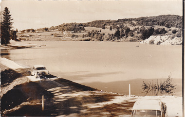
 The Beechworth Burke Museum
Photograph, c1960
... Sepia rectangular photograph printed on matte photographic... rectangular photograph printed on matte photographic paper Photograph ...The photograph depicts a view across the water at Lake Sambell. The image dates from approximately 1960. The present day park and reserve occupies the site of the former Rocky Mountain Mining Company, an open-cut sluice mine that began operations in the mid-Nineteenth Century and operated until the early 1900s, through the peak of Victoria’s Gold Rush. It was converted into a park and leisure area in the 1920s. Lake Sambell was formally opened to the public on Friday 5th October 1928 and was opened by the Victorian Government’s Minister of Lands, Mr Bailey, as part of initiatives to boost the economies and development of country towns. The lake was named after Mr L.H. Sambell, a shire engineer and secretary of the Forward Beechworth Committee who was involved in promoting the transformation of the mining site and promoting plantation forestry and tourism as alternative industries. £300 to begin the process was provided by Mr J. McConvill, a former resident of Beechworth, who is remembered in a street name adjacent to the lake. Residents of Beechworth have worked to raise funds to improve the Lake Sambell reserve several times, such as efforts in the 1930s and 1940s to raise the banks several feet to deepen the water for swimming purposes. Fundraising campaigns include the ‘Ugly Man’ competition conducted on behalf of the Wallace Park-Lake Sambell Development Scheme. The latter competition was run by the Fire Brigade Bend’s team as part of a larger competition called the ‘Mile of Pennies’; it was won by Mr Len Knight of Beechworth’s Commercial Hotel. The ‘Mile of Pennies’ was conducted at a Carnival held on New Year’s Eve, 1947. It was proposed by the Beechworth and District Progress Association. As well as improving swimming facilities, funds were raised to install a caravan park facility near the lake. Funds were also donated by commercial entities, such as £250 received from Zwar Bros. Pty Ltd. The photograph is significant as it shows the level of development of Beechworth in the early to mid-Twentieth Century. Sepia rectangular photograph printed on matte photographic paperObverse: nil. Reverse: 3470 / Velox (paper mark)beechworth, beechworth lake, lake sambell, lake, beechworth and district progress association, forward beechworth committee, ugly man, mile of pennies, wallace park lake sambell development scheme, wallace park-lake sambell development scheme, zwar bros, zwar, l.h. sambell, j. mcconvill, minister of lands, commercial hotel, len knight, rocky mountain mining company, rocky mountain mining co, gold rush, redevelopment, transformation, community fundraising -
 The Beechworth Burke Museum
Photograph, c1960
... Sepia rectangular photograph printed on matte photographic... Obverse: nil Reverse: 3470 Sepia rectangular photograph printed ...The photograph depicts a view across the water at Lake Sambell. The image is thought to date from the 1960s so may show the lake during a period of drought, such as that experienced across South-Eastern Australia in 1967. The present day park and reserve occupies the site of the former Rocky Mountain Mining Company, an open-cut sluice mine that began operations in the mid-Nineteenth Century and operated until the early 1900s, through the peak of Victoria’s Gold Rush. It was converted into a park and leisure area in the 1920s. Lake Sambell was formally opened to the public on Friday 5th October 1928 and was opened by the Victorian Government’s Minister of Lands, Mr Bailey, as part of initiatives to boost the economies and development of country towns. The lake was named after Mr L.H. Sambell, a shire engineer and secretary of the Forward Beechworth Committee who was involved in promoting the transformation of the mining site and promoting plantation forestry and tourism as alternative industries. £300 to begin the process was provided by Mr J. McConvill, a former resident of Beechworth, who is remembered in a street name adjacent to the lake. Residents of Beechworth have worked to raise funds to improve the Lake Sambell reserve several times, such as efforts in the 1930s and 1940s to raise the banks several feet to deepen the water for swimming purposes. Fundraising campaigns include the ‘Ugly Man’ competition conducted on behalf of the Wallace Park-Lake Sambell Development Scheme. The latter competition was run by the Fire Brigade Bend’s team as part of a larger competition called the ‘Mile of Pennies’; it was won by Mr Len Knight of Beechworth’s Commercial Hotel. The ‘Mile of Pennies’ was conducted at a Carnival held on New Year’s Eve, 1947. It was proposed by the Beechworth and District Progress Association. As well as improving swimming facilities, funds were raised to install a caravan park facility near the lake. Funds were also donated by commercial entities, such as £250 received from Zwar Bros. Pty Ltd.The photograph is significant as it shows Lake Sambell at lower water levels, such as may have been experienced during period of drought.Sepia rectangular photograph printed on matte photographic paperObverse: nil Reverse: 3470beechworth, beechworth lake, lake sambell, lake, beechworth and district progress association, forward beechworth committee, ugly man, mile of pennies, wallace park lake sambell development scheme, wallace park-lake sambell development scheme, zwar bros, zwar, l.h. sambell, j. mcconvill, minister of lands, commercial hotel, len knight, rocky mountain mining company, rocky mountain mining co, gold rush, redevelopment, transformation, community fundraising, drought, 1967, 1960s -
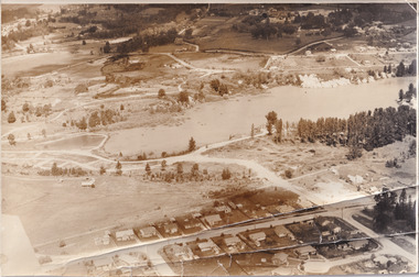
 The Beechworth Burke Museum
Photograph, Unknown
... Black and white reproduced rectangular photograph print... rectangular photograph print on paper. Photograph Photograph ...Aerial view of Lake Sambell, Beechworth with town views. Lake Sambell is a beautiful Victorian recreation lake and urban park with a unique history. It was created in the mid-1800s by the Rocky Mountain Mining company during the gold rush era and used as a mining site until the early 1900s, which brought Europeans into the area. It was turned into a reserve for residents in 1920 and is considered an icon of Beechworth as it represents the development of the community, human endeavour, and the spirit of the landscape.This photograph represents Lake Sambell with town views.Black and white reproduced rectangular photograph print on paper.Reverse: Stampbeechworth lake, lake sambell, aerial photo, construction, australian landscape, #beechworth, victoria -
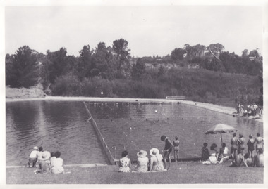 The Beechworth Burke Museum
Photograph, 1960s
... Black and white reproduced rectangular photograph print... reproduced rectangular photograph print on paper. Photograph ...Taken in the 1960s, depicted are approximately twenty-nine male and female spectators at a school swimming carnival on Lake Sambell near the caravan park. Lake Sambell is a beautiful Victorian recreation lake and urban park with a unique history. It was created in the mid-1800s by the Rocky Mountain Mining company during the gold rush era and used as a mining site until the early 1900s, which brought Europeans into the area. It was turned into a reserve for residents in 1920 and is considered an icon of Beechworth as it represents the development of the community, human endeavour, and the spirit of the landscape. This photograph represents the post-gold rush era use of Lake Sambell as a recreational reserve. Swimming carnivals were held at the lake and considered a social event for the Beechworth community.Black and white reproduced rectangular photograph print on paper.Reverse: Community/ Swimming pool 1960s/ near the caravan park/ Lakes?lake swimming pool, lake swimming, beechworth carnival processions, carnival, #beechworth, beechworth 1960s, victoria -
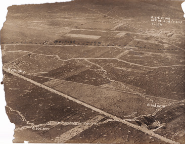 The Beechworth Burke Museum
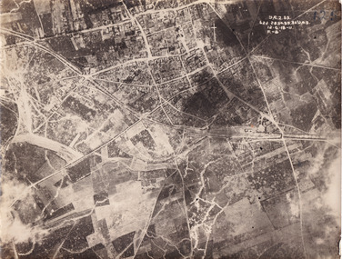
Photograph
... Sepia rectangular photograph printed on matte photographic... rectangular photograph printed on matte photographic paper. Photograph ...Taken some time between 1914-18, the photograph depicts an aerial view of trenches in France. The image mostly shows rural landscape, although there is a house in the bottom right corner. A dotted line has been drawn across the photograph, marking the section of trenches that belonged to British forces during World War I. It is believed that the line marking on this record denotes a section of the Western Front. The Western Front was the main theatre of war during World War I. Following the outbreak of war in August 1914, the German Army opened the Western Front by invading Luxembourg and Belgium, then gaining military control of important industrial regions in France. The German advance was halted with the Battle of the Marne. Following the Race to the Sea, both the French-British and German armies dug in along a meandering line of fortified trenches, stretching from the North Sea to the Swiss frontier with France. Between 1915 and 1917 there were several offensives along the Western Front. The attacks employed massive artillery bombardments and massed infantry advances. Entrenchments, machine gun emplacements, barbed wire and artillery repeatedly inflicted severe casualties during attacks and counter-attacks and no significant advances were made. Among the most notable of these offensives were the Battle of Verdun (1916), the Battle of the Somme (1916), and the Battle of Passchendaele (1917).The record is historically significant due to its connection to World War I. This conflict is integral to Australian culture as it was the single greatest loss of life and the greatest repatriation of casualties in the country's history. Australia’s involvement in the First World War began when the Australian government established the Australian Imperial Force (AIF) in August 1914. Immediately, men were recruited to serve the British Empire in the Middle East and on the Western Front. The record has strong research potential. This is due to the ongoing public and scholarly interest in war, history, and especially the ANZAC legend, which is commemorated annually on 25 April, known as ANZAC Day.Sepia rectangular photograph printed on matte photographic paper.Obverse: A.3FE.O.146 / G2R 29 . 6 . 18 (Y p.m) / F= 10 1/4 / British Line / ------------------------------------------ / P. 250 1040 / 0. 30d. 0010 / 0. 30d. 3070 /military album, military, war, wwi, world war i, france, great britain, trenches, village, rural, western front -
 The Beechworth Burke Museum
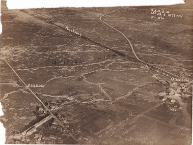
Photograph
... Sepia rectangular photograph printed on matte photographic...-11 / F.-(?)" / Sepia rectangular photograph printed on matte ...Taken some time between 1914-18, the photograph depicts an aerial view of Villers-Bretonneux in France, a region which was part of the Western Front during World War I. The image mostly shows rural landscape. The Western Front was the main theatre of war during World War I. Following the outbreak of war in August 1914, the German Army opened the Western Front by invading Luxembourg and Belgium, then gaining military control of important industrial regions in France. The German advance was halted with the Battle of the Marne. Following the Race to the Sea, both the French-British and German armies dug in along a meandering line of fortified trenches, stretching from the North Sea to the Swiss frontier with France. The First Battle of Villers-Bretonneux occurred between 30 March - 5 April 1918. It took place during Operation Michael, part of the German Spring Offensive on the Western Front. The offensive began against the British Fifth Army and the Third Army on the Somme, and pushed back the British and French reinforcements on the north side of the Somme. The capture of Villers-Bretonneux, close to Amiens, a strategically important road and rail-junction, would have brought the Germans within artillery-range. In late March, troops from the Australian Imperial Force were brought south from Belgium as reinforcements to help shore up the line. In early April, the Germans launched an attack to capture Villers-Bretonneux. After a determined defence by British and Australian troops, the attackers were close to success until a counter-attack by the 9th Australian Infantry Brigade and British troops late in the afternoon of 4 April restored the situation and halted the German advance on Amiens. The Second Battle of Villers-Bretonneux occurred between 24 - 27 April 1918, during the German Spring Offensive to the east of Amiens. It is notable for being the first occasion on which tanks fought against each other. A counter-attack by two Australian brigades and a British brigade during the night of 24 April partly surrounded Villers-Bretonneux, and on 25 April, the town was recaptured. On 26 April, the role of the Moroccan division of the French army was crucial in pushing back German units. Australian, British and French troops nearly restored the original front line by 27 April.The record is historically significant due to its connection to World War I. This conflict is integral to Australian culture as it was the single greatest loss of life and the greatest repatriation of casualties in the country's history. Australia’s involvement in the First World War began when the Australian government established the Australian Imperial Force (AIF) in August 1914. Immediately, men were recruited to serve the British Empire in the Middle East and on the Western Front. Additionally, the record's significance is enhanced by its depiction of Villers-Bretonneux. The battles that occurred in this town during World War I are especially historically significant to Australia as this is where the Australian Imperial Force had one their greatest World War I victories. An Australian flag still flies over Villers-Bretonneux in the present. Furthermore, a plaque outside the Villers-Bretonneux Town Hall recounts the battles fought to save the town in 1918. Kangaroos feature over the entrance to the Town Hall, and the main street is named Rue de Melbourne. More officially, recognition of the significance of the battle in Villers-Bretonneux is found at the Australian National Memorial, which was built just outside the town. It commemorates all Australians who fought in France and Belgium and includes the names of 10,772 who died in France and have no known grave. Each year, a small ceremony is held at the memorial to mark the sacrifice made by the soldiers. Lastly, the record has strong research potential. This is due to the ongoing public and scholarly interest in war, history, and especially the ANZAC legend, which is commemorated annually on 25 April, known as ANZAC Day.Sepia rectangular photograph printed on matte photographic paper.Obverse: yAE.2.35. / 125 / 62d.2834.35.36.VA.5. / 12.G.18-11 / F.-(?)" /military album, wwi, world war i, villers-bretonneux, australian imperial force, aif, france, war, army, conflict, germany, 1918, battle -
 The Beechworth Burke Museum
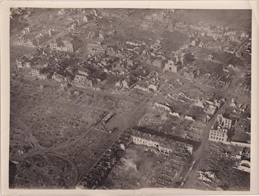
Photograph, c1914
... Black and white rectangular photograph printed...: Villers Brut / Black and white rectangular photograph printed ...Aerial photograph of a battle field in France during World War OneBlack and white rectangular photograph printed on photographic paperObverse: Railway / British Line (in pen) / Reverse: Villers Brut /military album, burke museum, beechworth, beechworth museum, world war one, wwi, trenches, aerial photo, aerial photo trenches -
 The Beechworth Burke Museum
Photograph, c1914
... Black and white rectangular photograph printed... and white rectangular photograph printed on photographic paper ...Aerial photograph of a battle field in France during World War OneBlack and white rectangular photograph printed on photographic paperReverse: 6534 / Australian Official Photographs, No. E1253 /military album, burke museum, beechworth, beechworth museum, world war war, wwi, trenches, aerial photo, battlefield -
 The Beechworth Burke Museum
Photograph, Unknown
... Black and white rectangular photograph printed... / Vic. / Black and white rectangular photograph printed ...The A1 Gold Mine is located north of Woods Point, near Jamieson, in the Upper Goulburn region of Victoria. Gold was discovered at the A1 site in 1861 and mining operations began in 1864. The A1 Mine Settlement refers to a small township known variously as Castle Reef, Castle Point, and Raspberry Creek, which developed in the 1860s around mining industry centred on a crushing machine that worked the three gold reefs in the area. Historically, the name "A1"referred to the high quality of gold found in the quartz reefs at depths of at least two thousand feet. Along with the Morning Star mine at Woods Point, the A1 gold mine produced almost sixty percent of Victoria's gold output in the 1950s to 1970s and continued operating until 1992 when it went into administration. Operations at the site were revived in 2016 and the A1 Mine is now considered one of Victoria's premier gold mines. The A1 mine is part of the extensive and prospective Lachlan Fold Belt, a north-west trending belt of tightly folded Early Devonian sedimentary rocks extending from New South Wales to Victoria. Mineralisation is hosted within or immediately adjacent to diorite dykes. Contemporary development of the 'Queens Lode' at the A1 mine signals a move from high-grade, narrow vein airleg mining into larger scale, mechanical mining designed to increase ore production volume. This original, undated photograph of the A1 Mine appears to depict an area or phase of disuse or abandonment. The aged and humble appearance of the cottage suggests association with the historical A1 Mine Settlement, therefore the image may have been taken prior to the 1950s-1970s revival period in which the A1 mine is known to have produced high gold yields. The photograph contributes to our understanding of the A1 Gold Mine's impact on the landscape and the social, environmental impacts of mining on communities and may be compared with others in the Burke Museum's extensive collection of mining photographs to deepen our understanding of mining in the Jamieson area.Black and white rectangular photograph printed on photographic paperReverse: 5577 / A1 Mine / Near Jamieson / Vic. /burke museum, beechworth museum, beechworth, gold fields, gold rush, victorian gold rush, mining tunnels, gold ming history, colonial australia, australian gold rushes, mining technology, beechworth historic district, indigo gold trail, indigo shire, upper goulburn shire, jamieson, woods point-walhalla goldfield, a1 gold mine, victorian high country, modern mining methods, orogenic gold province, gold mineralisation, devonian, dykes -
 The Beechworth Burke Museum
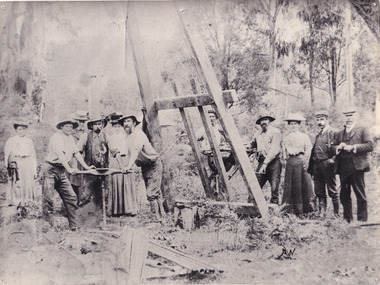
Photograph, c1900
... Black and white rectangular photograph printed... photograph printed on photographic paper Photograph Photograph ...A black and white photograph depicting seven men and four women surrounded by tunnel boring machinery. A tunnel boring machine (TBM), also known as a "mole", is a machine used to excavate tunnels with a circular cross section through a variety of soil and rock strata. They may also be used for microtunneling. They can be designed to bore through anything from hard rock to sand. Tunnel boring machines are used as an alternative to drilling and blasting (D&B) methods in rock and conventional "hand mining" in soil. TBMs have the advantages of limiting the disturbance to the surrounding ground and producing a smooth tunnel wall. This significantly reduces the cost of lining the tunnel, and makes them suitable to use in heavily urbanised areas. The major disadvantage is the upfront cost. TBMs are expensive to construct, and can be difficult to transport. The longer the tunnel, the less the relative cost of tunnel boring machines versus drill and blast methods. This is because tunneling with TBMs is much more efficient and results in shortened completion times, assuming they operate successfully. Drilling and blasting however remains the preferred method when working through heavily fractured and sheared rock layers.This photograph is significant as it shows the machinery used and attire worn by men and women during the gold rush era. Black and white rectangular photograph printed on photographic paperburke museum, mining, beechworth, boring machinery, excavate, gold, gold fields, gold rush, miners -
 The Beechworth Burke Museum
Photograph, c1920
... A black and white rectangular photograph printed... then Parkinsons Sluicing. A black and white rectangular photograph printed ...This photo shows the large mining cavity with a hydraulic sluicing machine in operation at Baarmutha Three Mile Mine, Beechworth . The Beechworth Mining District was one of six mining districts established by the Governor-in-Council on 4 January 1858 under the provisions of An Act for Amending the Laws Relating to the Goldfields (21 Vic no.32). The District was further divided into seven divisions: Spring Creek, Snake Valley, Three Mile Creek, Buckland, Woolshed, Yackandandah and Omeo. The boundaries of each of these divisions and of the whole district are described in the Governor-in-Council's proclamation printed in the Government Gazette, 5 January 1858, pages 3-5. Hydraulic mining is a form of mining that uses high-pressure jets of water to dislodge rock material or move sediment. In the placer mining of gold or tin, the resulting water-sediment slurry is directed through sluice boxes to remove the gold. It is also used in mining kaolin and coal.This photograph shows the impact the gold rush era had on Australia and the earth.A black and white rectangular photograph printed on photographic paperCopied from original on loan film (WEBB QLD) / Donated 2009 NOV/ Baarmutha Three Mile Mine c1920-1950/ Managed by John Weir Peter Jereen Jack Cox / Owned by Plain Bros then Parkinsons Sluicing.mining, gold fields, beechworth, gold rush, burke museum, photograph, mining cavity, hydraulic mining, hydraulic sluicing, baarmutha -
 The Beechworth Burke Museum
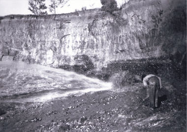
Photograph
... A colour rectangular photograph printed on glossy... mining Reverse: 6855 / A colour rectangular photograph printed ...This image shows an unknown location in the area of Beechworth that was possibly used as a sluicing mining site for gold during the Victorian Gold Rush. This era saw an influx of Chinese immigrants and Australian prospectors hoping to strike it rich on the fields. Many companies such as the Rocky Mountain Extended Gold Sluicing Company Ltd and the Cocks Pioneer Gold &Tin Sluicing Company also set up mines in the area. This site may be the location of one of these company's mines. The wooden logs are reminiscent of known sluicing operations in the era from that time. Sluicing involved the use of high-pressured hoses to clear away soil from earth that had been dug up by miners and was a popular method of excavation in the area, although it had severe impacts on the environment.The search for gold is ingrained into the history of Victoria and therefore, images like this one which portray an open cut sluicing site can reveal important information for society and technology for the date when the photograph was taken. This image is of important historical significance for its ability to convey information about sluicing and the methods used to find gold. It also shows a location where sluicing was undertook which provides insight into the impact of sluicing on the environment at a time when it was done.A colour rectangular photograph printed on glossy photographic paperReverse: 6855 /beechworth, gold rush, sluicing, mining -
 The Beechworth Burke Museum
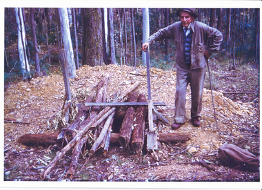
Photograph, c1960
... Colour rectangular photograph printed on glossy... Obverse: Reverse: 6857/ Colour rectangular photograph printed ...The date this photograph was taken is unknown. Estimated date 1960-70s. The gentleman in the photograph and location the photograph was taken are also unknown. Perhaps in the Beechworth or Stanley area. Unknown what the photo is referencing, however, there is perhaps an old wooden pump house near a large body of water. Located inside the pump house is an old rusted steam engine, dated c1900, which could have controlled the flow of water. The photo is associated to another record, 6856 as it has the same elderly gentlemen in the image. He is able to be identified through wearing the same clothes and distinctive hat in both photographs. The photograph could be associated to mining as the gentleman is standing next to a small mine site in a related record. Colour rectangular photograph printed on glossy photographic paper. Obverse: Reverse: 6857/ colour photograph, beechworth, burke museum, mining, miners, stanley -
 The Beechworth Burke Museum
Photograph
... Colour rectangular photograph printed on glossy... photograph printed on glossy photographic paper. Photograph ...The date this photograph was taken is unknown. Estimated date 1960-70s. The gentleman in the photograph and location the photograph was taken are also unknown. Perhaps in the Beechworth or Stanley area. The photo is associated to another record, 6856 as it has the same elderly gentlemen in the image. He is able to be identified through wearing the same clothes and distinctive hat in both photographs. The photograph is associated to mining as the gentleman is standing next to a small mine site where perhaps a windless or whip was mounted over the entrance of the shaft. The windless was a structure mounted over the shaft, fitted with a hand-cranked winch, which was usually constructed from wood that would have been found in the surrounding area. Colour rectangular photograph printed on glossy photographic paper.Obverse: Reverse: 6856/ mining, windlass, whip, empty record -
 The Beechworth Burke Museum
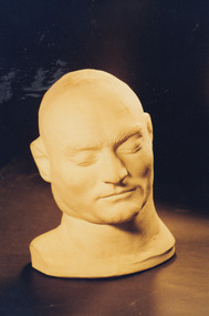
Photograph
... Colour rectangular photograph printed on gloss photographic... Obverse: Reverse: AGFA Colour rectangular photograph printed ...A death mask is a plaster or wax mould made of a human face shortly after death (around 30 minutes after the execution). The intention was to capture the likeness of the individual and maintain their facial expression and features before these became distorted in death. They differ from their counterparts the life masks which were made to preserve the likeness of an individual while alive. Death masks were often replicated and sold to various institutions and private buyers. Death masks were created for a variety of reasons. Organisations like museums and scientific institutes collected these masks to support the study of phrenology. Phrenology is the study of the conformation of a skull in an effort to understand the mental faculties and traits of an individual. This was undertaken in a period in which it was argued that the shape of a head could provide detailed knowledge into personality. In addition, death masks were also created to aid effigy making, as tools for sculpture and as objects of veneration. Death masks were often placed on display as objects of curiosity. Edward “Ned” Kelly was convicted of murder on the 29th of October 1880 and executed by hanging on the 11th of November that same year. In the 1800s it was common practice for authorities to make a death mask of an executed criminal. In Kelly’s case, there were multiple copies made of his death mask, one of which is in the collection of the Burke Museum. Copies of the official death Mask (attributed to Maximilian Kreitmayer) have been made by artists including Max Meldrum (1875-1955). It depicts the head, neck and partial right shoulder of Ned Kelly. Whilst generally considered to be a ‘pseudoscience’ today, phrenology and the study of the reception and use of artefacts like Ned Kelly’s death mask, can provide valuable insight into a past era’s views of personality and the human body. This mask presents a unique three-dimensional depiction of Ned Kelly shortly after his execution which is unlike any other depiction of him. It can provide vital information as to the use of death masks in Victoria and their popularity in the 1800s. These masks were mostly done of criminals and used for exhibition purposes alongside phrenological study. Phrenologist AS Hamilton used Kreitmayer’s replication of the mask (displayed in Kreitmayer’s Bourke Street waxworks the day after Kelly’s death) to report a detailed phrenological analysis on Ned Kelly and concluded from his research that the deceased had an “enormous self-esteem”. Portraits of living people represent the way they themselves and/or the artists wished themselves to be remembered. The death mask contrasts this and therefore, creates a likeness of a person in their entirety and not just an ideal representation. Therefore, the study of such artefacts and their history of use and disuse can provide interesting information valuable to understanding the past. Colour rectangular photograph printed on gloss photographic paper.Obverse: Reverse: AGFA kelly album, ned kelly, death mask, kreitmayer, old melbourne gaol, phrenology, craneology, 1800s, pseudoscience, burke musuem, max meldrum -
 The Beechworth Burke Museum
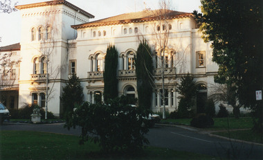
Photograph, c.2000
... Coloured rectangular photograph printed on gloss... Coloured rectangular photograph printed on gloss photographic paper ...This photograph was captured on an undisclosed date and by an unidentified photographer. It was printed in colour through the company AGFA which is a Belgian-German Multinational Corporation. This business prints, develops, manufactures and distributes digital imaging products, software and systems. It was founded in 1967 and continues to operate today. Beechworth's Mayday Hills was chosen as the site of Victoria's newest asylum, at the time, due to the landscape and altitude. The hilltop atmosphere and the native fauna, it was argued, would assist in the cure of the patients kept at the hospital (Wood 1985, 122). The positioning of the hospital had a beneficial effect on the rural town. A pamphlet published by James Ingram and Son (1849) reveal that famous landmarks in Beechworth which included the Post Office, Gaol, Courthouse and Asylum "demonstrate the appreciation of Beechworth by the Government not only as as important district center, but also as a site unrivaled as a sanitarium". There were other locations in contention at the time, but ultimately Beechworth was chosen (Craig 2000, 33). Prior to the creation of the Asylum in Beechworth, those charged with having mental illnesses or, as it was termed, "insanity" were unable to be properly cared for in the Gaol (which is where they were often sent). John Buckley Castieau wrote, in 1861 for the Ovens and Murray Advertiser, that the Gaol was unable to properly care for those classified then as "insane" but that they would endeavor to treat them above the other inmates (which he notes is not always the case in other establishments). Castieau wrote this in favour of supporting the building of the Mayday Hills Hospital in Beechworth. It was stated that at the time the Mayday Hills Hospital was built, there were 83 prisoners kept in the Gaol who were to be rehoused to the Hospital on the grounds of "insanity". The classification as someone as "insane", in this period of time is a reflection on the inability to cure and understand illnesses of the mind during the mid to late 1800s. Opening on the 24th of October 1867, the Mayday Hills Hospital was originally named the "Ovens Lunatic Asylum", a title which is very much a product of its time. Whilst controversial, changes to the name is part of the history of the Hospital and can provide much insight into the understanding of mental illness throughout history and the use/disuse of this term provides information into the reception/changing opinions of mental illness in society. The Hospital would later become known as the "Mayday Hills Asylum" and/or "Mayday Hills Hospital" with the latter being the most commonly used title. An article in the Ovens and Murray Advertiser notes that on the 7th of March 1865, the foundation stone of the Hospital was laid (it would officially open in 1867) and that it was such a moment of accomplishment and joy for Beechworth that a letter to the editor even suggested that there should be a holiday dedicated to the day the foundation stone as laid. This reveals an extent to which the townspeople of early Beechworth valued the construction of the Hospital in their town. It provided the town with a sense of prestige and honour.At first glance, the remains of the Mayday Hills Hospital in Beechworth, Victoria, inspire tragedy, trauma and beauty. The buildings themselves, with their Italianate style Renaissance architecture designed by J.J. Clark (Craig 2000, 49 & Smith 2016, 203) reflect a bygone period of European and Australian history. The gardens provide a sense of tranquility and beauty. The experience of those within these walls remains a valuable area of study to provide a more complete understanding. This particular hospital is considered the fourth of its like and one of three identified as the largest of their kind. The Mayday Hills Hospital is a sister to the Kew and Ararat Asylums in Melbourne which are both located in relative proximity. Understanding the role of the Mayday Hills Hospital in Beechworth history is integral to understanding the development of the goldfields town, but also for providing important information as to the history of caring for, and the reception of, mental illnesses in Australian and wider European history. Mayday Hills provides a case study which can be researched through oral history, an analysis of the grounds/buildings and through images like this postcard which portray the structure in a highly deliberate manner. Images like this depict the strong façade of the Hospital and provide a glimpse into the tranquility of the gardens. This has been done deliberately to provide a sense of comfort and healing about the building to those looking from the outside. Further research into the importance of the Hospital in Beechworth and it's connection to the town will be supported through images like these kept in the Mayday Hills photo album in the collection of the Burke Museum.Coloured rectangular photograph printed on gloss photographic paper.Reverse: AGFAbeechworth, mayday hills, mayday hills asylum, mental health, history of mental health, asylum, 1860s, gold town, north-east victoria, kew asylum, ararat asylum -
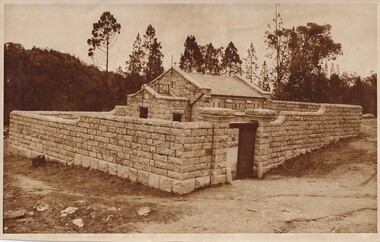 The Beechworth Burke Museum
Photograph, Beechworth Candid Photos, Unknown c1869-1940
... A sepia toned rectangular photograph printed on matte paper.... Street 3747/ A sepia toned rectangular photograph printed ...The Powder Magazine was built in 1859 by T Dawson and Company for fifteen hundred pounds and was restored in 1966 by the National Trust. The building was constructed to store black-powder used by miners on the goldfields for blasting for mining and quarrying as legally, miners had to leave bulk gunpowder the Powder Magazine overnight. Due to the passing of an 1857 act regulating the importation, transportation and importation of black powder, several Powder Magazines like the Beechworth Powder Magazine were constructed. The Magazine Powder is uniquely designed to ensure that in the chance of an explosion, the explosion is minimalized by travelling vertically rather than horizontally. The Powder Magazine was constructed using granite, slate roofing and a high stone wall and includes several safety features including wooden nails, lightning rod and a solid outer wall. This photograph is historically significant as it documents the development of laws related to mining, the actions taken to ensure the safety of those nearby potentially dangerous equipment and the architectural skills to design a storage facility to minimize damage caused by a potential explosion. A sepia toned rectangular photograph printed on matte paper.Reverse: Beechworth Candid Photos/ Phone 281570/ 5 Finch Street 3747/historic building, beechworth historic building, powder magazine, beechworth -
 The Beechworth Burke Museum
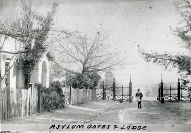
Photograph - Photograph Reproduction, 1890
... Black and white rectangular photograph printed on paper...: 3451-1/ Black and white rectangular photograph printed on paper ...The photo is taken in 1890 and a man is depicted, entering the main gates of the Mental Hospital at Beechworth, with the lodge on his right side. The man is dressed according to the australian fashion of that time, wearing a dark suit and a top hat. The countryside surrounding the Hospital is in the background. The Mayday Hills Hospital was constructed between 1864 and 1867, with buildings created in a number of periods. It formally opened on 24 October 1867 and, along with the Ovens Hospital and the Benevolent Asylum, made Beechworth a prominent social welfare centre in Victoria. The need for an institution of this kind was arisen due to the increased number of people with mental disturbances (induced by the harsh living conditions on the goldfields) and the remoteness of the district from Melbourne. The site was chosen for its panoramic view of the countryside, the hilltop atmosphere and the native fauna, all contributing to the cure of patients. It was designed in Italianate style and around 250 workmen were employed for its construction. The Hospital was originally named the “Ovens Lunatic Asylum” but, during the centenary celebrations in 1967, the name was officially changed to “Mayday Hills Hospital”, showing the gradual shift in the perception and understanding of mental health conditions over the last decades. The Hospital lies on the traditional land of the Kulin Nation.This photograph is historically significant as it provides an insight into the location, surroundings and the exterior of the Mayday Hills Hospital at the end of the 19th century. It also contributes to the understanding of the district`s development and its importance to the course of Victoria`s history. Moreover, it adds information to the scientific research and the way mental health conditions were treated at that time.Black and white rectangular photograph printed on paper unframed.Obverse: Asylum Gates & Lodge/ Reverse: 3451-1/mental hospital, beechworth, australian fashion, dark suit, top hat, countryside, mayday hills hospital, ovens hospital, benevolent asylum, institution, mental disturbances, social welfare, living conditions, goldfields, workmen, italianate style, kulin nation, mental health, ovens lunatic asylum, patients -
 The Beechworth Burke Museum
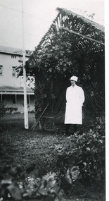
Photograph - Photograph Reproduction, 1998
... Black and white rectangular photograph printed on paper... Reverse: 3445/ Black and white rectangular photograph printed ...The photograph, created in 1998, is a copy of the original one, depicting a nurse in uniform at the Mental Hospital in Beechworth, with a fern house behind her. In the background, the two-storey building is in view, along with the covered walkway. The institution had to operate with serious shortage of female nurses for long periods of time. During the 1880s, small houses (cottages) were built to offer accommodation for the nurses living in the hospital and in 1937 began the construction of a nurses` hostel. In 1962 the upper level of the Nurses` Home was converted into a Nurses` Training School. The Mayday Hills Hospital was constructed between 1864 and 1867, with buildings created in a number of periods. It formally opened on 24 October 1867 and, along with the Ovens Hospital and the Benevolent Asylum, made Beechworth a prominent social welfare centre in Victoria. The need for an institution of this kind was arisen due to the increased number of people with mental disturbances (induced by the harsh living conditions on the goldfields) and the remoteness of the district from Melbourne. The two-storey buildings, designed in Italianate style, and the three-storey towers at the front, were influenced by the asylum at Colney Hatch in England. Large masses of granite were excavated for its foundation and around 250 workmen were employed for its construction. The building, divided into six sections, was comprised of dormitories, doctors` rooms and plenty ancillary rooms and facilities, such as laundries, reading rooms, a concert hall and cooking areas. The site was chosen for its panoramic view of the countryside, the hilltop atmosphere and the native fauna, all contributing to the cure of patients. The Hospital was originally named the “Ovens Lunatic Asylum” but, during the centenary celebrations in 1967, the name was officially changed to “Mayday Hills Hospital”, showing the gradual shift in the perception and understanding of mental health conditions over the last decades. The Hospital lies on the traditional land of the Kulin Nation.This photograph is historically significant as it provides an insight into the everyday life of staff living within the walls of the Mayday Hills Hospital. It also offers important information about the location and the exterior of the Hospital and contributes to the understanding of the district`s development and its importance to the course of Victoria`s history.Black and white rectangular photograph printed on paper unframed.Reverse: 3445/mental hospital, beechworth, fern house, female nurses, nurses` home, nurses` training school, nurses` hostel, mayday hills hospital, ovens hospital, colney hatch, two-storey buildings, italianate style, benevolent asylum, ovens lunatic asylum, kulin nation, workmen, covered walkway, granite, hilltop atmosphere, mental health -
 The Beechworth Burke Museum
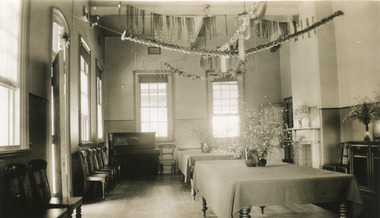
Photograph, L. Maher, 1936
... Black and white rectangular photograph printed... rectangular photograph printed on photographic paper Photograph ...Mayday Hills Mental Hospital was originally constructed in 1864 under the name of the Beechworth Lunatic Asylum. It was built for locals in need of help who were kept in the local gaol. In its first decade, the residents of the hospital were used as menial labourers but over time, as mental healthcare progressed, were cared for in more nuanced ways. This site became a training hospital for nurses in the 1960's. Eventually, mental health patients were moved to other care facilities and Mayday Hills was operating as a geriatric care facility. It was closed in 1995, after which the buildings and their grounds were purchased to La Trobe University to be used as a campus. The university sold the site in 2011 to private ownership. The image depicts an interior room which is presumed to be a dining or common room. This space has been decorated for Christmas.Mayday Hills Mental Hospital is a historically significant site for many factors. It is representative of healthcare practice in nineteenth century Victoria. It contains rare examples of construction and architecture. It is also significant for aesthetic and technical reasons. Black and white rectangular photograph printed on photographic paperObverse: PRINTED BY/ L.MAHER/ BEECHWORTH/ 1997.2702mayday, mayday hills hospital, mayday hills, mayday hills mental asylum, beechworth lunatic asylum, lunatic asylum, beechworth, gaol, beechworth hospital for the insane, beechworth mental hospital, mental hospital, hospital, nurse, nurses quarters, la trobe university, training facility, christmas, christmas party -
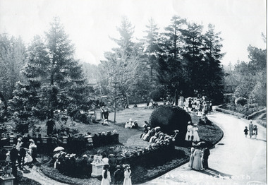 The Beechworth Burke Museum
Photograph, 1880 - 1900
... Black and white photograph printed on matte photographic... photograph printed on matte photographic paper Photograph Photograph ...Mayday Hills Mental Hospital was originally constructed in 1864 under the name of the Beechworth Lunatic Asylum. It was built for locals in need of help who were kept in the local gaol. In its first decade, the residents of the hospital were used as menial labourers but over time, as mental healthcare progressed, were cared for in more nuanced ways. This site became a training hospital for nurses in the 1960's. Eventually, mental health patients were moved to other care facilities and Mayday Hills was operating as a geriatric care facility. It was closed in 1995, after which the buildings and their grounds were purchased to La Trobe University to be used as a campus. The university sold the site in 2011 to private ownership. This image depicts people enjoying the grounds and gardens.Mayday Hills Mental Hospital is a historically significant site for many factors. It is representative of healthcare practice in nineteenth century Victoria. It contains rare examples of construction and architecture. It is also significant for aesthetic and technical reasons.Black and white photograph printed on matte photographic paperReverse: at the Beechworth Lunatic Asylum/ (wade)/ do not copy - copy for Burke Museum/ for collection only only/ BMM 8326mayday, mayday hills hospital, mayday hills, mayday hills mental asylum, beechworth asylum, beechworth lunatic asylum, beechworth mental hospital, beechworth institution, healthcare, mental health, nurses quarters, nurses, gaol, garden, garden party -
 The Beechworth Burke Museum
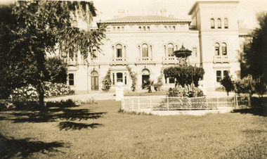
Photograph, 1930
... Black and white photograph printed on matte photographic... (Watermark) Black and white photograph printed on matte photographic ...Mayday Hills Mental Hospital was originally constructed in 1864 under the name of the Beechworth Lunatic Asylum. It was built for locals in need of help who were kept in the local gaol. In its first decade, the residents of the hospital were used as menial labourers but over time, as mental healthcare progressed, were cared for in more nuanced ways. This site became a training hospital for nurses in the 1960's. Eventually, mental health patients were moved to other care facilities and Mayday Hills was operating as a geriatric care facility. It was closed in 1995, after which the buildings and their grounds were purchased to La Trobe University to be used as a campus. The university sold the site in 2011 to private ownership. This image depicts the front facade of the building and a portion of the gardens, including a fountain. Mayday Hills Mental Hospital is a historically significant site for many factors. It is representative of healthcare practice in nineteenth century Victoria. It contains rare examples of construction and architecture. It is also significant for aesthetic and technical reasons.Black and white photograph printed on matte photographic paperReverse: Mental Hospital/ Beechworth Lunatic Asylum/ Xmas 1930/ 8190 VELOX (Watermark)mayday, mayday hills hospital, mayday hills, mayday hills mental asylum, beechworth, beechworth asylum, beechworth lunatic asylum, beechworth hospital for the insane, garden, gardens & parks, architecture, historic victorian architecture, healthcare, health, fountain, la trobe university