Showing 4913 items matching "south yarra"
-
 Greensborough Historical Society
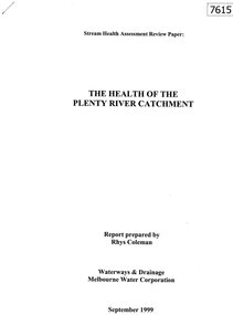
Document - Report, Rhys Coleman, The Health of the Plenty River Catchment 1999, 1999_09
Report prepared by Rhys Coleman for Waterways and Drainage, Melbourne Water Corporation, discusses the health of the Plenty River catchment from upstream of Toorourrong Reservoir, through Whittlesea and Mernda, South Morang and Plenty to Greensborough and confluence with the Yarra River.31 p., tables.plenty river, melbourne water corporation -
 Seaworks Maritime Museum
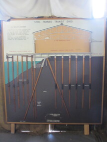
Diagram
Cross section of wharves and steel framed sheds built along the Yarra river between the 1920s and 1960s. The South Melbourne side of the Yarra River is reclaimed swamp land. Without a solid foundation for the construction of the wharves and transit sheds, extended piles were sunk into the mud to support the wharf and shed structures. An example of this design may be found at 5 South Wharf which was built in the 1930s. The transit sheds gave shelter for cargo while waiting to be loaded onto a ship or to be collected by truck after being unloaded from a ship. The transit shed became surplus to requirements with the introduction of containers.Wooden diagram of a transit shed featuring a shed sitting atop mud with some water. It shows the splices sitting in the mud to support the shed. "Steel Frames Transit Shed/ 15 South Wharf/ Model of Typical wharf construction/ of 1940- made for the opening of/ the "new" 15 South wharf shed (1944),/ Note the deep piles and elevated/ rear of the shed to allow for the truck/ trays./ This shed feature disappeared/ from port construction with the/ coming of the container era/ reinforced wharf apron/ 3 ton travelling crane/ reinforced concrete shed floor/ concrete road/ water level/ concrete pile cap/ cradled piles/ timber pile splices/ mud/ mild steel pile splices/ 110 ft pile" "On loan from Port of Melbourne Authority" -
 Mission to Seafarers Victoria
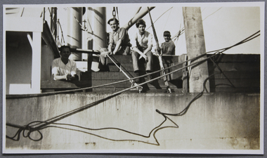
Photograph, S.S. Buchanness
In an article from the Argus, Monday 7 March 1927, page 21: "Surprise was caused on the waterfront yesterday by the appearance of the Reardon Smith line steamer Buchanness, which armed in Hobson's Bay with a list to port of more than 15deg. The vessel anchored off Gellibrand yesterday morning, and a consultation was held concerning the advisability of attempting the passage up the Yarra. The list changed to 12deg. before the tug James Paterson came alongside the Buchanness, and the steamer was piloted to a berth at No 18 South Wharf by Captain K.A. Forbes. The list was caused by the consumption of the fuel oil from bunkers below the waterline and the consequent overbalancing of the vessel by the heavy deck cargo. This wass not considered dangerous by either the master of the vessel or the pilot, both of whom stated that a ship carrying timber was liable to become unstable to some extent without showing any tendency to heel over. The Buhanness comes from North Pacific lumber ports with 4,300,000 super feet of red wood, oregon, and spruce timber, all of which will be discharged at this port to the agency of C.A. Wilms and Son. The discharge will occupy about three weeks.weller album, s.s. buchanness, timber, lumber, 1927, oregon -
 Mission to Seafarers Victoria
Photograph
In an article from the Argus, Monday 7 March 1927, page 21: "Surprise was caused on the waterfront yesterday by the appearance of the Reardon Smith line steamer Buchanness, which armed in Hobson's Bay with a list to port of more than 15deg. The vessel anchored off Gellibrand yesterday morning, and a consultation was held concerning the advisability of attempting the passage up the Yarra. The list changed to 12deg. before the tug James Paterson came alongside the Buchanness, and the steamer was piloted to a berth at No 18 South Wharf by Captain K.A. Forbes. The list was caused by the consumption of the fuel oil from bunkers below the waterline and the consequent overbalancing of the vessel by the heavy deck cargo. This wass not considered dangerous by either the master of the vessel or the pilot, both of whom stated that a ship carrying timber was liable to become unstable to some extent without showing any tendency to heel over. The Buhanness comes from North Pacific lumber ports with 4,300,000 super feet of red wood, oregon, and spruce timber, all of which will be discharged at this port to the agency of C.A. Wilms and Son. The discharge will occupy about three weeks.weller album, s.s. buchanness, oregon, timber, lumber, 1927 -
 Mission to Seafarers Victoria
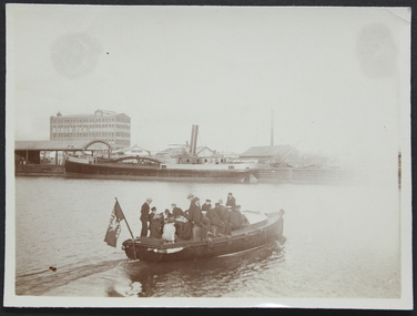
Photograph - Photograph, Sepia, circa 1910
... launch southern cross yarra river australian wharf south wharf ...The motorboat Southern Cross was used for ship visits and also to Bring sailors back to the Mission or picnics.A group of ladies and seamen sitting on the "Southern Cross", the Mission's motor launch, leaving the Australian Wharf and crossing the Yarra River. In the background we can see the "Robur Tea House" warehouse and the south wharf.motor launch, southern cross, yarra river, australian wharf, south wharf, flag, lhlg, robur tea house, missions to seamen, goldsmith album, motorboat, charles blunt, blunt boatbuilders, geelong -
 Mission to Seafarers Victoria
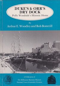
Book, Arthur E. Woodley et al, Duke’s & Orr’s Dry Dock, Polly Woodside’s Historic Home, 1985
... polly woodside national trust yarra river south wharf interest ...70 pages : illustrations, facsimiles, mapsnon-fictionduke and orr dry dock, polly woodside, national trust, yarra river, south wharf, interest group -
 Greensborough Historical Society
Book, Nillumbik Shire Council, 1997 Community Guide Nillumbik, 1997_
... and the southern boundary is the Yarra River. The south of Nillumbik... north-east of Melbourne and the southern boundary is the Yarra ...Guide to services provided by Nillumbik Shire Council. Nillumbik Shire is located 25 kilometres north-east of Melbourne and the southern boundary is the Yarra River. The south of Nillumbik is predominantly urban, with commercial centres at Eltham and Diamond Creek. The north of the municipality includes significant natural features like Kinglake National Park and Sugarloaf ReservoirAnnual guide to services in Nillumbik. 64 pages. Cover is pale yellow with colour drawings. nillumbik shire council, handbooks -
 Greensborough Historical Society
Book, Nillumbik Shire Council, 1998 Community Guide Nillumbik, 1998_
... and the southern boundary is the Yarra River. The south of Nillumbik... north-east of Melbourne and the southern boundary is the Yarra ...Guide to services provided by Nillumbik Shire Council. Nillumbik Shire is located 25 kilometres north-east of Melbourne and the southern boundary is the Yarra River. The south of Nillumbik is predominantly urban, with commercial centres at Eltham and Diamond Creek. The north of the municipality includes significant natural features like Kinglake National Park and Sugarloaf ReservoirAnnual guide to services in Nillumbik 72 pages. Cover has white background and some 3-D artwork.nillumbik shire council, handbooks -
 Greensborough Historical Society
Book, Nillumbik Shire Council, 1999 Community Guide Nillumbik, 1999_
... and the southern boundary is the Yarra River. The south of Nillumbik... north-east of Melbourne and the southern boundary is the Yarra ...Guide to services provided by Nillumbik Shire Council. Nillumbik Shire is located 25 kilometres north-east of Melbourne and the southern boundary is the Yarra River. The south of Nillumbik is predominantly urban, with commercial centres at Eltham and Diamond Creek. The north of the municipality includes significant natural features like Kinglake National Park and Sugarloaf ReservoirAnnual guide to services in Nillumbik76 pages, illus. Cover has photographs of local people and title in white on orange background.nillumbik shire council, handbooks -
 Greensborough Historical Society
Book, Nillumbik Shire Council, Nillumbik Community Guide 2000/2001, 2000-2001
... and the southern boundary is the Yarra River. The south of Nillumbik... north-east of Melbourne and the southern boundary is the Yarra ...Guide to services provided by Nillumbik Shire Council. Nillumbik Shire is located 25 kilometres north-east of Melbourne and the southern boundary is the Yarra River. The south of Nillumbik is predominantly urban, with commercial centres at Eltham and Diamond Creek. The north of the municipality includes significant natural features like Kinglake National Park and Sugarloaf ReservoirAnnual guide to services in Nillumbik76 pages, black and white illustrations. Cover has a collage of local children with title in white on mid-blue background.nillumbik shire council, handbooks -
 Greensborough Historical Society
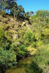
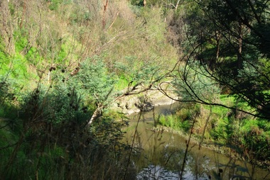
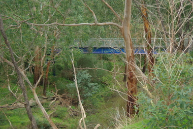
Photograph - Digital Image, Plenty River Greensborough, May 2014 -10, 21/05/2014
The Plenty River flows south from Mt Disappointment before meeting with the Yarra River at Rosanna. Early settlement in Greensborough was based around the Plenty River. These images were taken in the Greensborough area by Marilyn Smith May 2014.Digital copy of colour photograph.plenty river -
 Greensborough Historical Society
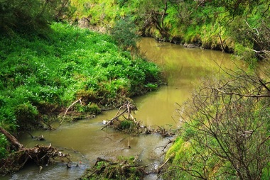
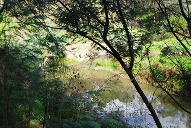
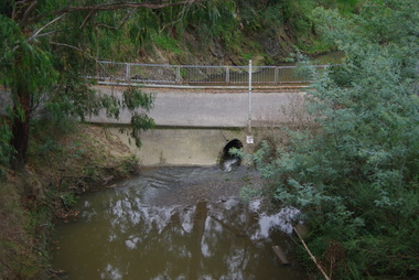
Photograph - Digital Image, Plenty River Greensborough, May 2014 -9, 21/05/2014
The Plenty River flows south from Mt Disappointment before meeting with the Yarra River at Rosanna. Early settlement in Greensborough was based around the Plenty River. These images were taken in the Greensborough area by Marilyn Smith May 2014.Digital copy of colour photograph.plenty river -
 Greensborough Historical Society
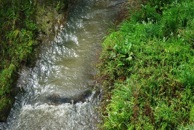
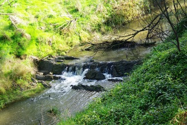
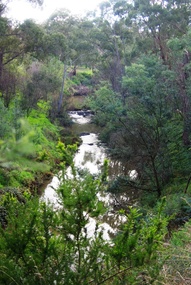
Photograph - Digital Image, Plenty River Greensborough, May 2014 -8, 18/09/2014
The Plenty River flows south from Mt Disappointment before meeting with the Yarra River at Rosanna. Early settlement in Greensborough was based around the Plenty River. These images were taken in the Greensborough area by Marilyn Smith Sept 2014.Digital copy of colour photograph.plenty river -
 Greensborough Historical Society
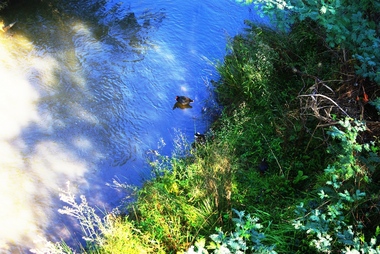
Photograph - Digital Image, Plenty River Greensborough, May 2014 -7, 21/05/2014
The Plenty River flows south from Mt Disappointment before meeting with the Yarra River at Rosanna. Early settlement in Greensborough was based around the Plenty River. These images were taken in the Greensborough area by Marilyn Smith May 2014.Digital copy of colour photograph.plenty river -
 Greensborough Historical Society
Photograph - Digital Image, Plenty River Greensborough, May 2014 -6, 21/05/2014
The Plenty River flows south from Mt Disappointment before meeting with the Yarra River at Rosanna. Early settlement in Greensborough was based around the Plenty River. These images were taken in the Greensborough area by Marilyn Smith May 2014.Digital copy of colour photograph.plenty river -
 Greensborough Historical Society
Photograph - Digital Image, Plenty River Greensborough, May 2014 -5, 21/05/2014
The Plenty River flows south from Mt Disappointment before meeting with the Yarra River at Rosanna. Early settlement in Greensborough was based around the Plenty River. These images were taken in the Greensborough area by Marilyn Smith May 2014.Digital copy of colour photograph.plenty river -
 Greensborough Historical Society
Photograph - Digital Image, Plenty River Greensborough, May 2014 -4, 21/05/2014
The Plenty River flows south from Mt Disappointment before meeting with the Yarra River at Rosanna. Early settlement in Greensborough was based around the Plenty River. These images were taken in the Greensborough area by Marilyn Smith May 2014.Digital copy of colour photograph.plenty river -
 Greensborough Historical Society
Photograph - Digital Image, Plenty River Greensborough, May 2014 -3, 21/05/2014
The Plenty River flows south from Mt Disappointment before meeting with the Yarra River at Rosanna. Early settlement in Greensborough was based around the Plenty River. These images were taken in the Greensborough area by Marilyn Smith May 2014.Digital copy of colour photograph.plenty river -
 Greensborough Historical Society
Photograph - Digital Image, Plenty River Greensborough, May 2014 -2, 21/05/2014
The Plenty River flows south from Mt Disappointment before meeting with the Yarra River at Rosanna. Early settlement in Greensborough was based around the Plenty River. These images were taken in the Greensborough area by Marilyn Smith May 2014.Digital copy of colour photograph.plenty river -
 Greensborough Historical Society
Photograph - Digital Image, Plenty River Greensborough May 2014 -1, 21/05/2014
The Plenty River flows south from Mt Disappointment before meeting with the Yarra River at Rosanna. These images taken in the Greensborough area. Photograph by Marilyn Smith 2014.Digital copy of colour photograph.plenty river, greensborough -
 Greensborough Historical Society
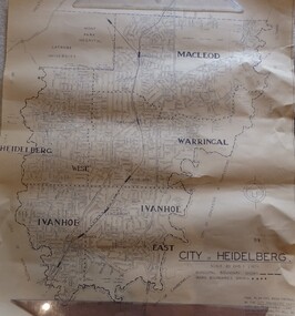
Map, City of Heidelberg. Engineers Dept, City of Heidelberg, 1960s
... Map of the City of Heidelberg from the Yarra River... the Yarra River in the South to North of Watsonia Military Camp ...Map of the City of Heidelberg from the Yarra River in the South to North of Watsonia Military Camp. Shire of Diamond Valley is shown to the north.Map showing municipal and ward boundaries, black text on light brown paper."Scale: 20 CHS = to 1 IN"city of heidelberg -
 City of Moorabbin Historical Society (Operating the Box Cottage Museum)
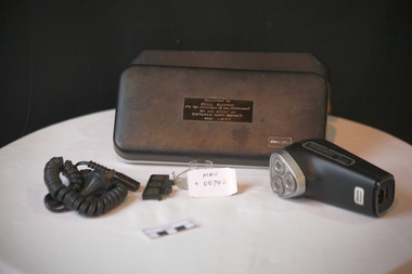
Personal Effects. 'Philips" electric Shaver, c1977
... , South Yarra, East St Kilda and moved to Bentleigh in 1987 ...Established in 1891 in Eindhoven, the Netherlands, Philips & Co. was founded to meet the growing demand for light bulbs following the commercialization of electricity. Science and technology underwent tremendous development in the 1940s and 1950s, with Philips Research inventing the rotary heads that led to the development of the Philishave electric shaver, and laying down the basis for later ground-breaking work in transistors and integrated circuits.Philishave was the brand name for the electric shavers manufactured by the Philips Domestic Appliances and Personal Care unit of Philips They used the Philishave brand name for their shavers from 1939 to 2006. The Philishave shaver was invented by Philips engineer Alexandre Horowitz, who used rotating cutters instead of the reciprocating cutters that had been used in previous electric shavers. The shaver was introduced in 1939, though initial production was limited due to the outbreak of World War II. A more ergonomic egg-shaped single-head model was introduced in 1948 and was designed by US industrial designer Raymond Loewy. Global sales increased markedly after a double-head model was introduced in 1951. As a spin off from the light bulb and research is the dynamo-powered bicycle lamp. Its rotating power system inspires the Philishave triple head electric razor. A triple-head model was test marketed in Australia and New Zealand in 1956, but would not be introduced globally until 1966. The brand name Philishave was phased out in 2006 so shavers now bear only the Philips name. Mr Alfred William ( Bill ) Roper, 1913 - 1996 grew up in Ripponlea, ( East St Kilda ) Victoria. As a child he went with his father Arthur Leopold Roper to purchase vegetables from the Moorabbin Chinese market gardeners at the Hotham St. / Nepean Highway corner. c1920 . Bill served in WW2 in New Guinea and post war was Army Auditor, Victoria Barracks, St Kilda Road Melbourne. His staff presented this 'Philishave upon his retirement and he used it until his death1996. He lived in Carlton, Belgrave, Ascot Vale, South Yarra, East St Kilda and moved to Bentleigh in 1987.A ‘Philishave’ triple head electric razor , with cord, head protector and cleaning brush in a hinged plastic case The case has compartments, for Razor and cord, that are lined with a mustard coloured, soft, synthetic material .Case top PHILIPS ; inside EXCLUSIVE PHILISHAVE Razor Handle front PHILIPS / PHILISHAVE; back Type HP 1121/ 110-130V/ 220-240 V / PHILIPS Shield / ? Shield / BS 3456 / V 75255 / MADE IN HOLLAND Nameplate Presented to / BILL ROPER / On the occasion of his retirement / BY THE STAFF OF / DEFENCE AUDIT BRANCH / May 1977 philishave, royal philips electric company, razors, electric razors, bentleigh, moorabbin, market gardeners, st kilda markets, world war 2 1939-1945, department of defence melbourne, melbourne, roper alfred william, roper arthur leopold, ripponlea, chinese market gardeners -
 Greensborough Historical Society
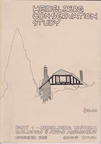
Book, Heidelberg Conservation Study: Part 1 Historic Buildings and Areas Assessment, 1985_
Report prepared by Graeme Butler on behalf of City of Heidelberg and Heidelberg Heritage Advisory Committee. Area covered is from Eaglemont in the south to Macleod in the north.This study identifies neighbourhood character, documents past development and the capacity of the environment for future development.Part one of set of three books. Paperback, 189 pages, Illus., maps. 2 copies.Stamps: Yarra Plenty Regional Library Service, and, Withdrawnheidelberg, macleod, heidelberg heritage advisory committee, graeme butler, plenty river, eaglemont -
 Greensborough Historical Society
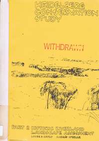
Book, Heidelberg Conservation Study: Part 2: Historic Riverland Landscape Assessment. Revised 1987, 1987_
Report prepared by Loder and Bayly and Marilyn McBriar on behalf of City of Heidelberg and Heidelberg Heritage Advisory Committee. Area covered is from Darebin Parklands in the south to Plenty River at Yallambie in the north. Revised 1987.This study identifies neighbourhood character, documents past development and the capacity of the environment for future development with particular emphasis on the river precincts - Plenty River, Yarra River and Darebin Creek.Part three of set of three books. Paperback, 333 pages, Illus., maps. 2 copies.Stamps: Yarra Plenty Regional Library Service, and, Withdrawnheidelberg, macleod, heidelberg heritage advisory committee, marilyn mcbriar, plenty river, yarra river, darebin creek -
 Eltham District Historical Society Inc
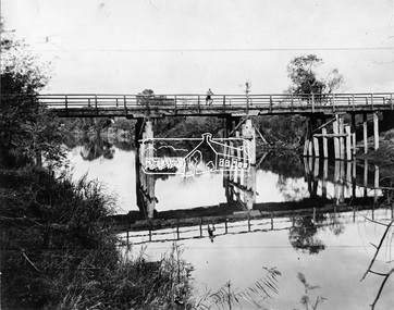
Negative - Photograph, Henley Bridge, c.1928
... Situated on the Yarra River, 5.5 kms south of Christmas... melbourne Situated on the Yarra River, 5.5 kms south of Christmas ...Situated on the Yarra River, 5.5 kms south of Christmas Hills on private property. This timber trestle bridge is said to have been built some time after 1907 by Melbourne master-builder, David Mitchell (the father of Dame Nellie Melba), to connect his two "Henley Farm" properties with Lilydale. In earlier days, when the McPhersons owned the property, their children used a punt to cross the river to attend Yering Primary School. This private bridge is best viewed from the end of Wendy Way. - Source: Christmas Hills Past and Present, Yarra Glen & District Historical Society, 2004.This photo forms part of a collection of photographs gathered by the Shire of Eltham for their centenary project book,"Pioneers and Painters: 100 years of the Shire of Eltham" by Alan Marshall (1971). The collection of over 500 images is held in partnership between Eltham District Historical Society and Yarra Plenty Regional Library (Eltham Library) and is now formally known as the 'The Shire of Eltham Pioneers Photograph Collection.' It is significant in being the first community sourced collection representing the places and people of the Shire's first one hundred years.Digital image 4 x 5 inch black and white negative 9 x 12.5 cm printshire of eltham pioneers photograph collection, warrandyte, henley bridge, reflection -
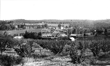 Eltham District Historical Society Inc
Photograph, Research. Main Road left to right showing school on left top. View from Orchard. Ref. 511 looking south-south west
Source: Mrs. E.R. Reynolds, Thompson Crescent, ResearchThis photo forms part of a collection of photographs gathered by the Shire of Eltham for their centenary project book,"Pioneers and Painters: 100 years of the Shire of Eltham" by Alan Marshall (1971). The collection of over 500 images is held in partnership between Eltham District Historical Society and Yarra Plenty Regional Library (Eltham Library) and is now formally known as the 'The Shire of Eltham Pioneers Photograph Collection.' It is significant in being the first community sourced collection representing the places and people of the Shire's first one hundred years.Digital imagesepp, shire of eltham pioneers photograph collection, research (vic.) -
 Eltham District Historical Society Inc
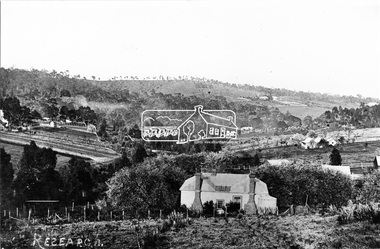
Photograph, Research, Vic
Research. House in centre foreground is same house as centre left Ref. 512. Looking about south-south west, down Research Gully Road. Source: Mrs. E.R. Reynolds, Thompson Crescent, ResearchThis photo forms part of a collection of photographs gathered by the Shire of Eltham for their centenary project book,"Pioneers and Painters: 100 years of the Shire of Eltham" by Alan Marshall (1971). The collection of over 500 images is held in partnership between Eltham District Historical Society and Yarra Plenty Regional Library (Eltham Library) and is now formally known as the 'The Shire of Eltham Pioneers Photograph Collection.' It is significant in being the first community sourced collection representing the places and people of the Shire's first one hundred years.Digital imagesepp, shire of eltham pioneers photograph collection, research (vic.) -
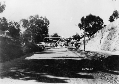 Eltham District Historical Society Inc
Negative - Photograph, J.H. Clark, Main Road, Eltham, c.1908
Gahan house on left, bakery on right at corner of York Street, Shillinglaw Cottage in distance. Newly constructed footpath (refer SEPP_0616) on eastern side between York Street and Bridge Street. Photo by J.H. Clark - John Henry Clark was one of four brothers that ran a photography business, Clark Bros. from 25 Thomas Street, Windsor between c.1894 and 1914. Source: Mr. L. Jarrold, Dromana, (formerly Eltham) Photographer: J.H. Clark John Henry Clark was the youngest of three boys born to William Henry Clark (1823-1877) and Maria White (1843-1914). He and his brothers, William Charles Clark (1872-1945), Clement Kent Clark (1874-1912) operated a photography business (Clark Bros.) from 25 Thomas Street, Windsor near Prahran during the period c.1894 to 1914. Following death of Clement in September 1912 and their mother in 1914, the Clark Bros business appears to have dissolved, the premises demolished, and a new house was under construction in 1915. John set up business independently in 1914 operating out of 29 Moor Street, Fitzroy where he is registered in the 1914 and 1915 Electoral Rolls. By 1916 John had relocated to Eltham where he continued his practice as a photographer and took many of the early images around the district of Little Eltham. Around 1930 John changed professions and opened a small cobbler's shop in 1931 near the pond opposite Dalton Street adjacent to the Jarrold family cottage. He never married and continued his profession as a bootmaker from this little shop, maintaining a close relationship with Mrs Jarrold for the rest of their lives. His bootmaker shop remains today beside the Whitecloud cottage and is one of only three remaining shops in the area from the early 20th century. There are a couple of images of Eltham taken by Clark Bros. in the Eltham District Historical Society collection, one such example being Hunniford’s Post Office with Miss Anne Hunniford out front (EDHS_00140 - marked on the back of the print, Clark Bros., 25 Thomas St. Windsor), which would date this image between c.1894 and 1914. Other early images of Eltham taken by John Henry Clark are marked on the face “J. H. Clark Photo” and it is assumed these are dated between 1914 and 1930. It is noted that the Grant of Probate for John H Clark of Eltham South dated 5 April !957 (513/387) records his occupation as "X Photographer".This photo forms part of a collection of photographs gathered by the Shire of Eltham for their centenary project book,"Pioneers and Painters: 100 years of the Shire of Eltham" by Alan Marshall (1971). The collection of over 500 images is held in partnership between Eltham District Historical Society and Yarra Plenty Regional Library (Eltham Library) and is now formally known as the 'The Shire of Eltham Pioneers Photograph Collection.' It is significant in being the first community sourced collection representing the places and people of the Shire's first one hundred years.Digital image 4 x 5 inch B&W NegJ.H. Clark Photoshire of eltham pioneers photograph collection, eltham, main road, gahan house, bakery, bridge street, footpath, j.h. clark photo, shillinglaw cottage, shillinglaw trees, york street -
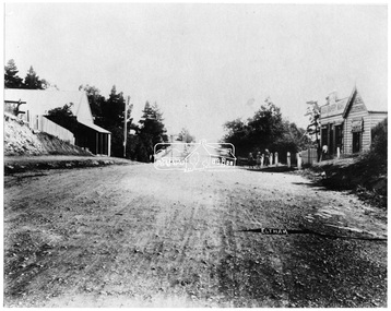 Eltham District Historical Society Inc
Negative - Photograph, Main Road, Eltham, looking south from Bridge Street, 1906-1907
Looking south along Main Road from the south side of the intersection of Bridge Street with Main Road. Anne Hunniford's Post Office and Burgoyne's store on left. Miss Harriet (Minnie) Williams's Cash Drapery Mart (est. 1902 and enlarged in 1906), also known as Eltham House on the right. Harriet (Minnie) Williams was born London, 1857, the daughter of George John Williams (1812-1895) and Jane Mansfield (1812-1895). In September 1885 she was operating Williams’s Drapery Establishment in premises on Main Road owned by R. Wallis who advertised them to let in September 1885. In 1902 she opened Williams’s Cash Drapery Mart at the southwest corner of Bridge Street and Main Road (opposite the Post Office), owned by W.J. Taylor. In 1906 she bought the premises and one quarter acre of land and expanded the business with a re-opening in April 1906. Harriet was also well-known and esteemed as an active worker in Methodist circles and also Superintendent of the Sunday School. Harriet fell ill in August 1907 and died 15 August. She is buried in Eltham Cemetery with her good friend Ada Ford. Evelyn Observer and Bourke East Record (Vic. : 1902 - 1917), Friday 30 March 1906, page 5 ________________________________________ ELTHAM. (FROM OUR OWN CORRESPONDENT.) For over three years Miss Williams has carried on a drapery business in very small and inconvenient premises opposite the Eltham post-office. Recently she bought the building and a quarter-acre of land from Mr. W. J. Taylor. Thus having a free hand, she at once matured plans to enlarge and improve the premises to make them suitable for her growing business. The result being that she consulted Mr Roach, contractor, of Heidelberg, put the matter in his hands, and now he has completed in a very satisfactory manner and up-to-date style extensive improvements. A large addition, of very neat and attractive design, with three large windows, has been built right along the front of the old building, and the counters and inside fittings are very neat and convenient, harmonizing well with the attractive outside appearance. Miss Williams has now got in a large now stock of goods, and is making extensive arrangements for a “reopening week," commencing 2nd April, during which time she will make 10 per cent reduction on all cash purchases in the form of gifts of that value. Miss Williams has gone to considerable expense and liability both, in the enlargement and improvement of the premises and in purchasing additional stock. We therefore trust that the public will stand by her by heartily and en masse patronizing her re-opening effort to show their appreciation of pluck in this advance movement. Google Street View Feb 2017: https://www.google.com.au/maps/@-37.7191341,145.1462046,3a,50.5y,191.91h,88.27t/data=!3m6!1e1!3m4!1sARwwqEQfMSfH9oTWWapPgQ!2e0!7i13312!8i6656This photo forms part of a collection of photographs gathered by the Shire of Eltham for their centenary project book,"Pioneers and Painters: 100 years of the Shire of Eltham" by Alan Marshall (1971). The collection of over 500 images is held in partnership between Eltham District Historical Society and Yarra Plenty Regional Library (Eltham Library) and is now formally known as the 'The Shire of Eltham Pioneers Photograph Collection.' It is significant in being the first community sourced collection representing the places and people of the Shire's first one hundred years.Digital image 4 x 5 inch B&W Negsepp, shire of eltham pioneers photograph collection, eltham, main road, anne jane hunniford, burgoyne store, christopher watson, commercial bank of australia, drapery store, eltham house, harriet (minnie) williams, post office, watson's hotel, williams's cash drapery mart -
 Eltham District Historical Society Inc
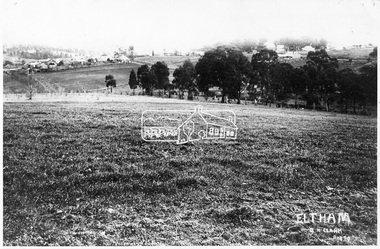
Negative - Photograph, J.H. Clark, View of Little Eltham, c.1913
View looking northwest towards the main road (Maria Street) and the village of Little Eltham, c.1913 (from near present day 9 Bible Street) Photographer: J.H. Clark John Henry Clark was the youngest of three boys born to William Henry Clark (1823-1877) and Maria White (1843-1914). He and his brothers, William Charles Clark (1872-1945), Clement Kent Clark (1874-1912) operated a photography business (Clark Bros.) from 25 Thomas Street, Windsor near Prahran during the period c.1894 to 1914. Following death of Clement in September 1912 and their mother in 1914, the Clark Bros business appears to have dissolved, the premises demolished, and a new house was under construction in 1915. John set up business independently in 1914 operating out of 29 Moor Street, Fitzroy where he is registered in the 1914 and 1915 Electoral Rolls. By 1916 John had relocated to Eltham where he continued his practice as a photographer and took many of the early images around the district of Little Eltham. Around 1930 John changed professions and opened a small cobbler's shop in 1931 near the pond opposite Dalton Street adjacent to the Jarrold family cottage. He never married and continued his profession as a bootmaker from this little shop, maintaining a close relationship with Mrs Jarrold for the rest of their lives. His bootmaker shop remains today beside the Whitecloud cottage and is one of only three remaining shops in the area from the early 20th century. There are a couple of images of Eltham taken by Clark Bros. in the Eltham District Historical Society collection, one such example being Hunniford’s Post Office with Miss Anne Hunniford out front (EDHS_00140 - marked on the back of the print, Clark Bros., 25 Thomas St. Windsor), which would date this image between c.1894 and 1914. Other early images of Eltham taken by John Henry Clark are marked on the face “J. H. Clark Photo” and it is assumed these are dated between 1914 and 1930. It is noted that the Grant of Probate for John H Clark of Eltham South dated 5 April !957 (513/387) records his occupation as "X Photographer".This photo forms part of a collection of photographs gathered by the Shire of Eltham for their centenary project book,"Pioneers and Painters: 100 years of the Shire of Eltham" by Alan Marshall (1971). The collection of over 500 images is held in partnership between Eltham District Historical Society and Yarra Plenty Regional Library (Eltham Library) and is now formally known as the 'The Shire of Eltham Pioneers Photograph Collection.' It is significant in being the first community sourced collection representing the places and people of the Shire's first one hundred years.Digital image 4 x 5 inch B&W Negsepp, shire of eltham pioneers photograph collection, eltham, main road, court house, police station, pitt street, eltham hotel, evelyn hotel, fountain hotel, fountain of friendship hotel, j.h. clark photo, knapmans forge, lock-up, police residence, police stables, st margaret's church