Showing 822 items matching "supplies"
-
 Kiewa Valley Historical Society
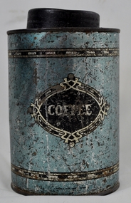
Tin Coffee Cylindrical, circa mid to late 1900's
This "coffee" tin has by the "art deco" appearance its origins in the late 1950's to 1960's. This time period was one of accelerated growth both in the physical (housing) sense and the mental (new ideas and inventions) changes in "attitudes". These occurred more rapidly in cities but had its effects on the rural environment. The drinking of coffee was spurred on by easier distribution of imported food and drinks. Advertising by stronger radio links and then by television brought the variety of foods and drinks to semi isolated rural regions. The accessibility through greater information channels becoming available brought with it unbelievable ranges of goods and foodstuffs. Rural regions still relied on bulk supplies and relatively larger storage containers than those in cities. This "bulk" buying and storage "syndrome" was a lingering result of many years of "drought" periods when road transports met delays from flooded roadways in supplying population centres in the Kiewa Valley. The construction phases in building the SEC Vic Hydro electricity Scheme in the eastern sections of the Victorian Alps brought many changes to the quiet rural regions in the Kiewa Valley. Changes in population and social mores. The influx of a varied , mostly temporary, and "European flavoured cuisine" changes the "cuppa tea only" flavour to the have a "coffee break". The subliminal influence of the "American" films changed those children growing up in the post 1950s from the "English tea" to the "American coffee". This "Americanisation process has influenced not only rural Australia but also other areas throughout the world.This "insignificant" coffee tin is very significant as it demonstrates that the Kiewa Valley was becoming more accessible to reliable coffee supplies and general food items.The container was part of a "set" of containers that included tea, sugar,biscuits,flour, rice and other family condiments. This type of kitchen storage containers was brought about through changing patterns in tea and coffee useage and overall consumption. Household demands for faster "self help" cooking especially beveridges and the greater choice of kitchen "utensils" was brought on by easier access to products due to a lessening of the area's "isolation" by having a reliable (all weather) road system and an ever increasing population growth. The need for travelling goods/merchant supply caravans to service the area became a diminishing factor, as a result of the establishment of grocery stores in Tawonga and Mount Beauty in the supply of previously "hard to get" groceries. This transition was precipitated by the SEC Vic Hydro Scheme of the 1940's to 1960's which increased the valley's population level three fold.This cylindrical tin has a pull/push lid(for easy access to the contents). The container is labelled for "coffee" however it has no commercial manufacturer's label to establish that it was bought with coffee ingredients in it. The majority of the container's external surface has a "metallic" light blue colour with two sets of silver rings confining black (horizontal spotted) rectangles. "COFFEE" within an elongated spherical "art deco" four pointed banner of silver and black colouringkitchen containers, domestic food storage, bulk stocks of dried condiments -
 Wodonga & District Historical Society Inc
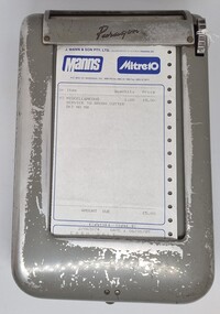
Functional object - Business Docket Dispenser, Lamson Paragon, c1960s
J. Mann and Sons was first established as a farm produce store in 1921. The range of products was extended in the 1930s and included groceries and hardware, as well as the first petrol bowser in Wodonga outside the store. After WWII, the premises were extended and the range of products continued to increase. In the 1960s the Mann Family opened a new supermarket in Wodonga, in addition to the hardware business, providing steel, plumbing and industrial supplies, and they employed over 100 people at one stage. With changes in the retail industry, the Mann Family sold the main hardware business to Bunnings and the steel and rural produce business to the Kelly brothers in 2006. Paragon, trading at various times as Lancom Paragon, Moore Paragon, Paragon Printing and the South Pacific Print Group, was also based in Wodonga from 1958 until 2010. It began as Lamson Paragon in 1958 but was destroyed by a fire causing £150,000 damage. The factory resumed operations on 24 June 1959.with 30 staff and by 1973 employed 120 and used 80 tons of paper per week. Further develp[ment took place to the factory in 2 stages. In 1977 Moore Corporation of Toronto took over control of the London based parent company Lamson Paragon necessitating a change of name of the Australian company to become Moore Business Systems Australia Limited. After many successful years of operation including expansion to a staff of 240 people, changes to business operations and the loss of several large contracts led to the company entering voluntary administration in March 2010.This machine and docket has local provenance as it came from the 20th century business of J. Mann & Son in Wodonga..The machine was manufactured by Paragon, also operating as Lamcon Paragon and Moore Paragon, which were a major manufacturer in Wodonga from 1958 until 2010.This is a grey rectangular-shaped metal box with rounded edges. The box has four metal studs on the base to keep the box stable. The box has a hinged section to enable paper dockets to be inserted. It also has a turning mechanism for removing the dockets, one at a time from a slot at the top of the machine. The machine includes a docket from Mann Mitre 10 Wodonga operated by J. Mann & Son Pty. Ltd. The dockets provided a duplicate copy for the company as well as the white copy for the customer. The dispenser and dockets were produced by Paragon.At top of dispenser: "Paragon" Across top of docket: "J. MANN & SON Pty. Ltd. (Incorporated in Victoria) TRADING AS: / Manns Mitre 10/ P.O. BOX 141, VIC., 3690. Phone: (060) 24 4813paragon, lamson paragon, moore paragon, mann wodonga, moore business systems australia limited -
 Royal Brighton Yacht Club
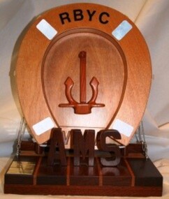
Life Ring, Vega Trophy (Mounted Wooden Life Ring)
Vega Trophy (Mounted Wooden Life Ring) Donor: Graham Noel During World War II when the Germans occupied the Channel Islands the local people went through very severe food rationing and were on the verge of starvation. Near the end of the war, the Swedish ship Vega was allowed by the Germans to deliver several shipments of food to the civilian population, easing the critical shortages of food on the islands. Further background detail can be found below. Graham Noel was born on the Islands and lived there during this harsh period. The trophy is awarded to the winner of the Combined Division AMS Aggregate Series. First Winner: Under Capricorn, P. Bedlington 2005/06 Vega – Further historical background Early in the Second World War Jersey was declared “unarmed” and the German military took over, taking quite a few lives in the process, through strafing the main harbour and a few other places which they needlessly considered threatening. A considerable number of locals evacuated to England before the Germans arrived, but more than 60% of the population remained and endured 5 years of very strict and difficult conditions. Not only was the population unable to contact relatives in the UK or elsewhere, but very quickly they found themselves subject to harsh curfews, strictly rationed foodstuffs, no fuel for vehicles, radios confiscated, and homes and hotels commandeered by the military. The military demanded first pick of all foodstuffs and kept meticulous records of all livestock forcing farmers even to show newborn calves and piglets to them, then claiming the new arrivals for their dinner tables. However there are many stories of farmers outwitting their masters when twin calves or suchlike arrived! Lawbreakers were quickly dealt with, mostly with lengthy prison terms in Jersey, but the more serious crimes were punished by being sent to some horrible French prisons, or even some of the notorious German concentration camps. All local Jews were dispatched to concentration camps, and even English born families were similarly shipped through France and on to Germany. Sadly, a considerable number of those deported did not make it back safely to Jersey. In June 1944 the locals were delighted to hear that the Allies had invaded Normandy and very soon they could hear the battles as the Allies worked their way along the French coast. Little did they know they would still have to wait another 11 months for freedom, having to put up with a very demanding German occupation force which was still determined to obey Hitler’s order to “Defend the Channel Islands to the death”. Now that France was in Allied Hands the local military commanders were unable to supplement their food supplies from France and even harsher demands were made on the local population to ensure that all branches of their still very substantial military force were reasonably well fed. As well as the military, Jersey farmers had to provide food for the Allied POWs and the many “forced labourers”, mainly of Russian, Polish and Italian backgrounds who had been directed to the island to build all the concrete bunkers. This included an underground hospital, all this complying with Hitler’s orders to ensure that the Channel Islands would never again be part of Britain. Many requests by the Jersey authorities for Red Cross assistance were rejected, but finally in December 1944 they agreed and on 30th December the Red Cross vessel “Vega” (Swedish Registry) arrived and delivered parcels to the civilian population. These parcels contained a variety of foodstuffs supplied mainly by Canadian authorities, desperately needed medical supplies, flour, oils and soaps, as well as tobacco from New Zealand. Vega made a further 3 or 4 trips and most certainly eased the desperate situation being faced by the locals. In fact, it resulted in the locals having slightly better food supplies than the military and many local farmers tell stories of having to protect their stock from marauding soldiers. Understandably Churchill was reluctant to send in an invading force to retake the Channel Islands, but by May 1945 it was clear that the Third Reich was finished and on May 9th the German Military surrendered, without a fight, to a large British landing force. On a slightly lighter note … in January 1945 Jersey stonemasons were seen in the main town square repairing flagstones … the Germans had never noticed that the name “Vega” had been formed in those flagstones! As a side note Vega is the name of the brightest star in the universe. Furthermore, throughout the occupation, despite German law that demanded confiscation of all radio sets, punishable by long prison terms or deportation to Germany, there were still many sets being listened to. The locals had a well refined news system for the dissemination of news of what was happening in the outside world. vega, graham noel, ams, combined division, aggregate -
 Red Cliffs Military Museum
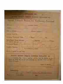
Certificate, Special Tabacco Ration for Ex-Service personnel, 1945 (estimated)
Part of a collection for Thomas Henry Anderson VX 34767Consummers copy of rationing certificate for tabacco to Ex-Service personnelConsumer's Copy/ National Security (Tabacco Rationing) Regulations 1942/ Specil Tabacco Ration for Ex-Service personnel/ Surname Anderson Christian Names: Thomas Henry/ Address: P.O. Red Cliffs/ Male or Female/ Service Number: VX 34767/ Identity Card No/ R(unreadable) No./ Monthly Quota Selected- Cigarettes... 8oz Tabacco/ see details on other side/Nominated Retailer x Stracos..(Unreadable)..P/L/ John..L (unreadable) & Co/ (to be filled in bt retailer)/ Quota to operate on and from ....../ National Security (Tabacco Rationing) Regulations 1942/ I declare that I am a genuine smoker, that all supplies to be/ drawn as above are for my own personal use/ and that I have no other source of supply./ ...... signature of Applicant/ c.812/9.45-c.5491/ Authorized by (faded Signature)/ Chairman, Tabacco Distribution Committee/ Place Melle Ror Date: 20 Feb 1946 (More details on back of sheet but it is glused to a board)discharge, thomas, 1942, anderson, tabacco, rationing, henry, cigarettes, regulations, nation, security -
 Coal Creek Community Park & Museum
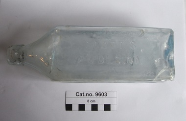
Bottle, glass, Bottle with these contents c. 1898 - 1920
TROVE : Herald (Melbourne, Vic. : 1861 - 1954), Friday 31 October 1884, page 4 J SCOTT'S EMULSION 0F1 PURE COD LIVER OIL And HYPOPHOSPHITES of LIME and SODA. , Almost as PALATABLE as MILK. Possessing the combined virtues of these two valuable remedics in their fullest degree More easily digested and assimilated than in the crude form, and especially desirable for sickly, wasting children, and persons with feeble digestive power, as A REMEDY for CONSUMPTION, A REMEDY for WASTING DISEASES of CHILDREN, A REMEDY for SCROFULA, A REMEDY for ANAEMIA and GENERAL DEBILITY, A REMEDY for COUGHS, COLDS, and THROAT AFFECTIONS; In fact all diseases where there is an inflammation of the Throat and Lungs, a Wasting of the Flesh, and a Want of Nerve Power, nothing in the world equals this palatable EMULSION. lt is prescribed and endorsed by the best physicians in the various countries of the world, who will attest these facts. For sale by all chemists. TROVE : Age (Melbourne, Vic. : 1854 - 1954), Tuesday 11 September 1951, page 5 WARNING TO PARENTS Build your family's resistance to colds and 'flu with Scott's Coughs and colds undermine a child's health. and lay him wide open to disease. You can't protect youngster against exposure to colds, but you can build their resistance with a course of Scott's Emulsion. Scott's Emulsion supplies just the elements a child need to ensures straight, sturdy body, strong bones, steady nerves and sound lungs. It is a dependable safeguard against colds and coughs. It's just as good for all the family, , For babies under 12 months old give SCOTT'S CLINIC EMULSION without Hypophosphites Scott's Emulsion NATURE'S OWN FOOD TONIC. SE34 Tall clear aqua tinted glass bottle for stopper seal, rectangular in section, impressed panels on three sides, circle impressed on base, text embossed on all.Front : 'SCOTT'S EMULSION', Sides : COD LIVER OIL', 'WITH LIME & SODA'. Base : '1367', 'K', 'B & Co LTD'.cod liver oil, lime & soda, knottingley, scott & browne, scotts emulsion -
 8th/13th Victorian Mounted Rifles Regimental Collection
Photograph
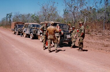
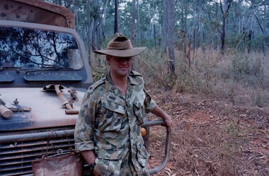
The Dibb Report into mainland defence of Australia,1986, among other things identified the requirement for protection of key assets in Northern Australia and the possibility of involving Army Reserve (Ares) units in this thus releasing regular forces for offensive operations. Dibb also pointed out that this defined role would result in a huge lift in Ares morale. In June 1988, the 3rd Division (3Div) conducted a Tactical Exercise without Troops (TEWT), Exercise ‘Distant Trumpet’ in the Katherine- Darwin area to study problems associated with defence against low level incursions against Tindal RAAF Base. Exercise ‘Northern Explorer’ followed in October of that year when units of the 3Div including A Squadron 8/13 Victorian Mounted Rifles sent patrol groups to get a first taste of environment and conditions. Post-Exercise reports had to include recommendations re: health, equipment and adaptation of Standing Operating Procedures (SOPs) in preparation for the new role deploying to Northern Australia. The first deployment by 8/13 Victorian Mounted Rifles was in 1988. Deployments continued in following years. In September 1993, 3 Troop (Wangaratta) VMR Squadron 4/19 PWLH commanded by Captain Kelvin Robertson deployed to NT. The training began with airfield defence at Tindal followed by a 1000km recon into Arnhem Land in four Landrovers. The troop reported on the conditions of the roads, airfields, bridges (mainly causeways) resources such as fuel supplies in the towns and infrastructure. Each troop taking different route. 3 Troop had the Northern route through Kakadu National park across the East Alligator River to Oenpelli then to Maningrida and Ramangining and south to the Central Arnhem Road and back to Tindal Air force Base. Colour photograph of five soldiers and three vehicles of VMR Squadron,4/19 Prince of Wales's Light Horse on roadside during annual exercise in Northern Territory 1994.military, vehicles, soldiers, northern territory, training, vmr -
 8th/13th Victorian Mounted Rifles Regimental Collection
Photograph
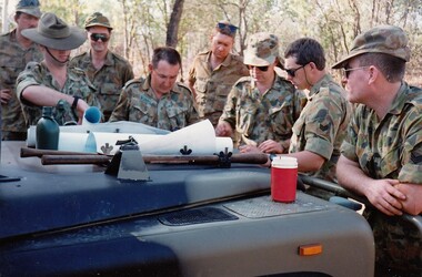
The Dibb Report into mainland defence of Australia,1986, among other things identified the requirement for protection of key assets in Northern Australia and the possibility of involving Army Reserve (Ares) units in this thus releasing regular forces for offensive operations. Dibb also pointed out that this defined role would result in a huge lift in Ares morale. In June 1988, the 3rd Division (3Div) conducted a Tactical Exercise without Troops (TEWT), Exercise ‘Distant Trumpet’ in the Katherine- Darwin area to study problems associated with defence against low level incursions against Tindal RAAF Base. Exercise ‘Northern Explorer’ followed in October of that year when units of the 3Div including A Squadron 8/13 Victorian Mounted Rifles sent patrol groups to get a first taste of environment and conditions. Post-Exercise reports had to include recommendations re: health, equipment and adaptation of Standing Operating Procedures (SOPs) in preparation for the new role deploying to Northern Australia. The first deployment by 8/13 Victorian Mounted Rifles was in 1988. Deployments continued in following years. In September 1993, 3 Troop (Wangaratta) VMR Squadron 4/19 PWLH commanded by Captain Kelvin Robertson deployed to NT. The training began with airfield defence at Tindal followed by a 1000km recon into Arnhem Land in four Landrovers. The troop reported on the conditions of the roads, airfields, bridges (mainly causeways) resources such as fuel supplies in the towns and infrastructure. Each troop taking different route. 3 Troop had the Northern route through Kakadu National park across the East Alligator River to Oenpelli then to Maningrida and Ramangining and south to the Central Arnhem Road and back to Tindal Air force Base. Colour photograph of group of soldiers of VMR Squadron 4/19Prince of Wales's Light Horse studying maps on bonnet of Land Rover during annual exercise in Northern Territory 1994.Major M. Annett wearing slouch hat, Sergeant Gary Wynn,without hat,,on his left. -
 8th/13th Victorian Mounted Rifles Regimental Collection
Photograph
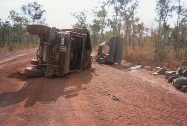
The Dibb Report into mainland defence of Australia,1986, among other things identified the requirement for protection of key assets in Northern Australia and the possibility of involving Army Reserve (Ares) units in this thus releasing regular forces for offensive operations. Dibb also pointed out that this defined role would result in a huge lift in Ares morale. In June 1988, the 3rd Division (3Div) conducted a Tactical Exercise without Troops (TEWT), Exercise ‘Distant Trumpet’ in the Katherine- Darwin area to study problems associated with defence against low level incursions against Tindal RAAF Base. Exercise ‘Northern Explorer’ followed in October of that year when units of the 3Div including A Squadron 8/13 Victorian Mounted Rifles sent patrol groups to get a first taste of environment and conditions. Post-Exercise reports had to include recommendations re: health, equipment and adaptation of Standing Operating Procedures (SOPs) in preparation for the new role deploying to Northern Australia. The first deployment by 8/13 Victorian Mounted Rifles was in 1988. Deployments continued in following years. In September 1993, 3 Troop (Wangaratta) VMR Squadron 4/19 PWLH commanded by Captain Kelvin Robertson deployed to NT. The training began with airfield defence at Tindal followed by a 1000km recon into Arnhem Land in four Landrovers. The troop reported on the conditions of the roads, airfields, bridges (mainly causeways) resources such as fuel supplies in the towns and infrastructure. Each troop taking different route. 3 Troop had the Northern route through Kakadu National park across the East Alligator River to Oenpelli then to Maningrida and Ramangining and south to the Central Arnhem Road and back to Tindal Air force Base. Two colour photographs of vehicle mishap during VMR Squadron 4/19Prince of Wales's Light Horse annual exercise in Northern Territory 1994.Second photo shows driver receiving medical attention. -
 8th/13th Victorian Mounted Rifles Regimental Collection
Photograph
The Dibb Report into mainland defence of Australia,1986, among other things identified the requirement for protection of key assets in Northern Australia and the possibility of involving Army Reserve (Ares) units in this thus releasing regular forces for offensive operations. Dibb also pointed out that this defined role would result in a huge lift in Ares morale. In June 1988, the 3rd Division (3Div) conducted a Tactical Exercise without Troops (TEWT), Exercise ‘Distant Trumpet’ in the Katherine- Darwin area to study problems associated with defence against low level incursions against Tindal RAAF Base. Exercise ‘Northern Explorer’ followed in October of that year when units of the 3Div including A Squadron 8/13 Victorian Mounted Rifles sent patrol groups to get a first taste of environment and conditions. Post-Exercise reports had to include recommendations re: health, equipment and adaptation of Standing Operating Procedures (SOPs) in preparation for the new role deploying to Northern Australia. The first deployment by 8/13 Victorian Mounted Rifles was in 1988. Deployments continued in following years. In September 1993, 3 Troop (Wangaratta) VMR Squadron 4/19 PWLH commanded by Captain Kelvin Robertson deployed to NT. The training began with airfield defence at Tindal followed by a 1000km recon into Arnhem Land in four Landrovers. The troop reported on the conditions of the roads, airfields, bridges (mainly causeways) resources such as fuel supplies in the towns and infrastructure. Each troop taking different route. 3 Troop had the Northern route through Kakadu National park across the East Alligator River to Oenpelli then to Maningrida and Ramangining and south to the Central Arnhem Road and back to Tindal Air force Base. Two colour photographs of creek crossings, one more challenging than the other,during the annual exercise in Northern Territory, conducted by VMR Squadron 4/19 Prince of Wales's Light horse, 1994. -
 Ballarat Tramway Museum
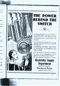
Document - Folder with papers, Robert Ashley, "Ballarat SEC History", 1989
Samizone flat file, made from manila card with blue printing for file details and a Dymo machine label on the spine (red background with white printing) titled "Ballarat SEC History". On inside of folder is a "Post It" note with handwriting "Robert Ashley Ex Employee" in blue ink. Contained within folder is" 1. "Ballarat, Electricity and the State Electricity Commission" photocopied from an original. Has typed under the heading over white out correction fluid "Notes - Draft notes prepared by Robert W. P. Ashley 1989." The paper gives the history of power supply in Ballarat, including street lighting, ESCo, AC and DC power supplies, the takeover by the SEC, Ballarat A and B power stations, a copy of an advertisement for the SEC in Ballarat. (See btm1701i3.jpg) titled "The Power Behind the Switch" 2. Paper by A. D. Senior, titled "Electricity Supply in Ballarat" - see Reg. Item No. 1700. (see btm1700i.pdf) 3. Photocopied onto foolscap paper of an extract from possibly a large report on power supply in Victoria. Pages 155 to 158. Reports on the history of the power supply system in Ballarat until the takeover of ESCo by the SEC. Further details are referred to another section of the Report on the SEC itself. On page 158 are details of Beaufort Council operated supply and the start of notes on Beechworth. (see btm1701i2.pdf) Images of files added 6-8-15 For an image of the advert itself see btm1701i3.pdfSee notes above.trams, tramways, secv, power supply, esco, beaufort -
 Bendigo Historical Society Inc.
Map - Laminated map of Lake Eppalock at full capacity
John Perry Collection. Laminated copy of map of Lake Eppalock at full capacity. Had highlighter markings of old roads which appear to be still in use. The dam was built by the State Rivers and Water Supply Commission of Victoria. The dam wall height is 45 metres (148 ft) and the main embankment is 1,041 metres (3,415 ft) long. At 100% capacity the dam wall was designed to hold back 304,651 megalitres (6.7014×10¹⁰ imp gal; 8.0480×10¹⁰ US gal) of water. The surface area of Lake Eppalock is 3,011 hectares (7,440 acres) and the catchment area is 2,124 square kilometres (820 sq mi). The controlled spillway is capable of discharging 8,040 cubic metres per second (284,000 cu ft/s). Lake Eppalock supplies both stock and domestic water to the Campaspe irrigation district. It also serves as a water supply to Bendigo and Heathcote and, in more recent times, Ballarat. The lake is a major attraction for those engaging in watersports, with a number of tourist parks and accommodation facilities available. Permissible activities on the lake include high-speed boating, water skiing, sailing, canoeing, fishing and swimming. The lake's water levels were low for approximately eight years between 2002 and 2010 during a prolonged drought, which restricted the amount of recreational activity until rainfall in the latter half of 2010 returned the lake to 100 percent capacity. Built between 1961 and 1964, Lake Eppalock remains the only water storage on the Campaspe River system.map, water, dam, reservoir, eppalock -
 Bendigo Historical Society Inc.
Map - Laminated worksheet - identification of inundated artifacts at Lake Eppalock
John Perry Collection. Laminated copy of worksheet identifying inundated artifacts at Lake Eppalock when at 10% capacity. The dam was built by the State Rivers and Water Supply Commission of Victoria. The dam wall height is 45 metres (148 ft) and the main embankment is 1,041 metres (3,415 ft) long. At 100% capacity the dam wall was designed to hold back 304,651 megalitres (6.7014×10¹⁰ imp gal; 8.0480×10¹⁰ US gal) of water. The surface area of Lake Eppalock is 3,011 hectares (7,440 acres) and the catchment area is 2,124 square kilometres (820 sq mi). The controlled spillway is capable of discharging 8,040 cubic metres per second (284,000 cu ft/s). Lake Eppalock supplies both stock and domestic water to the Campaspe irrigation district. It also serves as a water supply to Bendigo and Heathcote and, in more recent times, Ballarat. The lake is a major attraction for those engaging in watersports, with a number of tourist parks and accommodation facilities available. Permissible activities on the lake include high-speed boating, water skiing, sailing, canoeing, fishing and swimming. The lake's water levels were low for approximately eight years between 2002 and 2010 during a prolonged drought, which restricted the amount of recreational activity until rainfall in the latter half of 2010 returned the lake to 100 percent capacity. Built between 1961 and 1964, Lake Eppalock remains the only water storage on the Campaspe River system.map, artifacts, eppalock, reservoir -
 Bendigo Historical Society Inc.
Map - Black and white map pertaining to Lake Eppalock
John Perry Collection. Laminated copy of map pertaining to Lake Eppalock. Gives details of dwellings, bridges and ford crossings. The dam was built by the State Rivers and Water Supply Commission of Victoria. The dam wall height is 45 metres (148 ft) and the main embankment is 1,041 metres (3,415 ft) long. At 100% capacity the dam wall was designed to hold back 304,651 megalitres (6.7014×10¹⁰ imp gal; 8.0480×10¹⁰ US gal) of water. The surface area of Lake Eppalock is 3,011 hectares (7,440 acres) and the catchment area is 2,124 square kilometres (820 sq mi). The controlled spillway is capable of discharging 8,040 cubic metres per second (284,000 cu ft/s). Lake Eppalock supplies both stock and domestic water to the Campaspe irrigation district. It also serves as a water supply to Bendigo and Heathcote and, in more recent times, Ballarat. The lake is a major attraction for those engaging in watersports, with a number of tourist parks and accommodation facilities available. Permissible activities on the lake include high-speed boating, water skiing, sailing, canoeing, fishing and swimming. The lake's water levels were low for approximately eight years between 2002 and 2010 during a prolonged drought, which restricted the amount of recreational activity until rainfall in the latter half of 2010 returned the lake to 100 percent capacity. Built between 1961 and 1964, Lake Eppalock remains the only water storage on the Campaspe River system.eppalock, map, water, dam, reservoir -
 Bendigo Historical Society Inc.
Map - Map of overlay of lake Eppalock at full capacity. Map 'C'
John Perry collection. Map 'C'. Laminated map of overlay of Lake Eppalock at full capacity. Circa 1951. The dam was built by the State Rivers and Water Supply Commission of Victoria. The dam wall height is 45 metres (148 ft) and the main embankment is 1,041 metres (3,415 ft) long. At 100% capacity the dam wall was designed to hold back 304,651 megalitres (6.7014×10¹⁰ imp gal; 8.0480×10¹⁰ US gal) of water. The surface area of Lake Eppalock is 3,011 hectares (7,440 acres) and the catchment area is 2,124 square kilometres (820 sq mi). The controlled spillway is capable of discharging 8,040 cubic metres per second (284,000 cu ft/s). Lake Eppalock supplies both stock and domestic water to the Campaspe irrigation district. It also serves as a water supply to Bendigo and Heathcote and, in more recent times, Ballarat. The lake is a major attraction for those engaging in watersports, with a number of tourist parks and accommodation facilities available. Permissible activities on the lake include high-speed boating, water skiing, sailing, canoeing, fishing and swimming. The lake's water levels were low for approximately eight years between 2002 and 2010 during a prolonged drought, which restricted the amount of recreational activity until rainfall in the latter half of 2010 returned the lake to 100 percent capacity. Built between 1961 and 1964, Lake Eppalock remains the only water storage on the Campaspe River system.map, water, eppalock, dam, reservoir -
 Bendigo Historical Society Inc.
Map - Laminated map of Lake Eppalock empty. Map 'D'
John Perry Collection. Laminated map of Lake Eppalock empty. Map 'D'. Circa 1951. The dam was built by the State Rivers and Water Supply Commission of Victoria. The dam wall height is 45 metres (148 ft) and the main embankment is 1,041 metres (3,415 ft) long. At 100% capacity the dam wall was designed to hold back 304,651 megalitres (6.7014×10¹⁰ imp gal; 8.0480×10¹⁰ US gal) of water. The surface area of Lake Eppalock is 3,011 hectares (7,440 acres) and the catchment area is 2,124 square kilometres (820 sq mi). The controlled spillway is capable of discharging 8,040 cubic metres per second (284,000 cu ft/s). Lake Eppalock supplies both stock and domestic water to the Campaspe irrigation district. It also serves as a water supply to Bendigo and Heathcote and, in more recent times, Ballarat. The lake is a major attraction for those engaging in watersports, with a number of tourist parks and accommodation facilities available. Permissible activities on the lake include high-speed boating, water skiing, sailing, canoeing, fishing and swimming. The lake's water levels were low for approximately eight years between 2002 and 2010 during a prolonged drought, which restricted the amount of recreational activity until rainfall in the latter half of 2010 returned the lake to 100 percent capacity. Built between 1961 and 1964, Lake Eppalock remains the only water storage on the Campaspe River system.map, water, dam, reservoir, eppalock -
 Bendigo Historical Society Inc.
Document - Legend to maps A, B and C for Lake Eppalock
John Perry Collection. Laminated 'legend' for Maps A, B and C for Lake Eppalock also in this collection. Black and White definitions and descriptions of objects and markers found on maps. Circa 1951. The dam was built by the State Rivers and Water Supply Commission of Victoria. The dam wall height is 45 metres (148 ft) and the main embankment is 1,041 metres (3,415 ft) long. At 100% capacity the dam wall was designed to hold back 304,651 megalitres (6.7014×10¹⁰ imp gal; 8.0480×10¹⁰ US gal) of water. The surface area of Lake Eppalock is 3,011 hectares (7,440 acres) and the catchment area is 2,124 square kilometres (820 sq mi). The controlled spillway is capable of discharging 8,040 cubic metres per second (284,000 cu ft/s). Lake Eppalock supplies both stock and domestic water to the Campaspe irrigation district. It also serves as a water supply to Bendigo and Heathcote and, in more recent times, Ballarat. The lake is a major attraction for those engaging in watersports, with a number of tourist parks and accommodation facilities available. Permissible activities on the lake include high-speed boating, water skiing, sailing, canoeing, fishing and swimming. The lake's water levels were low for approximately eight years between 2002 and 2010 during a prolonged drought, which restricted the amount of recreational activity until rainfall in the latter half of 2010 returned the lake to 100 percent capacity. Built between 1961 and 1964, Lake Eppalock remains the only water storage on the Campaspe River system.map, water, dam, reservoir, eppalock -
 Bendigo Historical Society Inc.
Document - Collection of photographs from newspaper on a single page
John Perry Collection. Laminated copy of page from 'Weekly Times' newspaper, February, 1962. Nine images relating to establishing and building Eppalock Reservoir, 15 miles from Bendigo. The dam was built by the State Rivers and Water Supply Commission of Victoria. The dam wall height is 45 metres (148 ft) and the main embankment is 1,041 metres (3,415 ft) long. At 100% capacity the dam wall was designed to hold back 304,651 megalitres (6.7014×10¹⁰ imp gal; 8.0480×10¹⁰ US gal) of water. The surface area of Lake Eppalock is 3,011 hectares (7,440 acres) and the catchment area is 2,124 square kilometres (820 sq mi). The controlled spillway is capable of discharging 8,040 cubic metres per second (284,000 cu ft/s). Lake Eppalock supplies both stock and domestic water to the Campaspe irrigation district. It also serves as a water supply to Bendigo and Heathcote and, in more recent times, Ballarat. The lake is a major attraction for those engaging in watersports, with a number of tourist parks and accommodation facilities available. Permissible activities on the lake include high-speed boating, water skiing, sailing, canoeing, fishing and swimming. The lake's water levels were low for approximately eight years between 2002 and 2010 during a prolonged drought, which restricted the amount of recreational activity until rainfall in the latter half of 2010 returned the lake to 100 percent capacity. Built between 1961 and 1964, Lake Eppalock remains the only water storage on the Campaspe River system. dam, engineering, water, eppalock -
 Bendigo Historical Society Inc.
Map - Black and White map. Outline of Lake Eppalock. Map 'B'
John Perry Collection. Laminated copy black and white map. Map 'B'. Outline of Lake Eppalcok, overlayed on map. Circa 1951. The dam was built by the State Rivers and Water Supply Commission of Victoria. The dam wall height is 45 metres (148 ft) and the main embankment is 1,041 metres (3,415 ft) long. At 100% capacity the dam wall was designed to hold back 304,651 megalitres (6.7014×10¹⁰ imp gal; 8.0480×10¹⁰ US gal) of water. The surface area of Lake Eppalock is 3,011 hectares (7,440 acres) and the catchment area is 2,124 square kilometres (820 sq mi). The controlled spillway is capable of discharging 8,040 cubic metres per second (284,000 cu ft/s). Lake Eppalock supplies both stock and domestic water to the Campaspe irrigation district. It also serves as a water supply to Bendigo and Heathcote and, in more recent times, Ballarat. The lake is a major attraction for those engaging in watersports, with a number of tourist parks and accommodation facilities available. Permissible activities on the lake include high-speed boating, water skiing, sailing, canoeing, fishing and swimming. The lake's water levels were low for approximately eight years between 2002 and 2010 during a prolonged drought, which restricted the amount of recreational activity until rainfall in the latter half of 2010 returned the lake to 100 percent capacity. Built between 1961 and 1964, Lake Eppalock remains the only water storage on the Campaspe River system.map, water, dam, reservoir, eppalock -
 Bendigo Historical Society Inc.
Map - Black and white map pertaining to Lake Eppalock
John Perry Collection. Laminated copy of map relating to Lake Eppalock. Lists dwellings, ford crossings and bridges. The dam was built by the State Rivers and Water Supply Commission of Victoria. The dam wall height is 45 metres (148 ft) and the main embankment is 1,041 metres (3,415 ft) long. At 100% capacity the dam wall was designed to hold back 304,651 megalitres (6.7014×10¹⁰ imp gal; 8.0480×10¹⁰ US gal) of water. The surface area of Lake Eppalock is 3,011 hectares (7,440 acres) and the catchment area is 2,124 square kilometres (820 sq mi). The controlled spillway is capable of discharging 8,040 cubic metres per second (284,000 cu ft/s). Lake Eppalock supplies both stock and domestic water to the Campaspe irrigation district. It also serves as a water supply to Bendigo and Heathcote and, in more recent times, Ballarat. The lake is a major attraction for those engaging in watersports, with a number of tourist parks and accommodation facilities available. Permissible activities on the lake include high-speed boating, water skiing, sailing, canoeing, fishing and swimming. The lake's water levels were low for approximately eight years between 2002 and 2010 during a prolonged drought, which restricted the amount of recreational activity until rainfall in the latter half of 2010 returned the lake to 100 percent capacity. Built between 1961 and 1964, Lake Eppalock remains the only water storage on the Campaspe River system.map, water, dam, reservoir, eppalock -
 Bendigo Historical Society Inc.
Map - General view of area of proposed construction of Lake Eppalock. Map 'A'
John Perry Collection. Laminated map of proposed construction of Lake Eppalock. Map 'A'. Black and white map in laminate. Circa 1951. The dam was built by the State Rivers and Water Supply Commission of Victoria. The dam wall height is 45 metres (148 ft) and the main embankment is 1,041 metres (3,415 ft) long. At 100% capacity the dam wall was designed to hold back 304,651 megalitres (6.7014×10¹⁰ imp gal; 8.0480×10¹⁰ US gal) of water. The surface area of Lake Eppalock is 3,011 hectares (7,440 acres) and the catchment area is 2,124 square kilometres (820 sq mi). The controlled spillway is capable of discharging 8,040 cubic metres per second (284,000 cu ft/s). Lake Eppalock supplies both stock and domestic water to the Campaspe irrigation district. It also serves as a water supply to Bendigo and Heathcote and, in more recent times, Ballarat. The lake is a major attraction for those engaging in watersports, with a number of tourist parks and accommodation facilities available. Permissible activities on the lake include high-speed boating, water skiing, sailing, canoeing, fishing and swimming. The lake's water levels were low for approximately eight years between 2002 and 2010 during a prolonged drought, which restricted the amount of recreational activity until rainfall in the latter half of 2010 returned the lake to 100 percent capacity. Built between 1961 and 1964, Lake Eppalock remains the only water storage on the Campaspe River system.map, dam, water, weir, eppalock -
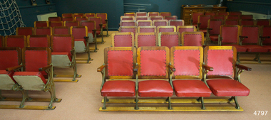 Flagstaff Hill Maritime Museum and Village
Furniture - Theatre Chairs, 1930's
These theatre chairs had been used in the Mozart Hall in Warrnambool for many years but are now no longer required. They were about to be offered for anyone to take but just by chance Flagstaff Hill’s Manager heard about them from a friend in Melbourne. Our Manager thought it important to keep the chairs in Warrnambool as they were significant to our local history and could be incorporated in our Museum. He made arrangements to collect and install them in Flagstaff Hill’s Theatrette. Originally these theatre chairs belonged to Warrnambool Town Hall. When The Warrnambool Baths (or Swimming Pool) in Gillies Street closed, due to the Health Act of 1958, the changing rooms were taken over by the Mozart Group. The building was modified and set up for musical concerts with the name Mozart Hall. The seats were re-covered by Miss Eva Gaspar, Director of the Warrnambool Music Society, with assistance from group members. The material was order by W.C. James (Treasurer) in 1964, at a cost of 26 pound and 10 shillings (£26-10), and supplied by Jacka-Wortley Fabrics Pty Ltd, Upholstery and Furnishing Supplies, 157-163 Pelham Street, Carlton, Melbourne, Victoria. The supplier’s telephone was “JACKAFAB” (5222 2322). The fabric was delivered to J. Hulin of 116 Belmore Rd, Warrnambool. The manufacturer of the chairs, Riddell & Preece Pty Ltd of Melbourne, also supplied theatre chairs for other public buildings including (1) the Ozone Theatre in Enfield, South Australia, in 1929, (2) the Gallery of the Horsham Town Hall in Victoria (at 26/6 each, that is 26 shillings and sixpence, approximate conversion in 2014 to $100.00au), (3) in 1927 in the Gallery of the Kyenton Mechanics’ Institute (4) in 1926, Horsham Theatre. (In May 2018 a transfer of three banks of chairs was made from Flagstaff Hill to the Australian Centre for the Moving Image in Melbourne.) The chairs are of local historical and social significance. Theatre chairs. The sixteen sets (groups or banks) of complete chairs, four seats per chair, give a total of 64 seats. Each chair has timber framed seats, with arm rests, upholstered in red vinyl. The seats are set into decorative gilt iron frames which incorporate five legs, all set into two timber floor rails. The seats are hinged to fold upwards and rest against the backrests. On ironwork "PTY. LTD"flagstaff hill, warrnambool, shipwrecked coast, flagstaff hill maritime museum, maritime museum, shipwreck coast, flagstaff hill maritime village, great ocean road, theatre chairs, theatre seats 1939, warrnambool town hall seats, mozart hall warrnambool, theatre furniture, mechanics’ institute chairs, j hulin warrnambool, mozart hall choral group, eva gaspar, warrnambool music society, w.c. james, jacka-wortley fabrics pty ltd -
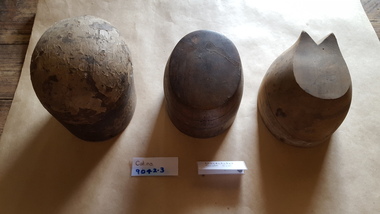 Coal Creek Community Park & Museum
Functional object - Three hat blocks
Oliver Gilpin (1874-1942), chain store proprietor, was born on 8 July 1874 at Seven Creeks near Euroa, Victoria, fourth child and second son of William Gilpin, farmer, and his wife Dinah, née Barton, both from Tyrone, Ireland. He was educated at local state schools and became a draper's assistant at Euroa. A testimonial as 'an energetic, pushing salesman, a careful stock-keeper … honest and industrious' gained him city experience with Ball & Welch Ltd, drapers, in their Carlton store. He used an inheritance to open a drapery store at Korumburra, south Gippsland, in 1895, moving to Rutherglen in the upper Murray valley in 1899. Frustrated by irregular stock deliveries, he moved to Fitzroy, Melbourne, in 1902, seeking a warehouse and the benefits of combined supplies for effective development of country trading. By 1905 he was producing many stock items at Northcote and had established retail outlets at Bendigo and Warracknabeal. Branches at Echuca, Numurkah and Yarrawonga followed in 1906, with ten more in 1907. He moved his city establishment to East Malvern in 1911, and had opened forty shops by 1920 and seventy-four by 1928. All were managed by women, on a strictly cash basis. Drapery remained the main line, supplemented by ironmongery, crockery, school requisites and toys. Gilpin saw the Depression years as a challenge. Between 1928 and 1931 he established eighteen new branches, including two in Tasmania, at Devonport and Ulverstone. The chain included South Australian branches at Mount Gambier, Millicent and Renmark, twenty-five stores in southern and western New South Wales, and ten in suburban Melbourne. Gilpin's Chain Store News was issued monthly. In 1944 Foy & Gibson acquired a controlling interest in Gilpin's business and in 1951 the chain was bought by G. J. Coles & Co. Ltd for £1,250,000. Three wooden blocks used to display hats. 9042.1 Slightly head shaped on top 9042.2 Light timber, flat on top, a wedge at back. 9042.3 Dark timber, flat on top.hat blocks, millinery, haberdashery, gilpin, korumburra -
 8th/13th Victorian Mounted Rifles Regimental Collection
Photograph
The Dibb Report into mainland defence of Australia,1986, among other things identified the requirement for protection of key assets in Northern Australia and the possibility of involving Army Reserve (Ares) units in this thus releasing regular forces for offensive operations. Dibb also pointed out that this defined role would result in a huge lift in Ares morale. In June 1988, the 3rd Division (3Div) conducted a Tactical Exercise without Troops (TEWT), Exercise ‘Distant Trumpet’ in the Katherine- Darwin area to study problems associated with defence against low level incursions against Tindal RAAF Base. Exercise ‘Northern Explorer’ followed in October of that year when units of the 3Div including A Squadron 8/13 Victorian Mounted Rifles sent patrol groups to get a first taste of environment and conditions. Post-Exercise reports had to include recommendations re: health, equipment and adaptation of Standing Operating Procedures (SOPs) in preparation for the new role deploying to Northern Australia. The first deployment by 8/13 Victorian Mounted Rifles was in 1988. Deployments continued in following years. In September 1993, 3 Troop (Wangaratta) VMR Squadron 4/19 PWLH commanded by Captain Kelvin Robertson deployed to NT. The training began with airfield defence at Tindal followed by a 1000km recon into Arnhem Land in four Landrovers. The troop reported on the conditions of the roads, airfields, bridges (mainly causeways) resources such as fuel supplies in the towns and infrastructure. Each troop taking different route. 3 Troop had the Northern route through Kakadu National park across the East Alligator River to Oenpelli then to Maningrida and Ramangining and south to the Central Arnhem Road and back to Tindal Air force Base Major Annett later commanded 4/19 Prince of Wales's Light Horse, and later again 4th Brigade 2nd Division.. Colour photograph of Major M. Annett, Officer Commanding VMR Squadron 4/19Prince of Wales's Light Horse during annual exercise Northern Territory 1994. -
 Bendigo Historical Society Inc.
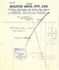
Financial record - INVOICE COLLECTION: BOLTON BROS PTY LTD
Bolton Bros. Pty Ltd. History tells us that Benjamin Bolton and his two eldest sons, William and Arthur, began a printing business known as Bolton & Sons on March 25, 1885. Since its commencement in 1885, Bolton Office National has been locally owned and operated and is committed to being the leader in the provision of service and procurement solutions. Located in Bendigo, Bolton’s Office National is Central Victoria’s premier service provider of office products & solutions, providing procurement solutions for Stationery & Office Supplies, Office Furniture & Equipment, Business Technology Equipment, Printing Services, Industrial & Corporate Workwear, Photocopiers & Multi-Function Device Support. The location of the original printing business was in High Street but later moved to Williamson Street where the business underwent a name change to Bolton Bros and expanded into manufacturing paper bags and other stationery lines. In 1902, Bolton Bros moved to 43 Mitchell Street, which housed the retail stationery department and the main office, while the printing factory was on the second and third floors. Next door at 47 Mitchell Street, the wholesale division and machine service department operated. William and Arthur Bolton and their sons travelled throughout central and northern Victoria selling their own products and representing other companies. They are credited with being the innovators of the loose-leaf ledger. Today, of course, the business is back in Williamson Street with an even greater presence but the same entrepreneurial flair that has seen it survive and flourish through everything history has thrown at it. Having gone through five generations of family ownership, current company director-David Bolton, is proud of his company’s history and contribution to the local economy. https://www.officenational.com.au/shop/en/boltons/about-us10934.25a Bolton Bros. Pty. Ltd. 30 April 1948 Invoice for 1000 ledger cards purchased by A. Stubley, Morton's Stores, Barham 10934.25b Monthly settlement AC Morton & Co. Little slips April 1938 10934.25c Invoice to AC Morton & Co. binders 9 October 1942 10934.25d Invoice to Mr Stubley 1 Jan 1946 10934.25e Bolton bros. Pty Ltd. letter/telegram 5th September 1945 From Bolton Bro's to Morton's Stores 10934.25f Follow up letter to Morton's Stores 10 Sep 1945 10934.25g Invoice 27 Aug 1940 10934.25h Invoice to Morton & Co. 20 Dec 1939bolton bros pty ltd., bendigo, morton's stores -
 Ballarat Tramway Museum
Newspaper, The Courier Ballarat, takeover of the Ballarat Electric supply by the SEC, Jul. 1927
Set of four newspaper clippings July 1927 from the Ballarat Courier regarding the possible takeover of the Ballarat Electric supply by the SEC. See also Reg. Item 1973 for other background to these clippings. 1974.1 - Courier 14/7/1927 - Reply by Sir John Monash of the SEC to Mr Pringle's (ESCo) speech - regarding price of power supplies, load factors, distance of supply, tariffs, tramway services. 346H x 57W 1974.2 - Courier 13/7/1927 - Large item in the Courier with statements by Sir John Monash and Mr. P. Pringle of ESCo each stating their case and various points regarding the cost of electricity to the various communities. 631H x 305W. 1974.3 - Single sheet of paper reprint from the Ballarat Courier - dated 14/7/1927 - titled "The Electric Supply Problem / Read this Leader from the 'Ballarat Courier' of 14th July 1927". Editorial address various issues of the problem - SEC takeover of the company, Council's power to franchise, dividends going overseas, loss of income to Council. Newspaper was seeking an independent report to Council. 303h x 206W 1974.4 - Courier 19/7/1927 - report of City of Ballaarat Council's 1927 consideration of the SEC's offer to takeover ESCo the previous night. Very detailed report of the discussions. Also a report on the City of Bendigo's decision to accept the SEC's position subject to the trams being kept, report on Electricity to farms and a long letter regarding the issue by W. B. Grose. 631H x 173W. Within the envelope containing this item, is the brown file that contained Reg. Items 1971 to 1977 by the Roneo London company.Dates of the newspaper clippings in pencil -plain or blueelectricity supply, sec, esco, city of ballarat, city of bendigo -
 Bendigo Historical Society Inc.
Document - Black and white laminated photo of flow of water from Lake Eppalock. 1964
John Perry Collection. Laminated copy of photo of crowd watching flow of water from the opened valve at the wall of Lake Eppalock during its commissioning. March, 1964. Lake Eppalock was created by flooding to town of Wild Duck. The dam was built by the State Rivers and Water Supply Commission of Victoria. The dam wall height is 45 metres (148 ft) and the main embankment is 1,041 metres (3,415 ft) long. At 100% capacity the dam wall was designed to hold back 304,651 megalitres (6.7014×10¹⁰ imp gal; 8.0480×10¹⁰ US gal) of water. The surface area of Lake Eppalock is 3,011 hectares (7,440 acres) and the catchment area is 2,124 square kilometres (820 sq mi). The controlled spillway is capable of discharging 8,040 cubic metres per second (284,000 cu ft/s). Lake Eppalock supplies both stock and domestic water to the Campaspe irrigation district. It also serves as a water supply to Bendigo and Heathcote and, in more recent times, Ballarat. The lake is a major attraction for those engaging in watersports, with a number of tourist parks and accommodation facilities available. Permissible activities on the lake include high-speed boating, water skiing, sailing, canoeing, fishing and swimming. The lake's water levels were low for approximately eight years between 2002 and 2010 during a prolonged drought, which restricted the amount of recreational activity until rainfall in the latter half of 2010 returned the lake to 100 percent capacity. Built between 1961 and 1964, Lake Eppalock remains the only water storage on the Campaspe River system.water, dam, reservoir, eppalock, wild duck -
 Bendigo Historical Society Inc.
Map - Map of Lake Eppalock shoreline when empty
John Perry Collection. Laminated copy of map detailing Lake Eppalock shoreline when empty. Circa 1951. Has colored highlighter lines following roads leading to lake shoreline and various inundated old roads and tracks on lakebed. The dam was built by the State Rivers and Water Supply Commission of Victoria. The dam wall height is 45 metres (148 ft) and the main embankment is 1,041 metres (3,415 ft) long. At 100% capacity the dam wall was designed to hold back 304,651 megalitres (6.7014×10¹⁰ imp gal; 8.0480×10¹⁰ US gal) of water. The surface area of Lake Eppalock is 3,011 hectares (7,440 acres) and the catchment area is 2,124 square kilometres (820 sq mi). The controlled spillway is capable of discharging 8,040 cubic metres per second (284,000 cu ft/s). Lake Eppalock supplies both stock and domestic water to the Campaspe irrigation district. It also serves as a water supply to Bendigo and Heathcote and, in more recent times, Ballarat. The lake is a major attraction for those engaging in watersports, with a number of tourist parks and accommodation facilities available. Permissible activities on the lake include high-speed boating, water skiing, sailing, canoeing, fishing and swimming. The lake's water levels were low for approximately eight years between 2002 and 2010 during a prolonged drought, which restricted the amount of recreational activity until rainfall in the latter half of 2010 returned the lake to 100 percent capacity. Built between 1961 and 1964, Lake Eppalock remains the only water storage on the Campaspe River system.map, eppalock, reservoir, lake, water -
 Bendigo Historical Society Inc.
Document - Directions to Lake Eppalock with road descriptions and map
John Perry Collection. Laminated copy of 'Directions to Lake Eppalock'. Gives directions in relationship of Lake Eppalock to Bendigo, Kyneton and Heathcote. Undated. Gives basic descriptions of bridges on lakebed, ford crossings on lakebed and inundated dwellings on lakebed. The dam was built by the State Rivers and Water Supply Commission of Victoria. The dam wall height is 45 metres (148 ft) and the main embankment is 1,041 metres (3,415 ft) long. At 100% capacity the dam wall was designed to hold back 304,651 megalitres (6.7014×10¹⁰ imp gal; 8.0480×10¹⁰ US gal) of water. The surface area of Lake Eppalock is 3,011 hectares (7,440 acres) and the catchment area is 2,124 square kilometres (820 sq mi). The controlled spillway is capable of discharging 8,040 cubic metres per second (284,000 cu ft/s). Lake Eppalock supplies both stock and domestic water to the Campaspe irrigation district. It also serves as a water supply to Bendigo and Heathcote and, in more recent times, Ballarat. The lake is a major attraction for those engaging in watersports, with a number of tourist parks and accommodation facilities available. Permissible activities on the lake include high-speed boating, water skiing, sailing, canoeing, fishing and swimming. The lake's water levels were low for approximately eight years between 2002 and 2010 during a prolonged drought, which restricted the amount of recreational activity until rainfall in the latter half of 2010 returned the lake to 100 percent capacity. Built between 1961 and 1964, Lake Eppalock remains the only water storage on the Campaspe River system.water, dam, directions, eppalock -
The Beechworth Burke Museum
Audio - Oral History, Jennifer Williams, Gwendoline Warden, 1st June 2000
Gwendoline Warden was born in Ararat in 1913. When she was 13 years old, she moved to Wangaratta, where her parents owned the “Hibernian Hotel”. Her father`s name was William Lavender. When Gwen was around 16 years old, she moved to Beechworth, where she met her husband and they got married in 1935. They had their wedding reception at Warden`s Hotel and they had two children together, a boy and a girl. She recounts how difficult it was for them during the war to manage their grocery's shop and source the supplies they needed, having coupons for food and the black-market prevailing. They faced financial difficulties and, ultimately, they had to sell the shop. After the war she did a few other jobs and she retired when she was nearly sixty. Gwendoline portrays Beechworth as a quiet place, where people were happy and peaceful, enjoying the many opportunities they had for entertainment, such as dances and balls, or the celebrations for the New Year's Eve. She also witnessed the beginning of the famous wheelbarrow race, which started just outside the post office and a big crowd gathered to farewell the two barrowmen. When comparing the past with the present, she points out how much Beechworth has changed over the last decades, with many new people coming to town, making her feel as “the only one around”. She also remarked that young people have changed as well; in her day they were entertaining themselves but nowadays they want to be entertained. This oral history recording was part of a project conducted by Jennifer Williams in the year 2000 to capture the everyday life and struggles in Beechworth during the twentieth century. This project involved recording seventy oral histories on cassette tapes of local Beechworth residents which were then published in a book titled: Listen to what they say: voices of twentieth century Beechworth. These cassette tapes were digitised in July 2021 with funds made available by the Friends of the Burke.Gwendoline Warden's account of her life in Beechworth and the local area during the 20th century is historically and socially significant as it offers valuable information about the business activity in the region and provides a deeper insight into the way hotels and grocery shops were operating during the first half of the previous century. Additionally, along with all the details provided for many aspects of social life, her personal account of the war period is of great importance, offering vital information to research on the way the Australian society experienced WWII. This is a digital copy of a recording that was originally captured on a cassette tape. The cassette tape is black with a horizontal white strip and is currently stored in a clear flat plastic rectangular container. It holds up 40 minutes of recordings on each side.Mrs Gwendoline Warden/ararat, wangaratta, hibernian hotel, gwendoline warden, william lavender, beechworth, warden`s hotel, grocery`s shop, coupons, black-market, war, dances, new year`s eve, balls, new people, listen to what they say: voices of twentieth century beechworth, jennifer williams, cassette tapes, friends of the burke, oral histories -
 Eltham District Historical Society Inc
Slide - Photograph, Monument with time capsule, Eltham Community Centre, Main Road, Eltham, c.Mar. 1989
The monument with time capsule was established by the Shire of Eltham Historical Society to commemorate Victoria’s 150th anniversary and mark the former location of the Eltham Town Centre, which existed along this section of Main Road, then known as Maria Street. The unveiling was conducted 10 November 1985 by Cr. Mary Grant (Shire President). The monument was constructed with a concrete base and the main feature is an old tyring plate or disc. The Time Capsule Ceremony involved lowering the sealed time capsule into place, bolting down its container lid and then concreting over the lid. The capsule contains items relating to present day (1985) Eltham and its people including a video film made by Joh Ebeli and also details of families and organizations who have contributed to construction of the monument. It is to be opened in the year 2035. The Society received an excellent response from local people, firms and organizations by way of assistance with this project. Graham Beyer, who originated the project, arranged many of the donations. He and his firm, Package Handling Equipment, donated the time capsule itself and carried out fabrication of sections of the monument. The design of the monument was adapted by Graham Beyer from drawings by Joh Ebeli. Charmac Industries donated the container for the time capsule and a cast gun metal name plate for the monument. BMG Concrete donated concrete for the base which was constructed by Caridi Construction Company. Northbourne Garden Supplies donated materials for the paving around the monument. Robert Becker from Eltham Apex directed construction of the paving by Society members. Terry Hutchinson donated the use of his crane to lift the tyring disc into place. Financial contributions were also made by the Eltham Chamber of Commerce and the Rotary Club of Eltham. In 1987 in commemoration of the Society’s 20th Anniversary, Joh Ebeli suggested the commissioning of a plaque to be added which explains the functions of the various items used in the Society’s Victorian 150th Anniversary Monument and this was unveiled by its designer, Joh Ebeli, on October 10, 1987.35mm colour positive transparency (1 of 28) Mount - Kodak KodachromeProcess Date MAR 89Meltham, eltham community centre, monument, time capsule