Showing 1046 items
matching trails
-
 Eltham District Historical Society Inc
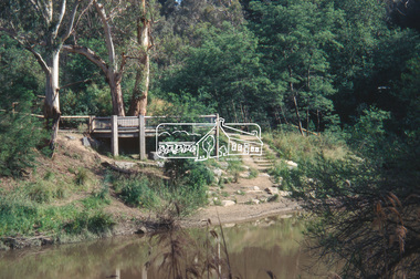
Slide - Photograph, Viewing platform near the confluence of Diamond Creek and Yarra River, c.Nov. 2001
In October 1996 the viewing platform was opened. It is situated near Lenister Farm on the Diamond Creek trail. It was a joint project involving Nillumbik Shire Council, Skill Seekers Inc., Department of Natural resources and Environment and Department of Employment, Education, Training and Youth Affairs. The platform was officially opened by Don Cordell Chairman of Commissioners. Part of a slide show presentation "A Trip Down the Diamond Creek" by Russell Yeoman to the Eltham District Historical Society meeting of 14 Nov. 200135mm colour positive transparency Mount - Black and Whiteconfluence, diamond creek, yarra river, viewing platform -
 Falls Creek Historical Society
Booklet - Falls Creek Information 2006
Falls Creek 2006 included a wide range of new developments and activities. Some of these were Pete the Snow Dragon shows, Fox Trail, Women's Program, the Mouse Trap. Monkey Bar and Bungy Trampolining as well as night-time activities. The purchase of a Park Bully Kassbohrer snow groomer ensured an international standard freestyle terrain was maintained. The Falls Creek snowmaking system and snow farming also was given a huge boost with Wombats Ramble going on-line in 2006.This booklet is significant because it introduces a wide range of new activities and facilities at Falls Creek in 2006.A glossy publication of 48 pages promoting Falls Creek all year round. It includes detailed information of activities at Falls Creek, images and advertising.falls creek activities, snow grooming, snow making at falls creek -
 Falls Creek Historical Society
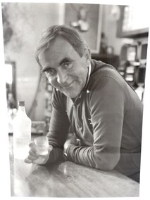
Photograph - Portrait Ory Frueauf
This photograph was taken circa 1981 - 1982 by Tourism Victoria. Orest “Ory” Frueauf was born in Kharkov, Russia in 1925 and moved to Germany with his family to escape persecution. He was conscripted to the German Army during the Second World War. He was a POW until 1948. He was recruited by a French construction company to work as and interpreter on a hydroelectricity project in Tasmania. Ory then moved to work on the Snowy Mountain Scheme including driving a truck to fill the wall of the Rocky Valley dam. In 1952 Ory was recruited by the Albury Ski Club as its lodge supervisor. That year he also entered into a business partnership with Cecil Dobson, running the general store “Whitehaven” and Post Office at Falls Creek. They extended their business by adding accommodation turning Whitehaven into one of the best commercial lodges at Falls Creek. Ory and Cecil dissolved their business partnership in 1963 and Ory went on to build a new lodge called “Snowhaven” at the site of the present day Frueauf Village, Falls Creek. The trail known as Ory's Trail is also named in his honour. Ory retired to Tawonga, Victoria in 1992 and passed away in 1999.This image is significant because it portrays a pioneer of Falls Creek.A4 size black and white photograph of Ory Frueauf standing at the bar at Snowhaven Lodge with Vovka-Finlandia VodkaOn back of photograph: Orest Freauf 1925-1997. 1925 - Born in Kharkov, Russia, 1951 Tasmania Hydro Electric Co; 1954 Howman's Gap, Kiewa Hydroelectric Scheme; 1955 Falls Creek Trading and Transport Co; 1957 Winterhaven Ski Lodge; 1963 Snowhaven Ski Lodge; 1992 Tawonga Southory freauf, hydro electric, tourism victoria, winterhaven ski lodge, snowhaven ski lodge, snow, orest frueauf -
 National Vietnam Veterans Museum (NVVM)
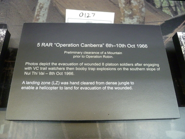
Poster - Poster, Information Board, 5RAR "Operation Canberra" 6th-10th Oct 1966
A black board with white text about "5RAR "Operation Canberra"6th-10th Oct 1966"5RAR "Operation Canberra" 6th-10th Oct1966 Premilinary clearance of a Mountain prior to Operation Robin. Photos depic the evacuation of wounded 8 platoon soldiers after engaging with VC trail watchers then booby trap explosions on the southern slope of Nui Thi Vai - 8th Oct 1966 A landing zone (LZ) was hand cleared from dense jungle to enable a helicopter to land for evacuation for the wounded.honours and awards, 5 rar -
 Clunes Museum
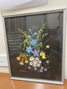
Painting, F.R. ANDERSON
DEPICTION OF THE PLANTS GROWING ON MOUNT BECKWORTH, NEAR CLUNES, VICTORIA, AUSTRALIASILVER PAINTED WOODEN FRAMED PAINTING UNDER GLASS. BLACK BACKGROUND. DRAWING OF MT. BECKWORTH FLOWERS BY F.R. ANDERSON, CRESWICK. FLOWERS NAMED ON BACK OF PAINTINGON REVERSE - HANDWRITTEN IN BLUE BIRO ON NOTE PAPER: NATIVE FUSCHIA CLOCKWISE FROM:- CORREA REFLEXA GREEN SPIDER ORCHID CALADENIA GOLDEN SPRAY VIMINARIA BLUE SUN ORCHID THELYMITRA BEARDED ORCHID CALOCHILUS MAUVE WAXLIP ORCHID GLOSSODIA YELLOW RABBITS EARS THELYMITRA TRAILING FRINGED LILY THYSANOTUS MILKMAID'S BURCHARDIA TAPED HANDWRITTEN NOTE: "MT. BECKWORTH FLOWERS BY F.R. ANDERSON, CRESWICK"mt beckworth, australia native plants -
 Eltham District Historical Society Inc
Negative - Photograph, J.A. McDonald, Eltham-Yarra Glen Road, Lower Plenty, c. July 1962
View looking west across the Eltham-Yarra Glen Road approaching the Lower Plenty Bridge near turn-off for the Golf Club Hotel. Present-day Lower Plenty Road follows a revised alignment across a new bridge. The former bridge is now part of the Plenty River Trail and Edward Willis Court now follows this section of the original Eltham-Yarra Glen Road.. The Golf Club Hotel is gone and a new Lower Plenty Hotel was built slightly further up the hill.Record of various Shire of Eltham infrastructure works undertaken during the period of 1952-1962 involving bridge and road reconstruction projects, sometimes with Eltham Shire Council Project Reference numbers quoted. It was during this period that a number of significant improvements were made to roads and new bridges constructed within the shire that remain in place as of present day (2022). In many situations, the photos provide a tangible visible record of infrastructure that existed throughout the early days of the Shire. The album was put together by or under the direction of the Shire Engineer, J.A. McDonald.1962-07, shire of eltham, old eltham road, edward willis court, eltham-yarra glen road, golf club hotel, infrastructure, lower plenty, road construction -
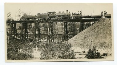 Orbost & District Historical Society
black and white photographs, 20th century
These photographs are probably of bridges on the East Gippsland railway line. 3162.2 is possibly Hospital Creek and 3162.3 possibly Burn Road Newmerella. The Orbost-Bairnsdale railway initially played a crucial role in developing agricultural industries in Gippsland as well as tourism. It opened in 1916 and operated until 1987, principally carrying timber and farming produce. In the early days of the railway's operation dedicated passenger trains ran but these ceased by the 1930s. The line was completely closed to freightage in 1987.The track infrastructure was dismantled in 1994 and has been redeveloped as the East Gippsland Rail Trail.These photographs are associated with the history of the Orbost-Bairnsdale railway line and therefore reflects the role that the rail line played in the social and economic history of Orbost. Three black / white photographs of railway bridges. 3162.1 has a steam train on the bridge. 3162.3 shows three men on the right working at clearing vegetation. 3162.3 has been taken from a height.orbost-bairnsdale-railway east-gippsland-railway bridges-railway -
 Moorabbin Air Museum
Archive (Item) - Box Baa 104 Boeing (Gaf / Asta) Collection
Description: - JINDIVIK TRIAL DATA File labelled “Historical Use” - Correspondence between Senior Representative , Dept of Supply, Australia House, London and GAF 02/01/1974 to 30/12/1975 Jindivik - Trailing Edge Pressures - Trials Jindivik 2B Trials - Level of Importance: National. Historical Details: DAP/GAF/ASTA constructed many overseas designs under licence in Australia (Beaufort, Beaufighter, Lincoln, Canberra and F18) however they also designed and constructed a number of significant local designs that were successful in oversea's markets includiCAC -
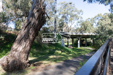
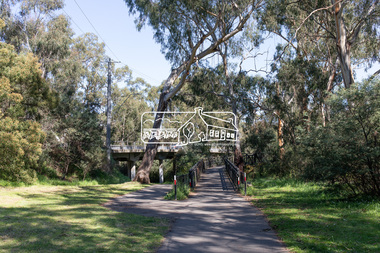
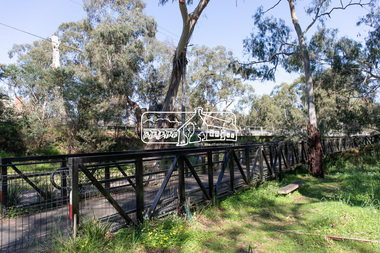 Eltham District Historical Society Inc
Photograph, Peter Pidgeon, Manna Gum, Main Road Bridge, Eltham South, 8 Sep. 2021
This significant tree located near the Main Road Bridge and Diamond Creek Trail footbridge over the Diamond Creek at Eltham dates back to the early 1900s. The original timber bridge over the Diamond Creek was built around 1840. It was destroyed by floodwaters in October 1923. A temporary bridge was rigged up but further damaged in April 1924. A new concrete bridge was built and opened in October 1926. The bridge decking was widened along with Main Road to Dalton Street by the Road Construction Authority in 1984., The uygraded bridge was opened in October 1984, 78 years after its original opening.These trees are not only significant for the natural environment but also present a navigational beacon back in time as the environmental landscape is developed around them.Born Digitaleltham south, main road bridge, manna gum, significant tree, diamond creek trail -
 Eltham District Historical Society Inc
Photograph, Peter Pidgeon, Manna Gum, Main Road Bridge, Eltham South, 8 Sep. 2021
This significant tree located near the Main Road Bridge and Diamond Creek Trail footbridge over the Diamond Creek at Eltham dates back to around 1870-1880. The original timber bridge over the Diamond Creek was built around 1840. It was destroyed by floodwaters in October 1923. A temporary bridge was rigged up but further damaged in April 1924. A new concrete bridge was built and opened in October 1926. The bridge decking was widened along with Main Road to Dalton Street by the Road Construction Authority in 1984., The uygraded bridge was opened in October 1984, 78 years after its original opening.These trees are not only significant for the natural environment but also present a navigational beacon back in time as the environmental landscape is developed around them.Born Digitaleltham south, main road bridge, manna gum, significant tree, diamond creek trail -
 Eltham District Historical Society Inc
Photograph, Peter Pidgeon, Manna Gum, Main Road Bridge, Eltham South, 8 Sep. 2021
This significant tree located near the Main Road Bridge and Diamond Creek Trail footbridge over the Diamond Creek at Eltham dates back to around 1870-1880. The original timber bridge over the Diamond Creek was built around 1840. It was destroyed by floodwaters in October 1923. A temporary bridge was rigged up but further damaged in April 1924. A new concrete bridge was built and opened in October 1926. The bridge decking was widened along with Main Road to Dalton Street by the Road Construction Authority in 1984., The upgraded bridge was opened in October 1984, 78 years after its original opening.These trees are not only significant for the natural environment but also present a navigational beacon back in time as the environmental landscape is developed around them.Born Digitaleltham south, main road bridge, manna gum, significant tree, diamond creek trail -
 Eltham District Historical Society Inc
Photograph, Peter Pidgeon, Manna Gum, Main Road Bridge, Eltham South, 8 Sep. 2021
This significant tree located near the Main Road Bridge and Diamond Creek Trail footbridge over the Diamond Creek at Eltham dates back to the early 1900s. The original timber bridge over the Diamond Creek was built around 1840. It was destroyed by floodwaters in October 1923. A temporary bridge was rigged up but further damaged in April 1924. A new concrete bridge was built and opened in October 1926. The bridge decking was widened along with Main Road to Dalton Street by the Road Construction Authority in 1984., The uygraded bridge was opened in October 1984, 78 years after its original opening.These trees are not only significant for the natural environment but also present a navigational beacon back in time as the environmental landscape is developed around them.Born Digitaleltham south, main road bridge, manna gum, significant tree, diamond creek trail -
 Eltham District Historical Society Inc
Photograph, Pedestrian suspension bridge over the Yarra River at Lower Plenty, 18 Apr 1998, 1998
Lower Plenty Heritage Excursion included the former monastery of the Blessed Sacrament Fathers, now Odyssey House, and its suspension footbridge across the Yarra River. Odyssey House drug rehabilitation centre in Bonds Road, Lower Plenty is a distinctive landmark, especially when viewed from across the Yarra at Templestowe. It was built in the 1950’s as a seminary for the Blessed Sacrament Fathers. Because of the poor and circuitous road access, a suspension footbridge was built across the river. As well as providing easy access for the priests residents of Templestowe could attend services at the seminary. The bridge is now part of the Yarra Trails system.Roll of 35mm colour negative film, 6 strips Also photographic prints 10 x 15 cmKodak Gold 200-6activities, blessed sacrament fathers, bonds road, bridge, foot bridge, lower plenty, odyssey house, seminary, yarra river -
 City of Greater Bendigo - Civic Collection
Leisure object - Netball ball, Australian Diamonds Netball Team, 2014
The Australian Women's netball team the Diamonds, played England in Bendigo on Sunday October 19, 2014. 'Fresh from a four-Test Constellation Cup clean sweep against New Zealand last week, the Diamonds started the game at a blistering pace, with wing attack Madi Robinson running rings around her rivals. England tried to go with them but the trade-off was a high error count and while they settled in the second quarter they still trailed 29-17 at halftime'. www.theguardian.com/sport/2014/oct/19/australian-diamonds-crush-england-in-first-netball-testSigned 'Gilbert' netball in acrylic display case. Wooden base with plaque on front.Australian Diamonds Team / International Test Series Netball / Australian Diamonds V England / 19 October 2014, Bendigo Stadium / Score Australia 55 - England 37 (Signed) Caitlin Bassett, Laura Geitz, Kim Ravaillion, Madi Robinson, Caitlin Thwaites, Susan Pettitt, April Brandley, Courtney Bruce, Jo Weston, Gabi Simpson, Liz Watson, Stephanie Wood.city of greater bendigo sport, bendigo stadium -
 Melbourne Tram Museum
Document - Notice, Melbourne & Metropolitan Tramways Board (MMTB), "Trolley Poles and Trolley Ropes", 1963
Set of five circulars about Trolley Poles and their use on trams: 1 - Emergency Trolley Rope - fitting to trams - foolscap dated 25/10/1963 2 - trolley poles and climbing onto the roof - quarto dated 17/12/1963 3 - Procedure for placing front trolley pole in trailing position - foolscap - 20/12/1963 4 - Trolley pole rope guide clip - two foolscap sheets with space for an photo - 11/11/1964 5 - Trolley pole rope guide clip - quarto sheet dated 12/11/1964.Yields information about the use of trolley poles on Melbourne trams.Document - Set of five foolscap or quarto sheets, duplicated, each with two punched holes on left side.tramways, instructions, trolley poles, operations, safety -
 Warrnambool and District Historical Society Inc.
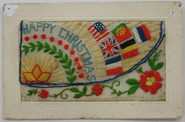
Document, Postcard embroidered, 1918
Embroidered cards such as this one were made by the French (usually women) for use as post cards for World War One soldiers to send home as greeting cards. The gift card with the embroidered card may not have been originally with it. The embroidered card has the date of October 1918, just one month before the official end of the war in November 1918. The name of the person who wrote ‘Somewhere in France’ on the back of the card is not listed but the handwriting appears to be similar to that on another card in our collection which is from R. Kerr from Kerr Street in Warrnambool. No information has been found on this soldier named Kerr. This embroidered card is of considerable significance as a very attractive memento of World War One and one, presumably, with local provenance. .1 The embroidered card is a World War One post card. The embroidery is on silk mounted on a white card. The embroidery is in yellow, blue, red, white and green colours and features a trail of flowers, a rising sun, six national flags, the words ‘Happy Christmas’ and other ornamentation. The embroidery is in two sections with a lift up section that could hold another card or note. The handwriting on the back has been written in pencil. The post card section has not been franked or posted. The card has marks at the edges where it has been attached to a surface with pins. The card is a little stained. .2 This is a small gift card with a coloured image of a girl with a basket of flowers.Embroidered card - ‘Happy Christmas’ ‘Somewhere in France 8/10/18’ Small gift card – ‘A Christmas Wish’ world war one and warrnambool, warrnambool historical society -
 Eltham District Historical Society Inc
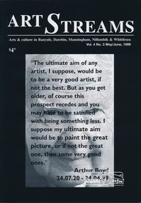
Journal, Peter Doughtery, ArtStreams: Arts & Culture in Banyule, Darebin, Manningham, Nillumbik & Whittlesea; Vol. 4, No. 3, May-Jun 1999, 1999
Vol. 4, No. 3, May-Jun 1999 CONTENTS HEIDELBERG SCHOOL REVISITED Artist's Trail extended 5 FROM JACKEROO TO ARTIST Geoffrey Dance interviewed 8 VCE TOPCATS 10 'ARTIN ABOUT 13 FERGUSON'S PADDOCK, HOME TO CHALLENGING NEW SCULPTURE 15 LA MAMA & THE COMEDY FESTIVAL 17 THE POETRY OF HISTORY The Hanging of Jean Lee 18 MUSEUM OF MODERN ART exhibitions and future plans 34 SHORT STORY High Voltage 22 DINING OUT WITH SIGMUND JORGENSEN 24 CD REVIEWS 26 BOOK REVIEWS 30 CAFE & RESTAURANT LISTINGS 32,33 "Peter Dougherty has been involved in the local art scene for many years. As publisher and editor of the arts magazine Artstreams, his comments on the various branches of the arts are widely respected. His "The Arts" column in the Diamond Valley Leader presents a brief summary for a much wider cross section of the local community. Peter also operates his own gallery and the Artstreams Cafe at the St Andrews market. Peter has a wealth of knowledge about present day and historical aspects of local art and artists." - Eltham District Historical Society Newsletter No. 161, March 2005Colour front and back cover with feature articles and literary pieces with photographs and advertisements printed in black and white. 36 pages, 30 cm. Vol. 1, no. 1 (Nov. 1996) - Vol. 10, no. 5 (summer ed. 2005/06) art streams, arthur boyd, know & grow, heidelberg artists' trail, carlucci's, geoffrey dance, vce art, kasimir burgess, clare james, andrew kelly, jason harris, nichaud fitzgibbon, noella clohesy, willy wonka's ice cream gourmet food, natalie troubnicova, ellen mileo, fergusons paddock, cathy smith, la piazza restaurant bar & cafe, la mama theatre, comedy festival, anne delaney, jordie albiston, dymocks booksellers, dynamic vegies, alison lonsdale, montsalvat, sigmund jorgensen, jacques reymond's restaurant, yarra valley country club, leslie avril, caitlin ogden, geoff achison, neil adam, judy turner, wild hill dog, louis mcmanus, adams of north riding, lovegroves of cottles bridge, artspeak studio gallery, peter sculthorpe, elizabeth scarlett, carmel bird, michelle lonsdale, museum of modern art at heide, st andrews hotel, volumes -
 Eltham District Historical Society Inc
Photograph, 1934 Floods at Eltham
Published in the Diamond Creek Basin Study, 1980 and identified at Diamond Creek, locality not identified, 1934. The location is actually looking south across the Diamond Creek towards Falkiner Street, beside the Main Road bridge at Eltham South from what is now part of Wingrove Park opposite Antoinette Boulevard. The bridge railing is just visible to the left of image. The large leaning Manna Gum beside the bridge still stands in 2021 alongside the Diamond Creek trail. In 1934 extensive flooding of the Yarra River and Diamond Creek set new records for flood plain level (Eltham Chronology, EDHS)Black and white photographCopied by Hugh Fisher, Photographer, 6 York Street Eltham A1678B Floods- Eltham - 1934floods, yarra river, eltham, flooding, diamond creek, flood -
 National Vietnam Veterans Museum (NVVM)
Weapon, Montagnard Dagger
Montagnard Dagger, C 1964, souvenired by Major Ian McKeown, Australian Army Training Team Vietnam (AATTV). The Central Highlands emerged as a strategically important area during the Vietnam War, because it included the Ho Chi Minh trail, the North Vietnamese supply line for Viet Cong forces in the south. communists passing through the highlands had, however, to contend with the Montagnards who they called Thurong (highlanders). The Montagnards were a formidable opponent in their home terrain and were not adverse to using their traditional weapons when dispatching their enemies, particularly when maintaining silence was critical. On loan courtesy the collection of Ian McKeownWooden handle. Metal reinforcement both ends of handle. Metal curved blade with concaved tip.maj mckeown, aattv, australian army training team vietnam (aattv), montagnard dagger, montagnards -
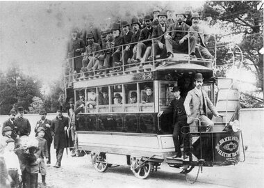 Ballarat Tramway Museum
Photograph - Black & White Photograph/s, Sep. 1888
Yields information about the trails of an alternative method of propulsion of tramcars - electric battery. Shows the vehicle while on trial in Melbourne. Shows the people involved in the trials.Black and White copy photograph of a State Library of South Australia SLSA B34583, of the Julien battery-electric tramcar on trials in Toorak Road, Melbourne; see page 27 of The Golden City and its Tramways and for the photo itself. Trails undertaken September 1888. Collected by Alan Bradley from the State Library of South Australia early 1980's. For details of the Adelaide trials - see https://commons.wikimedia.org/wiki/File:Julien%27s_Patent_battery_tram,_Henley_Beach,_9_January_1889_(SLSA_B-5468).jpg (accessed 22/8/2020). And the Oct. 1977 issue of Trolley Wire, for the construction, testing and disappearance of the tram. 3791.1 - 2nd print obtained by William F Scott on light weight paper - 2 copies2785.1 - on rear of both copies in ink "Trial run of battery electric car in South Yarra (Melbourne) on cable car tracks. 1888. The same car ran in Ballaarat shortly there after." In pencil "Photograph courtesy of the State Library of South Australia SLSA B 34583"tramways, trams, duncan fraser, battery trams, julien system, melbourne -
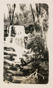 Kew Historical Society Inc
Photograph - Grampians, 1924
Henry Beater Christian (1886-1962) , was a descendant of one of the earliest settler families in Kew. Employed at the Kew Asylum as a 'public servant', he was a skilled amateur photographer, photographing numerous scenes in Kew and on his travels around Victoria. The majority of his photographs date from 1916 to 1929. His finest photographs are housed in two photograph albums. Digital copy of a photograph from page 13 of the 47-page photograph album containing 261 gelatinous silver images, loaned by Diane Washfold with permission given to digitise and hold a copy in our collection. The first and last pages in the album document the Yarra River at Studley Park and at Kew. The remainder of the album includes photographs of walking and car tours in rural Victoria including 'wilderness' areas in the Grampians, Gippsland and the High Country. Six album pages document a camping trip by Henry Christian to the Grampians in September 1924. The photos include pictures of lookouts, and natural features including rock faces and waterfalls, as well as his camp site. This photo is of one of a waterfall on one of the walking trails. Unitled [Grampians]henry beater christian (1886-1962), landscape photography, christian-washfold collection, photograph albums, grampians, gariwerd -
 Melbourne Tram Museum
Pamphlet, Public Transport Corporation (PTC), "Free City Circle Tram", mid 1990's
Pamphlet - eight fold to DL size, full colour, titled "Free City Circle Tram" with a photo of a City Circle tram passing Flinders St station. Has information about Melbourne trams, the Melbourne Town Hall, Visitor Information, Walking Trails, a map of the route, with places of interest shown. Map shows the service via Spencer St. Has photos of 2013 and 909 as well. Has the City of Melbourne, Department of Infrastructure and Public Transport Corporation logos. Possible produced during the mid 1990's given the various logos used. .1 - As above, but with Yarra Trams and State Government logos See Reg Items 1387 and 2703 for other versions.trams, tramways, city circle, melbourne, public transport corporation, ptc -
 Eltham District Historical Society Inc
Photograph - Aerial Photograph, Landata, Eltham, Vic, Apr. 1972
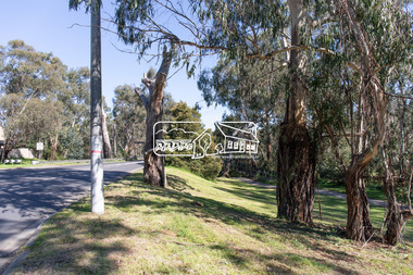
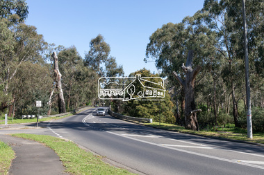
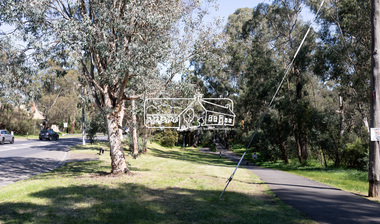
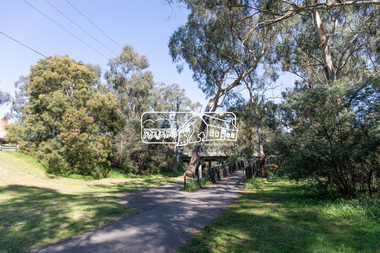
Centred on present day Diamond Creek Trail at the Eltham Leisure Centre bounded by Central Park to north, Main Road at Falkiner Street to south, MacMahon Ball Paddock to east and Grand Boulevard at Buena Vista Drive to west. Historic Aerial Imagery Source: Landata.vic.gov.au Aerial Photo Details: Project No :985 Project : MELBOURNE 1972 Run : 28 Frame : 207 Date : 04/1972 Film Type : B/W Camera : RC10 Flying Height : 5700 Scale : 9600 Film Number : 2635 GDA2020 : 37°43'25"S, 145°08'20"E MGA2020 : 335985, 5823223 (55) Melways : 21 G7 (ed. 42)aerial photo, neil webster collection, 1972-04, eltham, buena vista drive, central park, diamond creek trail, eltham leisure centre, falkiner street, grand boulevard, macmahon ball paddock, main road, melway 21g7 -
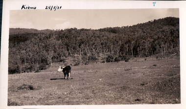 Kiewa Valley Historical Society
Black and white photograph of farmland, Kiewa, 25/8/38, circa 1938
This photograph was taken in August, 1938, some eight years prior to the establishment of Mt. Beauty a a township. The area was still being used for grazing, and the land was eventually acquired from the local land owners by the State Electricity Commission. The construction of the road, from Tawonga to the High Plains, was commenced in April, 1938 and this photograph was taken August, 1938. This allowed men and heavy equipment to be transported to the work sites for the construction of the Kiewa Hydro Electric Scheme. Prior to this access was by bridle trail, either on horse back or on foot. By 1946 housing construction had commenced for the new town of Mt. Beauty and by 1948 street construction in the southern part of the town was completed as far as Hill Street.This photograph is important as it shows the upper Kiewa Valley as it was before the establishment of the town of Mt. Beauty. The land has been cleared of natural vegetation to allow grazing of cattle. Black and white photograph of grazing farmland with one animal standing in the paddock. The area could possibly be where the golf course now stands with the road to the high plains not yet commenced.Handwritten in the upper left hand corner 'Kiewa 25/8/38'. The number 7 has been stamped in the upper right hand corner. It is part of a set of 8 photographs. On the back are the words Velox repeated several times, indicating the type of photographic papergrazing, kiewa, mt. beauty, secv -
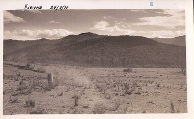 Kiewa Valley Historical Society
Photograph Farm Land, Kiewa, 25/8/38, circa 1938
This photograph was taken in august, 1938 some eight years prior to the establishment of Mt. Beauty as a township. The area was still being used for grazing cattle and the land was eventually acquired from the local land owners by the State Electricity Commission. The construction of the road, from Tawonga to the High Plains, was commenced in April of 1938. This allowed men and heavy equipment to be transported to the work sites for the construction of the Kiewa Hydro Electric Scheme. Prior to this access was by bridle trail, either on horse back or by foot. By 1946 housing construction had commenced for the new town of Mt. Beauty and by 1948 street construction in the southern part of the town was completed as far as Hill Street.This is an important photograph as it shows the upper Kiewa Valley and the site for Mt. Beauty as it was before the establishment of the town. The land has been cleared of natural vegetation and used for grazing cattle.Black and white photograph of farmland, cattle in the distance, hills in the backgroundHandwritten in the upper left hand corner, in black ink, 'Kiewa 25/8/38'. The number 8 has been stamped in the upper right hand side of the photograph. On the back have been stamped the words Velox, indicating the type of photographic paper.kiewa, mt. beauty, construction, grazing, secv -
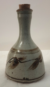 Ballarat Heritage Services
Photograph - ceramics, Nintingbool Potteries, Bottle by Nintingbool Potteries
Stephen Drew was Nintingbool Potteries Stephen (Steve) Drew studied at the Ballarat Technical Art School (a division of the Ballarat School of Mines) and RMIT. He worked as a secondary school teacher for a short time before setting up Nintingbool Potteries in a bush setting at Smythes Creek, near Ballarat, in 1974. He made a wide range of functional pottery high-fired in stoneware and porcelain, later concentrating on one-off sculptural pieces. Steve Drew was instrumental in setting up the Ballarat Ceramic Group, which operated for twenty years, and is a member of the Golden Plains Art Trail. His pottery mark is recorded as an impressed 'N' in a circle, or an incised 'Drew'. Bell shaped bottle by Nintingbool Potteriesaustralian studio pottery, ceramics, bottle, steve drew, stephen drew, nintingbool potteries, ballarat pottery group