Showing 492 items matching "yarra glen"
-
 Koorie Heritage Trust
Book, Barraclough, Linda et al, A valley of glens : the people and places of the Upper Macalister River, 1988
Contents: Exploration & the Heyfield run; Glenmaggie, Glenfalloch & Glencairn; Gold & the first farms; The town begins; The farms are established; Selection to the limits; Fire, flood, drought, rabbits & other forms of pestilence; The second exploration; The weir is built; A time of change; Today & tomorrow.ix, 177 p. : ill. ; index; footnotes; sources; 25 cm.Contents: Exploration & the Heyfield run; Glenmaggie, Glenfalloch & Glencairn; Gold & the first farms; The town begins; The farms are established; Selection to the limits; Fire, flood, drought, rabbits & other forms of pestilence; The second exploration; The weir is built; A time of change; Today & tomorrow.upper macalister river -- east gippsland-history -
Southern Sherbrooke Historical Society Inc.
Information folder - Glen Harrow, 2000
Information folder containing items pertaining to Glen Harrow, Belgrave. Contents:/article, 'Glen Harrowing times', Our House (Channel 9), September 2000glen harrow, marg & lou hesterman -
 Southern Sherbrooke Historical Society Inc.
Information folder - Glen Park
Folder containing information pertaining to the history of Glen Park homestead, Menzies Creek. Contents: -two pages photocopied from "That Little Train" by Peter Cuffley, showing four photos of Glen Park homestead and a short history of Edwin Johns at Glen Park (2 copies of each) -articles, "No. 861's full steam ahead again", photo shows Col Rees with Coonara Community School students, and "Living the dream" re. engine no. 861. On verso, "A Family Reunited", article by Emerald Tourist Railway re. locomotives, and "Colin just loves steam locomotion" re. engine no. 861. -4 letters, from Puffing Billy Railway, in support of Col Rees. -Letter, dated 19 June 1996, from Emerald Tourist Railway, re. appeal for restoration of Garratt engine. On verso, copy of certificate awarded to Col Rees for donation to appeal. -Letter, 1 June 1998, re. Garrett appeal. On verso, certificate awarded to Col & Kellie Rees for donation to appeal. -Aerial photo showing proposed property boundaries of Glen Park subdivision. -Aerial photo showing existing property boundaries of Glen Park. NB. last four items provided to society by Col Rees in support of subdivision. -Memorandum dated 2 May 2000 from Graham Whitt, Shire of Yarra Ranges, to Shire Service Centres, re proposed division of Glen Park land. -Fax, dated 13 June 2000, from Southern Sherbrooke Historical Society to Shire of Yarra Ranges, re. intention to make submission. -Letter, dated 14 June 2000, acknowledging receipt of above fax. -Submission, dated 18 June 2000, from Southern Sherbrooke HS, expressing concern re. proposed subdivision of Glen Park. -Fax, dated 27 June 2000, from Dianne Kueffer to Susan Heywood-Downard, Agenda Item 2 of the Yarra Ranges Planning Committee Agenda 14 March 2000, including detailed description of proposed subdivision and map. -Letter, dated 7 July 2000, Shire to Society, re. discussion of Glen Park subdivision by council. -Letter, dated 7 July 2000, Society to Shire, re. withdrawal of objection subject to certain conditions. -Letter, dated 14 July 2000, Shire to Society, re. council resolution to allow subdivision of Glen Park. -Letter, dated 24 October 2000, Shire to Society, stating that amendment to Planning Scheme allowing subdivision was approved by council and gazetted on 19 October 2000. -seven A3 sheets, showing house and property plans for new constructions proposed for Lot 1 of Glen Park subdivision. -diagram, hand-drawn (by Col Rees?) on lined A4 sheet, showing proposed development. -A1 sheet, Plan of feature survey of Lot 2 Blackhill Rd, Selby, dated 12 April 2000, showing contours, vegetation, proposed location of buildings, etc. -Glen Park Homestead and Cyprus Avenue, document prepared for the Shire Of Yarra Ranges by Helen Lardner Conservation & Design P/L, June 2003edwin johns, breen family, col & kellie rees, puffing billy -
 Southern Sherbrooke Historical Society Inc.
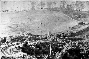
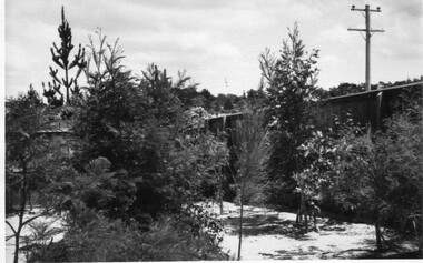
Photograph - Photo-black & white-Puffing Billy track and water tower
Photograph of the railway line to Gembrook and the water tank at Menzies Creek in the centre of the picture. This area, known as The Tanks, is the site of the landslide that closed the railway down in 1953. Glen Park homestead is on top of the hill on the left. -
 Southern Sherbrooke Historical Society Inc.
Photograph - Glen Park homestead, Menzies Creek
Colour photograph of Glen Park homestead at Menzies Creek prior to its demolition in the early 2000's. Photo shows house's north wall with two gables and a verandah between. Photo from Victorian heritage study. -
 Southern Sherbrooke Historical Society Inc.
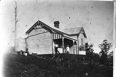
Photograph - Glen Park Homestead, Percy and Cissy Johns on verandah, early 1900s
B&W photo shows siblings Percy and Cissie (Minnie Agnes) Johns on the verandah of their home, Glen Park Farm, Selby. Percy looks in his early teens, making the photo around 1910 or later. He is wearing a long-sleeved pale shirt, long dark trousers tucked into knee-high boots, and possibly a dark hat. Cissie is wearing a pale, knee-length dress, dark stockings, and a pale, wide-brimmed hat. She is aged about 10. A medium sized dark dog sits at Percy's feet. The house is an L-shaped weatherboard with two gables at right-angles and a verandah with a bullnosed roof, ornate support posts, and a striped end piece from the roof. Wooden steps lead down from side. There is a large brick chimney where the two wings meet, and a metal water tank to the side. There are large trees, both in leaf and dead, plus some flowers near the verandah. -
 Southern Sherbrooke Historical Society Inc.
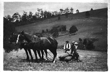
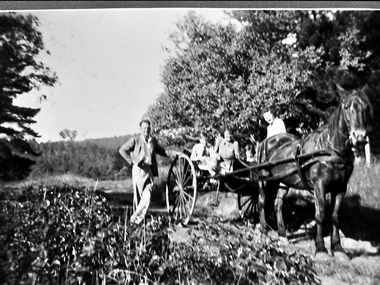
Photograph - Bringing in potatoes at Glen Park Farm, Selby, c.1913
B&W photo shows a two-horse team harnessed to a small sled which is laden with bagged-up potatoes. A man wearing dark hat, waistcoat and trousers and a pale shirt is holding the reins of the horses, and two people who could be the Johns children, Percy and Cissie, are seated on the potatoes. The paddock slopes away and another hillside rises in the background. This is most likely Black Hill. dated c.1913. -
 Southern Sherbrooke Historical Society Inc.
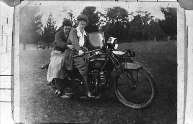
Photograph - Two women on a motorcycle
B&W photo shows Cissy Johns and friend on a motorbike at Glen Park Farm, Selby. The photo shows two women in their 20s or 30s, sitting on a motorbike with the registration number 12169. The woman on the right who is most likely Cissie, is sitting astride the bike, holding the handlebars. She is possibly wearing a peaked cap. She has a long knitted jacket over a pale blouse, and a medium coloured skirt which is rucked up by the bike's petrol tank, showing her right leg from the knee down. She has dark stockings and what appear to be medium-heeled, laced shoes with a high shine. The woman on the left is sitting sideways on the pillion seat, with her arms loosely around the first woman's waist. She is wearing a cloche-style hat, a dark knitted v-necked cardigan or jumper, a light-coloured, mid-calf-length skirt, dark stockings and dark shoes with large buckles. Her legs are crossed at the ankles. Both women are smiling at the camera. The windscreen of a sidecar is visible. They are in a cleared paddock with a wire fence and trees in the background. n.d. -
 Southern Sherbrooke Historical Society Inc.
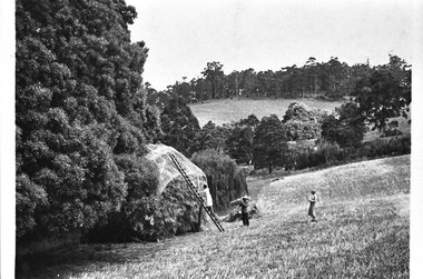
Photograph - Hay being stacked at Glen Park Farm, Selby
B&W photo showing hay being stacked at Glen Park Farm, Selby. The photo shows two women and a man in a sloping paddock. On the left is a woman in a pale, knee-length dress, climbing a ladder propped up against a tall haystack. The haystack has a covering with a repeated logo on it. A man stands near the bottom of the ladder, holding a sheaf of hay on his right shoulder. He is wearing a hat, light jacket and dark trousers. A woman stands uphill of the others. She has a light blouse and slightly darker calf-length skirt. The haystack is set between trees on the downhill side. In the distance Black Hill can be seen. -
 Southern Sherbrooke Historical Society Inc.
Photograph - Percy Johns, 1930s
B&W photo of Percy Johns, an unknown woman and a farm worker during potato digging at Glen Park Farm, Selby, in the 1930s. Percy Johns stands on the left, wearing a dark hat, jacket with deep pockets, and pants. He is holding a shovel in his right hand, and his left hand is on his hip. Beside him is a young unidentified woman with dark hair, who is wearing a loose dress with a drop waist. Beside her is an unidentified farm worker, wearing a hat, dark waistcoat and pants, and pale shirt. He has a pipe in his mouth. They are standing between rows of potatoes. On the left of the photo there is a row with potatoes lying on the ground. There are at least eight full bags of potatoes in the field. Behind the trio is what appears to be the cypress avenue running down to the homestead out of range on the right of the photo. -
 Southern Sherbrooke Historical Society Inc.
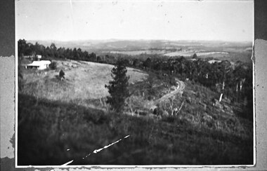
Photograph - Puffing Billy line near The Tanks
B&W photo of the Puffing Billy line near The Tanks below Glen Park Farm. On the left is the house of the Dunham family, with shedding in the background. The land slopes down to the track then falls quite steeply away to a treed area. In the distance can be seen land which is now part of Cardinia Reservoir. -
 Southern Sherbrooke Historical Society Inc.
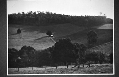
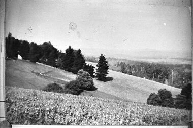
Photograph - Glen Park Farm, Selby
B&W photo showing Glen Park Farm, Selby, owned by the Johns family, as seen from the north-east corner. Photo shows the descent to the valley then up Black Hill in the background. Mostly cleared paddock apart from the cypress avenue to the farmhouse (which is glimpsed between the trees) a few single trees dotted about, and the heavily treed area on the top of Black Hill. There is a small building or shed or possibly a haystack in the centre of the photo. -
 Southern Sherbrooke Historical Society Inc.
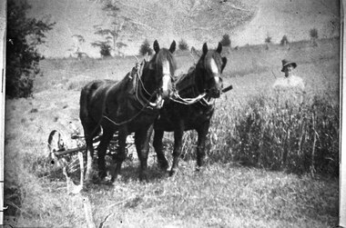
Photograph - Glen Park Farm, Selby
B&W photo shows two horses harnessed to a harvester or grass cutter. A worker dressed in pale shirt and hat stands to their left, behind chest-high grass. They are in a large paddock with trees dotted around. -
 Southern Sherbrooke Historical Society Inc.
Photograph - Glen Park Farm, Selby
B&W photo of Glen Park Farm taken from the eastern slope of Black Hill. -
 Southern Sherbrooke Historical Society Inc.
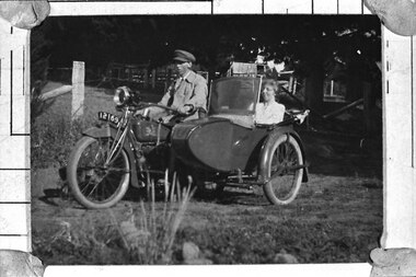
Photograph - Percy and Cissie Johns at Glen Park Farm
B&W photo of Percy and Cissie Johns at Glen Park Farm. Percy is astride a motorbike, reg # 12169, wearing a light coloured jacket over a shirt and tie, and wearing a peaked cap (similar to a uniform cap). Cissie is seated in the sidecar. She is wearing a light blouse and she is smiling. The sidecar has a folded-down roof and a windscreen. There are sheds and trees behind them. -
 Southern Sherbrooke Historical Society Inc.
Photograph - Adults and children with a horse and cart in Belgrave South, c.1940s
Black and white photo showing three adults and two children with a horse and cart. Mr Archibald William Muirhead, of 7 Colby Drive, Belgrave Heights (then called Glen Rd) stands to the left of the cart with his left hand resting on the wheel and his right hand on his hip. His left leg is crossed in front of his right leg. He is wearing a light-coloured suit. Sitting in the cart are two women and a boy and a girl. The girl is Pam Harris. They are on a dirt road with trees on either side. Behind them is a cleared area with more trees in the background. The photo was taken on Glen Road close to Monbulk Creek. On the back of the photo is printed '1627'. It probably dates to the 1940s and is part of a collection of family photos donated by Pam Harris, Shire of Sherbrooke President, 1982-1983 & 1987-1988. -
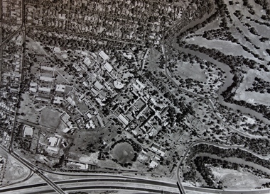 Kew Historical Society Inc
Photograph - Aerial Photograph, Aerial Photograph of Willsmere, circa 1980, c. 1980
This aerial photograph shows the Kew Cottages, and doctors/clergy residences on the north side of Wills Street, before the State Government sold the land for residential development. The doctors residences in Wills street were made of 'Glen Iris' Olympic Bricks. According to neighbours of the time most of the buildings were demolished overnight in the 1980s.Aerial photograph of Willsmere and the Kew Cottages bounded by the Boulevard, the Chandler Highway, Princess Street and Fellows Street. The roundabout at the intersection of Princess Street, Wills Street, and Eglinton Street is at the top left. The Eastern Freeway is at the lower edge of the photograph.kew cottages, eastern freeway, willsmere, yarra river, aerial photographs -- kew (vic), kew boulevard, willsmere mental hospital, kew mental hospital, kew childrens cottages -
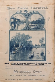 Kew Historical Society Inc
Programme, Kew Canoe Carnival, 1910
An item from an outstanding and diverse photographic collection, assembled by members of the Christian and Washfold families of Kew.Rare programme for what was once an annual event in Kew with important, possibly unique photos of sites in Kew and on the Yarra.Programme for the 1910 Kew Canoe Carnival which was held on the River Yarra on February 11th. The location was at the Asylum Reserve at the old white bridge (the precursor of Kane's Bridge). Funds were raised in Aid of the Annual Treat to Kew and Yarra Bend Patients (and the Carnival fund). The booklet includes details of the programme, numerous advertisements and rare and important historic photographs of the district including: the Willsmere Park Dairy, the Glen Tea Gardens at Hawthorn, the Pipe Bridge, the Kew Boat Sheds (Macauley's), and Rudder Grange boat house.christian-washfold collection, kew canoe club, kew canoe carnivals -
 Kew Historical Society Inc
Album - Photograph Album No.1, Henry Beater Christian, 1924-26
Henry Christian (c.1809-91), the grandfather of the photographer, was one of the first settlers in Kew. He arrived in Victoria with his wife Agnes and son Orlando in 1855 on the Gypsy Queen. He established a rope-making business in Bulleen Road by 1858 but was declared insolvent two years later. In his final years, he was celebrated as one of the oldest living settlers of the district. His son, Orlando Henry Beater Christian (c.1853-1930) became a member of the Hawthorn Band and a foundation member of the Willsmere Swimming Club. Orlando and his wife Elizabeth had four children of which Henry Beater Christian (1886-1962) was the oldest.An album of photographs, compiled by Henry Beater Christian (1886-1962) of Pakington Street, Kew, depicting individuals, natural and settled environments and the interactions between these worlds. Henry Christian, was a keen explorer, not just of his immediate environment but also of the Victorian wilderness. His major opus is contained in two albums in which he records, sometimes in majestic detail and on other occasions the intimate features of the natural world. His photographic travels during the 1920s, often in solitary ramblings but on other occasions with companions, recall the heroic landscape photography of an earlier era, pioneered by Nicholas Caire. In addition to their aesthetic value, the albums are historically significant records within the State of Victoria, of what is now a distant point in time, and of places that have become radically altered through human intervention.Digital copy of a 47-page photograph album containing 255 gelatinous silver images, loaned by Diane Washfold with permission given to digitise and hold a copy in our collection. The album contains a groups of photographic positives taken by Henry B Christian (a resident of Pakington Street), of places in Kew and throughout regional Victoria during the 1920s. The mainly sepia photographs, while small, are of a high resolution. Photographs are typically lightly glued onto pages. Locations are frequently identified by white or black ink, which in a number of cases is illegible due to wear.henry beater christian (1886-1962), landscape photography, photograph albums, kew (vic.) — yarra river, kew (vic.) — zig-zag bridge, kew (vic.) — macauley’s boathouse, studley park (vic.) — yarra river, wonderland — grampians (vic.), black spur (vic.), marysville (vic.), maroondah dam (vic.) — construction, warburton (vic.), cockatoo (vic.), bruthen (vic.), swan reach road (vic.), glen hills (vic.), lightning creek (vic.), omeo (vic.), glen wills (vic.), mt wills (vic.), sunnyside (vic), granite flat (vic.), toolangi (vic.), yea (vic, )., flowerdale (vic.), mt white law (vic.), baw baw (vic.), christian-washfold collection -
 Lilydale RSL Sub Branch
Book, Glen Wahlert, THE WESTERN/ Desert campaign 1940-41, 2006
Book -
 University of Melbourne, Burnley Campus Archives
Photograph - Black and white print, Glen Wilson, Australian Native Plants Under Mulch, Unknown
Note by E.B. Littlejohn 11 December 1991, "Glen Wilson submitted these photographs of his work using sawdust mulch, whilst attending Evening Classes."Black and white photograph with an envelope. View of an unmade road or drive with plants on each side surrounded by mulch.Envelope with caption, "Australian native plants under mulch ex Glen Wilson 334 Springvale Road Springvale 746-8824."native plants, glen wilson, sawdust mulch, evening classes -
 University of Melbourne, Burnley Campus Archives
Photograph - Black and white print, Glen Wilson, Natives, 15 Months After Planting at Merricks, Unknown
Black and white photograph. Photograph of plants surrounded by mulch.On reverse, "Natives, 15 months after planting at Merricks. Poor soil. Only tank water. 30 yrs old pine trees on this block (removed?) 18 months before photo taken. Ground mulched with 12" sawdust. Planted by "Schubert Method."merricks, pine trees, schubert method, natrive plants, sawdust mulch -
 University of Melbourne, Burnley Campus Archives
Photograph - Black and white print, Glen Wilson, Native Plants Growing in Sawdust Mulch, Unknown
Black and white photograph. Native plants growing in sawdust mulch. Native plants, well spaced, growing in area surrounded by 'paling' fence. Power line other side of fence.native plants, sawdust mulch, garden design -
University of Melbourne, Burnley Campus Archives
Document (item) - Masters and PhD Research papers, Anne Vale, 2005 - 2009
olive mellor (nee holttum), edna walling, emily gibson, c.b. luffmann, olive pink, peter valdor, margaret hendry, alistair knox, david glen, tom garnett, kevin heinze, jean galbraith, , bill mollison, betty maloney, jean walker, george seddon, diana snape, joan law-smith, thomas shepherd, john turner, john stevens, william sangster, paul sorensen, ellis stones, margaret darling, sophie ducker, mervyn davis, jocely brown, beatrice bligh, grace fraser, peter cundall, gordon ford, fiona brockhoff, clive blazey, masters thesis, phd thesis -
 City of Kingston
Photograph - Digital image
Sepia toned digital image of Isabella Macdonald nee Munroe (1820-1906) Born in Skye, Scotland, Isabella arrived in Melbourne on the 'Glen Huntly' on April 17, 1840. She died at Cranbourne in 1906.Isabella Munroe travelled to Australia with her mother, travelling under her maiden name of Mary McKenzie, on the Glen Huntley, arriving in the Port Phillip District 17 April 1840. The Glen Huntley arrived flying the yellow quarantine flag indicating it was carrying passengers with infectious diseases. Of a passenger complement of 170 passengers, during the voyage 105 contracted various diseases including fever, scarlatina, measles, small pox, and chicken pox. Both Mary and Isabella were held for a period in the camp at Little Red Bluff or Red Cliffs, known today as Point Ormond. Isabella married Alexander Macdonald at Scots Church, Melbourne on 17 February 1841. After their marriage they started the sheep run named Stringy Bark, on the Yarra, near where Kew is today. Sepia toned digital image of Isabella Macdonald standing beside a table. -
 Eltham District Historical Society Inc
Photograph - Digital Photograph, Marguerite Marshall, Strathewen Public Hall, 20 August 2008
Strathewen Public Hall, social and spiritual centre was later lost in the Black Saturday fires 2009. The Strathewen Community decided a community hall was needed in 1901. In 1902 locals built the hall with messmate trees. It was located on the Cottlesbridge-Strathewen Road. The first function was a Grand concert and Balll attended by about 120 people. Several denominations held Church services and Sunday School services in the Hall. It survived several bushfires until after this photo was taken when it was destroyed in Black Saturday, 9 February 2009. Published: Nillumbik Now and Then / Marguerite Marshall 2008; photographs Alan King with Marguerite Marshall.; p89 Strathewen was settled late, largely because it was difficult to access.1 Early selectors found it a struggle to survive. They had to do everything themselves, from felling trees for buildings, to taking produce to market along bush tracks that they had helped cut. Small dairy farms were typical but fruit became the district’s prime produce. The first settlers east of Arthurs Creek were brothers John and Duncan Smith whose station Glen-Ard was probably operated as a sheep run. Other early settlers were the Mann family, who were to donate land for the hall, provide postal services and John Mann was an Eltham Shire councillor from 1916 to 1919.2 In 1873 James Mann, his wife Jane and their six children, settled on 207 acres (83.7) (Lang Fauld Farm) on both sides of Eagles Nest Road, from the foot of Mount Sugarloaf to the bank of the Arthurs Creek. In 1883 James took up another selection on Chads Creek. It was very hard work and at times he was well behind with his rent. However the family had a good social life, attending the Primitive Methodist Church at the Arthurs Creek Township and on New Year’s Eve throwing a party for all the locals. By 1874 James Mann’s younger brother, John, selected 311 acres (125.8ha) between Eagles Nest Road and upper Arthurs Creek. He called it Carseburn after his home parish in Scotland. Tragically in 1875 John drowned in the Yarra River, at Richmond.3 John Mann’s oldest son, also John, later purchased Duncan Smith’s land, which he named Violet Glen. He was to give one acre (0.4ha) of this land for the Strathewen Hall site. A Mann family diary written at Carseburn in 1897, tells how the district’s name was selected. Strathewen is derived from ‘strath’ meaning ‘broad mountain valley’ and from the name of Ewen H. Cameron, the local parliamentarian for almost 40 years. ‘George Brain came around to get a petition signed to get a post office up here and we had to vote for a name—Strathewen, Glen-Ard, or Headcorie’.4 It was at Carseburn that a public meeting in 1901, decided to build the Strathewen Hall on the Cottlesbridge-Strathewen Road. In 1902 the locals built the hall with messmate trees. The first function was a Grand Concert and Ball attended by around 120 people and several Protestant denominations took turns to hold church services and Sunday School there. Fortunately the hall has survived bushfires to be the town’s spiritual and social centre.5 The area continued to develop and in 1909 a post office operated somewhere at Strathewen and from around 1916 at Carseburn.6 It was not until 1914 that land was bought to establish the Strathewen State School on School Ridge Road. The residents paid £100 to build it on two acres (0.8 ha) while the Education Department contributed £30 and leased the building annually for £1. When teacher Miss Mary Golding opened the school in 1917, it had no equipment.7 But in 1921 the Education Department provided desks and a hexagonal shelter shed (now a rare style in Victoria) and took control in 1925.8 By 1917 Strathewen was booming.9 George Apted had built a coolstore in 1916, and local orchardists bought storage space until the 1950s. This allowed the area to supply the market in and out of season. Guesthouses catered for growing tourism. In the mid 1920s Mrs Eleanor Sparkes built the guest-house Singing Waters, which operated through the 1930s. Her daughter Mrs Vera McKimmie, ran it until the 1950s and the house remains in Chads Creek Road. In the Great Depression land was cleared for timber to be sold as firewood and there was small scale sawmilling. However the orchard industry diminished for several reasons including the 1939 bushfires and rapid changes in production methods. Today the Apteds still operate an orchard and farm at Glen-Ard, which straddles the border between Strathewen and Arthurs Creek. It includes the southern part of Duncan Smith’s original Glen-Ard selection.This collection of almost 130 photos about places and people within the Shire of Nillumbik, an urban and rural municipality in Melbourne's north, contributes to an understanding of the history of the Shire. Published in 2008 immediately prior to the Black Saturday bushfires of February 7, 2009, it documents sites that were impacted, and in some cases destroyed by the fires. It includes photographs taken especially for the publication, creating a unique time capsule representing the Shire in the early 21st century. It remains the most recent comprehenesive publication devoted to the Shire's history connecting local residents to the past. nillumbik now and then (marshall-king) collection, strathewan public hall -
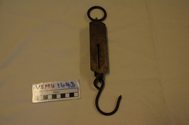 Emerald Museum & Nobelius Heritage Park
Orchadist Scales, Donated by Frank Eckerman (Emerald)
Used in orchards by Harry Shaw (Orchardist in Springvale Rd, Glen Waverley near cnr Highbury Road) Orchard was sold in 1950. Later used on poultry farm in Forest Hills.Body of scales: brass plate inscribed - Salter Pocket Balance, made in England. No.3. To weigh 50LB. Slide measure 0 to 50. Pattern at top: twisted rope with arrow through middle. Reverse side: green painted metal. Hanging metal ring at top end and metal hook at lower end. Salter Pocket Balance, Made in England. No.3. To weigh 50LB. -
 Melbourne Tram Museum
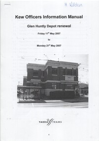
Manual, Yarra Trams, "Glen Huntly Depot Renewal", "Kew Depot - Pit Deepening Roads 1 to 4", "Camberwell Depot Yard Tracks Renewal", 2007 to 2011
Set of three Reports or Operations Plan or Manual for work at Kew and Glen Huntly Depots. .1 - 12 A4 pages - stapled - "Kew Officers Information Manual - Glen Huntly Depot renewal" - Friday 11 May 2007 to Monday 21st May 2007". Has a photo of the depot on the front sheet. Covers service changes, arrangements for changes to services running from Kew Depot, car parking, tram requirements. Has a table of contents. .2 - 7 A4 pages - stapled - "Operations Plan - "Kew Depot - Pit Deepening Roads 1 to 4" = Monday 23 June 2008 to Friday 18 July 2008" - has a table of contents, covers maintenance, tram requirements, out stabling, security, sanding and hours of operation. .3 - 19 A4 pages - stapled - "Camberwell Depot Yard Tracks Renewal" - Saturday 3 December 2011 to Monday 12 December 2011 - has a table of contents, service changes, car parking, stabling, maintenance, operations, sanding, cleaning, rosters and test trams and notice to employees. .4 - 3 A4 foolscap sheets - Co-ordinating plan for Kew Depot / Barkers Road entrance and High Street and Cotham Road - dated 25/11/2005 - list works, location, overhead, cabling, track and other works and isolation requirements. On the rear has a list of the trams for the depot, Collins St, Simpson St and Camberwell. .5 - Notes on the Kew Depot relay by Hugh Waldron received in an email dated 9/3/2018 - from Kew Depot History..1 - Has "H. Waldron" in top left hand corner in blue ink. .2 - ditto "Hugh" in red ink.trams, tramways, yarra trams, kew depot, glenhuntly tram depot, trackwork, depot fan, tram services -
 Melbourne Tram Museum
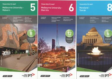
Ephemera - Tram Route Guides, Public Transport Victoria (PTV), "Tram Route Map", 1/2015 and 6/2015
Set of 7 Tram Route Maps, published during 2015. Each comprises a vertical DL folded sheet, full colour for the nominated routes, with Yarra Trams and PTV logos, listing the stops, interchanges with bus and other tram services, ticketing zones, estimated frequencies with adverts for Night tram services, TramTracker and Myki tickets. .1 - Route 5 - Melbourne University to Malvern .2 - Route 6 - Melbourne University to Glen Iris .3 - Route 8 - Moreland to Toorak .4 - Route 11 - West Preston - Victoria Harbour Docklands .5 - Route 19 - North Coburg - Flinders St Station .6 - Route 70 - Wattle Park to Waterfront City Docklands .7 - Route 72 - Melbourne University to Camberwell .8 - Route 1 - East Coburg - South Melbourne Beach .9 - Route 3 and 3A - Melbourne University to East Malvern .10 - Route 16 - Melbourne University to Kew .11 - Route 55 - West Coburg - Domain Interchange .12 - Route 57 - West Maribyrnong - Flinders St Station .13 - Route 59 - Airport West - Flinders St. Station .14 - Route 64 - Melbourne University - East Brighton .15 - Route 67 - Melbourne University - Carnegie .16 - Route 78 - North Richmond - Balaclava via Prahran .17 - Route 82 - Footscray - Moonee Ponds See Reg Item 2396 for 2012, 2278 for 2016 and 2940 for 2014 versionstrams, tramways, timetables, maps, route 1, route 3, route 5, route 6, route 8, route 11, route 16, route 19, route 55, route 57, route 59, route 64, route 67, route 70, route 72, route 78, route 82, east coburg, south melbourne, east malvern, kew, west coburg, west maribyrnong, airport west, east brighton, carnegie, north richmond, balaclava, footscray, moonee ponds, malvern, glen iris, moreland, west preston, north coburg, wattle park, camberwell -
 Melbourne Tram Museum
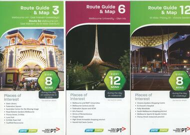
Ephemera - Tram Route Guides, Public Transport Victoria (PTV), "Tram Route Guide and Map", Oct. 13 to July 14
Set of 17 Tram Route Maps, published during 2013 and 2014. Each comprises a vertical DL folded sheet, full colour for the nominated routes, with Yarra Trams and PTV logos, listing the stops, interchanges with bus and other tram services, ticketing zones, estimated frequencies with adverts for Night tram services, TramTracker and Myki tickets. .1 - Route 3 - East Malvern - Melbourne Uni and 3A via St Kilda (Sat and Sun) .2 - Route 6 - Melbourne University to Glen Iris .3 - Route 12 - St Kilda - Victoria Gardens .4 - Route 16 - Kew via St Kilda .5 -Route 30 - St Vincent's Plaza - Etihad Stadium .6 - Route 55 - West Coburg - Domain Interchange .7 - Route 59 - Airport West - City (Elizabeth St) .8 - Route 64 - Melbourne University - East Brighton .9 - Route 70 - Wattle Park to Waterfront City Docklands .10 - Route 75 - Docklands - Vermont South .11 - Route 78 - North Richmond - Balaclava .12 - Route 82 - Moonee Ponds - Footscray .13 - Route 86 - Bundoora - Waterfront City .14 - Route 96 - East Brunswick - St Kilda Beach .15 - Route 109 - Box Hill - Port Melbourne .16 - Route 112 and 11 - West Preston - St Kilda and West Preston - Victoria Harbour Docklands .17 - Route 24 - North Balwyn to Etihad Stadium See Reg Item 2396 for 2012, 2278 for 2016 and 2939 for 2015 versionstrams, tramways, timetables, maps, route 3, route 6, route 11, route 12, route 16, route 24, route 30, route 55, route 59, route 64, route 70, route 75, route 78, route 82, route 86, route 96, route 109, route 112, east malvern, glen iris, victoria gardens, kew, st vincent's plaza, west coburg, airport west, east brighton, wattle park, vermont south, north richmond, moonee ponds, footscray, st kilda, docklands, west preston, victoria harbour, north balwyn, etihad stadium