Showing 10832 items
matching maps
-
 Beechworth RSL Sub-Branch
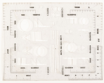
Stencil Warfighting Symbology
This instrument would sit in a field book for the purpose of drawing maps.Clear plastic stencil - Warfighting Symbology - featuring various measurements and ratios in black including a NATO stock number.NATO stock number: 6675-66-023-8677instrument, field book, template field, stencil -
 Bendigo Historical Society Inc.
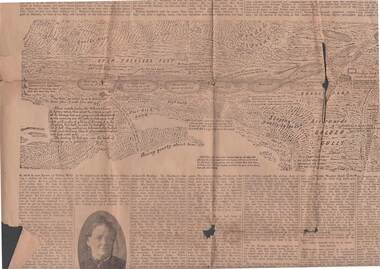
Newspaper - 1911 BENDIGO ADVERTISER, 14th July, 1914
( x ref 5673 , 8235 , Box 83 , 9077 ) Page 5 and 6 from the Bendigo Advertiser Friday July 14 1911. 1851 discovery of gold significant portion. Part of G Mackay 'Annals of Bendgo'Page 5 has an article titled Annals of Bendigo ''-the first article under this heading was published in the Bendigo Advertiser on 7th July .Included are Cameo photos of Messrs Johnson , Fenton , Sandbach , Frencham and Mrs Kennedy together with an early sketched map of the Bendigo Goldfields . Within the article is a mention of the sketched map as follows - '' The accompanying map was drawn from memory by W. Sandbach who lived a month in the Mia mia (22nd November to 19th December 1851 ) …The map was laid before the Frencham committee at the inquiry. The map shows geographical features such as 'Gentle Rise , Wooded pointbendigo, gold mining, bendigo discovery -
 Ballarat Tramway Museum
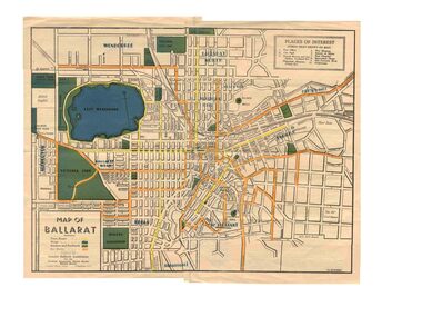
Map, Greater Ballarat Association and George Netherway, "Map of Ballarat", c1945
Yields information about Greater Ballarat, including trams, buses, locations and streets. Has a strong association with George Netherway.Five colour map of Ballarat, showing streets, places of interest, Parks, tram routes, bus routes, railway lines, prepared by G. C. Netherway, Greater Ballarat Association, for the Victorian Government Tourist Bureau, Ballarat Branch, c1945. Shows suburbs names, location of orphanage, the lack of development north of Howitt St, in Wendouree. Map is part diagrammatic and is not entirely to scale. On rear is a road map of the Ballarat area, lists of statistics, beauty spots, look outs, art and culture, points of historical interest, industrial products and recreation. Note: Image 1, assembled from four scans, does not entirely match at edges. See Reg item 2074 for photographic image of another version map. See Reg Item 5613 for another version of this map. trams, tramways, ballarat, tram routes, bus routes, map, lists -
 Warrnambool and District Historical Society Inc.
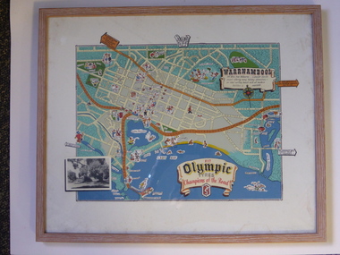
Advertising, Tourist Map of Warrnambool (framed x 2), 1950s
These framed tourist maps came from the Lane Foundation so it is presumed that they were from the office of Lane’s Travel Service which operated from 205 Raglan Parade Warrnambool with the known dates, the 1950s and 1960s. The proprietor, Alan Lane, was a successful Warrnambool businessman who operated a Warrnambool and district bus service as well as his travel business. He was heavily involved in local community affairs being a Warrnambool Councillor for 18 years from 1952 to 1970 and President of the Warrnambool Chamber of Commerce for six years. He was a major donor to the Warrnambool Performing Arts Centre, the Warrnambool Art Gallery and the St. John of God Hospital and left the bulk of his estate to the Alan Lane Foundation which has contributed millions of dollars to local organizations and programs. Alan Lane died in 1995. These framed maps are of some interest as examples of the tourism maps used to promote the city and district in the 1950s and 60s. This is a tourist map of the Warrnambool C.B.D. and adjoining streets produced as an advertisement for Olympic Tyres. It is multi-coloured and has cartoon sketches of the main tourist attractions and pointers to attractions outside of the main city area. It includes an inset black and white photograph of the Warrnambool Botanic Gardens and an advertisement for Olympic Tyres. It is printed on a white background and is enclosed behind glass in a wooden frame of a light brown colour. It has a wire at the back for attachment to a wall. ‘Warrnambool – 163 miles from Melbourne – a popular tourist resort offering many holiday attractions – an ideal surfing beach with all modern facilities is avalable’ ‘Fit Olympic Tyres, Champions of the Road’ alan lane foundation, warrnambool tourism -
 Bendigo Military Museum
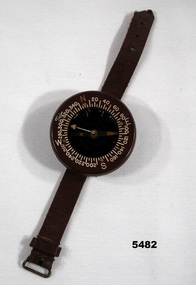
Equipment - COMPASS
... maps ...Wrist mounted flying compass worn by Flight Lieutenant Ian A. Lyons. Part of Flight Lieutenant Ian A. 'Joe' Lyons MBE Collection. See Catalogue No. 5374P for his service record.Circular faced brown bakelite flying compass with rotating dial. Degrees and NSEW marked on the dial. The direction needle is suspended in liquid. Brown leather strap with buckle for attaching to wrist.Stamped on the back: 'US ARMY COMPASS, WRIST. LIQUID FILLED, TAYLOR MODEL'.flying compass, equipment, navigation equipment, maps, flight lieutenant ian a. lyons -
 Whitehorse Historical Society Inc.
Map, The Parish of Nunawading, 1853
... Maps ...Photocopy of manuscript plan with allotments numbered and some named.Photocopy of manuscript plan with allotments numbered and some named. Note on verso: The Parish of Nunawading in the County of Bourke; lithographed at the Surveyor General's office by J.Jones Jan 18th 1853. Endorsed Sale Plan 271. Dray tracks, water holes and terrain indicated.Photocopy of manuscript plan with allotments numbered and some named. land subdivision, maps, parish of nunawading, jones, j -
 Ballarat RSL Sub-Branch Inc.
Map - New Guinea
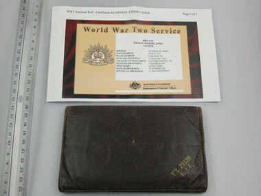
... Maps ...This object relates to Ernest Joseph LEWIS. He was born on 20/05/1911 in Carlton, VIC. Ernest Joseph served in the Army (VX73578) enlisting on, 27/01/1942 in West Brunswick, VIC before being discharged from duties with the 15 FLD REGIMENT as a Army Non-Commissioned Private (PTE) on 03/10/1945. Ernest Joseph LEWIS was not a prisoner of war. His next of kin is Ethel LEWIS.Found in wallet (455)second world war (ww2), 1939 - 1945, maps, ballarat rsl, ballarat -
 Ballarat RSL Sub-Branch Inc.
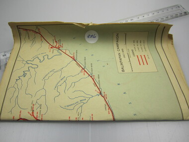
Maps (2)
... Maps ...Balikpapan Campaign, Bougainville Campaignsecond world war (ww2), 1939 - 1945, maps, ballarat rsl, ballarat -
Ballarat RSL Sub-Branch Inc.
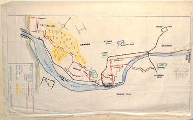
Map - Japanese
... Maps ...second world war (ww2), 1939 - 1945, maps, ballarat rsl, ballarat -
 Ballarat Tramway Museum
Drawing - Map or Plan, Wanganui Tramways NZ, 1945
... Maps ...Wal Jack had an extensive range of correspondents throughout Australia and the world who often provided him with detailed drawings and notes on various tramway systems. Drawing shows the various lines both railways and tramways, crossing loops, locations and features of the Wanganui NZ tramway system in 1945. Drawn by an unknown person; has an initial in the bottom right hand corner.Yields information about Wal Jack's correspondents and their extensive work.Drawing - red and black ink, colour pencil on foolscap paper of Wanganui Tramways NZ 1945letters, wal jack, drawings, maps, wanganui nz -
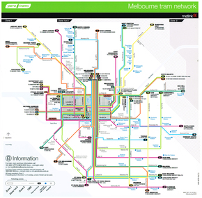 Melbourne Tram Museum
Poster, Yarra Trams, "Melbourne Tram Network", Apr. 2011
... Maps ...Full colour poster printed on a vinyl plasticized based sheet titled "Melbourne Tram Network. Shows a diagrammatic layout of the Melbourne tram system, shows zones, CBD, tram terminuses, train station and hospitals. Has the Yarra Trams and Metlink logos. Provides contact information including a website. Dated Effective April 2011. See also Reg item 721 for Jan. 2014 version. 2 copies held.trams, tramways, yarra trams, metlink, maps -
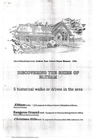 Eltham District Historical Society Inc
Document - Folder, Historical Walks, 1993
Includes: Eltham Festival 1992, Eltham Discovery Walks: 3 walks with short descriptions. "Kangaroo Ground Historical Notes" with points of interest highlighted for a walk or drive and map titled "Tour maps, Christmas Hills, 1992" with points of interest highlighted - and cover sheet 7 pages. Photocopiestour, walk, christmas hills, kangaroo ground, little eltham, eltham festival, armstrong, barr, bell, donaldson, harkness, harry gilham collection, jardine, johnson, mess, rogerson, ross, stevenson, thompson, walters, weller, whipple -
 Robin Boyd Foundation
Document - Script, Robin Boyd, The Flying Dogtor. Episode 39 The Second Clue, 1963
The Flying Dogtor and the bush children followed the clues on a mysterious map leading to a bushranger's buried treasure. Crafty Carson Carpetbag and Old Man Redback stole the map and separately worked out its message. Then they set out to find the treasure ahead of The Flying Dogtor.The Flying Dogtor" series was broadcast on Australian Television Network (later becoming the Seven Network) between February and April 1964 (see item D254 for schedule).Typewritten, carbon copy, foolscap, 2 pagesPage 1: handwritten pencil addition, left hand sidethe flying dogtor, robin boyd, crawford productions, manuscript -
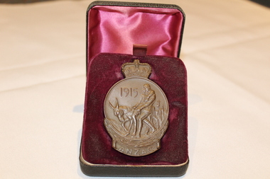 Dandenong/Cranbourne RSL Sub Branch
Medal - ANZAC 1915 Medalion, Unknown
WWI Historical significanceANZAC medallion with crown on top and Simpson and his donkey engraved on the medalion1915, ANZAC on one side with a map of Australia and New Zealand with the Southern Cross engraved on the other. The name E. Bourke is engraved on the bottom. -
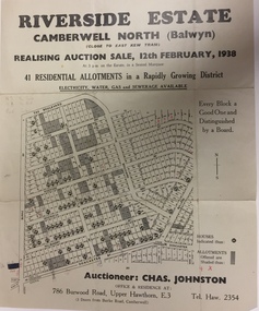 Kew Historical Society Inc
Plan - Subdivision Plan, Riverside Estate, Camberwell North (Balwyn), 1938, 1939
This subdivision known as the Riverside Estate wa sone of the largest and most significant in Balwyn's history.Subdivision Plan for 41 lots within the wider Riverside Estate in Camberwell North, now Balwyn, in February 1938. The auction featured lots in Burke Road, The Boulevard, Mt View Road, Wattle Avenue, Kyora Parade, Cascade Street, Riverside Avenue, Walbundry Avenue, Inverness Way, Bulleen Road and Doncaster Road.Allotments for sale are shaded grey on the map. Certain lots have an H in a circle. These are presumably where houses had already been constructed.subdivision plans - balwyn (vic), riverside estate - balwyn (vic) -
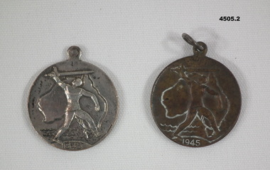 Bendigo Military Museum
Memorabilia - VICTORY MEADALLION 1945, c.1945
.1) .2) Medallion, metal, circular with a section at top for a ring, front face has depiction map of Australia with a figure holding a sword overhead, year date at bottom, rear has a styalized map of the World, , a small depiction of a boat, whale, writing stamped in.On front, "1945", on rear, "Victory Medal"medallions, victory 1945 -
 Dunkeld Museum Inc.
Coat, Flying, During World War 1
This coat was owned and worn by Lieutenant T L(known as Leigh) Simpson D.F.C. who joined the Royal Flying Corps during Workd War 1. He was born in Hamilton Victoria and had an interest through his family in flying, before the war. In 1916 he transferred from the Light Horse Field Ambulance to the 68th Australian Sqd. Royal Flying Corps. He was promoted to lieutenant of the 3rd Squadron. During the war he was a pilot and photographer and took hundreds of reconnaissance photos over occupied territory. He was involved in photographing enemy positions and supplying information to the artillery batteries which then shelled those positions. He was involved in a number of missions involving direct contact with the enemy including Baron von Richtofen and was involved in the "dog fight" which led to von Richtofen's death. In May 1918 he had been promoted to Flight Commander and temporary Captain when his cousin Captain Duigan was wounded. He represented Australia at von Richtofen's funeral and presented the Australian wreath. Following his discharge after being seriously wounded, he returned home and became a grazier in the Dunkeld area. He maintained his interest in aviation throughout his life with a strong connection with Reg Ansett and was a director of Ansett Airways Pty Ltd for many years. He died in Dunkeld in 1960This flying coat is significant because it was owned by Lieutenant Thomas Leigh Simpson DFC while he was in the Australian Flying Corps during World War 1. World War 1 Flying coat. Tan leather, nap finish. Lining wool fabric. Map pocket on front of chest. Internal pocket on left front behind map pocket and external pocket below the waist on the left hand front towards the side.L Simpson on the inside left front.t leigh simpson, royal flying corps, baron von richtofen, australian aviation -
 Kiewa Valley Historical Society
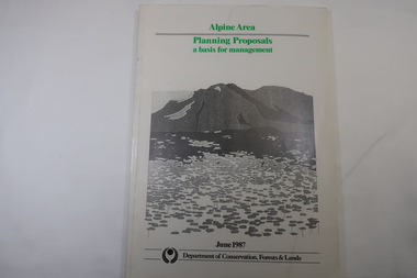
Book - Book - Alpine Area - Department of Conservation, Forests & Lands, Alpine Area / Planning Proposals / a basis for management. 1987
It is the policy of the Government that most of the State's alpine area will be proclaimed as an Alpine National Park, which would complement the Kosciusko National Park in N.S.W.. This is yet to be achieved (1987), however there is a need for sound, efficient and coordinated management based on the area's natural features, values and uses. Planning is proceeding on this basis.Victoria's alpine area is one of the State's most outstanding and spectacular natural areas. It is noted for its diverse plant and animal life, scenery, recreation opportunities and as a water catchment. This country is at the upper end of the Kiewa Valley and the planning for it is of interest to the Kiewa Valley inhabitants.White bound book with green print for title at the top, black & white picture and black print at the bottom for the name of the government authority publishing the book.143 pages with fold out map after page 7. The map is coloured green to indicate the planning area.alpine area, bogong national park, victorian department of conservation forests & lands -
 Federation University Historical Collection
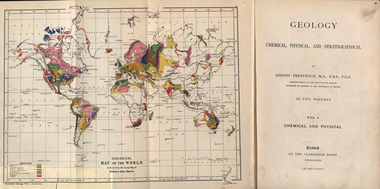
Book, Geology, Chemical, Physical, and Stratigraphical, 1886
These books were added to the library of the School of Mines Ballaarat in 1889. The author was Joseph Prestwich, who was a Professor of Geology at the University of Oxford.Two brown hard cloth covered books, Vol 1 & vol 2 with gold printing on the front cover and on the spine. .1) has a coloured fold out map of the World opposite the title page .20 has a coloured fold out map of Europe..1) A label is attached to the inside front cover with The School of Mines Ballaarat and the no. 955 and date purchased 14/3/89 (1889) as well as the institutions stamp in several places throughout the book. .2) As above but with no. 956 and on the inside fly is written in pencil 'Stamped in Error' with a Ballarat School of Mines Student Library stamp crossed out.geology, bookplate, library plate, ballarat school of mines library, joseph prestwich, geological map of the world, geological map of europe, hieropolis thermal springs, rockss, ice, volvanoes, earthquakes, metallurgy, shakespeare's cliff dover, wapley, gloucestershire, redruth mining district, fossils, reptilian footprints, chalk, london clay -
Bendigo Historical Society Inc.
Map - LYELL : COUNTY OF BENDIGO, 24-10-84
Map. Lyell, County of Bendigo, Eppalock, Sedgwick, Sutton Grange, Hawkestone, Kimbolton, Coliban River, Myrtle Creek. State School. Photo-Lithographed at the Department of Lands and Survey, Melbourne by J. Noune, 24-10-84. (number 71 in map cupboard 1)J. Nounemap, bendigo, lyell -
Bendigo Historical Society Inc.
Map - LYELL : COUNTY OF BENDIGO, 24-9-07
Map. Lyell, County of Bendigo, Sedgwick, Sutton Grange, Hawkestone, Kimbolton, Eppalock, Myrtle Creek, Coliban River. Photo-Lithographed at the Department of Lands and Survey, Melbourne by T.F. McGauran, 24-9-07, Price 1/-. (number 70 in map cupboard 1)T.F. McGauranmap, bendigo, lyell -
Bendigo Historical Society Inc.
Map - LOCKWOOD : COUNTY OF BENDIGO, 2=7-18
Map. Lockwood, County of Bendigo. Marong, Shelbourne, Ravenswood, Mandurang. Photo- Lithographed at the Department of Lands and Survet, Melbourne by W.J. Butson 2-7-18. By authority A.J. Mullett, Government Printer, Melbourne. Price 1/-. (number 69 in map cupboard 1)A.J. Mullett, Government Printer, Melbourne.map, bendigo, lockwood -
Bendigo Historical Society Inc.
Map - LEICHARDT : COUNTY OF BENDIGO, 15-6-19
Map. Leichardt, County of Bendigo, Bridgewater, Yarraberb, Nerring, Marong, Woodstock, Derby, Sandhurst & Inglewood Railway Line. Photo-Lithographed at the Department of Lands and Survey, Melbourne, by T.F. McGauran, 15-6-09. Price 1/-. (number 68 in map cupboard 1)T.F. McGauranmap, bendigo, leichardt -
 Bendigo Historical Society Inc.
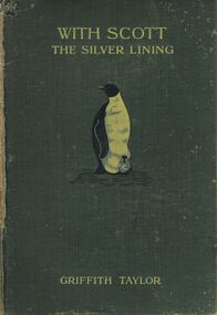
Book - WITH SCOTT: THE SILVER LINING
A damaged hard covered book titled 'With Scott : the Silver Lining.' by Griffith Taylor.'With nearly 200 illulstrations and maps.' An illustration of a penguin and chick is on the front cover. London. Smith, Elder & Co. publishers, 15 Waterloo Place. 1916. 448 p. (ill., maps,)Griffith Taylorbooks, biography, captain scott, books, exploration, adventure, antarctica, people, person, famous people, captain robert falcon scott -
Bendigo Historical Society Inc.
Map - YARRAYNE : COUNTY OF BENDIGO, 6-1-32
Map. Yarrayne, County of Bendigo, Janiember Easr, Pompapiel, Salisbury, Bridgewater, Salisbury West, Powlett. Photo-Lithographed at the Department of Lands and Survey, Melbourne. Price 2/-. 6-1-32.By authority H.J. Green, Govt.Printer. (number 31 in map cupboard 1)H.J. Green, Govt.Printer.map, bendigo, yarrayne -
Bendigo Historical Society Inc.
Map - WANURP : COUNTY OF BENDIGO, 1-12-33
Map. Wanurp, County of Bendigo, Terrick Terrick East, Pannoobamawm, Milloo, Dingee, Mitiamo. Photo-Lithographed at the Dept. of Lands and Survey, Melbourne. Price 1/-. 1-12-33. By authority H.J. Green, Govt. Printer. (number 26 in map cupboard 1)H.J. Green, Govt. Printermap, bendigo, wanurp -
Bendigo Historical Society Inc.
Map - CORNELLA : COUNTY OF BENDIGO, 18-3-08
Map. Cornella, County of Bendigo, County of Rodney, Colbinabbin, Gobarup, Redcastle, Toolleen, Cornella Creek, Kangaroo Creek. Photo-Lithographed at the Department of Lands and Survey, Melbourne by T.F. McGauran. 18-3-08. Price 1/-. (number 122 in map cupboard 1)T.F. McGauranmap, bendigo, cornella -
Bendigo Historical Society Inc.
Map - TALAMBE : COUNTY OF BENDIGO, January 1956
Map. Talambe, County of Bendigo, Hayanmi, Dingee, Tandarra, Yallook, Pompapiel, Calivil. Drawn and reproduced at trhe Department of Lands and Survey, Melbourne. January 1956. Price 2/-. By authority W.M. Houston, Government Printer, Melbourne. (number 23 in map cupboard 1)W.M. Houston,Government Printer, Melbourne.map, bendigo, talambe -
Bendigo Historical Society Inc.
Map - WELLSFORD : COUNTY OF BENDIGO, 15-12-41
Map. Wellsford, County of Bendigo, Bagshot, Ellesmere, Axedale, Strathfieldsaye, Huntly, Sandhurst. Drawn and reproduced at the Dept. of Lands and Survey, Melbourne.15-12 41. Price 2/-. By authority H.E. Daw, Government Printer, Melbourne. (number 20 in map cupboard 1)H.E. Daw, Government Printer,Melbourne.map, bendigo, wellsford -
Bendigo Historical Society Inc.
Map - DERBY : COUNTY OF BENDIGO, 1-9-09
Map. Derby, County of Bendigo, Inglewood, Loddon River, Tarnagulla, Woodstock, Leichardt, Bridgewater, Bendigo to Inglewood Railway. Photo-Lithographed at the Department of Lands and Survey, Melbourne, by T.E. McGauran 1-9-09. Price 1/-. (number 55 in map cupboard 1)T.E. McGauranmap, bendigo, derby