Showing 10834 items
matching maps
-
 Bendigo Military Museum
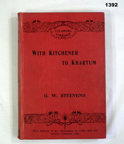
Book, William Blackwood and Sons, With Kitchener to Khartum, 1901
Volume 3 of The Works of George Warrington Steevens.Red buckram cover with title in black letters. 326 pages with cut edges. Contains coloured maps.Inside on 2nd page: Percy H Morcom 26.1.'02 from A.M. with many happy returnsbooks - history, military -
 Marysville & District Historical Society
Ephemera (Item) - Advertising brochure, Buxton Trout & Salmon Farm, Unknown
An advertising brochure for Buxton Trout and Salmon Farm in Victoria.An advertising brochure for Buxton Trout and Salmon Farm in Victoria. Buxton Trout and Salmon Farm was established in 1958 and is Australia's first commercial trout farm where trout have been reared for over 50 years.buxton, victoria, buxton trout and salmon farm, advertising brochure, brochure, trout, salmon -
 4th/19th Prince of Wales's Light Horse Regiment Unit History Room
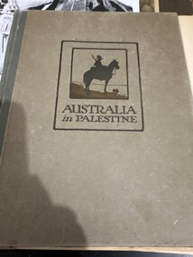
Book, Angus & Robertson Ltd, Australia in Palestine, 1919
Hard covered book. Stories of the Australians' campaign in Palestine in World War 1, with photos, drawings and mapsaustralian military history, palestine -
 Phillip Island and District Historical Society Inc.
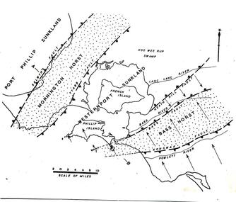
Sketch
One of a collection of over 400 sketches & photographs in an album commenced in 1960 and presented to the Phillip Island & Westernport Historical Society by the Shire of Phillip IslandSketch Map of Westernport region and environs showing physiographical faults and warps. Drawn by Dr G Bakerlocal history, illustrations, pen & ink, westernport region, black & white sketch, physiography, dr g baker, e s hill d.sc, john jenner, bryant west -
 Greensborough Historical Society
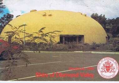
Book, The Shire of Diamond Valley Handbook 1981, 1981_
Guide to services provided by Shire of Diamond Valley. The Shire of Diamond Valley was a Local Government Area located about 20 kilometres northeast of Melbourne. The shire covered an area of 74.38 square kilometres and existed from 1964 until 1994.Annual guide to services in Shire of Diamond Valley28 pages, col illus., maps. Cover illustration of "Diamond Creek Bini-shell". (2 copies)shire of diamond valley, greensborough, handbooks -
 Greensborough Historical Society
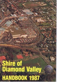
Book, Shire of Diamond Valley Handbook 1987, 1987_
Guide to services provided by Shire of Diamond Valley. The Shire of Diamond Valley was a Local Government Area located about 20 kilometres northeast of Melbourne. The shire covered an area of 74.38 square kilometres and existed from 1964 until 1994.Annual guide to services in Shire of Diamond Valley32 pages, col illus., maps. Cover illustration of aerial view of Greensborough shopping area and environs.shire of diamond valley, greensborough, handbooks -
 Greensborough Historical Society
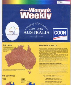
Poster, Centenary of Federation 1901-2001 Australia, 2001_
Celebrating the centenary of Federation, this poster also lists Prime Ministers from 1901 to 2001.Poster with colour map Scale 1: 6,440,000 and list of Australian Prime Ministers, printed one sideaustralia federation, prime ministers - australia -
 Greensborough Historical Society
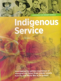
Book, Indigenous Service: a resource book for primary schools, 1914o
This volume is a resource for primary schools to investigate the wartime experiences of Aboriginal and Torres Strait Islander people from the First World War to the present.66 pages, colour illustrations, fold out map. Spiral binding with fold around outer cover.world war i, indigenous australians, aborigines, torres strait islanders -
 Greensborough Historical Society
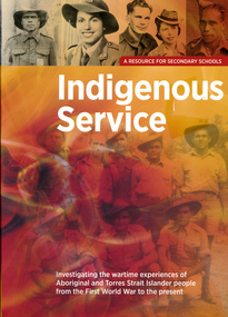
Book, Indigenous Service: a resource book for secondary schools, 1914o
This volume is a resource for secondary schools to investigate the wartime experiences of Aboriginal and Torres Strait Islander people from the First World War to the present.66 pages, colour illustrations, fold out map. Spiral binding with fold around outer cover.world war i, indigenous australians, aborigines, torres strait islanders -
 Glenelg Shire Council Cultural Collection
Map - Map - Map of the Town of Portland in the Colony of Victoria, 1853
Displayed in History House.Map of a harbour and town, bordered with detailed drawings of building of the town and two index keys to sites in the town.Back: (no inscriptions) -
 Greensborough Historical Society
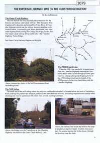
Article, Journal, Keith Patterson, The Paper Mill branch line on the Hurstbridge Railway, by Kevin Patterson, 2012_12
A branch line from the Outer Circle Line was built for the delivery of coal and paper pulp to the Australian Paper Mill at Fairfield. It operated as a branch from the Hurstbridge line until the 1970s, when the Australian Paper Mill plant changed to power by Bass Strait oil. 3 p., text , map and coloured photographs, pp. 4-6 of Nillumbik Custodian December (?) 2012husrstbridge railway line, outer circle railway line, australian paper mill -
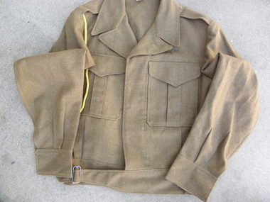 Geelong RSL Sub Branch
Uniform - Battle Dress, Blouse 1956, Trousers no date (mid 20 cenrtury
This Uniform was worn by members of the Australian Army circa 1950 - 1980?This uniform was used by 3/92813 K Walters a National Serviceman circa 1950.Battle Dress Blouse - Khaki. Battle Dress Trousers with Map Pocket - Khaki and Yellow Lanyard (RAASC) Blouse - D D Made in Australia 1956, M. TX Size 7. Trousers -Regimental No 3/92813 Name K Walters M. TX Size 7.uniform, k walters, battle dress, australian army, national service -
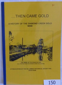 Greensborough Historical Society
Book, Then came gold: a history of the Diamond Creek Gold Mine: by Jock Ryan, 2001_
The Diamond Creek Gold Mine was active from the 1860s and by 1912 had 12 known shafts. This book outlines ownership and contains anecdotes about the mine.A short history of the Diamond Creek Gold MineBook, 9 pages. Black and white illustrations and maps. Yellow front page with clear plastic cover.John Mackey in pencil inside front cover.diamond creek, john l ryan, jock ryan, diamond creek gold mine, gold discoveries victoria -
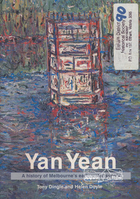 Eltham District Historical Society Inc
Book, Tony Dingle et al, Yan Yean : a history of Melbourne's early water supply / Tony Dingle and Helen Doyle, Monash University, 2003
Book commissioned by Melbourne Water to mark the 150th anniversary of the commencement of the Yan Yean Reservoir.Paperback; vii, 127 p. : ill. (some col.), maps (some col.), ports. ; 23 cm.[written on flyleaf] To Eltham District Historical Society, best wishes Helen Doyleyan yean reservoir -
![Patch, SIMC [Southern Isles Motor Club], c. early 1990s, c. early 1990s](/media/collectors/4f729f7b97f83e0308601892/items/546188982162f10be8b1972c/item-media/5461c65c2162f10be8c6d9de/item-fit-380x285.jpg) Australian Queer Archives
Australian Queer ArchivesPatch, SIMC [Southern Isles Motor Club], c. early 1990s, c. early 1990s
Circular cloth patch featuring a map the shape of Tasmania in green, with text "SIMC" in red, on a blue background.Text: "SIMC" [Southern Isles Motor Club]. -
 Federation University Historical Collection
Booklet - Exercise Book, Sebastopol Mines and Socialism
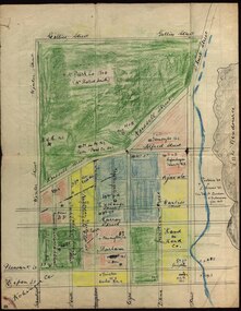
Sebastopol is a suburb of Ballarat..1) Black notebook with red spine .2) hand drawn map showing location of Sebastopol minesHandwritten pageswilliam robertson, new lady don company, kohinor company, leviathon company, newington, copenhagen company, hand in hand company, tannery ground, ballarat freehold company, rough and ready company, park company, inkerman alluvial lead, band & albion consols, gravel pits lead, robert gay, sebastopol mines, ballarat east, alluvial, dalton's flat, canadian gully, red streak, montezuma company, great republic company, golden point, gravel pits, j. hardy, scott's boot shop, lady don company, cgt -
 Federation University Historical Collection
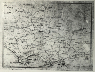
Photograph - Black and White, Map of Western Victoria
WGS 84 37" 47' S 142" 08' EPhotograph of a map showing the Grampians, Glenelg, Portland, Belfast (Port Fairy), Warrnambool, roads and land-holders.western victoria, victoria, belfast, port fairy, warrnambool, manifold -
Federation University Historical Collection
Book, Dr Ian D. Clark et al, Pyrenees Shire, University of Ballarat, Tourism Planning and Development
The Themes that have been most prevalent in the Shire are: Major Mitchell's Impact Pastoral Runs in the Pyrenees Shire Aboriginal History Gold Rush Era Chinese History Wine ProductionPink soft covered book of 35 pages with fifteen appendices. It includes pull out maps and plans. nature based tourism, accommodation, restaurants, transport, attractions, funding, community interest, production development plan, trevor peek, geoffrey gray, djadja wurrung aboriginal clan, the australian tourism commission, tourism victoria, avoca, beaufort, snake valley, amphitheatre, landsborough, lexton, elmhurst, moonambel, mt cole, redbank, mount lonarch, lake goldsmith, st arnaud, lamplough, buangor, natte yallock, navarre/barkly, percydale -
 Federation University Historical Collection
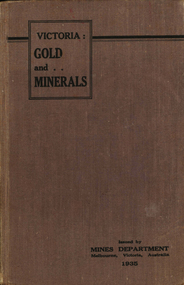
Book, Victoria: Gold and Minerals, 1935, 1935
Hard cover book. Fold out map showing auriferous areas and mineral localities in Victoria, 1935victoria, gold, minerals, 1935, geological map, hydrolic sluicing, panning, pneumatic drill, puddling machine, bendigo, coal mine, wonthaggi, yallourn, jamieson valley, geological school, melbourne university, mount buffalo, electric power station, briquette factory, mines department, george brown, secretary of mines, e.j. hogan, minister of mines, mining -
 Bendigo Historical Society Inc.
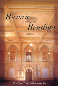
Book - STRAUCH COLLECTION: HISTORIC GUIDE TO BENDIGO
Historic guide to Bendigo, Bendigo Historical Society Inc, 60 pages with maps and black & white photographs.bendigo, history, 19th century bendigo, bendigo-history -
 Bendigo Historical Society Inc.
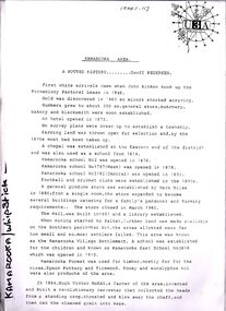
Document - STRAUCH COLLECTION: KAMAROOKA/WHIPSTICK AREA
Envelope containing information & maps on Kamarooka area, includes Kamarooka & Whipstick State Parks, Elmore, Huntly.place, land, kamarooka, kamarooka-whipstick-state parks -
 Bendigo Historical Society Inc.
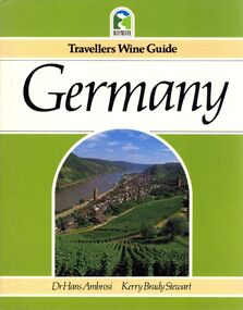
Book - STRAUCH COLLECTION: TRAVELLERS WINE GUIDE GERMANY
Travellers Wine Guide Germany, hard cover with dust jacket, 144 pages with coloured photographs & maps.Dr Hans Ambrosi Kerry Brady Stewartbooks, technical, wine, travel-germany-wine -
 Bendigo Historical Society Inc.
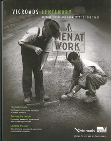
Book - VICROADS CENTENARY
Vicroads Centenary, keeping Victorians connected for 100 years, 141 pages with a loose poster, photographs and maps.victoria, history, transport -
 Bendigo Historical Society Inc.
Book - PASTORAL SETTLEMENT IN NORTHERN VICTORIA - VOL 1. THE COLIBAN DISTRICT, 1979
Pastoral Settlement in Northern Victoria, volume 1, the Coliban District. 353 pages with illustrations, photographs and maps.J.O. Randellhistory, agriculture, northern victoria - coliban, farming, agriculture, pastoral settlement, stations, runs -
 Bendigo Historical Society Inc.
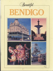
Book - BEAUTIFUL BENDIGO - BOOKLET, 1987
Beautiful Bendigo 24 pages with colour photos and map. 5194 signed by Marion Heeps on front cover.David Barwickbendigo, buildings, bendigo, history of bendigo, architecture, tourism -
 Bendigo Historical Society Inc.
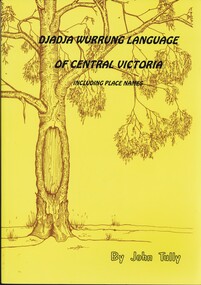
Book - DJADJA WURRUNG LANGUAGE OF CENTRAL VICTORIA INCLUDING PLACE NAMES, 1997
Dadja wurrung language of central victoria 92 pages with photos, illustrations and maps. Published in Maryborough Victoria.John Tullyaboriginal, language, djadja wurrung, djadja wurrung, aboriginal language, bendigo aborigine -
 Bendigo Historical Society Inc.
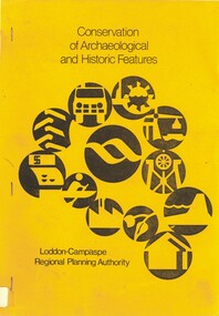
Book - CONSERVATION OF ARCHAEOLOGICAL AND HISTORIC FEATURES, 1977
Conservation of archaeological and historic features Loddon-Campaspe Regional Planning Authority. 51 pages, with photos, and maps.Loddon Campaspe Regional Planning Authoritybendigo, buildings, historic and archaeological, heritage, history, buildings, historic features, heritage features -
 Bendigo Historical Society Inc.
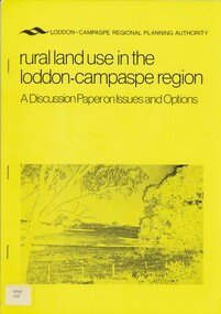
Book - RURAL LAND USE IN THE LODDON-CAMPASPE REGION, 1976
RURAL LAND USE IN THE LODDON-CAMPASPE REGION - a discussion paper on issues and options. 30 pages, with maps.Loddon-Campaspe regional planning authoritybook, rural, land use, loddon campaspe, rural, land use, agriculture -
 Bendigo Historical Society Inc.
Document - BIG HILL TUNNEL DESCRIPTION
Description of the Big Hill Tunnel, why it was built and David Ogilvie who worked on it with a detailed map of the area.bendigo, planning, big hill tunnel -
 Bendigo Historical Society Inc.
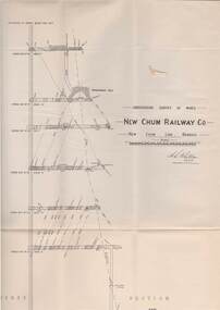
Map - STRUGNELL COLLECTION: UNDERGROUND SURVEY OF MINES, BENDIGO, 29-3-01
Map, Underground Survey of Mines, New Chum Railway Co., New Chum Line, Transverse Section.A.S.Whitelawmap, bendigo, new chum railway co.