Showing 7689 items
matching canning
-
 Kew Historical Society Inc
Plan - Subdivision Plan, Rimington Nursery Estate, 1949
Pru Sanderson, in her groundbreaking ‘City of Kew Urban Conservation Study : Volume 2 - Development History’ (1988), summarised the periods of urban development and subdivisions of land in Kew. The periods that she identified included 1845-1880, 1880-1893, 1893-1921, 1921-1933, 1933-1943, and Post-War Development. These periods were selected as they represented periods of rapid growth or decline in urban development. An obvious starting point for Sanderson’s groupings involved population growth and the associated economic cycles. These cycles also highlighted urban expansion onto land that was predominantly rural, although in other cases it represented the decline and breakup of large estates. A number of the plans in the Kew Historical Society’s collection can also be found in other collections, such as those of the State Library of Victoria and the Boroondara Library Service. A number are however unique to the collection.The Kew Historical Society collection includes almost 100 subdivision plans pertaining to suburbs of the City of Melbourne. Most of these are of Kew, Kew East or Studley Park, although a smaller number are plans of Camberwell, Deepdene, Balwyn and Hawthorn. It is believed that the majority of the plans were gifted to the Society by persons connected with the real estate firm - J. R. Mathers and McMillan, 136 Cotham Road, Kew. The Plans in the collection are rarely in pristine form, being working plans on which the agent would write notes and record lots sold and the prices of these. The subdivision plans are historically significant examples of the growth of urban Melbourne from the beginning of the 20th Century up until the 1980s. A number of the plans are double-sided and often include a photograph on the reverse. A number of the latter are by noted photographers such as J.E. Barnes.The house lots in the Rimington Nursery Estate were advertised for sale on Saturday 22nd October 1949. The nine lots in the sale were in Stoke Avenue and Burke Road. Mathers & McMillan of 136 Cotham Road, Kew, offered the lots for sale. [The final sale of lots within the Rimington Nursery Estate occurred as late as 1958.]subdivision plans - kew, rimington nursery estate, monist victor road - kew (vic.) -
 Kew Historical Society Inc
Plan - Subdivision Plan, Erin Heights Estate, East kew, 1917
Pru Sanderson, in her groundbreaking ‘City of Kew Urban Conservation Study : Volume 2 - Development History’ (1988), summarised the periods of urban development and subdivisions of land in Kew. The periods that she identified included 1845-1880, 1880-1893, 1893-1921, 1921-1933, 1933-1943, and Post-War Development. These periods were selected as they represented periods of rapid growth or decline in urban development. An obvious starting point for Sanderson’s groupings involved population growth and the associated economic cycles. These cycles also highlighted urban expansion onto land that was predominantly rural, although in other cases it represented the decline and breakup of large estates. A number of the plans in the Kew Historical Society’s collection can also be found in other collections, such as those of the State Library of Victoria and the Boroondara Library Service. A number are however unique to the collection.The Kew Historical Society collection includes almost 100 subdivision plans pertaining to suburbs of the City of Melbourne. Most of these are of Kew, Kew East or Studley Park, although a smaller number are plans of Camberwell, Deepdene, Balwyn and Hawthorn. It is believed that the majority of the plans were gifted to the Society by persons connected with the real estate firm - J. R. Mathers and McMillan, 136 Cotham Road, Kew. The Plans in the collection are rarely in pristine form, being working plans on which the agent would write notes and record lots sold and the prices of these. The subdivision plans are historically significant examples of the growth of urban Melbourne from the beginning of the 20th Century up until the 1980s. A number of the plans are double-sided and often include a photograph on the reverse. A number of the latter are by noted photographers such as J.E. Barnes.The Erin Heights Estate in Kew included just seven lots in in Valerie Street. These were all that remained of this wartime subdivision, the other 11 allotments on Balfour and Belford Roads having already been sold. Balfour Road was to be only a temporary name as the street is currently called Windella Avenue. Now, the parkland opposite the subdivision is the reserve created from the route of the Outer Circle Railway. This Railway reached Kew East in 1925, but had been planned as far back as 1873. The development focuses on the benefits of living in Kew: being at the highest of Kew’s ‘suburbs’; being a good residential area; its rapid growth; and the proximity of the Kew East tram in High Street. In 1917, the electric tramline only extended to a terminus at the Harp of Erin hotel. The terminus is clearly represented on the plan.subdivision plans - east kew, erin heights estate -
 Kew Historical Society Inc
Plan - Subdivision Plan, J R Mathers & McMillan, Willsmere Park Estate, c.1940
Pru Sanderson, in her groundbreaking ‘City of Kew Urban Conservation Study : Volume 2 - Development History’ (1988), summarised the periods of urban development and subdivisions of land in Kew. The periods that she identified included 1845-1880, 1880-1893, 1893-1921, 1921-1933, 1933-1943, and Post-War Development. These periods were selected as they represented periods of rapid growth or decline in urban development. An obvious starting point for Sanderson’s groupings involved population growth and the associated economic cycles. These cycles also highlighted urban expansion onto land that was predominantly rural, although in other cases it represented the decline and breakup of large estates. A number of the plans in the Kew Historical Society’s collection can also be found in other collections, such as those of the State Library of Victoria and the Boroondara Library Service. A number are however unique to the collection.The Kew Historical Society collection includes almost 100 subdivision plans pertaining to suburbs of the City of Melbourne. Most of these are of Kew, Kew East or Studley Park, although a smaller number are plans of Camberwell, Deepdene, Balwyn and Hawthorn. It is believed that the majority of the plans were gifted to the Society by persons connected with the real estate firm - J. R. Mathers and McMillan, 136 Cotham Road, Kew. The Plans in the collection are rarely in pristine form, being working plans on which the agent would write notes and record lots sold and the prices of these. The subdivision plans are historically significant examples of the growth of urban Melbourne from the beginning of the 20th Century up until the 1980s. A number of the plans are double-sided and often include a photograph on the reverse. A number of the latter are by noted photographers such as J.E. Barnes. In 1910, the Willsmere Park Estate Dairy was lauded in the Box Hill Reporter as ‘an object lesson in dairying’. Ten years later, in 1923, it was to be sold. The first subdivision of the Estate included 77 grand allotments with frontages to Belford and Kilby Roads, Elm and Willow Groves, and Acacia Avenue. Every lot was claimed to be ‘high and dry’, and with panoramic views of Kew and East Kew. The balance of the Estate, and the largest proportion of allotments was to be subdivided and sold from 1940. This second sale included 109 lots fronting Kilby Road and Elm and Willow Groves. Annotations on the plan indicate that the more expensive lots faced Belford Road opposite the Kew Golf Links. Two of these sold for £310. Lots further to the west in Willow Grove were sold for £60 less. Many of the houses to be built on these 109 allotments after the War faced Government restrictions on building materials and the dimensions of each house due to postwar shortages.subdivision plans - east kew, willsmere park estate -
 Kew Historical Society Inc
Plan - Subdivision Plan, Jas R Mathers Son & McMillan, East Kew Tramway Estate, 1915
Pru Sanderson, in her groundbreaking ‘City of Kew Urban Conservation Study : Volume 2 - Development History’ (1988), summarised the periods of urban development and subdivisions of land in Kew. The periods that she identified included 1845-1880, 1880-1893, 1893-1921, 1921-1933, 1933-1943, and Post-War Development. These periods were selected as they represented periods of rapid growth or decline in urban development. An obvious starting point for Sanderson’s groupings involved population growth and the associated economic cycles. These cycles also highlighted urban expansion onto land that was predominantly rural, although in other cases it represented the decline and breakup of large estates. A number of the plans in the Kew Historical Society’s collection can also be found in other collections, such as those of the State Library of Victoria and the Boroondara Library Service. A number are however unique to the collection.The Kew Historical Society collection includes almost 100 subdivision plans pertaining to suburbs of the City of Melbourne. Most of these are of Kew, Kew East or Studley Park, although a smaller number are plans of Camberwell, Deepdene, Balwyn and Hawthorn. It is believed that the majority of the plans were gifted to the Society by persons connected with the real estate firm - J. R. Mathers and McMillan, 136 Cotham Road, Kew. The Plans in the collection are rarely in pristine form, being working plans on which the agent would write notes and record lots sold and the prices of these. The subdivision plans are historically significant examples of the growth of urban Melbourne from the beginning of the 20th Century up until the 1980s. A number of the plans are double-sided and often include a photograph on the reverse. A number of the latter are by noted photographers such as J.E. Barnes.The East Kew Tramway Estate was a subdivision of two separate parcels of land between Adeney Avenue and Normanby Road. The larger section included 54 lots facing Adeney Avenue, Argyle Road, and Campbell, Hunter and Wishart Streets. [Hunter and Wishart Streets were created as part of the subdivision.] A further 17 allotments faced Normanby Road, Hubert and Campbell Streets. [The name of Hubert Street was later to be changed to Cecil Street.] The promotion of the sale referred to the advantages of living between two tram routes, in High Street and Cotham Road. On the plan, quaintly drawn trams mark these routes. Also on the plan is the route of part of the Outer Circle [Railway] Line.east kew tramway estate, subdivision plans - east kew -
 Kew Historical Society Inc
Plan - Subdivision Plan, J R Mathers & McMillan, Clutha Subdivision, 1940
Pru Sanderson, in her groundbreaking ‘City of Kew Urban Conservation Study : Volume 2 - Development History’ (1988), summarised the periods of urban development and subdivisions of land in Kew. The periods that she identified included 1845-1880, 1880-1893, 1893-1921, 1921-1933, 1933-1943, and Post-War Development. These periods were selected as they represented periods of rapid growth or decline in urban development. An obvious starting point for Sanderson’s groupings involved population growth and the associated economic cycles. These cycles also highlighted urban expansion onto land that was predominantly rural, although in other cases it represented the decline and breakup of large estates. A number of the plans in the Kew Historical Society’s collection can also be found in other collections, such as those of the State Library of Victoria and the Boroondara Library Service. A number are however unique to the collection.The Kew Historical Society collection includes almost 100 subdivision plans pertaining to suburbs of the City of Melbourne. Most of these are of Kew, Kew East or Studley Park, although a smaller number are plans of Camberwell, Deepdene, Balwyn and Hawthorn. It is believed that the majority of the plans were gifted to the Society by persons connected with the real estate firm - J. R. Mathers and McMillan, 136 Cotham Road, Kew. The Plans in the collection are rarely in pristine form, being working plans on which the agent would write notes and record lots sold and the prices of these. The subdivision plans are historically significant examples of the growth of urban Melbourne from the beginning of the 20th Century up until the 1980s. A number of the plans are double-sided and often include a photograph on the reverse. A number of the latter are by noted photographers such as J.E. Barnes.The subdivision plan for the Clutha Subdivision is one of the largest in the Society’s collection. The plan includes a map of the proposed allotments, photographic views to the north and south, and information about the kinds of buildings that could be constructed on the allotments. The subdivision was bounded by Studley Park Road, and Carson, Stevenson and Edgecombe Streets. Two new streets, Mackie Court and Younger Street were created as part of the subdivision. The subdivision took its name from ‘Clutha’, the home of John Carson, who was to become Mayor of Kew in 1863. A Report to the City of Boroondara outlined how: ‘The Clutha estate was progressively developed from 1940, with new houses under construction on the Studley Park Road, Carson and Edgecombe Street frontages by 1941. By 1943, directory listings were available for all addresses with the exception of Mackie Court. Building ceased after the government’s prohibition on civilian building was enforced from 1942, with little change in listings until the 1950s when the remainder of the subdivision was developed’."H"subdivisions - kew - studley park, clutha subdivision, studley park road -
 Kew Historical Society Inc
Plan - Subdivision Plan, Jas R Mathers Son & McMillan, Macartney Estate, East Kew, c. 1925
Pru Sanderson, in her groundbreaking ‘City of Kew Urban Conservation Study : Volume 2 - Development History’ (1988), summarised the periods of urban development and subdivisions of land in Kew. The periods that she identified included 1845-1880, 1880-1893, 1893-1921, 1921-1933, 1933-1943, and Post-War Development. These periods were selected as they represented periods of rapid growth or decline in urban development. An obvious starting point for Sanderson’s groupings involved population growth and the associated economic cycles. These cycles also highlighted urban expansion onto land that was predominantly rural, although in other cases it represented the decline and breakup of large estates. A number of the plans in the Kew Historical Society’s collection can also be found in other collections, such as those of the State Library of Victoria and the Boroondara Library Service. A number are however unique to the collection.Subdivision plans are historically important documents used as evidence of the growth of suburbs in Australia. They frequently provide information about when the land was sold on which a built structure was subsequently constructed as well as evidence relating to surveyors and real estate and financial agents. The numerous subdivision plans in the Kew Historical Society's collection represent working documents, ranging from the initial sketches made in planning a subdivision to printed plans on which auctioneers or agents listed the prices for which individual lots were sold. In a number of cases, the reverse of a subdivision plan in the collection includes a photograph of a house that was also for sale by the agent. These photographs provide significant heritage information relating house design and decoration, fencing and household gardens.The Macartney Estate subdivision advertised 21 lots for sale on either side of Macartney Street (now Macartney Avenue) and Evans Road in what was then designated as East Kew. Most of the houses shown on the south side of Macartney Street then, as now, have rear entrances on Mount Street, however a number of these blocks have since been further subdivided to allow for the building of new houses on the rear of a block. Brougham Place is marked on the plan but is now called Daniell Place."C"subdivision plans - east kew, macartney estate, macartney street, mount street, evans road, brougham place -
 Kew Historical Society Inc
Plan - Subdivision Plan, J R Mathers & McMillan, Glenarbor Estate, 1934
Pru Sanderson, in her groundbreaking ‘City of Kew Urban Conservation Study : Volume 2 - Development History’ (1988), summarised the periods of urban development and subdivisions of land in Kew. The periods that she identified included 1845-1880, 1880-1893, 1893-1921, 1921-1933, 1933-1943, and Post-War Development. These periods were selected as they represented periods of rapid growth or decline in urban development. An obvious starting point for Sanderson’s groupings involved population growth and the associated economic cycles. These cycles also highlighted urban expansion onto land that was predominantly rural, although in other cases it represented the decline and breakup of large estates. A number of the plans in the Kew Historical Society’s collection can also be found in other collections, such as those of the State Library of Victoria and the Boroondara Library Service. A number are however unique to the collection.The Kew Historical Society collection includes almost 100 subdivision plans pertaining to suburbs of the City of Melbourne. Most of these are of Kew, Kew East or Studley Park, although a smaller number are plans of Camberwell, Deepdene, Balwyn and Hawthorn. It is believed that the majority of the plans were gifted to the Society by persons connected with the real estate firm - J. R. Mathers and McMillan, 136 Cotham Road, Kew. The Plans in the collection are rarely in pristine form, being working plans on which the agent would write notes and record lots sold and the prices of these. The subdivision plans are historically significant examples of the growth of urban Melbourne from the beginning of the 20th Century up until the 1980s. A number of the plans are double-sided and often include a photograph on the reverse. A number of the latter are by noted photographers such as J.E. Barnes.The little-known Glenarbor Estate comprised 23 allotments bordering Wellington and Denmark Streets and Fenton Avenue. The auction of the allotments in the Estate was held in the Kew Recreation Hall. The purported advantages to Kew are identified on the plan, such as the close proximity of the entrance to the Kew Railway Station and access to shops in Denmark Street. Due to its location, the subdivision was pitched at commercial as well as residential purchasers. The Estate was to cause a crisis in the Kew Council as a majority of councillors voted on 29 May to acquire the entire Estate as the location of a new Town Hall. The Estate was said to be valued at £50,000. A later meeting was to rescind the vote, instead opting for the compulsory acquisition of South Esk on the corner of Charles Street and Cotham Road. That acquisition was to be overturned by the State Government. The debate about the purchase of the Glenarbor Estate by Council coincided with the decision to widen High Street on the South side between Cotham Road and the Junction."D"subdivision plans - kew, glenarbor estate, wellington street, denmark street -
 Kew Historical Society Inc
Plan - Subdivision Plan, Jas R Mathers Son & McMillan, The Dale Estate, Deepdene, 1918
Pru Sanderson, in her groundbreaking ‘City of Kew Urban Conservation Study : Volume 2 - Development History’ (1988), summarised the periods of urban development and subdivisions of land in Kew. The periods that she identified included 1845-1880, 1880-1893, 1893-1921, 1921-1933, 1933-1943, and Post-War Development. These periods were selected as they represented periods of rapid growth or decline in urban development. An obvious starting point for Sanderson’s groupings involved population growth and the associated economic cycles. These cycles also highlighted urban expansion onto land that was predominantly rural, although in other cases it represented the decline and breakup of large estates. A number of the plans in the Kew Historical Society’s collection can also be found in other collections, such as those of the State Library of Victoria and the Boroondara Library Service. A number are however unique to the collection.The Kew Historical Society collection includes almost 100 subdivision plans pertaining to suburbs of the City of Melbourne. Most of these are of Kew, Kew East or Studley Park, although a smaller number are plans of Camberwell, Deepdene, Balwyn and Hawthorn. It is believed that the majority of the plans were gifted to the Society by persons connected with the real estate firm - J. R. Mathers and McMillan, 136 Cotham Road, Kew. The Plans in the collection are rarely in pristine form, being working plans on which the agent would write notes and record lots sold and the prices of these. The subdivision plans are historically significant examples of the growth of urban Melbourne from the beginning of the 20th Century up until the 1980s. A number of the plans are double-sided and often include a photograph on the reverse. A number of the latter are by noted photographers such as J.E. Barnes.The Dale Estate in Deepdene was made possible by the death of Robert Sparrow Smythe, Australian journalist, newspaper editor/owner and theatrical manager. Smythe lived in his residence ‘Highate’, Deepdene until his death in 1917. In the subdivision proposed one year later, before the end of the First World War, 18 allotments were to be created. The very fragmentary plan in the Society’s collection notes that a large weatherboard [house] will need to be removed. This may be Smythe’s own home. The proposed subdivision included allotments facing Burke and Whitehorse Roads and Dale Street. Bordering the subdivision is the Deepdene Station and the Outer Circle Railway Line. The clear directions on the plan indicate that in 1918 it was possible to travel by train from Deepdene to East Camberwell and Ashburtonsubdivision plans - deepdene, the dale estate -
 Kew Historical Society Inc
Plan - Subdivision Plan, Jas R Mathers Son & McMillan, Clifton Estate, Kew, c. 1916
Pru Sanderson, in her groundbreaking ‘City of Kew Urban Conservation Study : Volume 2 - Development History’ (1988), summarised the periods of urban development and subdivisions of land in Kew. The periods that she identified included 1845-1880, 1880-1893, 1893-1921, 1921-1933, 1933-1943, and Post-War Development. These periods were selected as they represented periods of rapid growth or decline in urban development. An obvious starting point for Sanderson’s groupings involved population growth and the associated economic cycles. These cycles also highlighted urban expansion onto land that was predominantly rural, although in other cases it represented the decline and breakup of large estates. A number of the plans in the Kew Historical Society’s collection can also be found in other collections, such as those of the State Library of Victoria and the Boroondara Library Service. A number are however unique to the collection.The Kew Historical Society collection includes almost 100 subdivision plans pertaining to suburbs of the City of Melbourne. Most of these are of Kew, Kew East or Studley Park, although a smaller number are plans of Camberwell, Deepdene, Balwyn and Hawthorn. It is believed that the majority of the plans were gifted to the Society by persons connected with the real estate firm - J. R. Mathers and McMillan, 136 Cotham Road, Kew. The Plans in the collection are rarely in pristine form, being working plans on which the agent would write notes and record lots sold and the prices of these. The subdivision plans are historically significant examples of the growth of urban Melbourne from the beginning of the 20th Century up until the 1980s. A number of the plans are double-sided and often include a photograph on the reverse. A number of the latter are by noted photographers such as J.E. Barnes.The Clifton Estate was an ambitious subdivision. It included 61 allotments bordering Cotham and Park Hill Roads, and Florence and Adeney Avenues. It is difficult to ascertain the exact year when the ‘Clifton Estate’ was surveyed, subdivided and first auctioned. The uncertainty may be due to allotments being released during the First World War. The subdivision took its name from the house ‘Clifton’ (lot 5) on the corner of Adeney Avenue and Cotham Road. The outline of Clifton (since demolished) and the extent of its land following the subdivision are represented on the plan. The auctioneers have also shown ‘Maryfield’ and ‘Wimba’, the neighbouring properties in Cotham Road, on the plan."B"subdivision plans - kew, clifton estate, cotham road, adeney avenue, florence avenue, park hill road -
 Kew Historical Society Inc
Plan - Subdivision Plan, Plan of Subdivision of Part of Crown Portion 84 / Parish of Boroondara / County of Bourke / Lodged Plan No. 2217, Twentieth Century
Pru Sanderson, in her groundbreaking ‘City of Kew Urban Conservation Study : Volume 2 - Development History’ (1988), summarised the periods of urban development and subdivisions of land in Kew. The periods that she identified included 1845-1880, 1880-1893, 1893-1921, 1921-1933, 1933-1943, and Post-War Development. These periods were selected as they represented periods of rapid growth or decline in urban development. An obvious starting point for Sanderson’s groupings involved population growth and the associated economic cycles. These cycles also highlighted urban expansion onto land that was predominantly rural, although in other cases it represented the decline and breakup of large estates. A number of the plans in the Kew Historical Society’s collection can also be found in other collections, such as those of the State Library of Victoria and the Boroondara Library Service. A number are however unique to the collection.The Kew Historical Society collection includes almost 100 subdivision plans pertaining to suburbs of the City of Melbourne. Most of these are of Kew, Kew East or Studley Park, although a smaller number are plans of Camberwell, Deepdene, Balwyn and Hawthorn. It is believed that the majority of the plans were gifted to the Society by persons connected with the real estate firm - J. R. Mathers and McMillan, 136 Cotham Road, Kew. The Plans in the collection are rarely in pristine form, being working plans on which the agent would write notes and record lots sold and the prices of these. The subdivision plans are historically significant examples of the growth of urban Melbourne from the beginning of the 20th Century up until the 1980s. A number of the plans are double-sided and often include a photograph on the reverse. A number of the latter are by noted photographers such as J.E. Barnes.Undated Plan of Subdivision of Crown Portion 84 in what is now Kew. The area shown is bordered by Burke Road, Harp Road, Arglye Road and Normanby Road.subdivision plans -- kew (vic), harp road, burke road, normanby road, lady loch's drive, gladstone street, second avenue, first avenue -
 Surrey Hills Historical Society Collection
Photograph, 1st Surrey Hills Boy Scout Troop c. 1909-1912
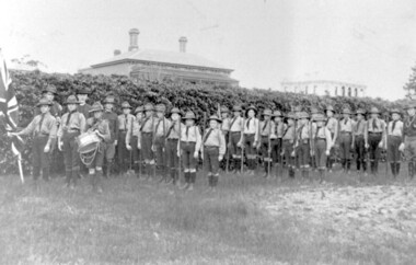
1st Surrey Hills Boy Scout Troop was formed in 1909 by Theodore Hendy, two years after Lord Robert Baden-Powell had started the Movement. Hendy (left back) sent Baden-Powell greetings advising he was sending a photo of his troop. This could be the photograph. Taken in the grounds of his home "Kookaburra" (demolished) in Albany Crescent, Surrey Hills (later given the number 44). The Royal Hotel on the corner of Canterbury Road and Broughton Road can be seen on the right. The photograph was taken by M. Hill, uncle of Mr W. Dempsey. 'Kookaburra' was the home of Theodore Hendy's uncle Archibald Noete Hendy, an estate agent. Earlier it was known as 'Glastonbury'. In c1938 the house was demolished and the land divided into 4 lots. Archibald Hendy and his wife Bertha Bowen (nee Rohs) later resided at 'Barehin' in Pembroke Street. Black & white photo of 1st Surrey Hills Boy Scout Troop in the grounds of 'Kookaburra' (now demolished) in Albany Crescent Surrey Hills. In the background are 2 buildings. surrey hills scout troop, 1900-1909, 1910-1919, royal hotel, albany crescent, surrey hills, uniforms, hats, flags, clothing and dress, canterbury road, broughton road, house names, hotels, scout groups, youth clubs, (mr) w dempsey, (mr) m hill, (mr) theodore hendy, 'kookaburra' -
 Surrey Hills Historical Society Collection
Work on paper - Ephemera: Theatre program - Miss Hook of Holland, 24 & 26 June 1933, H Bowley, Printer, 192 Canterbury Road, Canterbury, June 1933
"Miss Hook of Holland" is a musical comedy (described as a "Dutch Musical Incident") in two acts, with music and lyrics by Paul Rubens and book by Austen Hurgon and Rubens. It opened at the Prince of Wales Theatre, London, on 31 January 1907, and had a successful run of 462 performances. A synopsis of the plot can be found at https://www.guidetomusicaltheatre.com/shows_m/miss_hook_holland.htm This was one of a number of productions of the Surrey Hills Amateur Operatic Society during the 1930s. The society formed in 1931 and its first production was "The Cingalee", followed in 1932 by "The Arcadians". Other productions were "Princess Ju-Ju", "The Quaker Girl", "The Hook of Holland" and "The Country Girl". Apart its cultural and social importance, the aim of the Society was to raise funds for charity. Mrs Constance Clucas was a driving force behind the productions. A comprehensive account of the society's activities is found in 'A history of Surrey Hills' Sporting clubs and Cultural Groups" by Ken James. This and other programs of the Surrey Hills Amateur Operatic Society provide insight into the cultural life of Surrey Hills in the 1930s.Cream-coloured stapled program printed in brown of a musical comedy in 2 acts. Includes a cast list and committee of the Surrey Hills Amateur Operatic Society, a synopsis of the play, a list of the musical items, photos of Mrs P D Clucas and Mr Norman Lee and a number of ads for local and city businesses."J Hall" signed on back in ink or biro; Norman Lee has signed his photo in ink.camberwell town hall, operetta, miss hook of holland, tanner and monckton, surrey hills amateur operatic society, j c williamson ltd, surrey hills baby health centre, alfred hospital, orthopaedic hospital, surrey hills orchestra, anne's pantry, surrey hall, entertainment, fundraising, musical events and activities, miss cook, mr j colquhoun, h e witchell, a h chenu, norman lee, jean gordon, wilfred darby, jeanette mcdowell, ronald isherwood, howard p denny, miss phyllis heitsch, una v blaikie, howard burnett, jack chapman, winifred broderick, gladys marshall, scyla cocking, harold g brett, harry cocking, aubrey pearce, william morrison, muriel middleton, barbara brigdon, jessie collins, ethel cerini, isabel callaghan, florrie doreian, violet ebbels, jessie fethers, margot gordon, jean robinson, gordon lavender, marjory gordon, grace linford, mollie middleton, eileen middleton, muriel marshall, gladys oliver, mary scragg, beryl scragg, nina sinclair, jean wearne, gladys roberts, rose pearse, jean douglass, jessie powys, mabel thomas, violet abery, roy brian, herbert darby, wilfred harley, robert rowse, jack walker, fred williams, george duncan, mrs g d clucas, mrs p d blaikie, miss w h duncan, mrs g d grover, mrs b collins, miss m harley, mr r cocking, mr h colton, ada walton, mrs c colquoun -
 Vision Australia
Leisure object - Object, Swish bat, 199
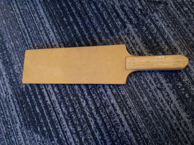
The wooden bat is used to play the game 'Swish' which is a fast, invigorating game, and was developed by blind people in Australia and has been played here for many years. It is played on both a recreational and competitive level; and allows blind, vision impaired and sighted people to compete on almost equal terms. Swish is like table tennis, but instead of hitting a ball over a net, the ball is hit under a net and must travel along the surface of the table. The net is at a height that so that those players with various degrees of sight do not have an advantage over blind players. The ball has bells in it to make it audible and it is about the size of a tennis ball and made of plastic with holes in it. Swish is either played as a doubles or singles competition. The game can be played from one game to the best of five, and the first to eleven or the advantage of 2 after eleven.1 light brown, wooden rectangular paddle or batting surface with a short handle recreation, swish -
 Vision Australia
Administrative record - Text, 93rd Annual Report Royal Blind Society of N.S.W. (1973), 1973
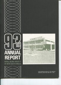
Articles in the annual report include: the expenses incurred due to increased client numbers and wages rises, the need and inability to sell the Woollahra (Helen Keller hostel) site, the success of the fledging Reference Library seen as a model for other organisations, Matron Scott (Victor Maxwell nursery) received an M.B.E., plans to develop 3 more day centres to add to the five already operating, operations undertaken in the workshop, continued demand for places at Alexis Albert and Lighthouse hostels, recognition through the renaming of 2UW Blind Appeal to the 2UW Lions Blind Appeal which has been run since 1952, blind bowlers looking forward to being on the green at Enfield, Cricket club looking forward to when tip in Mitchell St is filled in so that it can be made into a home ground, and the collaborative relationship had with other blindness related organisations.1 volume of text and imagesroyal blind society of new south wales, corporation records -
 Melbourne Legacy
Letter, Gertie Gilles to Legatee Aaron Beattie, 1959
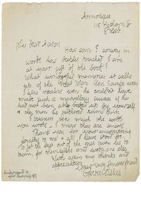
A letter from Gerta Gillies to Legatee Aaron Bettie about the publication of the biography of Stan Savige. Mrs Gillies was the first instructor for girls classes. Legatee Aaron Beattie helped organise many of the early demonstrations. The letter says Mrs Gillies was thrilled to receive a copy of the book by W B Russell titled 'There goes a man'. She says: 'How can I convey in words how deeply touched I am at your gift of the book! What wonderful memories it calls up of the Great Man, General Savige. I also realise even he couldn't have made such as marvellous success if he had not been ably backed up by yourself and the men he gathered round him'. Attached to the letter was a newspaper article dated 10/10/1959 discussing the publication of the book.A record of a past staff member praising Savige and the legatees.Blue paper letter to Legatee Beattie about Stan Savige's biography.gillies, aaron beattie -
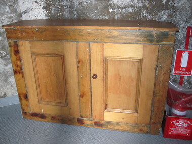 Parks Victoria - Gabo Island Lightstation
Cabinet
Cupboard is original to Lighthouse. This nineteenth century cedar furnishing has two doors and one internal shelf. It remains in the lighthouse although its original location was probably the lantern room, where similar surviving cabinets are more typically found. It was purpose built for the lighthouse with a curved back to fit the proportions of the tower interior with the wood reputed to have originated from a partition in the assistant lightkeepers’ houses, and the cupboard doors possibly crafted at a different time. Curved cabinets similar to this example can be found at three other early lighthouses investigated by this study. It is possible that these specially designed cabinets were included in the standard complement of furnishings provided to the colony’s lightstations by the Victorian Public Works Department. Other similar cabinets with curved backs remain in the Point Hicks Lighthouse and at Cape Nelson (two examples )and Cape Schanck, which has a curved front as well as back .The Gabo Island cabinet has first level contributory significance for its historic value, uniqueness, provenance to the lightstation and clear association with the functions of the lighthouse lantern room.Two door wooden (cedar) cabinet. One internal shelf, panelled, curved back. Doors are attached. Frame has been stripped, doors are unpainted. -
 Wodonga & District Historical Society Inc
Album - Ringer's River by Des Martin - Plate 33 - Escaping the Police
The bodies of mother and son are driven side by side to burial while the shops shut down and all Overton turns out for the funeral. Ellen's elder son Con O'Hara, and Sean O'Day ride as outriders to the hearses. Sgt. Baker and his men arrive at the church, the Sgt. approaches Con, declares that no police action will be taken before the town re-opens, and asks if he can provide an escort for the cortege. The funeral over O'Day tarries till after the shops have opened and Sgt. Baker sets a trap for him on the bridge over the Murray. Cornering him on the bridge he says it will give him great pleasure to personally escort him all the way to the police station. "All the way Sergeant?" asks O'Day. "Then come on!" With which he jumps his horse over the rail of the bridge. D.J. Martin on Pampas Air.The album and images are significant because they document literature written by a prominent member of the Wodonga community. The presentation of this precis was supported by several significant district families and individuals.Ringer's River Album Coloured photo Plate 33des martin, many a mile, ringer's river, northeast victoria stories -
 Melbourne Legacy
Document - Minutes, Minutes of Meeting of Board of Management (H49)
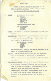
Records an extended Board Meeting which took place from 7.30-11.30 p.m on Thursday 16 July 1928 at the office of the Hon Sec in Collins Street , adjourning until 1.00-8.15 pm on Monday 20 August 1928 at the Alcazar Cafe, and then from 1.00-2.15 pm on Wednesday 22 August 1928, also at the Alcazar Cafe. No mention is made of any meals, but it can be assumed that such a long meeting included both food and drink. 56 items were discussed including membership, Junior Legatee activities and supervision, non-attendance by rostered Legatees and conference matters. Mention was made of the stewardship of the Club origin and history; unfortunately despite this promising start much has been lost over the years since. After this epic meeting, the next one was scheduled for 13 September, 1928.Not only do the minutes record the work done by Legacy in the early days, but illustrates the different style of governance in more leisurely times.White foolscap copy sheets x 8 pages of a board of management meeting"H49" (see Item 00937) in blue ballpoint.board of management, founding legatee -
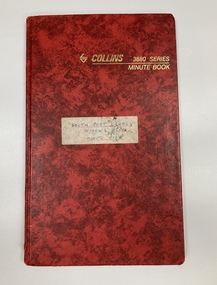 Melbourne Legacy
Book - Minutes, Southport Widows' Club Minute Book
The minutes of the Southport Widows' Club from 1988 to 1994. South Port was a widows' club was made up of widows from South Melbourne and Port Melbourne. At one stage it had been called Parks Legacy Club. The pages show that each meeting started with a minute silence in memory of their husbands. Also inside the front cover is The Legacy Widows' prayer that the widows would use. 'Let us be kind to one another and see in each other the best that we can find. There is so much sadness in the world and so many lives are dependant on us for brightness. Lord keep us brave. Help us to be kind. Amen. Gwen Gunn was the secretary or treasurer during some of this time and had minute book in her care. It was sent to Melbourne Legacy by Gwen's granddaughter Danni Moore in 2020.A record of the business practices for formal meetings in the 1980s and that Widows' Clubs provided a valuable purpose of meeting for the widows. Minute book with red bound cover around lined pages.Label on cover says 'South Port Widows' Club Minute Book'.widows, widows club, meetings, prayer -
 Forests Commission Retired Personnel Association (FCRPA)
Ventimeter, Wind anemometer in cardboard tube
Bushfire behaviour is influenced by many factors including temperature, relative humidity (RH), forest type, fuel quantity and fuel dryness, topography and even slope. But wind has a dominant effect on the Rate of Spread (ROS), as well as fire size, shape and direction. Wind speed can be measured using a variety of anemometers. This simple hand-held Venitimer was made by Elvometer in Sweeden, probably in the 1960s, and was designed for principally for mariners. Some models have a compass in the handle to measure wind direction. The small inlet hole on the side is faced towards the wind and air pressure lifts small plastic disk inside. The upper tube is tapered so that as wind speed increases more air escapes and stronger winds are needed to raise the disk. Wind speed in MPH is read from the side of the clear plastic tube. The waterproof container has instructions on use and conversion scales. Simple and robust device.Hand- held wind anemometer Instructions on use on containerbushfire, forests commission victoria (fcv) -
 Merri-bek City Council
C-type print, Rennie Ellis, The Streaker, Grand Final, MCG 1982, 1982
Rennie Ellis (1940–2003) was as a pivotal figure in Australian visual culture. He was both a documentary photographer and a prominent presence in advertising, television and photography. Ellis was known for his candid documentary images of contemporary Australian life. His photographs of social events, such as music festivals, fashion parades or nightclubs are iconic, but his practice also encompassed the grittier side of life. In his AFL series, Ellis skilfully portrays the nation’s passion for the game, extending his lens beyond the boundary line to showcase the spirited fans alongside the on-field action. In Ellis' photo, a woman streaks at an AFL game – two players stand in frame with her, a Richmond and Collingwood player respectively. Behind them the crowd and a large Richmond banner can be seen. Playful and spirited interactions such as this are a key aspect of Australian football culture. -
 Melbourne Tram Museum
Photograph - Black and White - demolishing cable tram crossing 1954/55
The photograph shows the demolition or removal of the cable tram track at an un-identified location, showing the removal of the yokes and track where two cable lines crossed over each other. Shows the former cable tram yokes that supported the slot rails and some details of the cable tunnels and pits. The man in the bottom left could be cutting the yokes with an oxy-acetylene cutting torch. In the view are at the top of the photo some rails can be seen. There were a number of points where the cable tram crossed other electric or cable tram lines. Given the small work site and men involved the location could potentially be either Johnston Street and Smith Street or Johnston St and Nicholson Street. The 1955 Annual Report notes that work commenced following the completion of the Queen's visit in March 1954 and that all work was done by day-labour. Photographer is possibly Keith Kings.Yields information about the extent of work need to convert the former Bourke St group of Cable tram lines to Electric trams, the people, the extent of the original construction and the methods used to undertake the work.Photograph - Black and White - demolishing cable tram trackwork where two cables crossed over each other, 1954/55.trams, tramways, cable trams, workmen, mmtb, demolition, track work, conversion, smith street, fitzroy, johnston street, nicholson street -
 Vision Australia
Equipment - Object, American Foundation for the Blind, Tellatouch
The Tellatouch was developed in the American Foundation research laboratory and resulted from one of the first AFB research projects, a major effort in the mid-1940s to help deaf-blind people. The device helped end social isolation for hundreds of deaf-blind children and adults. The Tellatouch provides a means of communication between a sighted (or blind) person and a deaf-blind person who can read braille. The keyboard has three rows of ten keys each and a standard braille keyboard on the fourth row. At the rear of the machine is a round metal plate with the braille cell in the center. The deaf-blind person rests a finger on the braille cell. Pins rise to form the equivalent of the letter key that is struck. The body of the device covered in beige vinyl, with a hinged lid at the front which lifts up to reveal the keyboard. The lid is secured with a metal latch at the front.Beige vinyl machine with leather carry strapbraille equipment, assistive devices -
 Vision Australia
Equipment - Object, Hand frame with grid
Braille hand frames and styluses were the primary way to produce Braille for over a century. The stylus was used to make a separate indentation for each dot, and the hand frame to keep dots within the same cell. Braille rows are produced from right to left. The process was very time consuming. Volunteer transcribers for the library could take an average of ½ hour to produce one page of Braille using this method. For example: “Oliver Twist” required approximately 600 sheets equating to 300 hours of work! This wooden slate, which was used to make the system portable, served as a firm base needed to sustain puncture pressure. The frame can also be slotted into both sides of the slate, thereby ensuring that the lines of Braille were straight across the page. The metal clasp at the top of the frame held the wooden which kept paper from slipping.Brown plastic rectangular hand frame with holes evenly spaced on either long side. Hinged Braille metal guide with space for 2 rows of Braille, each 35 cells long. braille equipment, rnib -
Vision Australia
Document - Text, RVIB Hamilton Auxiliary, 1929-2000
The Hamilton RVIB Auxiliary formed on December 5th, 1929. This collection of papers includes the minute books from 1929 until 2000, including newspaper clippings from local and state papers, correpondence, financial reports, invitations and RVIB pamphlets and circulars. In October 1969, RVIB asked Auxiliaries to promote the television appearance of Robert Leeman, a blind harmonica player. In response to the Hamilton Auxiliary's congratulatory note, both Robert and his mother replied to the Auxiliary and as well as these letters, an article from the TV Times was also kept. Congratulations cards for Mabel White's 40 and 50 years of service can also be found in the minute books. The index cards were maintained by RVIB and contain the amount of donations made by the Auxiliary between 1976-1995, as well as the presentations delivered by RVIB employees to Auxiliary meetings between 1973-1985.6 minute books -- 2 index cardsroyal victorian institute for the blind, auxiliaries -
 Melbourne Tram Museum
Postcard, Rose Stereograph Co, "Melbourne from the Air", early 1940s
Rose Series postcard No. P 622, titled ""Melbourne from the Air", Photo looking east over Melbourne with the Melbourne skyline, railway yards, St Kilda Road, Yarra River and Princes Bridge in the view. Three trams can be seen in the view in St Kilda Road. The building in the middle bottom of the photo is the recently completed Australian Provincial Assurance (APA) Assocation Limited Head Office on the south east corner of Collins and Queen Streets. This 1889 building was refaced and the tower added in 1928-1929. The adding of three additional floors to the Bank of Australasia building, 1875-1876, is well in hand 1929-1931 on the north west corner of Queen and Collins Streets. On the south east corner of the corner of Collins and Market Streets, the new Australian Mutual Provident (AMP) Society Head Office is reaching full height, also constructed 1929-1931. Yields information about an aerial view of Melbourne C1930Postcard - printed real photograph with Rose Stereograph Co. name on the rear.tramways, trams, aerial views, melbourne, collins st. -
 Linton and District Historical Society Inc
Photograph, Shire of Grenville Hall and Angus Shop, Sussex Street, Linton
Shire of Grenville Hall and Angus shop, Sussex Street, Linton. Dating the photograph: The photograph can be dated to after 1887, when John Angus purchased the shop building (originally owned by Thomas Austin) from B. N. Dodd. 'W. Angus': From 1887 until the late 1890s the shop was run by John Angus' wife Wilhelmina Angus, who often advertised her business in the local newspaper, the 'Grenville Standard' (see photograph of advertisement, Registration no. 2019-346). It is not known when Mrs Angus retired, but it is understood that her son William then took over the shop. Elsie Jennings, an Angus descendant, recalled in a letter to LDHS that her uncle had run a draper's shop at this site. (See letter in "Linton - Township History - Recollections and reminiscences' file.) It is not clear whether the "W. Angus" in the sign refers to Wilhelmina Angus or to William Angus.Enlarged black and white copy of original photograph, which has been mounted on white card. The photograph shows a two-storey brick building, and next to it a double-fronted shop. The two-storey building is the original Grenville Shire Hall, built in the mid 1860s. The fence outside it is being used to post notices. Two large pine trees are between the fence and the building. The smaller shop next to the hall has a verandah supported by round timber posts, and signs across the front of the verandah read "Tailor" and "W. Angus". Two men engaged in conversation with each other are standing to the left under the verandah. There is a flagpole attached to one of the gate posts of the hall, and there is a telegraph pole in the street in front of the hall.w. angus, william angus, wilhelmina angus (née statemann), buildings, shire of grenville hall, shops, shire hall, town hall -
City of Moorabbin Historical Society (Operating the Box Cottage Museum)
Newsletter - City of Moorabbin Historical Society No. 6 January / February 1962, City of Moorabbin Historical Society Newsletter No. 6 January / February 1962, 1962
This is Newsletter No.6 produced by CMHS President Mr T.A. Sheehy in January / February 1962 The Aims of the CMHS are ‘to record the history of the City, and register something of the Australian Atmosphere, which the necessary speed-up in post-world-war two (WW11) immigration has caused to be lost; to produce a magazine at regular intervals, featuring the work of pioneers and the changing Australian scene; to work constantly with a long range view towards building a hall where records and exhibits can be housed’ The Original Newsletters reflect the history and heritage of the former City of Moorabbin — derived from Mooroobin, ‘a resting place’ in the Bunurrung spoken language. In 1994, the City of Moorabbin was integrated into the Cities of Bayside, Glen Eira, Kingston and Monash. This Issue - Centenary Year Moorabbin; from Pastoral, Fishing, market gardening to suburban industrial; 'The Tuck Family'; Moorabbin City Band;This is No 6 Newsletter of CMHS January / February 196 CMHS obtained a Kingston City Council Community Grant 2016 for the digitization and preservation of these Original CMHS Newsletters commenced in 1961 2 x pages Foolscap paper printed on 1 side.CITY OF MOORABBIN HISTORICAL / SOCIETY / President T.A Sheehy ...... Ssecretary Mrs L. Harvey ...../ NEWSLETTER No 6 January / February 1962 -
City of Moorabbin Historical Society (Operating the Box Cottage Museum)
Newsletter - City of Moorabbin Historical Society No. 7 March 1962, City of Moorabbin Historical Society Newsletter No. 7 March 1962, 1962
This is Newsletter No 7 produced in March 1962 by Mr T. A. Sheehy President CMHS The Aims of the CMHS are ‘to record the history of the City, and register something of the Australian Atmosphere, which the necessary speed-up in post-world-war two (WW11) immigration has caused to be lost; to produce a magazine at regular intervals, featuring the work of pioneers and the changing Australian scene; to work constantly with a long range view towards building a hall where records and exhibits can be housed’ The Original Newsletters reflect the history and heritage of the former City of Moorabbin — derived from Mooroobin, ‘a resting place’ in the Bunurrung spoken language. In 1994, the City of Moorabbin was integrated into the Cities of Bayside, Glen Eira, Kingston and Monash This Issue - MCC Mayor L.R.Coates Speech; 1862 travel; Historical Volume; St John of God Home; Cheltenham Film Society. This is Newsletter No. 7 of CMHS March 1962 CMHS obtained a Kingston City Council Community Grant 2016 for the digitalization and preservation of these Original CMHS Newsletters commenced in 1961 2 x pages Foolscap paper printed on 1 side.CITY OF MOORABBIN HISTORICAL SOCIETY NEWSLETTER No 7 / ( Affiliated with the Royal Historical Society of Victoria ) March 1962 / President T. A Sheehy ..... Secretary Mrs L Harvey .... -
 City of Moorabbin Historical Society (Operating the Box Cottage Museum)
Newsletter - City of Moorabbin Historical Society No. 1 Vol 2 April 1962, City of Moorabbin Historical Society Newsletter No 1 Vol 2 April 1962, 1962
This is Newsletter No.1 Vol 2 produced by CMHS members April 1962 The Aims of the CMHS are ‘to record the history of the City, and register something of the Australian Atmosphere, which the necessary speed-up in post-world-war two (WW11) immigration has caused to be lost; to produce a magazine at regular intervals, featuring the work of pioneers and the changing Australian scene; to work constantly with a long range view towards building a hall where records and exhibits can be housed’ The Original Newsletters reflect the history and heritage of the former City of Moorabbin — derived from Mooroobin, ‘a resting place’ in the Bunurrung spoken language. In 1994, the City of Moorabbin was integrated into the Cities of Bayside, Glen Eira, Kingston and Monash. This Issue - Mr R.H.Suggett MLA Letter; Horticultural Show 1904; Harry Hawker; Dr Fleming Joyce; Henry Dendy; John King. This is CMHS Newsletter No 1 Vol. 2 of il 1962 4 x pages Paper L 21.5cm x W 17cm CITY OF MOORABBIN HISTORICAL SOCIETY NEWSLETTER / No.1 Vol. 2 / President T.A.Sheehy ..... Secretary Mrs L Harvey / OUR NEW NEWSLETTER