Showing 55883 items
matching documents-maps
-
 Warrnambool and District Historical Society Inc.
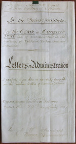
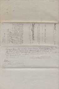
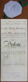
Document - Margaret Lord Letters of Administration 1890, 1896
This is an 1896 document containing the Letters of Administration following the death of Margaret Lord, a widow from Warrnambool. She died intestate in April 1896 and left real estate to the value of £15 and personal estate to the value of £250. The estate was to be administered by her son, John Lord, a draper from Warrnambool. Tait collection: item 13 of 62This document is of interest because it concerns a local Warrnambool woman, Margaret Lord and a local lawyer, Ernest Chambers The latter had offices in Warrnambool with the known dates 1896 to 1910, with other offices in Koroit and Port Fairy during the same period. His manager in Warrnambool was Thomas Goodall and this document with others was passed to lawyers occupying the same premises in Kepler Street and it was found in the buildings previously occupied by the legal firm Mackay Taylor.This is a piece of parchment paper folded in two with writing in brown-coloured ink on the back and front of the document. It has a seal of the Supreme Court of the Colony of Victoria and one red stamp of the Master in Equity of the Supreme Court. The writing is somewhat faded but still legible.‘In the Supreme Court of the Colony of Victoria, In the Probate Jurisdiction in the Estate of Margaret Lord, Late of Warrnambool in the Colony of Victoria, Widow, deceased, intestate, Letters of Administration. I certify that there is no duty payable on the within Letters of Administration, J. Poole, Officer Under Section 96 Act 1060, Dated the 22nd day of July 1896. E.J.W. Chambers, Proctor, Warrnambool’ margaret lord, ernest chambers, warrnambool -
 Bendigo Military Museum
Document - NOTICE to RECRUITS, Australian Military Forces, 4.6.1943
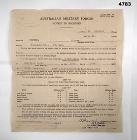
... documents ...The document is for Oliver Foster to report for a medical examination on 17th June 1943 at 8.30 in the fore noon,Document A.A.F.Mob.30, paper off white colour, “Notice to recruits” report for medical examination at Area 18B Hornsby 4.Jun.43, all print in black, typing in black, stamped top LH corner in purple & RH corner, hand signed in black pen, details at top have re person and where to report, bottom has list of items to bring if have them, rear is blank“FOSER Oliver, Rosedale Rd St Ives”notice, medical, documents -
 Kiewa Valley Historical Society
Map - Kiewa on the Map, Guide to Kiewa Hydro-Electric Project
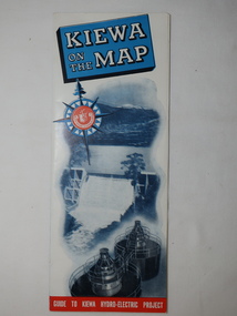
Published by the SECV in 1950. They controlled the roads from Mt Beauty to the Bogong High Plains and all other roads within the Kiewa works area. The roads are not open to general tourist traffic. Conducted tours of the Kiewa area are operated by Eastern Road Lines Pty. Ltd., AlburyThe SECV constructed the KHES and controlled all roads within the Kiewa works area.Large colored map folded in half and then in 3. Front third is mostly blue and white with titles.. When opened the cover has black and white photos beside it with print and 'Please Note'. Also in the other half, a 'Road Map to Kiewa' showing the south eastern side of Australia, mostly yellow (the land) and blue (the sea). Inside the map is a close up map of "Ground Plan of Kiewa Hydro Electric Project' with a 'Key Map Showing Distances'.map of kiewa 1950, khes map -
 Ballarat Tramway Museum
Map, Broadbent's, "Broadbent's Map 616 Ballarat", c1960
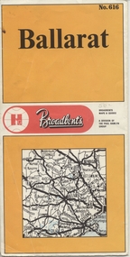
Yields information about the extent of Ballarat in the early to mid 1960's shows the tram lines and other rail lines in the district.Printed street map titled "Broadbent's Map 1616 Ballarat" printed in colour on one side only of a folded (10) sheet. Shows the suburbs of Ballarat, tram lines, has a scale in miles, Ballarat District map and an index to streets. Also points interest and historical interest. also shows railways lines. Map used as the base for the tram line map in the display area in the depot. Large Res scan made 28/1/2011."50c" in pencil on front cover.trams, tramways, map, ballarat, broadbent's, railways -
 Kew Historical Society Inc
Map, MMBW, River Yarra Beautification Schemes, c.1913
The Melbourne and Metropolitan Board of Works (MMBW) was established by an act of the Victorian Parliament in 1890 to prepare for and to implement a sewerage and water reticulation system across what was then inner Melbourne, its surrounding and middle distance suburbs, including Kew. The MMBW was disbanded in 1991.The map collection of the Kew Historical Society has at its core the historic maps assembled and originally stored in the City Engineer's Department of the City of Kew. These include maps in a number of scales. The vast majority of maps were produced by the MMBW in the first two decades of the twentieth century, and are solid working maps, backed by linen for durability. These maps are historically significant to Kew, the City of Boroondara and to the history of the development of state utilities in Victoria. A number of the Kew maps have additional details added by former municipal officers, including the levels reached by various floods. As these were working documents, information was added to them long after the period of their initial production and distribution.Map of the City of Kew showing part of the River Yarra Beautification Schemes. The map shows development to date and the flood levels reached in 1923 and 1924. This map may have been adapted from an earlier map, as most development in central Kew and Studley Park had occurred by this date yet numerous streets are not represented. Public buildings and institutions are clearly represented and named on the map as are significant public transport infrastructure (eg the Outer Circle railway).MELBOURNE AND METROPOLITAN BOARD OF WORKS / RIVER YARRA BEAUTIFICATION SCHEMES / SCHEME / SCALE 10 CHAINS TO AN INCHmelbourne & metropolitan board of works, mmbw maps, mmbw plans, city of kew, flood levels -- kew (vic.), cartography -
 University of Melbourne, Burnley Campus Archives
Plan, Keilor Planning Scheme, 1993
Photocopies. 18.02.1993. (1) 5 copies Map user guide - Keilor Planning Scheme, List of Zones Reservations and additional Planning Controls. (2) Keilor Planning Scheme - Local Section. Zones and Reserved Land Map No. 7. (3) Map No 9. Also 3 photocopies of maps joined together. Used in planning Native Garden Woodland Section.keilor, native garden, reservations, planning scheme, zoning, victoria department of planning and housing -
 Bendigo Historical Society Inc.
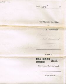
Document - MCCOLL, RANKIN AND STANISTREET COLLECTION: MINING LEASE NO 10173 GARDEN GULLY SHAFT, 9th March, 1934
Mining lease 5 page document for lease application 10173, dated 9th March 1934, within area bounded by Don, Barnard Streets up to Mt. Korong Road, area 10 acres. Document signed by John Jepson Stanistreet in the presence of W.A. Kell, Warden's Clerk, Bendigo. Hand coloured plan of lease appended to document, yellow section refers to lease. Marked on map Central Garden Gully shaft. On front of lease ' entered in the Register Book Vol 303 Fol 33698' On back ' His Majesty the King to J.P. Stanistreet (Cent G Gully not renewed written in pencil) Form C Gold Mining Lease Crown and Private Land'gold, mining, garden gully shaft -
 Bendigo Military Museum
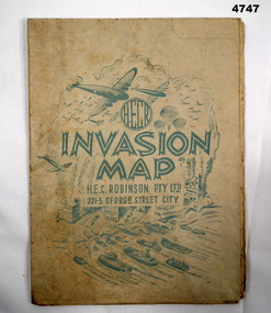
Map - INVASION MAP, H.E.C Robinson PTY LTD, Post 1945
... Maps ...Map, Robinsons Invasion Map of part of Europe rectangular shape, countries in seperate colours and boundaries in red, when folded has a front piece in blue showing planes, parachutes, boats and Cities, rear of the fold has a list of maps by Robinsonsmaps, invasion europe, robinsons -
 Bendigo Military Museum
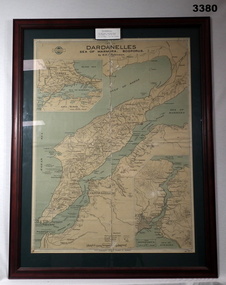
Map - MAP GALLIPOLI, FRAMED, H E C Robinson, Post WW1
Brown wooden frame with glass front. Coloured map of Dardanelles featuring the Sea of Marmara & The Bosporus. Mounted on green background with fawn cardboard backing. Map in scale of miles & kilometers. Map shows landings, ships sunk & events during 1915.Back of frame: “Bethany Gallery 116 Bridge Street Bendigo”map, framed, dardenelles, gallipoli, 1915 -
Glenelg Shire Council Cultural Collection
Map - Map - RACV Road Map, 1970s
RACV road map, Warrnambool District, Port Fairy to Lorne. Large coloured map of Warrnambool District. Small maps of Apollo Bay, Colac, Camperdown, Tower Hill and Warrnambool. When folded, black and white photo on cover of 12 Apostlesracv, road touring, road map, victoria -
Bendigo Historical Society Inc.
Map - CAMPBELL COLLECTION: BENDIGO AND DISTRICT MAPS
Map. Kimbolton, Parishes of Kimbolton and Lyell, scale 20 chains to 1 inch. Area by Planimeter 6258 acres. Knowsley. 10 1/2 miles to Strathfieldsaye. Campaspe River at bottom right of map. (number 365 in map cupboard 1)map, bendigo, allotments -
Whitehorse Historical Society Inc.
Map, Railway map of Victoria, 1912
... maps ...Detailed map of railways in Victoria including adjacent areas of New South Wales.Detailed map of railways in Victoria including adjacent areas of New South Wales. Also shows 'principal coach routes'. On verso map of suburban lines with eastern line as far as Croydon and Bayswater. key numbers on map linked to pages of a timetable.Detailed map of railways in Victoria including adjacent areas of New South Wales.maps, railways -
 Bacchus Marsh & District Historical Society
Map, Tracing of plan shewing portion through Bacchus Marsh District of proposed new Main Road between Gisborne and Blackwood
Road construction and planning was a primary function of the early local government authorities in rural and regional Victoria. This plan is indicative of the sort of documentation which generated considerable public interest and comment in rural communities. The date of this plan is not clear. Newspaper articles in the Bacchus Marsh Express around 1869 contain numerous references to the proposed new road between Gisborne and Blackwood which suggests this plan may date from the late 1860s or early 1870s.A single page paper map showing the proposed route of a main road to be constructed between Gisborne and Blackwood. The map is pasted into a bound volume containing 76 maps or plans in total. High resolution digital image stored on BMDHS computer network. roads, road plans, bacchus marsh victoria maps, gisborne to blackwood main road -
 Melbourne Tram Museum
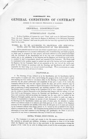
Document - Specification, George Duncan, Melbourne Tramways Trust, "General Conditions of Contract" - cable trams, c1884
Set of three printed foolscap documents, secured in the top left hand corner by a staple, giving standard "General Conditions of Contract" for the construction or provision of mechanical equipment to the Melbourne Tramways Trust, cable tram system. .1 - four page document - "General Construction" .2 - three page document - "Mechanical" .3 - two page document - has clause title on the left hand side.trams, tramways, mtt, cable trams, melbourne tramways trust, construction, mto co, contracts, specification, legal agreements -
 Warrnambool and District Historical Society Inc.
Document, Indenture A Bostock Esquire to Messrs Aitkin & Bostock( Ernest), 1865
The Bostock, Manifold and Aitkin families were all pioneering families in the Western District of Victoria almost from the time of settlement. They leased and owned vast tracts of land and operated businesses around the district, often associated with the farming industry. This document is dated 5th July 1865 and is an assignment of stock by way of mortgage. Augustus Bostock is the mortgagor with James William Manifold Aitkin and Ernest Bostock as mortgagees. At various times they were involved in running businesses together, in particular the Aitkin and Bostock store and flour mill. Three of the Bostock men were married to three of the Aitkin sisters. The amount in question is £2157/3/2 and surety is 8000 sheep and their increase, presently running at Coomete. The penciled in details on the document refer to Robert Brand Paterson who was later in business with Aitkin This is one of a number of documents which relate to the Bostock family who were one of the most important pioneering families of the Western District. They owned and leased various properties around Warrnambool and were involved in many aspects of social and business life. The document itself is indicative of its time and provides an insight into the details and terms of such documents at the time.Large grey coloured, lined hand written document over four pages. Folded in four with date and details on one section. Red wax seal on page 3. There are extra entries written in black lead pencil in areas relating to the money and surety of the agreement.Signed by the following George Barber Warrnambool, Thomas Sunderland Deputy Registrar General, and Augustus Bostock. Hingston & Co, Chancery Lane Melbourne hand written in top left hand corner. warrnambool, bostock,augustus bostock james william manifold aitkin,robert brand paterson, coomete, -
 Warrnambool and District Historical Society Inc.
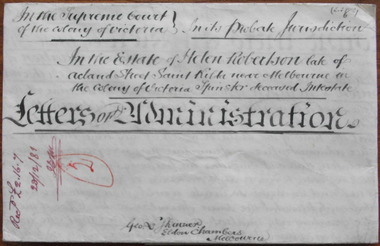
Document - Helen Robertson Letters of Administration 1881, 1889
Tait collection: item 34 of 62 This is a document giving the details of the Letters of Administration following the death of Helen Robertson, a spinster from St. Kilda, Melbourne. She died intestate in November 1881 and left property to the value of £363. This property reverted to her sister Agnes Thomson in 1889. No other details have been found on Helen Robertson. The lawyer in the case was George Skinner of Melbourne but the document was one of several stored in legal premises in Kepler Street, Warrnambool and passed on to successive lawyers occupying these premises. It was located in the same building, the former premises of the legal firm, Mackay Taylor, in 2014 and handed over to the Warrnambool and District Historical Society.This document is of minor interest as one located in former legal premises in Warrnambool but no other connection has been found between Warrnambool and the person whose details are in the document, Helen RobertsonThis is a cream-coloured piece of parchment paper folded at the bottom edge and containing hand written material on both sides of the paper. The contents give details of the Letters of Administration following the death of Helen Robertson in 1881. A seal of the Supreme Court of Victoria is attached with green ribbon. The document is somewhat stained.In the Supreme Court of the colony of Victoria in its Probate Jurisdiction in the Estate of Helen Robertson late of Acland Street Saint Kilda near Melbourne in the Colony of Victoria Spinster deceased intestate Letters of Administrationhelen robertson, george skinner -
![Book, Dept. of Veterans' Affairs, Fromelles and the Somme: Australians on the Western Front [by] Peter Burness, 2006](/media/collectors/4f729f7b97f83e03086018a5/items/593a0b96d0cdd11b444cd457/item-media/5bac2dd121ead11568b486e3/item-fit-380x285.jpg) Eltham District Historical Society Inc
Eltham District Historical Society IncBook, Dept. of Veterans' Affairs, Fromelles and the Somme: Australians on the Western Front [by] Peter Burness, 2006
The numbers are distressing, even a century later - on the Western Front in France during the Great War some 265,000 Australians served against the enemy - more than 46,000 of them lost their lives, many thousands more injured, This book tells some of the story - Review by http://www.diversitybooks.com.auSoftcover 80 p. : chiefly ill., maps, ports, captioned illustrations (AWM Archives) throughout, plus a line-drawn map. Covered in plasticISBN 1920720693fromelle, somme, world war 1914-1918, military campaign -
Bendigo Historical Society Inc.
Map - PORTION OF ELMORE ESTATE, 19/10/1920
Map: Portion of Elmore Estate, Parishes of Warragamba and Diggorra, County of Bendigo. Parish plan Canvas backed ( number 143 in Map Cupboard 1)map, bendigo, rural, elmore estate , warragamba, diggorra , county of bendigo. -
Bendigo Historical Society Inc.
Map - MAHER'S AND PRETTY'S ESTATE, 8/02/1926
Map: Maher's and Pretty's Estate, Parish of Toolamba West, County of Rodney. Parish plan Canvas backed. ( number 131 in Map Cupboard 1)map, rodney, rural, maher's , pretty's, toolamba west, county of rodney -
Bendigo Historical Society Inc.
Map - BURNEWANG PARK ESTATE, circa 1920
Map: Burnewang Park Estate, Parishes of Diggorra and Minto, County of Bendigo, Parish Plan ,Canvas backed ( number 127 in Map Cupboard 1)map, bendigo, rural, burnewang, diggorra, minto, county of bendigo -
Bendigo Historical Society Inc.
Map - SANDHURST GOLD FIELD SHEET NO. 1, 18th June 1873
Map: Sandhurst Gold Field sheet No. 1, Showing lands held under lease for Gold Mining ( number 221 in Map Cupboard 1)map, bendigo, mining plan, sandhurst gold field, lease for gold mining -
Bendigo Historical Society Inc.
Map - CITY OF BENDIGO (PART), Circaa 1900
Map: parish plan showing an area North West oh Napier St., Weeroona Ave. intersection ( number 216 in Map Cupboard 1)map, bendigo, parish plan, bendigo, napier st, weeroona avenue -
Bendigo Historical Society Inc.
Map - SANDHURST (PART), Circa 1880's
Map: Parish plan showing a section of the city of Sandhurst, Northwards from Lloyd St. East bendigo. ( number 212 in Map Cupboard 1)map, bendigo, parish plan, lloyd st. sandhurst, bendigo -
Bendigo Historical Society Inc.
Map - KAMAROOKA STATE FOREST, 23/11/1910
Map: Part of Subdivision of kamarooka State Forest, Parishes of Neilborough and Whirrakee, County of Bendigo. Parish plan (number 287 in map cupboard 1)map, bendigo, subdivision, kamarooka state forest, subdivision, whirrakee -
Bendigo Historical Society Inc.
Map - PART OF ELLESMERE, 20/06/1875
Map: Re-survey of part of the Parish of Ellesmere, hand draughted Parish plan Reloacated to Map Drawer 5 on 22.9.2022. Hanging strip detached.map, bendigo, parish plan, ellesmere -
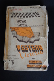 Anglesea and District Historical Society
Road Directory, Broadbent's Official Road Guides Company, Broadbent's Official Road Guide Western Victoria, 1956
... Maps ...Contains maps and advertisements for Western Victoria in 1956 as well as some of South-East of South Australia. 240 pages. Fold out maps included.Circa 1956maps, advertisements, broadbent -
 Warrnambool and District Historical Society Inc.
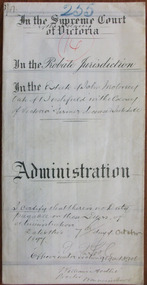
Document - John Moloney Letters of Administration 1897, 1897
Tait collection: item 43 of 62 This is a document giving details of the Letters of Administration of John Moloney, a farmer from Bushfield, who died in July 1897. He died intestate but had real estate to the value of £510 and personal estate to the value of £142. The beneficiary was his wife, Mary Ann Moloney. The lawyer involved in drawing up this document was William Ardlie, one of the best-known lawyers in Warrnambool in the 19th and 20th centuries. He commenced his business in the 1860s and continued on until the 1930s when he was well in his eighties, making him at the time the oldest practising lawyer in Australasia. The document seemed to have been passed down by successive lawyers occupying the Kepler Street legal premises and located there in 2014.This document is of some interest as it gives details of the Letters of Administration of John Moloney, a 19th century farmer from Bushfield and it also concerns the lawyer, William Ardlie, a prominent Warrnambool lawyer at that time. It will be useful for researchers.This is a piece of cream-coloured thin parchment paper folded in two. It has handwritten material on two pages (black ink) containing details of the Letters of Administration following the death of John Moloney of Bushfield in 1897. A seal of the Supreme Court of Victoria is attached with green ribbon and there is one red stamp of the Master in Equity of the Supreme Court. The document is somewhat dirty but quite legible. The numbers ‘255’ and ‘14’ are written in blue pencil on the back page. In the Supreme Court of the Colony of Victoria In the Probate Jurisdiction In the Estate of John Moloney late of Bushfield in the Colony of Victoria Farmer deceased Intestatejohn moloney, warrnambool, william ardlie, bushfield, tait collection -
Mission to Seafarers Victoria
legal record (item) - Register, Marriages, The Victoria Missions to Seamen, Marriage Register, 1950
The register documents the weddings that took place in St. Peter's Mariners Church between October 1950 to January 1954. Each page is the legal documentation of the necessary information for the wedding to be registered in the Commonwealth of Australia. Two of the weddings registers also have Forms of Consent, as the brides were under age. Most of the weddings have been officiated by Reverend Frank Oliver.The register is a record of the weddings conducted in Peter the Marina Church between the 14th of October 1950 to the 16th of January 1954.On unattached front cover: REGISTER NO 7 (underlined) / 106 - 130 / 14-10-50 - 16-1-54 / NOTE NOS 107 PORT MELBOURNE / 114 WILLIAMSTOWN / 122 WILLIAMSTOWN / 120 PRIVATE ADDRESS GLENHUNTLY, handwritten in ink. There is an ink smudge just below the last line.wedding, marriage, 1950-1954, register, mission-to-seafarers, mission to seafarers, mission to seamen, seamen's mission, marriages, weddings, chapel, st peter chapel, padre oliver, dio-marriages, dio-archives -
 Warrnambool and District Historical Society Inc.
Document - Patrick White Probate 1897, 1897
Tait collection: item 42 of 62 This is a document giving details of the Will and Probate of Patrick White, a farmer from Codrington who died in 1883. He left personal estate to the value of £316, with the beneficiaries being his wife, Eleanor and his son George. The lawyer concerned with this document was Ernest Chambers who had legal offices in Port Fairy, Koroit and Warrnambool at the end of the 19th century and the beginning of the 20th century. He had possession of this document and it was passed down to successive lawyers occupying the legal premises in Kepler Street, Warrnambool and located in this Kepler Street building in 2014. This document is of minor significance as Patrick White was not a resident of Warrnambool. The interest lies in the fact that the lawyer, Ernest Chambers, practised in Warrnambool in the 19th centuryThis is a cream-coloured piece of parchment paper containing details of the Will and Probate of Patrick White of Codrington who died in 1883. The paper is folded in two and the edges of the pages have blue lines ruled on them. There is handwritten material (black ink) on three of the pages. The seal of the Supreme Court of Victoria is attached with olive-green ribbon and there are five red stamps of the Master in Equity of the Supreme Court. The writing is fading in places but the document is readable. In the Supreme Court of the Colony of Victoria In the Probate Jurisdiction In the Will of Patrick White late of Codrington in the Colony of Victoria Farmer deceasedpatrick white,, codrington, ernest chambers, warrnambool history -
 Dandenong/Cranbourne RSL Sub Branch
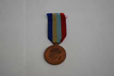
Medal - Assorted UN and other medals
The United Nations Forces have been present and involved in many conflicts throughout the world. Conflicts include:- Unimil Liberia - Korea - Unamic Cambodia - Onuc Congo - Onusal El Salvador-Unikom Kuwait - Unomig Georgia - Unifil Lebanon - Unpredep Yugoslavia - Onuca Nicaragua & Guatemala Netherlands New Guinea.Circular medals with variously colored ribbons. Nigerian National Service Medal. Great Britain WW 2 India Service Medal 1939 - 1945. Canada WW 2 Service Medal 1939 - 1945.U N medals have stylised Map of the World on the obverse surrounded by laurel leaves and letters UN above. The reverse has the wording " In The Service Of Peace." Nigerian National Service Medal obverse shows map of Nigeria surrounded by wording "Nigeria National Service Medal 1966 - 1970."Reverse shows map of Nigeria in centre "eagle holding star" above -anchor on left - "eagle over laurel leaves on right" and an elephant below. India Service Medal obverse shows George the 6th. Reverse has map of India in centre, INDIA above map and the dates 1939 -45 below map. Canada Service Medal obverse has group of servicemen in centre " Voluntary Service 1939 Canada 1945" in English and French. Reverse shows Canadian Coat of Arms.