Showing 8861 items matching " construction"
-
 National Vietnam Veterans Museum (NVVM)
Photograph, Gibbons, Denis, Ap Sui Nge Refugee Village
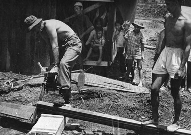
Denis Gibbons (1937 – 2011) Trained with the Australian Army, before travelling to Vietnam in January 1966, Denis stayed with the 1st Australian Task Force in Nui Dat working as a photographer. For almost five years Gibbons toured with nine Australian infantry battalions, posting compelling war images from within many combat zones before being flown out in late November 1970 after sustaining injuries. The images held within the National Vietnam Veterans Museum make up the Gibbons Collection.A black and white photograph of A Digger from 1st Australian Civil Affairs Unit stationed at 1st ATF Base in Phuoc Tuy Province assisted by a villager cuts timber for house construction during the building of the Ap Sui Nge Refugee Village. The village was designed by the officers and men of the 1st Australian Civil Affairs Unit and built as a major project involving Task Force Unitsphotograph, 1st australian civil affairs unit, 1st atf base, phuoc tuy province, ap sui nge village, gibbons collection catalogue, digger, 1st australian task force, denis gibbons -
 Eltham District Historical Society Inc
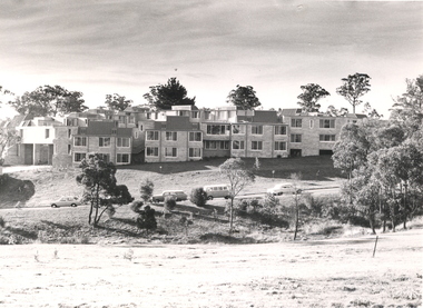
Slide, Shalbury Avenue, Eltham, c. Jan 1983
Roll of film taken by Eltham Shire Council officers of the Beard street group, a private street scheme, before construction commenced. They provide perspective of the changes in housing styles and road development that began sweeping in from the mid 1970s with increasing urbanisation of what was once more outlying suburbs and regions.35 mm colour positive transparency (1 of 7) Mount - Blank Card,eltham, housing estate, infrastructure, private street scheme, roads, shalbury avenue -
 Eltham District Historical Society Inc
Slide, Andrews Street, Eltham, c. Jan 1983
Roll of film taken by Eltham Shire Council officers of the Beard street group, a private street scheme, before construction commenced. They provide perspective of the changes in housing styles and road development that began sweeping in from the mid 1970s with increasing urbanisation of what was once more outlying suburbs and regions.35 mm colour positive transparency (1 of 7) Mount - Blank Card,eltham, housing estate, infrastructure, private street scheme, roads, andrews street -
 Eltham District Historical Society Inc
Slide, Thomas Street, Eltham, c. Jan 1983
Roll of film taken by Eltham Shire Council officers of the Beard street group, a private street scheme, before construction commenced. They provide perspective of the changes in housing styles and road development that began sweeping in from the mid 1970s with increasing urbanisation of what was once more outlying suburbs and regions.35 mm colour positive transparency (1 of 7) Mount - Blank Card,eltham, housing estate, infrastructure, private street scheme, roads, thomas street -
 Eltham District Historical Society Inc
Slide, Andrews Street, Eltham, c. Jan 1983
Roll of film taken by Eltham Shire Council officers of the Beard street group, a private street scheme, before construction commenced. They provide perspective of the changes in housing styles and road development that began sweeping in from the mid 1970s with increasing urbanisation of what was once more outlying suburbs and regions.35 mm colour positive transparency (1 of 7) Mount - Blank Card,eltham, housing estate, infrastructure, private street scheme, roads, andrews street -
 Eltham District Historical Society Inc
Slide, Frank Street, Eltham, c. Jan 1983
Roll of film taken by Eltham Shire Council officers of the Beard street group, a private street scheme, before construction commenced. They provide perspective of the changes in housing styles and road development that began sweeping in from the mid 1970s with increasing urbanisation of what was once more outlying suburbs and regions.35 mm colour positive transparency (1 of 7) Mount - Blank Card,eltham, housing estate, infrastructure, private street scheme, roads, frank street -
 Eltham District Historical Society Inc
Slide, Beard Street, Eltham, c. Jan 1983
Roll of film taken by Eltham Shire Council officers of the Beard street group, a private street scheme, before construction commenced. They provide perspective of the changes in housing styles and road development that began sweeping in from the mid 1970s with increasing urbanisation of what was once more outlying suburbs and regions.35 mm colour positive transparency (1 of 7) Mount - Blank Card,eltham, housing estate, infrastructure, private street scheme, roads, frank street, beard street -
 Federation University Historical Collection
Photograph - Black and White Photographs, Views of Mount Helen Campus, c1973
Ongoing photgraphic record of Mount Helen Campus development. A contract for the construction of Student housing, Union building (later Albert Coates Complex), and a four storey library (later E.J.. Barker Library) on the Mt Helen campus was signed in November and December 1971. They were all completed and occupied in 1973. Views of Mount Helen Campus .1) Signposts of first turnoff campus road from Gear Avenue .2) Mount Helen Student Residences (stage 1) .3) Rear view of Mount Helen Student Residences (Stage 1)mount helen campus, buildings, student residences -
 Greensborough Historical Society
Report, Examining Draughtsman's Report - Watts River Aqueduct, 20/07/1897
This Field Survey was commissioned by the Melbourne Board of Works and was used to position the Maroondah Aqueduct bridge north of Greensborough at its crossing point on the Plenty River. It incorporated the use of wrought iron water pipes and therefore is of lighter construction than other similar bridges in the district. It features a traverse of the Plenty RiverThe Maroondah Aqueduct bridge is a significant example of late 19th century engineering. A 4 page reproduction of an Office of Titles document. Copy of handwritten report includes maps.maroondah aqueduct, watts river aqueduct, bridge, greensborough, office of titles, 1897, wrought iron water pipes, plenty river, melbourne board of works -
 Eltham District Historical Society Inc
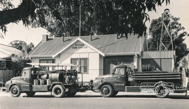
Photograph, Hugh Fisher, Eltham Fire Station, east side of Main Road, 1950s, 1950s
The Eltham Fire Station was opened in 31 April 1935. Years later the building was removed and erected for use of 1st Research Scout Group in Research Park by the early 1970s to make way for the Eltham Village Complex which was under construction by 1971. The Research Scout Hall was destroyed by fire in 2002.Black and white photographPhoto by Hugh Fischer, c.1950seltham, fire station, main road -
 Bendigo Historical Society Inc.
Booklet - St Liborius Primary School No.262 - 100 Years 1904-2004, 2005
St. Liborius Catholic scholl No 262 began construction in June 1904, with the foundations stone being laid 19th June 1904 by the Most Rev S Reville, Lord Bishop of Sandhurst. It was designed by Bendigo architects Keogh and Austen of View Point and was built by local builder W E Brown.120-page soft cover booklet 'St Liborius Primary School No.262, 100 Years 1904-2004' Yellow and brown covers with pictures of the school on front and back. Compiled by Aylene Kirkwood. Printed by Richard Cambridge Printers, Bendigo A history of the school illustrated with B&W photos of the staff, students and clergy. Lists of teachers and staff from 1979 plus a comprehensive index at the back. Foreword by the Bishop of Sandhurst, Joseph Grech. st liborius, primary school -
 Lake Bolac & District Historical Society
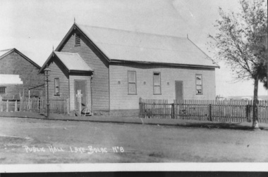
Photograph - Black and white photograph, Lake Bolac Public Hall 1896, 1896
Lake Bolac Public Hall, Mongomery Street in 1896. Weatherboard construction by Mr Ollie Anderson of Ararat. Opened by district MP Mr McLellan. In 1922 this building was relocated across Montgomery Street to become the supper room for the newly erected Memorial Hall honouring World War 1 soldiers.black and white photographlake bolac, public hall, montgomery street, ollie anderson, mr mclellan -
 Kew Historical Society Inc
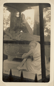
Postcard, Springthorpe Memorial, Boroondara General (Kew) Cemetery, 1918-1935
The Springthorpe Memorial is an elaborate late 19th century memorial located within Boroondara General Cemetery. Harold Desbrowe-Annear designed the memorial for the Melbourne doctor John Springthorpe, in honour of the doctor’s wife. Construction began in 1897, and the memorial was unveiled in 1901. On the sarcophagus is sculpted group of figures by Bertram Mackennal. Rare postcard showing details of the figurative group o n the monument and its original glass case.This close-up of two of the figures shows an angel leaning over the representation of Dr John Springthorpe’s wife. The postcard is historically interesting in that it shows the wreath, which is now missing.springthorpe memorial, boroondara general cemetery, bertram mackennnal -- sculptor, funerary monuments -
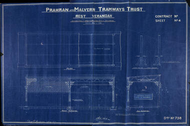 Melbourne Tram Museum
Drawing, Prahran & Malvern Tramway Trust (PMTT), "Rest Verandah - PMTT", 19-12-1916
Drawing by the Prahran and Malvern Tramways Trust No. 758, of the Rest Verandah or shelter at Victoria St terminus or the change point from cable to electric tram Richmond. Dated 19-12-16, signed by H Dix Engineer and ? R Henderson Construction Engineer. Details the structure, foundations, and shelter decoration.Yields information about the Victoria St shelter at the terminus of the cable tram line.Drawing - blue print on paper.trams, tramways, pmtt, shelters, cable trams, victoria st, richmond -
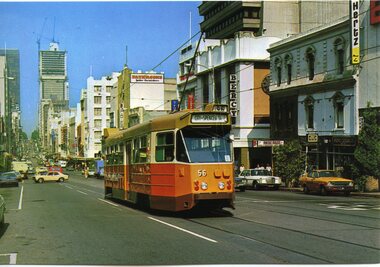 Melbourne Tram Museum
Postcard - Bourke St Melbourne, National View by Murfett Publishing, 1980c
National View postcard of Z1 56 westbound in Bourke St. Tram has the destination of City Spencer St, route 96, c1980. The building that became the National Australia Bank in Bourke St is under construction. Has building signs for Patersons Furnishings, Bercy Theatre, Hertz rent cars.Yields information about Bourke St and Z1 class tramsPostcard - by National View by Murfett Pty Ltd - divided back with title and publisher details. Card No. P1004-1trams, tramways, bourke st, z1 class, tram 56 -
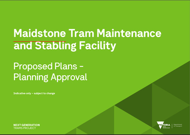 Melbourne Tram Museum
Document, Maidstone Tram Maintenance and Stabling Facility - Proposed Plans - Planning Approval
Provides the proposed plans for the Maidstone Tram Maintenance and Stabling Facility - Proposed Plans - Planning Approval stage - site plans, perspective, land use and sight lines from various locations. The information booklet looks at the project steps, planning approval, heritage issues, environmental, construction, timing and operations.Yields information about the proposed Maidstone tram depot.Digital copy of a 13 A3 page document titled - Maidstone Tram Maintenance and Stabling Facility - Proposed Plans - Planning Approval and a 12 A4 page Information booklettrams, maidstone, tramways, new depot -
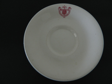 Kiewa Valley Historical Society
Saucer Ceramic, c1921
The SECV had chalets, cafes, mess halls and tea rooms all over Victoria including their construction sites. The SECV had a stores system which purchased thousands of sets of crockery and cutlery for use by personnel. There was a system of chefs, cooks, tea persons etc. to supply food and beverages to the workers. This saucer was used at one of the sites on the Kiewa Hydro Electric Scheme.Heavy, white ceramic saucer with State Electricity Commission of Victoria 1921 log/insignia on inside lip. Curves up to sides. On base, also inscribed in red are details of the makers.State Electricity Commission Victoria / 1921 On base: Vitrified / Sold by / Cafe & Hotel Supplies / Pty Ltd / DunnBennett & Co. ITC / Burslem / Made in Englandkiewa hydro electric scheme. mount beauty chalet. bogong mess hall. state electricity commission of victoria. crockery. -
 Kiewa Valley Historical Society
Photo - Bogong Township, March 1944
In 1940 Field Headquarters for the Kiewa Scheme were established at Bogong with office, workshop facilities and accommodation for workmen, staff and some families constructed. (There had been a 'tent camp' on this site in 1939 but was destroyed by bushfires) Construction of accommodation continued until 1947. A total of 40 houses plus a hostel for single staff, post office, police station, medical centre and primary school all with water and sewerage and electricity supply. The staff hostel was known as Kiewa House and is now occupied by the Education Department. Lake Guy was named after Mr. L.T. Guy who was the Resident Engineer in charge of construction work and associated activities on the Kiewa area. He held this position from 1939 to November 1946 when he was transferred to Head Office. The Bogong Township was developed firstly as an accommodation centre (base camp) for construction workers employed under the Kiewa Hydroelectric Scheme. Due to the influx of European workers into the Township the beautification of the immediate surrounds (gardens etc.) had a distinct European flavour. This environment has been very beneficial for tourism in later years. At the completion of the scheme, in the 1960's, the village was opened to public/tourism use. Strict environmental control has not allowed for any extensive redevelopment in tourist accommodation and basically restricted it to the accommodation initially built for the construction workers. Activities such a bike riding, snow skiing, restricted horse riding and bush walking on the Alpine plains and mountains are now a viable part of the Kiewa Valley Tourist Industry. The lake is one of the many water storage reservoirs used to supply the power stations their main power to run the huge turbines generating the final product, electricityBlack and white photograph of Bogong Township taken March 1944Handwritten on the back of photo - Township March '44bogong village, secv -
 Kiewa Valley Historical Society
Photograph - Bogong Village (7 copies), Approx 1940
In 1940 Field Headquarters for the Kiewa Scheme were established at Bogong with office, workshop facilities and accommodation for workmen, staff and some families constructed. (There had been a 'tent camp' on this site in 1939 but was destroyed by bushfires) Construction of accommodation continued until 1947. A total of 40 houses plus a hostel for single staff, post office, police station, medical centre and primary school all with water and sewerage and electricity supply. The staff hostel was known as Kiewa House and is now occupied by the Education Department. Lake Guy was named after Mr. L.T. Guy who was the Resident Engineer in charge of construction work and associated activities on the Kiewa area. He held this position from 1939 to November 1946 when he was transferred to Head Office. The Bogong Township was developed firstly as an accommodation centre (base camp) for construction workers employed under the Kiewa Hydroelectric Scheme. Due to the influx of European workers into the Township the beautification of the immediate surrounds (gardens etc.) had a distinct European flavour. This environment has been very beneficial for tourism in later years. At the completion of the scheme, in the 1960's, the village was opened to public/tourism use. Strict environmental control has not allowed for any extensive redevelopment in tourist accommodation and basically restricted it to the accommodation initially built for the construction workers. Activities such a bike riding, snow skiing, restricted horse riding and bush walking on the Alpine plains and mountains are now a viable part of the Kiewa Valley Tourist Industry. The lake is one of the many water storage reservoirs used to supply the power stations their main power to run the huge turbines generating the final product, electricity. Evidence can be seen of the 1939 bushfires.Set of 7 identical black and white photographs of Bogong Village after 1939 bush firesHandwritten on the back of one photo - Bogong Village approx. 1940, after 1939 bush fires. Staff residences to left. Kiewa House, General offices and test lab to the right. Hand drawn map on the back of one photo.bogong village, secv -
 Kiewa Valley Historical Society
Photo - Bogong Village Township, October 8, 1946
In 1940 Field Headquarters for the Kiewa Scheme were established at Bogong with office, workshop facilities and accommodation for workmen, staff and some families constructed. (There had been a 'tent camp' on this site in 1939 but was destroyed by bushfires) Construction of accommodation continued until 1947. A total of 40 houses plus a hostel for single staff, post office, police station, medical centre and primary school all with water and sewerage and electricity supply. The staff hostel was known as Kiewa House and is now occupied by the Education Department. Lake Guy was named after Mr. L.T. Guy who was the Resident Engineer in charge of construction work and associated activities on the Kiewa area. He held this position from 1939 to November 1946 when he was transferred to Head Office. The Bogong Township was developed firstly as an accommodation centre (base camp) for construction workers employed under the Kiewa Hydroelectric Scheme. Due to the influx of European workers into the Township the beautification of the immediate surrounds (gardens etc.) had a distinct European flavour. This environment has been very beneficial for tourism in later years. At the completion of the scheme, in the 1960's, the village was opened to public/tourism use. Strict environmental control has not allowed for any extensive redevelopment in tourist accommodation and basically restricted it to the accommodation initially built for the construction workers. Activities such a bike riding, snow skiing, restricted horse riding and bush walking on the Alpine plains and mountains are now a viable part of the Kiewa Valley Tourist Industry. The lake is one of the many water storage reservoirs used to supply the power stations their main power to run the huge turbines generating the final product, electricityBlack and white photograph of Bogong Village which appeared in the Herald Sun newspaper on October 8, 1946. Page 13Handwritten on the back - Town of Bogong on a rugged mountain slope above Lake Guy. State Electricity Committee workers on the Kiewa Hydro Electric scheme live here in all electric homes. Stamped on the back - Copyright Not for reproduction Herald Sun Feature Service Melbourne Australiabogong village; lake guy; kiewa hydro electric scheme -
 Kiewa Valley Historical Society
Postcard - Lake Guy and Bogong Village
In 1940 Field Headquarters for the Kiewa Scheme were established at Bogong with office, workshop facilities and accommodation for workmen, staff and some families constructed. (There had been a 'tent camp' on this site in 1939 but was destroyed by bushfires) Construction of accommodation continued until 1947. A total of 40 houses plus a hostel for single staff, post office, police station, medical centre and primary school all with water and sewerage and electricity supply. The staff hostel was known as Kiewa House and is now occupied by the Education Department. Lake Guy was named after Mr. L.T. Guy who was the Resident Engineer in charge of construction work and associated activities on the Kiewa area. He held this position from 1939 to November 1946 when he was transferred to Head Office. The Bogong Township was developed firstly as an accommodation centre (base camp) for construction workers employed under the Kiewa Hydroelectric Scheme. Due to the influx of European workers into the Township the beautification of the immediate surrounds (gardens etc.) had a distinct European flavour. This environment has been very beneficial for tourism in later years. At the completion of the scheme, in the 1960's, the village was opened to public/tourism use. Strict environmental control has not allowed for any extensive redevelopment in tourist accommodation and basically restricted it to the accommodation initially built for the construction workers. Activities such a bike riding, snow skiing, restricted horse riding and bush walking on the Alpine plains and mountains are now a viable part of the Kiewa Valley Tourist Industry. The lake is one of the many water storage reservoirs used to supply the power stations their main power to run the huge turbines generating the final product, electricityBlack and white photographic postcard of Lake Guy and Bogong Village. Kiewa Hydro electric Project (showing Junction Dam in front)Handwritten on the back of postcard ' Like most of our camps, this looks like something from the Canadian Rockies' Stamped on the back - Valentine's Post Card A genuine photographlake guy, bogong village, secv -
 Kiewa Valley Historical Society
Photo - Bogong Township, September 1953
In 1940 Field Headquarters for the Kiewa Scheme were established at Bogong with office, workshop facilities and accommodation for workmen, staff and some families constructed. (There had been a 'tent camp' on this site in 1939 but was destroyed by bushfires) Construction of accommodation continued until 1947. A total of 40 houses plus a hostel for single staff, post office, police station, medical centre and primary school all with water and sewerage and electricity supply. The staff hostel was known as Kiewa House and is now occupied by the Education Department. Lake Guy was named after Mr. L.T. Guy who was the Resident Engineer in charge of construction work and associated activities on the Kiewa area. He held this position from 1939 to November 1946 when he was transferred to Head Office. The Bogong Township was developed firstly as an accommodation centre (base camp) for construction workers employed under the Kiewa Hydroelectric Scheme. Due to the influx of European workers into the Township the beautification of the immediate surrounds (gardens etc.) had a distinct European flavour. This environment has been very beneficial for tourism in later years. At the completion of the scheme, in the 1960's, the village was opened to public/tourism use. Strict environmental control has not allowed for any extensive redevelopment in tourist accommodation and basically restricted it to the accommodation initially built for the construction workers. Activities such a bike riding, snow skiing, restricted horse riding and bush walking on the Alpine plains and mountains are now a viable part of the Kiewa Valley Tourist Industry. The lake is one of the many water storage reservoirs used to supply the power stations their main power to run the huge turbines generating the final product, electricityBlack and white photograph of Bogong Township taken from Little Arthur fire track. September 1953Faded handwritten inscription on back - Bogong Township taken from Little Arthur fire track. Sept 1953bogong village, secv -
 Kiewa Valley Historical Society
Photo - First Bogong Camp, September 1950
In 1940 Field Headquarters for the Kiewa Scheme were established at Bogong with office, workshop facilities and accommodation for workmen, staff and some families constructed. (There had been a 'tent camp' on this site in 1939 but was destroyed by bushfires) Construction of accommodation continued until 1947. A total of 40 houses plus a hostel for single staff, post office, police station, medical centre and primary school all with water and sewerage and electricity supply. The staff hostel was known as Kiewa House and is now occupied by the Education Department. Lake Guy was named after Mr. L.T. Guy who was the Resident Engineer in charge of construction work and associated activities on the Kiewa area. He held this position from 1939 to November 1946 when he was transferred to Head Office. The Bogong Township was developed firstly as an accommodation centre (base camp) for construction workers employed under the Kiewa Hydroelectric Scheme. Due to the influx of European workers into the Township the beautification of the immediate surrounds (gardens etc.) had a distinct European flavour. This environment has been very beneficial for tourism in later years. At the completion of the scheme, in the 1960's, the village was opened to public/tourism use. Strict environmental control has not allowed for any extensive redevelopment in tourist accommodation and basically restricted it to the accommodation initially built for the construction workers. Activities such a bike riding, snow skiing, restricted horse riding and bush walking on the Alpine plains and mountains are now a viable part of the Kiewa Valley Tourist Industry. The lake is one of the many water storage reservoirs used to supply the power stations their main power to run the huge turbines generating the final product, electricityBlack and white photo of Bogong Village. September 1950Handwritten on the back - 1st Bogong Camp. SEC Kiewa Scheme Sept 1950bogong camp, bogong village, secv -
 Kiewa Valley Historical Society
Photo - Bogong Village Township
In 1940 Field Headquarters for the Kiewa Scheme were established at Bogong with office, workshop facilities and accommodation for workmen, staff and some families constructed. (There had been a 'tent camp' on this site in 1939 but was destroyed by bushfires) Construction of accommodation continued until 1947. A total of 40 houses plus a hostel for single staff, post office, police station, medical centre and primary school all with water and sewerage and electricity supply. The staff hostel was known as Kiewa House and is now occupied by the Education Department. Lake Guy was named after Mr. L.T. Guy who was the Resident Engineer in charge of construction work and associated activities on the Kiewa area. He held this position from 1939 to November 1946 when he was transferred to Head Office. The Bogong Township was developed firstly as an accommodation centre (base camp) for construction workers employed under the Kiewa Hydroelectric Scheme. Due to the influx of European workers into the Township the beautification of the immediate surrounds (gardens etc.) had a distinct European flavour. This environment has been very beneficial for tourism in later years. At the completion of the scheme, in the 1960's, the village was opened to public/tourism use. Strict environmental control has not allowed for any extensive redevelopment in tourist accommodation and basically restricted it to the accommodation initially built for the construction workers. Activities such a bike riding, snow skiing, restricted horse riding and bush walking on the Alpine plains and mountains are now a viable part of the Kiewa Valley Tourist Industry. The lake is one of the many water storage reservoirs used to supply the power stations their main power to run the huge turbines generating the final product, electricityBlack and white photograph of Bogong Village from across Lake Guy. Photo mounted on buff cardbogong village, secv -
 Kiewa Valley Historical Society
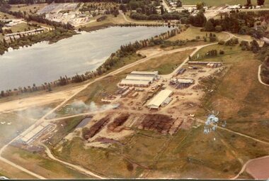
Photograph - Mt Beauty timber Industries, 1960's (estimate only)
Hume and Hovell discovered the area in 1824 and by the end of the 19th century the valley was transformed by logging, dairy and beef cattle properties and tobacco farms. Timber was required for construction of McKay Creek Power Station which began construction in 1951 and also the camps and houses for the workers and their families. There was a need for housing and infrastructure for an increasing population of workers for the hydro-electric scheme as there was a general shortage of this commodity. A timber mill was started in Tawonga by Mates, of Albury, in 1945, and electricity became available in 1946 the S.E.C. bought the mill, and enlarged it. In 1960 it was purchase by a local family. They also started a timber mill in Mt Beauty and worked both until 1980 when they closed the Tawonga mill and enlarged the mill called Mt. Beauty Timbers Pty Ltd which employed approximately 50 people. A pictorial record of the development of the Mt Beauty community and the local timber industry.Colour photograph of aerial view of Mt Beauty Timber Mills and surrounding area including pondage and part of airfield. Photo taken in 1960’s (estimate only)Handwritten in ink on back of photograph in very faint writing – Recent photo of Mt Beauty Timber Industries Mt Beauty Operationsmt beauty timber industry, timber industry, timber mill, secv -
 Kiewa Valley Historical Society
Photograph - Mount Beauty Timber Industries, 1960's (estimate only)
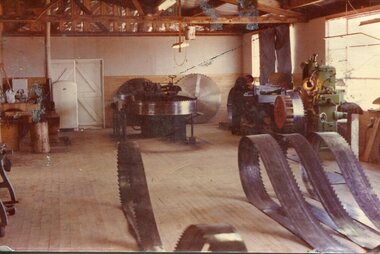
Hume and Hovell discovered the area in 1824 and by the end of the 19th century the valley was transformed by logging, dairy and beef cattle properties and tobacco farms. Timber was required for construction of McKay Creek Power Station which began construction in 1951 and also the camps and houses for the workers and their families. There was a need for housing and infrastructure for an increasing population of workers for the hydro-electric scheme as there was a general shortage of this commodity. A timber mill was started in Tawonga by Mates, of Albury, in 1945, and electricity became available in 1946 the S.E.C. bought the mill, and enlarged it. In 1960 it was purchase by a local family. They also started a timber mill in Mt Beauty and worked both until 1980 when they closed the Tawonga mill and enlarged the mill called Mt. Beauty Timbers Pty Ltd which employed approximately 50 people. A pictorial record of the development of the local timber industry in the Kiewa Valley showing equipment used in timber milling.Colour photograph of Mt Beauty Timber Industries Mill. Photo taken inside the workshop showing saw blades and equipmentmt beauty, mt beauty timber industry, timber mill -
 Eltham District Historical Society Inc
Folder, Warrandyte Miner's Cottage, 1984
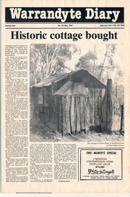
Report and photograph about purchase of historically significant slab cottage in Castle Road, Warrandyte. Newspaper also includes articles relating to Jock Macneish and his ultra-light aircraft, construction of foot bridge over Andersons Creek, Mrs Ruth Norman, Warrandyte Co-op, local results of the 1981 census, construction of elderly citizens' flats in Stiggant Street (Warrandyte), South Warrandyte Primary School, Professor's Hill and Warrandyte Football Club. The road guide features advertisments for Inglenook Tea Rooms, Warrandyte, Warrandyte Recreation Reserve Cafe (Mrs C. Miller, Proprietress), Eltham Motor Garage, Plaza Cafe Eltham, Eltham Park Team Rooms, Diamond Creek Garage and Engineering Works and The Dean Guesthouse Strathewen.Complete issue of "Warrandyte Diary" No 145, May 1984 with feature article headed "Historic cottage bought". 12 pages with section cut out of back page. Also includes photocopy of Broadbents Roadguide: central Victoria, 1946 pages 230-231HG Booklet 281981 census, advertisment, andersons creek, castle road, diamond creek garage and engineering works, eltham motor garage, eltham park team rooms, footbridge, harry gilham collection, inglenook tea rooms, jock macneish, mrs c. miller, mrs ruth norman, plaza cafe eltham, professor's hill, senior citizens, south warrandyte primary school, stiggant street, the dean guesthouse strathewen, warrandyte, warrandyte co-op, warrandyte football club, warrandyte recreation reserve cafe, warrandyte slab cottage -
 Eltham District Historical Society Inc
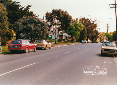
Photograph, Looking west near 942 Main Road, Hurstbridge, c. Oct 1987, 1987
Yvonne's Dressmaking and Alteration Service at 942 Main Road. Formerly a bakery, the building was demolished in 1990 and is now the site of Hurstbridge Saddlery. The milkbar is down the road, brick wall with a blue sign on it. There's still an older house next to the milkbar, but that's hidden from view in this shot as it's further back from the road. Date based on other similar display panels visible in images of the Shire of Eltham display at the Eltham Community Festival, 7 November 1987. Shire of Eltham Engineering Department Providing the resources to undertake • Survey, design, consultation • Road construction and maintenance • Bridge construction and maintenance • Street sweeping • Drain and pit cleaning • Traffic engineering installation and maintenance • Garbage collection • Tip management, land reclamation and beautification • Maintenance of community buildings • Provision of community and recreation facilitiesPhoto print mounted on carddisplay panel, eltham festival, heidelberg-kinglake road, hurstbridge, hurstbridge milk bar, infrastructure, main road, mm, shire of eltham, yvonne's dressmaking and alteration service -
 Kiewa Valley Historical Society
Postcard Circa 1950, Mt. Beauty Village, Kiewa Hydro-Electricity Project, circa 1950
This postcard was produced in the 1950's for the tourist trade in the Kiewa Valley and Alpine region. It encompasses the period when the State of Victoria was pressured by the ever increasing demand by industry and its population for electricity supplies. Hydro electricity was seen as an untapped natural resource to quench this demand. The Victorian Alps and the rivers flowing into its valleys was ideal for the construction of the Kiewa Hydro Electricity Scheme. The late 1940's saw the development of this scheme and the changing of sections of alpine landscape is covered by this and other postcards/pictures (tourists, construction workers, and established rural populations). This period in time was before the established wildlife and forest/nature groups became political activist who changed legislative acts to protect the environment. The regulatory pondage on the northern aspect of the village had no water over-spill from the unfinished power station.This rural region in 1950 (Kiewa Valley/alpine plains) was at most only significant to a smaller group of winter sports, summer hikers/horse riders and rural farmers/graziers. The numbers of tourists and the increase in the local resident population was boosted by the construction of the Hydro Electricity Scheme. This influx to the regional population resulted in a corresponding diversity in services and brought about an environment that responded to a growing level of tourists and thereby permitting this industry to grow more rapidly than it would have naturally. This postcard details an attraction to the "cleaner" method of providing electricity. This postcard was purchased in 1950 by a surveyor at Landford's Gap. The couple shown in this photograph would have been employed by the S.E.C. under the Kiewa Hydro-Electricity Scheme.This item is a scanned black and white photograph of a panoramic view of Mount Beauty Village in 1950 (a closed village, entry by pass only). The regulatory pondage has earthen walls but no water.See 0480 (A) -(D) and (F) for other photos of similar postcards"MT. BEAUTY VILLAGE KIEWA HYDRO-ELECTRIC PROJECT"kiewa valley tourism, victorian alps, alternate energy supplies, alpine population growth