Showing 22198 items
matching parks
-
 Greensborough Historical Society
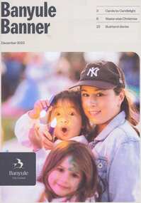
Magazine, Banyule Banner December 2023, 2023_12
The Banyule Banner is published by Banyule Council to advertise upcoming events in the City of Banyule and to report on past events. This edition contains reports on Carols by Candlelight, a waste wise Christmas, Ivanhoe Park Croquet Club, council services and community events.A record of events within the City of Banyule.24 pages, colour illustrations. banyule banner, banyule council -
 Greensborough Historical Society
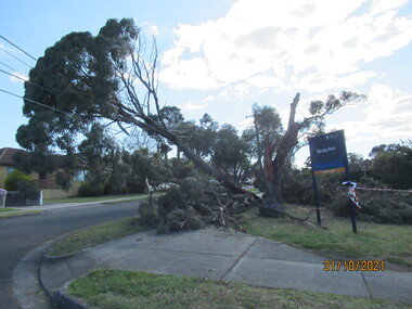
Photograph - Photograph - Digital Image, Peter Simmenauer, Storm damage, Barclay Park 2021, 27/10/2021
Storm damage incurred on night of 27-28/10/2021 at Barclay Park, cnr. Mackenzie Street & Plenty Lane, Greensborough. SES have lopped some of the dangerous tree limbs, but some are still resting on electric and communication wiring. Colour digital photographDate stamped: 31/10/2021barclay park, mackenzie street greensborough, plenty lane greensborough, storm damage -
 Greensborough Historical Society
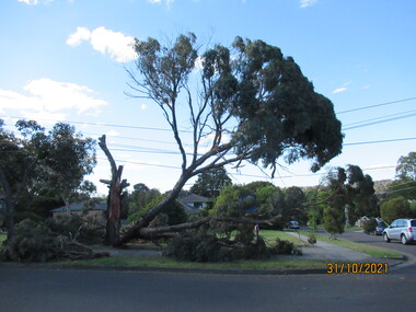
Photograph - Photograph - Digital Image, Peter Simmenauer, Storm damage, Barclay Park 2021, 27/10/2021
Storm damage incurred on night of 27-28/10/2021 at Barclay Park, cnr. Mackenzie Street & Plenty Lane, Greensborough. SES have lopped some of the dangerous tree limbs, but some are still resting on electric and communication wiring. Colour digital photographDate stamped: 31/10/2021barclay park, mackenzie street greensborough, plenty lane greensborough, storm damage -
 Greensborough Historical Society
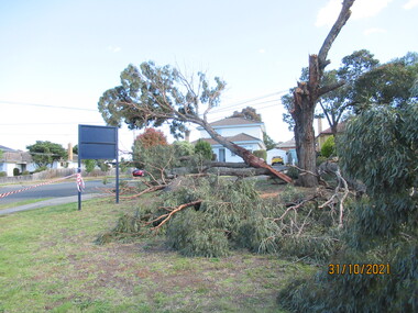
Photograph - Photograph - Digital Image, Peter Simmenauer, Storm damage, Barclay Park 2021, 27/10/2021
Storm damage incurred on night of 27-28/10/2021 at Barclay Park, cnr. Mackenzie Street & Plenty Lane, Greensborough. SES have lopped some of the dangerous tree limbs, but some are still resting on electric and communication wiring. Colour digital photographDate stamped: 31/10/2021barclay park, mackenzie street greensborough, plenty lane greensborough, storm damage -
 Greensborough Historical Society
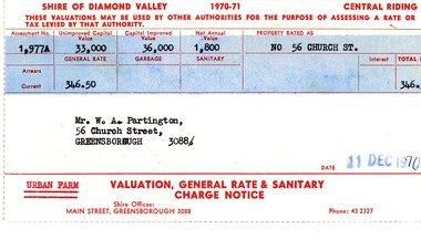
Financial record - Account, Shire of Diamond Valley, Shire of Diamond Valley rates notices 1970-1971, 26/03/1958
Shire of Diamond Valley Rates assessment issued to Alan Partington in 1970. This land is assessed as an "Urban Farm". In 1974 the 'farm rate' was declined for this property, eventually leading to its acquisition by the Shire for recreational space, now known as Whatmough Park.Part of the property owned by the Partington family in the original Greensborough farmland. Rates notice, printed in red text with black typed details.Date stamped with rubber stampalan partington, william alan partington, partington family, land deals greensborough, church street greensborough, whatmough park -
 Greensborough Historical Society
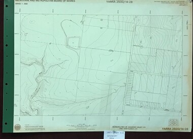
Map, Melbourne and Metropolitan Board of Works. Survey Division, MMBW, Yarra 2500 / 14.28. Yarrambat Park, 1977_09
Melbourne and Metropolitan Board of Works. Yarra 2500 [base map] 14.28. Yarrambat Park. Municipalities of Diamond Valley 257 and Whittlesea 239. Prominent streets include: Bannons Road and Yan Yean Road. Features include the Plenty River.MMBW Map in 1:2500 [scale] series. Cream parchment with green tape reinforcing on edges and punched holes on left edge.mmbw, melbourne and metropolitan board of works, shire of diamond valley, whttlesea, yarrambat - maps -
 Greensborough Historical Society
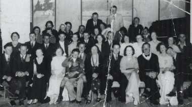
Photograph - Digital image, Lower Plenty Hall Group, 1940c
A large group of people at a function at Lower Plenty Hall. The Hall has now been demolished to make way for a car park. Photographs from the collection of Peter Blackbourn, a descendant of the Chapman Stock family. Annotations to photos by Peter Blackbourn.Digital copy of black and white photograph.peter blackbourn, lower plenty hall -
 Greensborough Historical Society
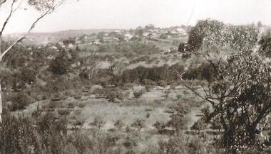
Photograph - Digital Image, Partingtons Flat and Whatmough Park taken from hill, 1930c
The Partington and Whatmough families came to Melbourne in the 1840s and moved to Greensborough where they farmed along the Plenty River. The Partingtons Flat Reserve and Whatmough Park were part of their land holdings and are now Banyule Council owned reserves and sporting fields.Digital copy of black and white photograph.partington family, whatmough family, whatmough park, partingtons flat -
 Eltham District Historical Society Inc
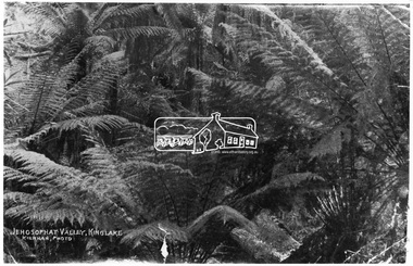
Photograph, Kinglake National Park; view from the Mountain Trail
Kinglake National Park was established in 1928 on 11,300 acres in the Shire of Eltham. Jehosophat Valley was named by the Hotelier Frank Thomson's father, who was so struck with the grandeur of the valley in all its pristine beauty that he 'ejaculated the word Jehosophat.'This photo forms part of a collection of photographs gathered by the Shire of Eltham for their centenary project book,"Pioneers and Painters: 100 years of the Shire of Eltham" by Alan Marshall (1971). The collection of over 500 images is held in partnership between Eltham District Historical Society and Yarra Plenty Regional Library (Eltham Library) and is now formally known as 'The Shire of Eltham Pioneers Photograph Collection.' It is significant in being the first community sourced collection representing the places and people of the Shire's first one hundred years.Digital imagesepp, shire of eltham pioneers photograph collection, kinglake, kinglake national park, view, bush, ferns, jehosophat -
 Eltham District Historical Society Inc
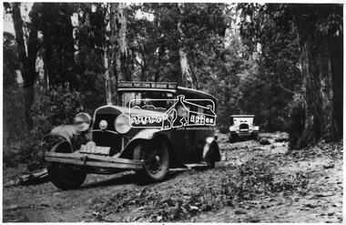
Photograph, Goodwood Powelltown Melbourne Daily
Two cars, probably 1929 Chryslers navigate the forest track probably Kinglake National Park. Front vehicle has sign: "Goodwood Powelltown Melbourne daily". Photo sourced from the Forests Commission of Victoria. Ref. JJ 399This photo forms part of a collection of photographs gathered by the Shire of Eltham for their centenary project book,"Pioneers and Painters: 100 years of the Shire of Eltham" by Alan Marshall (1971). The collection of over 500 images is held in partnership between Eltham District Historical Society and Yarra Plenty Regional Library (Eltham Library) and is now formally known as the 'The Shire of Eltham Pioneers Photograph Collection.' It is significant in being the first community sourced collection representing the places and people of the Shire's first one hundred years.Digital imagesepp, shire of eltham pioneers photograph collection, kinglake, goodwood powelltown melbourne daily, automobile, chrysler, kinglake national park, forest track -
 Port Melbourne Historical & Preservation Society
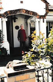
Photograph - 51 Esplanade West Port Melbourne, Janet BOLITHO, c.2006
House built in the inter-war period. Council approved a four 3 storey development with 8 on-site car parks in 2008. It was appealed to VCAT but unsuccessfully and the house was demolished in December 2010. Fire destroyed much of the building prior to ademolition.Colour photograph of Ron in porch at 51 Esplande West, Port Melbourne.built environment - domestic, built environment - demolition, esplanade west -
 Lake Bolac & District Historical Society
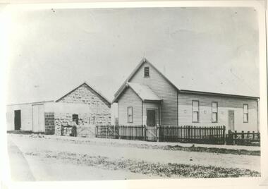
black and white photograph, Lake Bolac Hall 1896
Photograph of the first Lake Bolac Hall built in 1896. It was located in Montgomery Street between the Hotel and Park's Blacksmith Shop. It was later re-located across the street to form the supper room of the Lake Bolac Memorial Hall built in 1922.black and white photographlake bolac, hall, supper room, memorial -
 Clunes Museum
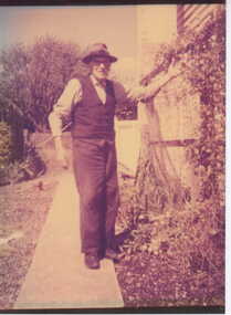
Photograph
RICHARD FORD WAS A LOCAL ARTIST, WHO PAINTED THE STAGE BACK DROP AND THE WORLD WAR 1 MEMORIAL IN THE CLUNES TOWN HALL. HE WAS A COUNCIL FOREMAN, HORTICULTURALIST AND PARK CURATOR, AND LATER TAUGHT WOODWORK AT THE CLUNES HIGHER ELEMENTARY SCHOOL.PHOTOGRAPH OF RICHARD FORD IN HIS GARDEN IN SMITH STREET, CLUNESlocal history, photography, photographs, ford, richard -
 Stawell Historical Society Inc
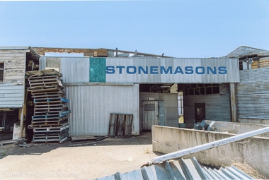
Photograph, Carol Ann Jones, Stonemasons on the corner of Main and Napier Streets, next to Central Park Stawell -- 6 Photos -- Coloured
4 Colour photographs showing stonemasons buildings in Lower Main street on corner of Napier Street Stawell. On corner of Central Park prior to demolition One photo shows headstones and pallets. Business established in 1864. Demolished March 2018. -
 Sunbury Family History and Heritage Society Inc.
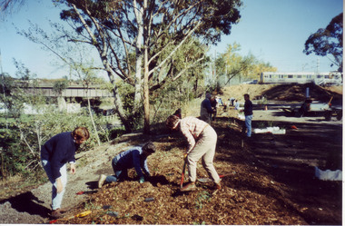
Photograph, Tree planting
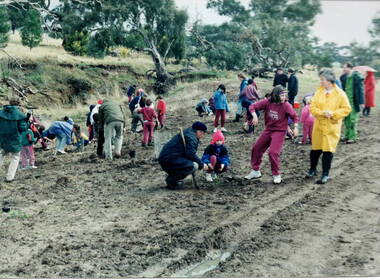
The students from Bulla Primary School were taken on a school excursion to nearby Woodlands Park where they took part in a tree planting activity. They were planting trees that were native to the area in a bid to replenish the parkland with natural vegetation.The excursion aimed to give the students an awareness of the native vegetation in the area and the importance of conserving natural growth areas. A non-digital photograph of a group of children planting young trees in a prepared area in parkland while being supervised by a number of adults tree planting, woodlands park, bulla primary school, native vegetation -
 Sunbury Family History and Heritage Society Inc.
Photograph, Gellibrand Hill
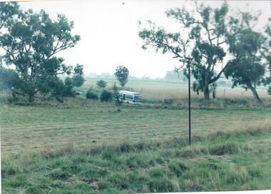
After a day at Gellibrand Hill where the students from Bulla Primary School were engaged in tree-planting and being shown around the park, they were driven back to school in their small school bus in a very sudden rain storm.A non-digital photograph of a small bus driving out of a natural parkland.gellibrand hill, school excursions, bulla primary school -
 Stawell Historical Society Inc
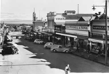
Photograph, Main Street Stawell looking West 1950's
B/W Main Street looking West. Taken from Bull and Mouth Hotel verandah. Vehicles angle parked in street. Town Hall clock tower Coles. George Mitchell & Sons and Norman A Harding on right. 1950'sstawell businesses streetscape -
 Stawell Historical Society Inc
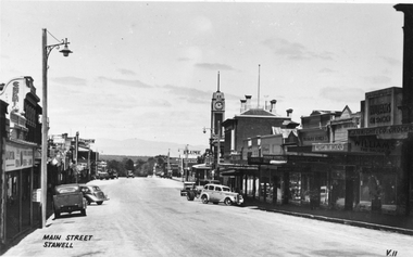
Photograph, Main Street Stawell looking West c1940's
B/W Main Street looking West. Taken from in front of Dane Bros Spirits Bull and Mouth Hotel verandah. Vehicles angle parked in street. Town Hall clock tower Post Office visible. 1940'sstawell businesses -
 Lakes Entrance Regional Historical Society (operating as Lakes Entrance History Centre & Museum)
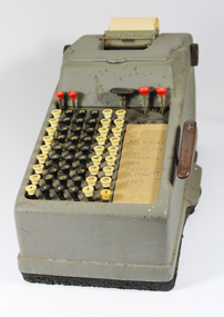
Machine - Adding machine, 1955 c
Includes power cable and paper docket roll, converted from Imperial to Decimal in 1969, bought from Australian Paper Mills 1955c by donor, used in Lakes Entrance Caravan Park and Traralgon during 1960's and 1970'sElectric Adding machine, grey case sits on black rubble pad, 9 rows of 6 keyscommerce, office equipment, stationery -
 Stawell Historical Society Inc
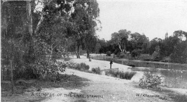
Photograph, Botanical Reserve in Stawell West
Botanical Reserve Stawell West with a gentleman and boat. The first committee of management was gazette in 1863. In April 1870 the reserve was placed under the control of the Borough Council. The Botanical Reserve Stawell West is now called The Grampian Gate Caravan Park.Black and white photograph of a scene of trees lining a lake. A person is fishing on the bank with a small boat nearby.A glimpse of the lake, Stawell. W.J. Chapman photo. The post card is dated Sept. 8th 1915 to Dear Les and from Jane & Frank, Les's brother and sister.stawell -
 Bendigo Historical Society Inc.
Map - HUSTLER'S ROYAL RESERVE NO 2 MINE - PLAN OF THE HUSTLER'S ROYAL RESERVE NO 2 MINE
Plan of the Hustler's Royal Reserve No 2 Mine Bulletin No 33, Plate No V. Plan shows the Hustler's Royal Reserve No 2 (Main Shaft), Hustler's Royal Reserve No 2 (Park Shaft.), the Royal Hustler's, the Imperial Hustler's and the Extended Hustler's Freehold on the Hustler's Line of Reefs. Also mentioned is the Lightning Hill Line of Reefs. Map shows some of the levels, approximate boundary of lease and the boundary of Lease No 8892 and 8897. There are also street names and the locations of jail, lagoons, Post Office, Rosalind Park and the State School, High School and Continuation School. Geological Survey of Victoria emblem. H. Herman Director, W. Dickson, Secretary of Mines and The Hon. J. Drysdale Brown MLC, Minister of Mines. Signed by zh Whitdan, Underground Survey Office, Bendigo, September 1913.mining, parish map, hustler's royal reserve no 2 mine, plan of the hustler's royal reserve no 2 mine, hustler's royal reserve no 2 (main shaft), hustler's royal reserve no 2 (park shaft), royal hustler's, imperial hustler's, extended hustler's freehold, geological survey of victoria, h herman, w dickson, the hon j drysdale brown, h whitdan, hustler's line of reefs, lightning hill line of reefs -
 Ballarat Heritage Services
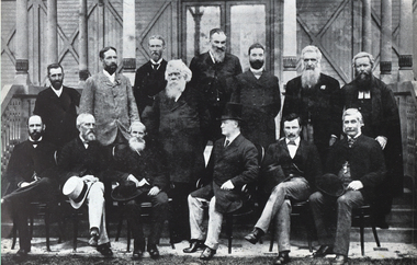
Photograph - Image, Members of the Australasian Federation Convention
This group of men are considered fathers of Australian Federation. Sixteen men of the members of the Australasian Federation Convention, 1890. The bearded man standing in the centre is Henry Parkes. Hon. Andrew Inglis Clark (Tasmania), Hon. Sir Samuel Walker Griffith KCMG (Queensland), Hon. Thomas Playford (Sth. Aust.), Hon. Alfred Deakin (Victoria), Hon. Bolton Stafford Bird (Tas.), George H. Jenkins (Secretary to the Conference), Hon. Capt. William Russell Russell (New Zealand), Hon. Sir Henry Parkes (New South Wales), Hon. William McMillan (N.S.W.), Hon. Sir John Hall KCMG (N.Z.), Hon. John Murtagh Macrossan (Qld), Hon. Duncan Gillies (Vic.), Hon. John Alexander Cockburn M.D.(Sth.Aust.), Hon. Sir James George Lee Steere (Western Australia).national conventon, henry parkes, federation, duncan gillies -
 Melbourne Tram Museum
Document - Timetable - MMTB bus routes 1962 and 1963, Melbourne & Metropolitan Tramways Board (MMTB)
Produced by the MMTB to provide timetable information on Melbourne bus routes to passengers. Shows the extension of the Clifton Hill to Elsternwick route to Point Ormond after the closure of tram service to Point Ormond and for services that replaced the Footscray tram lines.Shows the method of production of timetables in the early 1960s.Set of 7 bus timetables, duplicated sheets as noted below - printed on foolscap sheets. .1 - Sunshine Park - City - 15/3/1963 - single sheet .2 - Sunshine (via South and Dynon Roads) - City Bus - 20/7/1962 - single sheet .3 -Garden City - City - undated - single sheet .4 - Queens Bridge - Fisherman's Bend, - via various routes - June 1963, four sheets stapled in top left hand corner. .5 - Deer Park - City - 14/11/1962 .6 - Clifton Hill - Point Ormond - Esternwick - undated .7 - Ballarat Road - Footscray Station - Williamstown Rd - Russell St - 15/6/1962 - three sheets stapled in top left hand corner.timetables, buses, mmtb, footscray, sunshine, fisherman's bend, clifton hill, point ormond, garden city, bus replacement -
 University of Melbourne, Burnley Campus Archives
Album - Digitised, Sandra Pullman, Sandi Pullman Album, 1998-2000
93 photographs from Sandi Pullman's album. Scanned March 2013. Some have descriptions on reverse. Originals remain with Sandi Pullman (Student, FOBG). (13-19) John Delpratt's Grassland Project FOBG 30.05.98. (20-30) FOBG Working Bee 10.10.98 Ground Cover Trial Plots. (1-12) First Friends of Burnley Gardens Working Bee, "Planting the Back Car Park along the trainline 2nd May, 1998. (First Stage of the car park sited on Richmond City Council land at the rear of the College completed 1980.) (31-45) Back Car Park 11.09.99. (46-51) Native Garden 27.11.99. (52-53,72-75) 150th Celebration of What? Oct 2000, Ellis Stones Rockery Oct 2000. (54-58, 71, 76, 84, 86, 88-91, 93) Harvesting Grasses. (59-62) Nicki Rose from the Australian Plant Society presenting Dr Greg Moore with $1,500 cheque at an afternoon tea on the Citriodora Lawn 31.03.2000. (63-70) Melbourne International Flower & Garden Show (M.I.F.G.S.) 2000. (77-83) First Pruning Day 1999.sandi pullman, sandra pullman, fobg, john delpratt's grassland, working bee, native garden, ellis stones rockery, harvesting grasses, nicki rose, australian plant society, dr greg moore, melbourne international flower & garden show, m.i.f.g.s., back car park, wrong 150th celebrations, ground cover trials -
 Melbourne Tram Museum
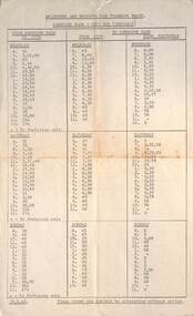
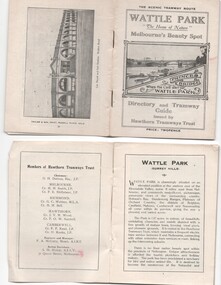
Ephemera - Timetable, Hawthorn Tramways Trust (HTT), "Directory and Tramway Guide issued by the Hawthorn Tramways Trust", 1918
Booklet - 38 pages, printed on off white page, centre stapled, titled "Directory and Tramway Guide issued by the Hawthorn Tramways Trust", specifically advertising Wattle Park and showing Princes Bridge and the Yarra on the front cover and a photo of Hawthorn depot on the rear cover. Gives details of Wattle Park, its opening, many photos, members of the Trust, Engineer and Manager and Acting Secretary, Stopping points for the round and fares to Wattle Park, section fares, maps of the tram routes and connections with other tramways and railway stations. Has timetables for Burnley and other major points, special and emergency services, the coloured lights used on the trams, and a map for land sales at Riversdale Heights estate. Advertisements for Mutual stores, Melbourne Electric Supply Co., Moule, Hamilton and Kindle for the sale of land at Riversdale Heights and a map showing the estate location. Both copies have alterations or corrections to the route signage letters - marked in red - from the Minutes of the HTT Board meetings, the Trust were not happy with the finished product and was reluctant to pay for them - see Minutes of Meeting No. 99 of 5-7-1918. Two copies held - one with red marks on the front cover.trams, tramways, htt, wattle park, princes bridge, hawthorn depot, timetables, mesco, real estate -
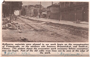 Melbourne Tram Museum
Newspaper, Royal Automobile club of Victoria (RACv), removal of the cable tram track in Victoria Parade, 1963 to 1971
Set of 8 newspaper clippings, mid 1960's concerning traffic control and congestion issues. .1 - Royal auto - 2/1963 - reporting on the removal of the cable tram track in Victoria Parade between Brunswick and Smith St, noting the old cable tram lines. .2 - Royal auto - 1/65 - Photo of Toorak Road Toorak with a tram and parked cars. .3 - Royal auto - 8/64 on Chapel St with W2 324 (route 77, City) showing the impact of parked cars at 8.45am and a motor car trying to squeeze past. .4 - Royal auto - 9/64, Burke Road Camberwell, showing the impact of parked cars and trams. Photo includes SW6 934 (Route 7 Camberwell) .5 - Royal auto - 8/67 - Swanston St near Collins St. .6 - View of Toorak Road, Hartwell, W2 641 (Spencer St, route 74) photo 8/68 by John Shingler. shows the shopping centre. .7 - Royal auto - 9/64 - Johnston St Collingwood and buses. .8 - MMBW Living City Winter 1971 of Kew Junction, peak hour inbound noting the new Eastern Freeway will reduce congestion.Extensive notes on the rear of the photo, see image i2trams, tramways, congestion, traffic control, racv, chapel st, toorak road, victoria parade, cable trams, w2 class, sw6 class, burke road, camberwell, route 77, route 7, swanston st, kew junction, route 74, hartwell, johnston st, buses, tram 324, tram 641, tram 934 -
Glen Eira Historical Society
Article - Ormond Baseball Club
... Parks ...This file contains seven items. A stencilled letter from the Ormond Baseball club addressed to a member extending an invitation to a Reunion Smoke Night at the pavilion at Ormond Park, dated 28/07/2961 An article from the Caulfield/Port Phillip Leader on the division two standings where Ormond Glenhuntly Baseball Club was ranked twelve out of fourteen teams, 21/12/2010 An article from the Caulfield/Port Phillip Leader stating that Ormond Glenhuntly Baseball Club are one of three teams who are battling not to finish in last place, dated 11/01/2011 An article from the Caulfield/Port Phillip Leader in which Ormond Glenhuntly Baseball Club are ranked thirteen out of fourteen teams on the ladder, dated 11/01/2011 An article from the Caulfield/Port Phillip Leader in which Ormond Glenhuntly Baseball Club are said to be performing poorly, dated 15/02/2011 An article from the Caulfield/Port Phillip Leader in which Ormond Glenhuntly Baseball Club are ranked twelve out of fourteen teams on the ladder, dated 06/03/2012 A two-page extract from the pamphlet Community Snapshot produced by the Bendigo Bank on the records set by Ormond Glenhuntly Baseball Club in the 2012-13 season, dated May 2013ormond baseball club, baseball clubs, ormond, clubs, associations, sports, recreations, competitions, sporting clubs, leisure, cultural events, cultural associations, sports grounds, ovals, ormond glenhuntly baseball club, parks, reserves, sports people, summer league, armstrong ian, entertainment, oakleigh crescent, glenhuntly, caulfield/port phillip leader, bendigo bank, ogbc, hoenig jeff, ormond-mckinnon community bank, glen eira council, ee gunn reserve, lygris manny -
 Federation University Historical Collection
Letter, Associated Board of Royal Schools of Music correspondence, 1936, 26th March, 1936
Frank Wright was a renown resident of Smeaton, where he was born on 2 August 1901. He lived at Laura Villa, and attended Smeaton State School. His father William was a gold miner and his mother's name was Sarah. Their family won many singing and instrumental awards. Frank was tutored by Percy Code and was awarded a gold medal for the highest marks in the ALCM examinations in the British Colonies at the age of seventeen years. He became the Australian Open Cornet Champion by the age of eighteen. A year later, Frank conducted the City of Ballarat Band, and later the Ballarat Soldiers’ Memorial Band. He formed the Frank Wright Frisco Band and Frank Wright and his Coliseum Orchestra. These bands won many South Street awards, and Frank as conductor won many awards in the Australian Band Championship contest. In 1933 Frank Wright sailed to England to conduct the famous St Hilda’s Band and was later appointed Musical Director of the London County Council, where he organized many amazing concerts in parks, in and around the London district. He was made Professor of Brass and Military Band Scoring and conducted at the Guildhall of Music and Drama. Frank was often invited to adjudicate Brass Band Championships around Europe, in Australia, including South Street and in New Zealand. The Frank Wright Medal at the Royal South Street competition is awarded to an individual recognized as making an outstanding contribution to brass music in Australia.An addressed envelope which is addressed to Frank Wright and a sheet of paper which is a letter from The Associated Board of the Royal Schools of Music.On the top left hand corner of the envelope is "The Associated Board of The Royal Schools of Music, London (The Royal Academy of Music and Royal College of Music) 14 & 15, Bedford Square. London, W.C.I on the right hand side is an inked stamp in red with Great Britain a crown G v R Post Paid N 1/12d 99. The address is Frank Wright Esq LRSM. 226 Cambridge Street, Hyde Park W2 The letter is from the Associated Board of the Royal Schools of Music London, altering Frank Wright that he is entitled to describe himself as a Licentiate of The Royal Schools of Music, London (L.R.S.M., London)frank wright, royal school of music, l.r.s.m. -
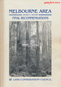 Eltham District Historical Society Inc
Book, Land Conservation Council, Melbourne Area, District 2 Review: Final Recommendations, 1994
Notices showing the boundary of the area of the review and advising that an investigation was to be carried out were published in the Victoria Government Gazette and in local and other Victorian newspapers in May 1987. A descriptive resources report was published in August 1991. Council received 1,425 submissions and letters following publication of the descriptive report. The Council considered these submissions and published proposed recommendations in April 1993. A further 1,993 submissions were received in response to the proposed recommendations. The Council published its final recommendations in July 1994. A change to legislation in 1989 enabled the LCC to make recommendations for public land within a ‘town’, though cities and rural cities remained excluded from the definition of public land. Timber resources and water quality and yield from timbered catchment areas remained significant issues in Melbourne’s catchments. Recommendations for the Yarra Ranges National Park were based around the closed Melbourne water catchments and adjoining state forest. A recommended Phillip Island State Park based around the penguin reserve was ultimately implemented as the Phillip Island Nature Park.Shire of Nillumbik DPE/Enviro -
 Eltham District Historical Society Inc
Document - Series Listing, Fraser Faithfull et al, Series 52: Ari in Public Places Awards 1992 & 1994, photographs, 2000
Series consists of one folder of photographs relating to Art in Public Places awards. The folder is divided into two parts: I) Presentation and Installation - 1992 Award. Colour prints featuring Shire President Pamela Sladden opening "The Tower" at Weir St Park, Montmorency. Also pictured are Shire Arts officers Caroline Shaw and Chris Marks. Folder includes: * B& W and colour photographs taken on the night of the award presentation. * Four colour photographs of Weir St Park prior to installation of tower. * Colour photographs of two alternative sites for installation of tower. 2) Selection of 18 colour photographs taken at Selection Night for the 1994 Art in Public Places award. This event took place in the new Eltham Library. Also included arc panels of32 photographs (colour and B&W) of Alistair Knox Park and the immediate area around the new Eltham Library - photocopies of these pictures were provided to artists to give them a feel for the area. Note that selection took place after the commencement of the Nillumbik Shire Council, possibly in 1995.shire of eltham archives, series listing