Showing 22198 items
matching parks
-
 Eltham District Historical Society Inc
Photograph - Aerial Photograph, Landata, Eltham, Vic, Apr. 1963
Centred on present day Floriston Grove, Eltham bounded by Maroondah Aqueduct to north, Thompson Crescent and Diosma Road to south, Research Shops to east and Glen Park Road and Park West Road to west. Historic Aerial Imagery Source: Landata.vic.gov.au Aerial Photo Details: Project No :486 Project : MELBOURNE (1963) PROJECT Run : 5 Frame : 60 Date : 04/1963 Film Type : B/W Camera : RC8 Flying Height : 5100 Scale : 9600 Film Number : 1805 GDA2020 : 37°42'24"S, 145°09'29"E MGA2020 : 337622, 5825128 (55) Melways : 22 B3 (ed. 42)aerial photo, neil webster collection, eltham, 1963-04, diosma road, floriston grove, maroondah aqueduct, melway 22b3, park west road, research (vic.), research shops -
 Eltham District Historical Society Inc
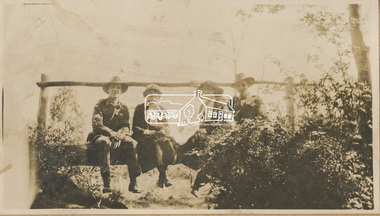
Photograph, "Resting, Eltham", 22 Oct 1919
This photo depicts an outing of VAD nurses Alice Broadhurst, McGeachy and Byrne and two patients of No. 16 AGH Macleod (Mont Park Military Hospital), Curry and Caffery to Eltham in spring 1919. Broadhurst's companions pose sitting on a log bridge. This photo is part of the Alice Broadhurst collection held by Yarra Plenty Regional Library, a series of 12 photo albums compiled by Alice Broadhurst (1896-1981), initially while working as a Voluntary Aid Detachment nurse with the Australian Red Cross at the Mont Park Military Hospital (No. 16 AGH) and subsequently as a nurse at the Royal Melbourne and Royal Women’s hospitals alongside many pioneering doctors of their fields.Digital fileeltham, alice elizabeth broadhurst, byrne, caffery, curry, mcgeachy, nursing staff, mont park, 16 agh, log bridge -
 Eltham District Historical Society Inc
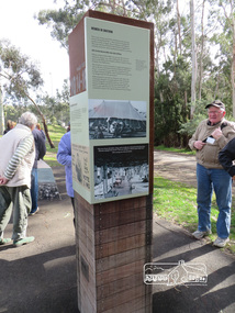
Photograph, Shire of Nillumbik World War One Memorials tour, 10 August 2016, 10 August 2016
As part of a program to acknowledge the Anzac Centenary Nillumbik Shire Council partnered with Yarra Plenty Regional Library to provide a bus tour with commentary of local sites of significance. These included Eltham township, the Shire of Eltham War Memorial at Kangaroo Ground, Christmas Hills, Hurstbridge memorial recreation park and finished at Eltham Library to view the Writing the War exhibtion at Eltham Library Community Gallery. In June 2014 Nillumbik Shire Council received Anzac centenary Local Grants Program funding to create new interpretative signage that acknowledged the history of the Hurstbridge Memorial Recreation Park as a memorial to all who served in the First World War. One of the panels discusses women. Born Digitalworld war 1, war memorials, hurstbridge, interpretation panel, interperative signage -
 Eltham District Historical Society Inc
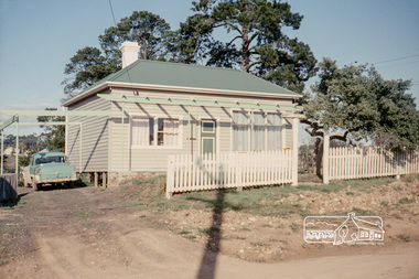
Photograph, Russell Yeoman, 66 Susan Street, Eltham, 1965c
Farmhouse built in the late 1800s by the Crozier Family. Subsequently owned by the Hill Family. Purchased in the early 1960s and by 1965 the property was owned by the Shire of Eltham. Employees of the Shire lived in the house. In 2006 the Shire of Nillumbik demolished the house which had been subject to extensive vandalism. In accordance with heritage advicde and a permit condition a sign was placed on the site outlining the history of the building. This was installed and remained in place till about 2016 when it was removed. The lands adjoins Alistair Knox Park. By 2010 the Eltham Skate Park was developed. In 2022 a major renovation and extension took place. Sources: EDHS Newsletter No 171 November 2006 and Google Street View. Digital file only; created from original colour positive slide transparencyeltham, streets, houses, susan street, alistair knox park, eltham skate park, russell yeoman collection, fc holden sedan -
 Cheese World Museum
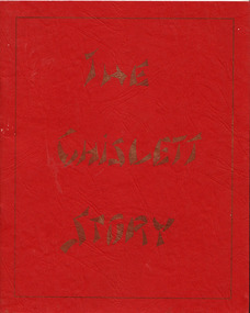
Book, The Chislett Story, 1982
The Percy Uebergang family lived at Tooram Park, Allansford from 1912 until 1992. Percy and Myrtle Uebergang's children were twins, Ray and Joyce born in 1926 who lived at Tooram Park until their deaths, Ray in 1986 and Joyce in 1992. Neither Ray nor Joyce married and following the death of her brother Joyce set up the Ray and Joyce Uebergang Foundation which supports the local community. This book is part of the collection of items given into the care of the Cheese World Museum. The Chislett family were early district settlers. The book was compiled for the family reunion held at Allansford on 7 March 1982. Wendy Boyle wrote the preface.Red cardboard covered book with title in gold print within a fine gold border detailing the history of the Chislett family.Family History of George and Hope Chislett and their descendants. 288 [written inside front cover]allansford, uebergang, chislett, george, chislett, hope, boyle, wendy, local history -
 Cheese World Museum
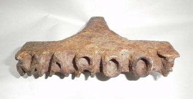
Stamp, Metal stamp 'Tooram'
The Percy Uebergang family lived at Tooram Park, Allansford from 1912 until 1992. Percy and Myrtle Uebergang's children were twins, Ray and Joyce born in 1926 who lived at Tooram Park until their deaths, Ray in 1986 and Joyce in 1992. Neither Ray nor Joyce married and following the death of her brother Joyce set up the Ray and Joyce Uebergang Foundation which supports the local community. This metal stamp is part of the collection of items given into the care of the Cheese World Museum. The stamp would have been used to brand cattle by heating it and placing it against the skin to burn the brand into the animal's hide. Cast metal wedge-shaped stamp with 'Tooram' in reversed raised lettering. The wooden handle is missing.MAROOTuebergang, allansford, tooram -
 Ballarat Tramway Museum
Photograph - Geelong 17 - Moorabool St, early 1930s
The photo taken at the corner of Moorabool and Malop Streets, is looking south along Moorabool St. Shows Geelong tram 17 tram about to turn "wrong line" from Moorabool St into Malop St. The tram has the destination of West. Why it is turning at this location is unknown. In the background is another tram running south along Moorabool St along with other trams at the intersection with Ryrie St. The photo shows four buses parked on both streets. In the background are the Solomons store, and the National Bank of Australasia buildings. Has many parked cars. The photo is pre 1934, before the construction of the T&G building at the corner of Moorabool and Ryrie Sts.Yields information about Geelong late 1930s and tramway operations.Black and white photograph - plain back.geelong, tram 17, moorabool st, malop st, tramways -
 Eltham District Historical Society Inc
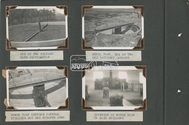
Album - Photograph Album, Alan Gardiner, M.M.B.W Braeside Sewage Treatment Plant Construction, 1939
In April 1928 the MMBW had the land and the plans for what they were to construct but the timing of the actual building did not proceed as planned. Before the construction could commence the Great Depression of the 1930s intervened forcing the shelving of its plans. The new owners then offered the land for lease resulting in Frederick Werrett taking the opportunity to take up the land he formerly owned to continue his market gardening activities of growing potatoes, onions and other crops. The land and improvements made by Syme were leased in 1929 to Harry Telford a trainer from New South Wales. Phar Lap grazed there for a short time. [9] However the population of Melbourne continued to grow and the need for a sewerage treatment plant did not go away. In 1939 when the effects of the Depression had dissipated work on the Sewerage Effluent Treatment Plant commenced and the following year in October the Premier of the State, Albert Dunstan, officially commissioned it. The Sewerage Effluent Treatment Plant at Braeside served the communities of south-east Melbourne for thirty five years until 1975. In that year all the sewers that entered the Braeside plant were diverted to the South Eastern Trunk Sewer complex at Carrum.[10] In 1982 the chairman of the MMBW at that time, Alan Croxford, announced that a substantial part of the property at Braeside would be administered by the Parks and Gardens section of MMBW as a public park. Subsequently the responsibilities were transferred to Parks Victoria, the situation that exists today. It is known as “Braeside Park” now. [Source: Sewerage Treatment Plant at Braeside, Kingston Local History, https://localhistory.kingston.vic.gov.au/articles/407]alan gardiner collection, 1939, braeside sewage treatment plant, construction, melbourne metropolitan board of works, mmbw -
 Eltham District Historical Society Inc
Album - Photograph Album, Alan Gardiner, M.M.B.W Braeside Sewage Treatment Plant Construction, 1939
In April 1928 the MMBW had the land and the plans for what they were to construct but the timing of the actual building did not proceed as planned. Before the construction could commence the Great Depression of the 1930s intervened forcing the shelving of its plans. The new owners then offered the land for lease resulting in Frederick Werrett taking the opportunity to take up the land he formerly owned to continue his market gardening activities of growing potatoes, onions and other crops. The land and improvements made by Syme were leased in 1929 to Harry Telford a trainer from New South Wales. Phar Lap grazed there for a short time. [9] However the population of Melbourne continued to grow and the need for a sewerage treatment plant did not go away. In 1939 when the effects of the Depression had dissipated work on the Sewerage Effluent Treatment Plant commenced and the following year in October the Premier of the State, Albert Dunstan, officially commissioned it. The Sewerage Effluent Treatment Plant at Braeside served the communities of south-east Melbourne for thirty five years until 1975. In that year all the sewers that entered the Braeside plant were diverted to the South Eastern Trunk Sewer complex at Carrum.[10] In 1982 the chairman of the MMBW at that time, Alan Croxford, announced that a substantial part of the property at Braeside would be administered by the Parks and Gardens section of MMBW as a public park. Subsequently the responsibilities were transferred to Parks Victoria, the situation that exists today. It is known as “Braeside Park” now. [Source: Sewerage Treatment Plant at Braeside, Kingston Local History, https://localhistory.kingston.vic.gov.au/articles/407]alan gardiner collection, 1939, braeside sewage treatment plant, construction, melbourne metropolitan board of works, mmbw -
 Ringwood and District Historical Society
Pamphlets, Maroondah / Ringwood: Various leaflets about local organisations and events, primarily Arts related. 2004-2008, 2004 - 2008
Various leaflets about local organisations and enterprises:; 1. Summer series 2007-2008;; 2. 2004 Maroondah - Winter Arts Festival;; 3. Parks and Paths Maroondah;; 4. Waterways of Maroondah;; 5. Maroondah Movement for Reconciliation Inc 2008; 6. Maroondah Art Gallert Program 2007; 7. Disabled Persons Craft and Display Fair 1981. -
 Phillip Island and District Historical Society Inc.
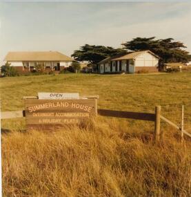
Photograph, John Cook, 1978-79
In 1927 Mr A. K. T. Sambell built a pier, planned and subdivided a residential estate, designed and built Summerland House, where ardent golfers after an enjoyable day on the course, could relax. Summerland House was built by local builder Mr Vic McRae. It attracted large numbers of professional people from Melbourne.Three photographs of Summerland Guesthouse, one of the first Guesthouses on the Island, situated above the site of the Penguin Parade. 81-87 Note sign: Open - overnight accommodation and holiday flats. 81-88 View of Summerland Guesthouse. Probably back view. Note elevated water tank. Car parked behind. 81-89 Another view of Summerland Guesthouse.coloured photograph, summerland guesthouse phillip island, akt sambell -
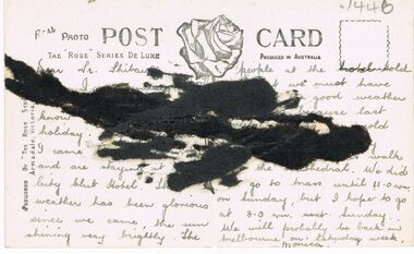
Glenelg Shire Council Cultural Collection
Postcard - Postcard - Hospital Portland , Victoria, n.d
Black and white photo postcard. View of old Portland hospital, taken from street (Bentinck or Fern). Buildings obscured by large trees, and high stone fence. Nurse standing either side of metal gate, with a 'PORTLAND HOSPITAL' sign on it. Woman in a two-seater roadster parked near gate. A man and 2 nurses can be seen in the groundsFront: 'THE PUBLIC HOSPITAL, PORTLAND VIC. TOYE, PHOTO' - white script on black bottom border Back: Purple stamp: 'TOYE BROS. Photographers, Hamilton & Portland' -
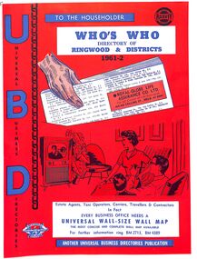 Ringwood and District Historical Society
Booklet, UBD Directory of Ringwood & Districts 1961-62
A Universal Business Directories Publication. Contains: Numerous advertisements by local business Summary of Ringwood services groups, wards, parks, schools, councillors, etc Doctor's Surgeries Index of streets Aerial maps Lists of businesses by business categories Includes the same for Croydon, Lilydale, Heathmont and Kilsyth. Some small business lists for Warrandyte, South Warrandyte, Vermont and Montrose. -
 Bendigo Historical Society Inc.
Photograph - LA TROBE UNIVERSITY BENDIGO COLLECTION BENDIGO: TEACHERS' COLLEGE BUILDINGS
A black and white photograph of an aerial view from the Lookout Tower in Rosalind Park of Bendigo Teachers' College as it was in the 1950's. In the foreground are aluminium prefabs and the old police stables. In the background is the old gaol and over to the left are the tennis courts which appear to have the sprinklers on. Although it is out of view Camp Hill Primary School is on the right of the buildings. 1950's.bendigo, education, bendigo teachers' college, la trobe university bendigo collection, collection, education, tertiary education, bendigo, bendigo teachers' college, place, buildings, bendigo gaol, tennis courts, gaol, photo, photograph, photographs, photography -
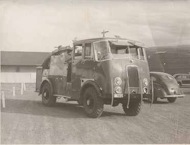 Bendigo Historical Society Inc.
Photograph - FIRE TENDERS
black and white photo. 3 motorised vehicles parked at large shed, one Nissan hut. Fire truck in front of the two sedan vehicles. Note number plate on fire truck, may be at aerodrome ? C 758 32 ' Foggit and Jones ( on rear ) in ink. Fire truck No. 4 with number plate C 75832. Note the Nissan hut in the background.organization, government, fire truck -
 Bendigo Historical Society Inc.
Photograph - FIRST SINKING, DERBYSHIRE MINE (FORMERLY WHIPSTICK GM CO.)
Black and white photograph, mounted on board, of First sinking of Derbyshire Mine, then Whipstick GM Co. Windlass over shaft. Woman in long dress to left of photo. Six men standing on top of excavated soil and rock - to right of windlass. Inscriptions: 'First sinking Derbyshire Mine then Whipstick GM Co', 'NW Harrison, Gladfield Park, Pyramid Hill.place, mining site, derbyshire mine -
 Bendigo Historical Society Inc.
Photograph - VIEWS OF BENDIGO
Photographs - 8 of (small) black & white. Photo's of Pall Mall (no.22), Civic Buildings (no.1), The Baths Upper Reserve (no.13), Alexandra Fountain (no.6), Conservatory Gardens (no.29), City Hall (no.8), Central Deborah Mine (no.19), Rosalind Park (no.5). Handed in by Barry & Vicki Mulvena of 48 Lord St.,m Roseville, NSW 2069.Valentine's Snapshots.place, bendigo, picturesque views of bendigo., views of bendigo. -
Bendigo Historical Society Inc.
Photograph - PHOTOGRAPH SANDHURST AND NORTHERN DISTRICT TRUSTEES
Copy of black and white photograph of Sandhurst trustees building with a horse and carriage parked at the front. Under the photo: publisher Crown Castleton, Bendigo. Sandhurst & Northern District Trustees & Agency, View Street Bendigo, circa 1900. Plate no 20 of a limited edition of 100 in a series of 25. Print no.42 Printer D. G. Walker, Pty Ltd, Bendigo.photograph, building, sandhurst trustees -
 Bendigo Historical Society Inc.
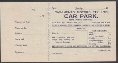
Document - CAMBRIDGE PRESS COLLECTION: RECEIPT - CASAMENTO MOTORS
Printed receipt for Casamento Motors Pty. Ltd. Car Park, View Point, Bendigo. Date line ends 193-. Receipt lists charges, Time in, Car Number and Attendant. The butt has No., date line, Number of Car, Name of car, Time in, Going out, Amount paid and signature. Printed on yellow paper with dark blue printing.business, printers, cambridge press, cambridge press collection, casamento motors pty ltd -
 Bendigo Historical Society Inc.
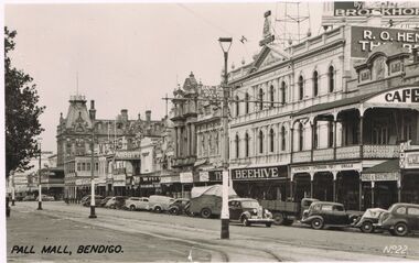
Postcard - PALL MALL, BENDIGO
black and white image: Pall Mall, looking northwards. Shopfronts visible from RH side: Hall & Batchelder, Favaloro's Cafe, The Beehive, Abbott, Myers, Shamrock Hotel. Cars parked at kerb, appear to be late 1940's early 1950's. Tramline up centre of road. Written on bottom LH side, 'Pall Mall, Bendigo'Valentine's Post Cardbendigo, streetscape, pall mall, bendigo, pall mall, beehive, hall & batchelder. -
 Charlton Golden Grains Museum Inc
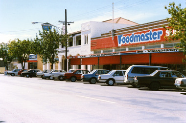
Photograph, Foodmaster Supermarket High St Charlton
Originally Luth's General Store purchased from John Flug in 1875. Renovated and enlarges several times over the years. Business sold to Wignall's in 1971, then O'Donnell's, Currans, Carroll & H?son (C&H) and Graeme Paterson purchased the building in 1986. Colour photograph of Foodmaster SUPERMARKET. Signage on the verandah reads C&H LICENCED SUPERMARKET, WOOL, HABERDASHERY. Red blinds down on verandah. Cars parked along the street in front of buildings. White two story building next door, sIgnage reads EAST CHARLTON HOTEL. Sign above building for Quality MEATS further down the street.luth's general store, john flug, wignall's, o'donnell's, curran, c&h, graeme paterson -
 Bendigo Historical Society Inc.
Photograph - POLICE BUILDING SITE, BULL STREET, BENDIGO, AFTER DEMOLITION
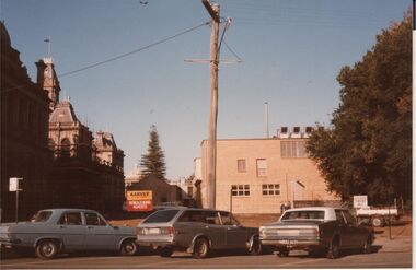
Colour photo: site of former Police Headquarters, Bull Street, Bendigo. Law Courts and former Post Office building on LH side. Site is clear of all building demolition works apart from small trailer. Sign on front wire fence 'Arvee Demolitions'. Three cars parked on kerbside in front - possibly late 1970's?organisation, government, police headquarters, bull street, bendig -
 Bendigo Historical Society Inc.
Photograph - AULSEBROOK AND MARTIN COLLECTION: LAW COURTS PALL MALL
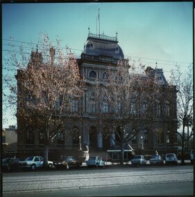
Colour photo: Law Courts, Pall Mall, Bendigo. Cars parked kerbside in front of building, pedestrian seat with roof on pavement edge. Trees on roadside, tram tracks in foreground. Photo appears to be 1980's. Stamped on back of photo 'Aulsebrook & Martin Pty Ltd., Photographers, 6 Ruth St., Golden Square 3555 Phone 054 437565bendigo, buildings, law courts pall mall -
 Bendigo Historical Society Inc.
Photograph - LONG GULLY HISTORY GROUP COLLECTION: LONG GULLY JNR BRIGADE 1901
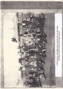
Copy of a black and white photo of the Long Gully Jnr Brigade Easter 1901 at the Old Bendigo Showgrounds, Park Road.Most of the boys are dressed in uniform and wearing a variety of different hats. Their is a variety of ages and they have one man with them. There is a small cart with flowers on it and another floral arrangement beside it. The photo is taken at the Old Bendigo Showgrounds and there are tents in the background.bendigo, history, long gully history group, the long gully history group - long gully jnr brigade 1901, old bendigo showgrounds -
Bendigo Historical Society Inc.
Photograph - LA TROBE UNIVERSITY BENDIGO COLLECTION: BENDIGO TEACHERS' COLLECTION
A black and white photograph of an arial view of Bendigo Teachers' College from the Lookout Tower in Rosalind Park in the 1950's. Room 2 is the old Police stable and there are two aluminium pre-fabs. The other rooms are 3 and 4 and 5 and 6. The Bendigo jail is in the background. On the far right is the Camp Hill State School. 1950's. See 3320.100bendigo, education, bendigo teachers' college history, la trobe university bendigo collection, collection, bendigo, tertiary education, teacher training, education, photo, photos, photograph, photographs, lookout tower, rosalind park, bendigo jail, bendigo gaol, jail, gaol, police stable, camp hill state school, history, building, buildings, site, place, bendigo teachers' college -
 Bendigo Historical Society Inc.
Photograph - S.E.C. VICTORIA, 1941
Black and White Photo of the S.E.C. Victoria Building, Limerick Castle Hotel is in the background, Opposite the S.E.C. Building is the Laurel Café Dining Rooms. A number of people (12?) looking in the windows. on right side cars angle parked in gutter, Horse with attendant. Rear of photo has 14/3/1941 written in biro and number 25 written in pencil.organization, public utility, electricity company, s.e.c. victoria, sec victoria -
 Bendigo Historical Society Inc.
Photograph - BENDIGO - PANORAMA FROM FIRE TOWER
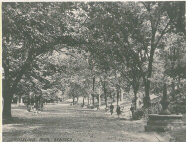
Photograph - sepia. Photograph panorama from Fire Tower, Bendigo.. In the distance shops that I can read 'Mobiloils', 'Cockings', 'Cocks Motor Garage', back view of the Conservatory building and gardens. The Rose Series P.3231. It is written on back but unable to read much, its from Monica. Trees etc along the bottom front are part the rosalind park.Rose Seriesplace, aerial view of bendigo, fire tower., bendigo. panorama from fire tower. -
Clunes Museum
Photograph
THREE PHOTOGRAPHS OF A PARADE 1972: .1 HORSE AND CART WITH "ERNIE THE FASTED IN THE WEST" WRITTEN ON THE SIDE .2 CLUNES HOSPITAL FLOAT- MEDICAL STAFF OPERATING ON THE FLOAT .3 TWO PEOPLE WITH A FULL WHEEL BARROW "A HUM DAINGER" .4 BACK TO SCHOOL, MAN AND WOMEN IN SCHOOL UNIFORM .5 PHOTOGRAPH OF CLUNES CARAVAN PARK 1/04/1972caravan park, back to school, clunes parade 1972 -
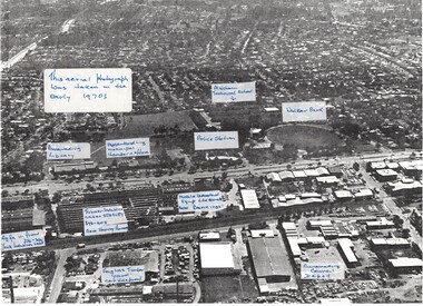 Whitehorse Historical Society Inc.
Photograph, Aerial View of various sites in Nunawading, C.1970's
2 Black and white copies of Aerial View of various sites in Nunawading. - Mitcham Technical School, Walker Park , Nunawading Police Station, Bunnings Warehouse, Mobile Industrial Equipment Ltd, Municipal Chambers, Nunawading Library, Turner Industries, Harvey Norman, Feiglins Timber Yard, Holeproof ,Agfa, York Industries and|City of Nunawading. Council Depot.mitcham technical school, walker park, nunawading police station, bunnings warehouse nunawading, mobile industrial equipment ltd., city of nunawading. council chambers, nunawading library, turner industries, harvey norman, feiglins timber yard, holeproof, agfa, york industries, city of nunawading. council depot -
 Whitehorse Historical Society Inc.
Photograph, Guide Hall, Mitcham, 13/06/1986 12:00:00 AM
2 Coloured photos of Guide Hall, West side of Brittania Street, Mitcham. Formerly jointly used with Scouts and therefore known as Scout Hall. Since demolished. Guides are now located in a purpose built facility on Halliday Park and Scouts likewise in Brunswick Road. These moves were necessitated by the redevelopment of Britannia Street and the former Primary School site.mitcham guide hall, mitcham scout hall