Showing 4841 items matching " road signs"
-
 Canterbury History Group
Photograph - Mr. Ken Buckley outside Buckley's Supermarket at No. 92 Maling Road, Jan Pigot, 27/03/1993 12:00:00 AM
... Canterbury Maling Road Shops Buckley Family Signs Coloured ...Coloured photograph of Mr. Ken Buckley standing outside his supermarket. Visible is a poster outlining specials from the supermarket from a previous era.canterbury, maling road, shops, buckley family, signs -
Canterbury History Group
Photograph - Canterbury Road view of the Canterbury Mansions at No. 208 Canterbury Road, Jan Pigot, 1994
... Signs Coloured photograph of the Canterbury Road view of the 3 ...Coloured photograph of the Canterbury Road view of the 3 storey Victorian Building called Canterbury Mansions. Also depicts the corner roof tower and the sold sign after the auction of the building.canterbury, canterbury road, shops, victorian architecture, signs -
Canterbury History Group
Photograph - Colleen Morgan reading the sign inside the shop at No. 103 Maling Road, Jan Pigot, 27/03/1993 12:00:00 AM
Coloured photograph of Colleen Morgan reading the sign inside Time For Tea gift shop at No. 103 Maling Roadcanterbury, maling road, shops, morgan family -
Canterbury History Group
Photograph - Signs on the wall of the Canterbury Post Office at No. 206 Canterbury Road, Canterbury, Jan Pigot, 1994
... Canterbury Maling Road Canterbury Post Office Signs ...Coloured photograph of signs on the wall of the Canterbury Post Office at No. 206 Canterbury Road, Canterburycanterbury, maling road, canterbury post office, signs -
Canterbury History Group
Photograph - Pharmacist Grace D'Annibale standing at the front door of No.94 Maling Road, Jan Pigot, 27/03/1993 12:00:00 AM
... Canterbury Maling Road Shops D'Annibale Family Signs Paving ...Coloured photograph of pharmacist, Grace D'Annibale holding her motar and pestle standing at the front door of her pharmacy at shop No. 94 maling Roadcanterbury, maling road, shops, d'annibale family, signs, paving -
Canterbury History Group
Photograph - Shop No. 94 maling Road on the east corner of Maling Road and Bryson Street, Jan Pigot, 27/03/1993 12:00:00 AM
... Canterbury Maling Road Shops Paving Trees Signs Coloured ...Coloured photograph of pharmacy shop No. 94 on the corner of Maling Road and Bryson Street.canterbury, maling road, shops, paving, trees, signs -
Canterbury History Group
Photograph - Street view of shop at No 4 - 6 Bryson Street, Jan Pigot, 1994
... Canterbury Maling Road Shops Bryson Street Signs Coloured ...Coloured photograph of the street view of the Commonwealth Bank at No. 4 - 6 Bryson Streetcanterbury, maling road, shops, bryson street, signs -
Canterbury History Group
Photograph - Street view of the enamelled picture plaque of the former Canterbury Station, Jan Pigot, 2004
... Canterbury Maling Road Theatre Place Shops Signs Plaques ...Coloured photograph of the street view of the enamelled picture plaque of the former Canterbury Station on the brick wall at No. 111 Maling Road, Canterburycanterbury, maling road, theatre place, shops, signs, plaques -
Canterbury History Group
Photograph - Street view of the enamelled picture plaque of the former Canterbury Station, Jan Pigot, 2004
... Canterbury Maling Road Theatre Place Shops Signs Plaques ...Coloured photograph of the street view of the enamelled picture plaque of the former Canterbury Station on the brick wall of No. 111 Maling Road, Canterburycanterbury, maling road, theatre place, shops, signs, plaques -
Canterbury History Group
Photograph - Photograph of the enamelled picture plaque of the former Canterbury Station, Jan Pigot, 2004
... Canterbury Maling Road Theatre Place Shops Signs Plaques ...Coloured photograph of the enamelled picture plaque of the former Canterbury Station. There are 2 copies of this photograph in the pocket.canterbury, maling road, theatre place, shops, signs, plaques -
 Bendigo Historical Society Inc.
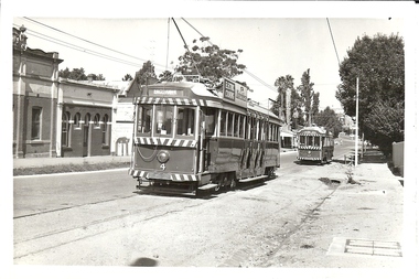
Photograph - BASIL MILLER COLLECTION: TRAMS - SIMPSON'S ROAD, EAGLEHAWK, unknown
BHS CollectionBlack and white photo. Trams No. 4 and 17 on Simpsons Road, Eaglehawk. Tram in forefront has 'Eaglehawk' destination sign. basil miller, bendigo tramways, simpsons road eaglehawk -
 Mont De Lancey
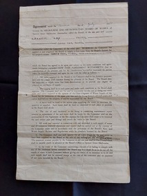
Document - Land Agreement, Melbourne and Metropolitan Board of Works, 02/07/1951
A double sided official original page Agreement between the Melbourne and Metropolitan Board of Works at Spencer Street Melbourne and Maxwell Hay Proctor for the supply of water to the Queens Road Wandin property on the Second day of July 1951.A double sided official original page Agreement between the Melbourne and Metropolitan Board of Works at Spencer Street Melbourne and Maxwell Hay Proctor for the supply of water to the Queens Road Wandin property on the Second day of July 1951. It has The Common Seal of the Melbourne and Metropolitan Board of Works affixed in the presence of the Chairman, Member and Acting Secretary. It is signed Sealed and Delivered by the said Maxwell Hay Proctor in the presence of the witnesses D. Campbell and J.D.It has 'The Common Seal of the Melbourne and Metropolitan Board of Works affixed in the presence of the Chairman, Member and Acting Secretary. It is hand signed Sealed and Delivered by the said Maxwell Hay Proctor in the presence of the witnesses D. Campbell and J.D.'administrative records, documents, land agreements, melbourne metropolitan board of works -
 Mont De Lancey
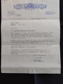
Document - Shire of Lillydale: Planning Application, Shire of Lillydale, 12th September, 1974
Vintage legal documents for land division in Victoria, especially those predating the Torrens system (October 1862), are often found in the Public Record Office Victoria (PROV). These documents, like deeds and Crown grants, can help trace the history of land ownership and division. A letter from K.H. Scott, Shire Engineer of the Shire of Lillydale Victoria to M. H. Proctor Re: Planning Application P.S./833. It is typed on the blue elaborately printed Shire letterhead and dated 12th September, 1974. The application from Mr Proctor to subdivide land situated and described as C.C. 12 Sec B Queens Road., Wandin was granted. Conditions apply.Signed 'Yours faithfully K H Scott K.H. Scott Shire Engineer' 'In reply please quote 1832:74 MGE:DW'legal documents, contracts, documents, indentures -
 Mont De Lancey
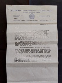
Document - Land Permit to Subdivide Land, Melbourne and Metropolitan Board of Works, 5th July 1974
Vintage legal documents for land division in Victoria, especially those predating the Torrens system (October 1862), are often found in the Public Record Office Victoria (PROV). These documents, like deeds and Crown grants, can help trace the history of land ownership and division. A letter from the Melbourne and Metropolitan Board of Works stating the application by Mr M. H. Proctor of Wandin dated 23rd April, 1974 for a permit to subdivide land in Wandin Yallock has been approved by the Board on 23 April, 1974. There are conditions required. The letter is signed: 'Yours faithfully, (O.T. W. Cosgriff) Assistant Secretary' for 'Mr. M. H. Proctor, Queens Road, Wandin, 3139. 'Board's Reference: Appln No, TP 76484'legal documents, contracts, documents, indentures -
 Eltham District Historical Society Inc
Document - Property Binder, 970 Main Road, Eltham
Business flier: Eltham Bookshop, post 2013. Newspaper advertisement: The Weekly Review, 27 May 2015. Newspaper article: Read all about it!, Eltham Town, Copperline Inaugural Edition October 2022 Newspaper article: One sign of peace, possibly Diamond Valley News, n.d. Flyer: Eltham Bookshop event "My Four Lives" Flyer: Eltham Bookshop event "Wanderers and Dreamers" Newspaper advertisement: Leader Associated Newspapers, Eltham Centenary Supplement, March 30, 1971, Eltham Real Estate Pty Ltdmain road, eltham, shops, businesses, eltham book shop, meera govil, 970 main road, eltham bookshop, eltham real estate pty ltd, midway arcade -
 Bendigo Military Museum
Postcard - CHARLEROI, BELGIUM, c.WW1
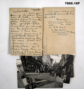
In the letter to his mother R.H. Baron talks about going on leave and visiting Brussels and Antwerp. Part of the Robert H. Baron (No. 3596).and Cooper Collections. See Catalogue No. 1981P for details of Baron's service.1. to 18. Black and white postcard scenes of Charleroi, Belgium. Perforations along left hand side of each card.1. Handwritten on black ink on front "Station". 2. Handwritten in black ink on front. "entrance to town". 1. & 2. Handwritten in black ink on back: "Letter to R.H. Baron's mother signed Bob. Dated 30/3/19." 3. Handwritten on black ink on front: "Road to College".robert h. baron, cooper collection, postcards, ww1, charleroi. -
 Melbourne Tram Museum
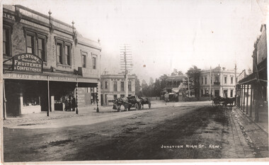
Photograph - Kew Junction looking South West - horse tram, c1900
Photograph, from a postcard titled "Junction High St Kew." shows a horse tram at Kew Junction in Church St about to turn into High St. Buildings in the view are F O Stowe Fruiter Confectioner, Alice cycle works, a tobacconist advertising Havelock tobacco sign, and Collins Kew Hotel. There are three horse-drawn carts, one with a horse eating from a chaff bag.Yields information about Kew Junction c1900.Black and white photograph with notes on the rear.Has on the rear in pencil "Horse tram in Barker Road Kew" and number "185"tramways, horse trams, kew junction, high st kew, church st -
![Photograph - F19 [Eastern Freeway] signage, Ron Setford](/media/collectors/550653872162f11fb04854aa/items/67cbd645494c4da380443cdc/item-media/67cbd667494c4da380443e24/item-fit-380x285.jpg) Kew Historical Society Inc
Kew Historical Society IncPhotograph - F19 [Eastern Freeway] signage, Ron Setford
Ron Setford and his wife Grace Setford lived in Tanner Avenue, East Kew, from c.1946 to c.1995. A keen photographer, he recorded the changing face of Kew over a 20 year period. Apart from 30 photographs of built structures and places in Kew dating from 1960 and 1961, 145 of his 35mm colour slides chronicle the development of the F19 (later renamed Eastern) Freeway through the Yarra Valley in Kew over a five year period from c.1972 to c.1977. This important collection was donated to the Society by his granddaughter in 2025.This collection of 175 35mm slides is of local and statewide significance, owing to its subject matter, particularly the major development of road transport infrastructure during the 1970s with the construction of the Eastern Freeway. The photographer also took care to annotate and date most of his slides which enable the researcher to pinpoint temporal and spatial locations.View of a sign stating the start date of construction on the Eastern (F19) Freeway"Title slide / Eastern Freeway"ron setford, eastern freeway, f19 freeway -
 Bendigo Historical Society Inc.
Document - NEW CHUM & VICTORIA LINES OF REEF - NOTES ON THE VICTORIA REEF GOLD MINES COY
Handwritten notes describing the journey along Eaglehawk Road from the houses, poppet heads and mine tailings, etc. When the alluvial diggings were showing signs of exhaustion, and the fear arose that Bendigo was 'about done', two 'darkies' One named Dido, struck golden stone. They sold out to Ballerstedt and Son, and thus gold mining was revived. These areas were remarkable for the extraordinary richness of the lodes, and the singular manner in which the gold is distributed.document, gold, new chum & victoria lines of reef, notes on the victoria reef gold mines coy, gavan duffy, victoria hill, black lead, prince alfred, ballerstadt & son, goldfields registry, mr macartney, wittscheibe, luffsman -
 Bendigo Historical Society Inc.
Photograph - Victoria Hill, Bendigo, 1973
Gold was discovered on Victoria Hill in 1854 and by 1861, 1,200,000 ounces of gold had been extracted from the site. The first claim was bought for 80 pounds by Prussian immigrant Christopher Ballerstedt and his son Theodore. Christopher Ballerstedt was nicknamed the "Father of the Hill" and was the first to prove that gold reefs extended below the surface. His 200-foot plus mine shafts yielded quartz rich with gold, inspired other miners, and were instrumental in Bendigo becoming the world's deepest and richest goldfield. The site still features relics of nineteenth century mining including quartz crushing machinery and the foundations of George Lansell’s 180 mine. These features are characteristic of Bendigo’s mining history and represent two prominent nineteenth century miners, Christopher Ballerstedt and George Lansell, who held important roles in the development of Bendigo. Victoria Hill Quartz Gold Mines are registered as a site of significance. The site is of historical, archaeological and scientific importance to Victoria. The mines represent the symbolic heart of Bendigo’s gold mining history and the importance that mining played in wealth creation and the development of Victoria. The diggings reserve is accessed from the rear of Albert Richardson Reserve located at 40-56 Marong Road, Ironbark. The site has steep and unformed paths and is closed to the public at dusk. It is important to stay to the paths to avoid the diggings. Interpretive signs help visitors to appreciate the importance of the site and the remaining relics of Bendigo’s mining history.Victoria Hill Ironbark, Bendigo. Photos of the poppet head, sand heap, tailings, shafts and tunnels. Before development into a tourist attraction.history, bendigo, victoria hill, ironbark, diggings -
 Ballarat Tramway Museum
Photograph - No.14 at Sturt & Doveton Sts, Circa late 1950s
Photograph shows Tram 14 Eastbound at cnr of Sturt & Doveton Sts. Destination box shows Victoria St. King George V monument is in road central reservation. Adjacent Tram Stop pole has a sign directing to RACV Service Station. Circa late 1950s.Yields information about tram 14 at Doveton St.Black and white print on plain paper.tramcars, trams, secv, tram 14, sturt st, doveton st -
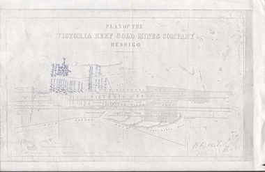 Bendigo Historical Society Inc.
Document - VICTORIA HILL - PLAN OF THE VICTORIA REEF GOLD MINES COMPANY
Plan of the Victoria Reef Gold Mines Company, Bendigo showing the Eastern Victoria Reef, Victoria Reef and the Western Victoria Reef. Streets, gullies and leases drawn in. Some amounts of money and names have been written on the page. Signed by H. B. Nicholas. Locations of Ballerstedt's, Luffsman's, Wittscheibe's, Midway Co and Rae's engines are shown. Ironbark, Derwent, Providence and Long Gullies are shown. Also Mount Korong Road. Leases mentioned are: Jackson, Burrows, Wybarndt, Ballerstedt, Luffsman, Roberts, Ashley, Grant, Troy, Tezeau, Woodward, Croath, Taylor, Cranshaw, Gou?d & Co, Midway, Wittscheibe, Specimen Hill Co, Endeavour, Albert Co, Ballerstedt & Son, Hy? Co, and Wheadon.document, gold, victoria hill, plan of the victoria reef gold mines company, h b nicholas, spiers, jackson, burrows, wybarndt, ballerstedt, luffsman, roberts, ashley, grant, troy, tezeau, woodward, croath, taylor, cranshaw, gou?d & co, midway, wittscheibe, specimen hill co, endeavour, albert co, ballerstedt & son, hy? co, and wheadon -
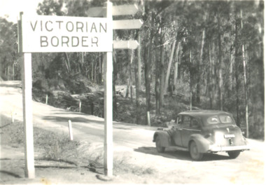 Lakes Entrance Historical Society
Postcard, Victorian Border sign East Gippsland Victoria, 1940 c
Black and white postcard showing a sedan driving by the Victorian Border sign East Gippsland Victoriaroads and streets, topography, vehicles -
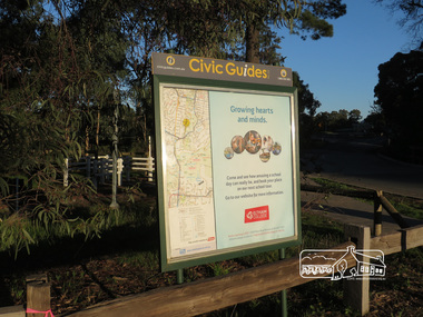 Eltham District Historical Society Inc
Photograph, Liz Pidgeon, Heritage Excursion; Eltham Lower Park, 1 July 2017
Civic Guide sign near the entrance of Eltham Lower Park with a map of the local area and an advertisement for Eltham College Newsletter No., 234, June 2017 Heritage Excursion - Saturday 1st July - Eltham Lower Park - Walk and Talk Eltham Lower Park has played an important part in the history of our area since the early days of European settlement when it was used by local residents as an informal racecourse. Prior to that its location at the junction of the Diamond Creek and the Yarra River made it an important meeting place for the Wurundjeri people. The park combines formal elements and sporting facilities with remnant bushland that is of environmental significance. It is home to sporting and horse riding clubs, popular play spaces and the Diamond Valley Miniature Railway, which attracts large numbers of visitors. The park will be the venue for our July excursion which will comprise a walk of about 3.5 km around the park and adjacent areas. Along the way we will discuss the history and natural history of the area. The path along the creek and the river provides a pleasant and scenic walk. This walk on Saturday 1st July is about 3.5 km in length and will take 2 to 2.5 hours. It will start at 2pm at the Main Road car park at the front of the park. (Melway ref 21 H 10). This sign was removed in about 2021 when works began on the building of an intersection to replace the roundabout at Fitzsimons Lane & Main Road. By May 2023 plantings in green spaces near Eltham Lower Park took place before the official opening of the new Eltham Gateway.Born Digitalheritage excursion, activities, eltham district historical society, eltham lower park, civic guide, eltham college, sign -
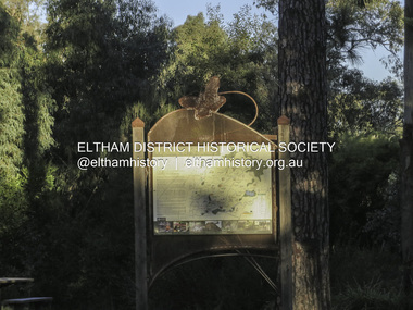 Eltham District Historical Society Inc
Photograph, Liz Pidgeon, Heritage Excursion; Eltham Lower Park, 1 July 2017
Sign at the front of the park which includes a map. Newsletter No., 234, June 2017: Heritage Excursion - Saturday 1st July - Eltham Lower Park - Walk and Talk Eltham Lower Park has played an important part in the history of our area since the early days of European settlement when it was used by local residents as an informal racecourse. Prior to that its location at the junction of the Diamond Creek and the Yarra River made it an important meeting place for the Wurundjeri people. The park combines formal elements and sporting facilities with remnant bushland that is of environmental significance. It is home to sporting and horse riding clubs, popular play spaces and the Diamond Valley Miniature Railway, which attracts large numbers of visitors. The park will be the venue for our July excursion which will comprise a walk of about 3.5 km around the park and adjacent areas. Along the way we will discuss the history and natural history of the area. The path along the creek and the river provides a pleasant and scenic walk. This walk on Saturday 1st July is about 3.5 km in length and will take 2 to 2.5 hours. It will start at 2pm at the Main Road car park at the front of the park. (Melway ref 21 H 10). This sign was removed in about 2021 when works began on the building of an intersection to replace the roundabout at Fitzsimons Lane & Main Road. By May 2023 plantings in green spaces near Eltham Lower Park took place before the official opening of the new Eltham Gateway. The sig Born Digitalelection day, heritage excursion, activities, eltham district historical society, eltham lower park, sign -
 Bendigo Historical Society Inc.
Newspaper - LONG GULLY HISTORY GROUP COLLECTION: E BRYANT - GROCER
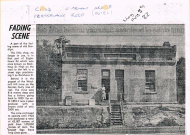
BHS CollectionCopy of a newspaper article titled Fading Scene. Photo shows a building with a stairway leading down to the road in front of it and a lady standing in the doorway. One window has Cash Store printed on it and there are two placards leaning on the building to the left of the lady. Each side of the building are shrubs and picket fence. In the background to the left is the poppet of the Windmill Hill Mine on the Garden Gully line of reef. It is in that part of Eaglehawk Rd which was once known as Backhaus St. High on the wall to the left is a street sign proclaiming it as Backhaus St. Written above the photo is C-sh, E Bryant, Gro-er (there are holes through the words), Perseverance Reef (Hotel). Wed Feb 3rd 82. Article is mounted on yellow card which is mounted on purple card and laminated.bendigo, history, long gully history group, the long gully history group - e bryant - grocer, windmill hill mine, garden gully line of reef, e bryant, perservance reef (hotel) -
 Lakes Entrance Historical Society
Postcard - Sylvia Gasson, Bulmer, 1914 to 1920 c
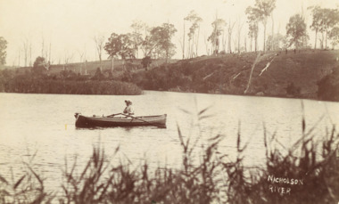
Also a second photograph of Mrs Gasson rowing a boat on the Nicholson river old road bridge in background showing central lifting span which never worked 05348.1Black and white postcard of woman Sylvia Gasson in a row boaty on Nicholson River Hill opposite shows signs of being cleared of trees Nicholsong VictoriaNicholson Rivertransport, agriculture, genealogy -
 Melbourne Tram Museum
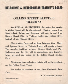
Document, Melbourne & Metropolitan Tramways Board (MMTB), "Collins Street Electric Tramway", Dec. 1929
Set of two Notices to Passengers regarding changes resulting from the opening of the Collins St electric lines to Victoria Bridge as of 8/12/1929. Signed by A D Murdoch, Manager. 1 - Collins St Electric Tramway - noting that the bus service will be discontinued, and electric trams to Victoria Bridge. Existing fares remain applicable but no workmen's fares. 2 - St Kilda Beach - Kew Route - trams will terminate at Glenferrie and Cotham Roads, rather than running to Victoria Bridge. Details fares for the route.Yields information about the opening of the Collins St electric tram service in 1929 and other changes.Set of two Notices printed on quarto paper.Both have "Manager" in top right hand corner.tramways, buses, new tramway, collins st, tram routes, kew -
 Lakes Entrance Historical Society
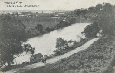
Postcard - Eagle Point bluff, silt Jetties and Jones' Bay, Eagle Point Victoria, A W Burman Bairnsdale, 1912 c
Letter on back dated Dec 30 1912 to Mrs Brewer Signed FloraBlack and white postcard showing view of Mitchell River looking east towards Eagle Point bluff and the silt Jetties and Jones' Bay small farm and buildings, hop kiln on bank opposite bluff and hop paddock. Horse and jinker on gravel road Eagle Point VictoriaMitchell River Eagle Point Bairnsdale waterways, rivers, jetties, roads and streets, transport -
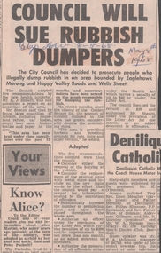 Bendigo Historical Society Inc.
Newspaper - VICTORIA HILL - RUBBISH DUMPERS AT VICTORIA HILL
Newspaper article from the Bendigo Advertiser dated 8/5/68. Article mentions that the City Council has decided to prosecute people who illegally dump rubbish in an area bounded by Eaglehawk Marong and Happy Valley Roads and Wells Street. Rubbish had been dumped there despite the prohibiting signs. Numerous notices have been served on the people responsible for dumping the rubbish.newspaper, bendigo advertiser, victoria hill, rubbish dumpers at victoria hill, bendigo advertiser 8/5/68, bendigo city council, mr k j shearn