Showing 9613 items
matching water-rates
-
 Dunkeld Museum Inc.
Yoke, Late 19th Century
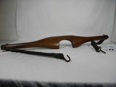
The yoke was made by a farmer in Silesia for his daughter to use on the family farm. When the family migrated to Australia the yoke was brought with them. It was used for carrying buckets of milk, vegetables, water or other farm supplies. It has been used by various family members until recent times.Woman's agricultural yoke. Timber body carved to fit the neck and shoulders of the wearer with round extensions either end. Leather straps are suspended from slots in these round extensions close to the end and are held into the timber with metal nails. One strap has been repaired and joined with brass rivets. A metal hook hangs on the bottom of each leather strap and these are held in place by a brass rivet.yoke, silesia, milking -
 Halls Gap & Grampians Historical Society
Newspaper - B/W, 29/12/2000
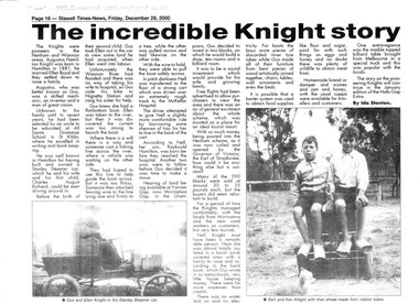
This is a newspaper article about the Knight family. It was written by Ida Stanton for the Stawell Times-News "Halls Gap Extra" and was published on Friday, 29 December 2000, p.16. The photos included in the article are C 1881. For more information see "Victoria's Wonderland", "Water between the hills".A newspaper article headed "The Incredible Knight story", containing two photos. The photos are of a couple (Gus and Ellen Knight) in a Stanley Steamer car; and two boys (Bert and Ken Knight) sitting on a pile of boxes with a small dog in the foreground. They are wearing shoes made from rubber tubes.people, knight -
 Geelong Cycling Club
Sash, 1952
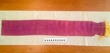
The sash was awarded to G. Lunardelli as the winner of the Senior 20 mile Road Championship for GWCC. Lunardelli came out from Trieste, Italy after World War 11 and worked for the Geelong Water Board. Lunardelli subsequently ceased full time cycling in order to make a living.This award indicates the important influence that immigrants had on the popularity and depth of cycling at the time in the Geelong region. Cycling was and continues to be very popular in Europe.Burgundy satin sash with gold tassel finish at one end. It has faded gold embossed inscriptions on it."Geelong West Cycling Club/1952 Senior 20 Mile Unpaced/Road Championship/ Won by G. LUNARDELLI/Time 56mins5 2/5 seconds"sash; geelong west cycling club; lunardelli; 1952; road championship; -
 Tatura Irrigation & Wartime Camps Museum
Print - Heaphy's Whim - Inn Framed Print, Heaphy's Whim Inn
The inn was located on the SW corner of the intersection now known as Dhurringile Rd and Hogan St. There is now no trace of the pictured building. This was the northern boundary of the James Winter estate and was called " Nelson Gate ". The town "whim " ( water pump ) was near the Brown St / Albert St round-a -boutBlack and white print in a black plastic frame with white card surround. Inn with horses and carts, people in the carts, people standing under verandah and off to the side. Wide section of road in front and trees behind -
 Queenscliffe Maritime Museum
Tool - Navigation, ship's Log, 25 May 2011
A Ship's Log looked very similar to a torpedo but was used to measure the speed of a ship. When dragged behind the vessel, movement of water past the propeller caused it to rotate, turning the small needle dials to record the distance and speed travelled. https://museumsvictoria.com.au/immigrationmuseum/resources/journeys-to-australia/Ship's Log Display HeadWalkers Cherub 111 ships lognavigation, speed, knot, chip log, log, thomas walker and son -
 Wodonga & District Historical Society Inc
Album - Ringer's River by Des Martin - Plate 27 - Erin swims the river with a warning
Erin swims the river when she finds herself too late to reach the drovers before their crossing; and amazes O'Day and Keiran when she arrives with the news that the police have them cut off. Behind her a major storm up river is causing the water to rise.The album and images are significant because they document literature written by a prominent member of the Wodonga community. The presentation of this precis was supported by several significant district families and individuals.Ringer's River Album Coloured photo Plate 27des martin, many a mile, ringer's river, northeast victoria stories -
 Bendigo Historical Society Inc.
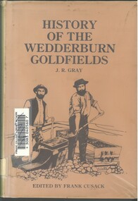
Book - HISTORY OF THE WEDDERBURN GOLDFIELDS, 1888
Gold was first discovered in 1852 on what was then named Korong or Mt Korong goldfields. It was soon found that the area was not suitable for alluvial mining because of a lack of water but quartz mining was more successful. The township of Wedderburn was surveyed 1856/57. The first public crushing works was established in 1859.Hardcover book with printed dust jacket and plastic cover. 92 pages with black and white illustrations, fold out map and index. Covers the history of the Wedderburn Goldfields and the discovery of gold generally in Australia from the 1850s until c1880s. Written by Joshua R Gray and edited by Frank Cusack.Joshua R Gray and Frank Cusack.gold, goldfields, goldfield -
 Bendigo Historical Society Inc.
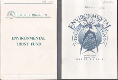
Booklet - Kangaroo Flat Gold Mine Collection: Environmental Trust Fund Policy booklet
The Bendigo Environmental Trust was established in 1995 with funds provided by Bendigo Mining NL. The Trust was administered by an honorary Board of Trustees. Preference was given to projects that reflected the philosophy of the Bendigo Region Conservation Strategy, namely flora and fauna, energy conservation, land and water protection and waste management. Two copies of an eight page booklet titled ' Environmental Trust Fund, sponsored by Bendigo Mining NL. One booklet date stamped 4 Sep 2002. Content identical in both: policy; how the Bendigo ining Environmental Trust works; who can apply; areas supported; how to apply; preferred format; limitations of grants; support period; when to apply, where to apply and project documentation required.Date stamp September 2005 on one copy.bendigo mining nl, environment, environmental trust, flora and fauna, energy conservation, waste management, land and water protection, kangaroo flat, goldmining -
 Kiewa Valley Historical Society
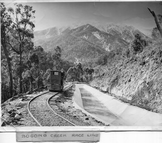
Photo - Bogong Creek Race Line
The SECV constructed the Kiewa Hydro Electric Scheme which included race lines to catch the water and feed it into the dams that they built to create hydro electric power. The rail line was used to construct the race line and enables the race line to be easily checked for maintenance eg. fallen trees The SECV constructed the Kiewa Hydro Electric Scheme from the late 1940s to 1961 being one of the first hydro schemes and hence environmently friendly.Shiny black and white photo showing the railway track, with a locomotive on it, beside the race line. Snow is on the surrounding mountains. ;Bogong Creek Race Line in pen and attafhed to the photo. On the back "Property of / State Electricity Commission of Victoria/ Publicity photo / Permission to Publish must be obtained / and acknowledgement made. / Negative No. 14-138bogong creek race line, kiewa hydro electric scheme -
 Ballarat Tramway Museum
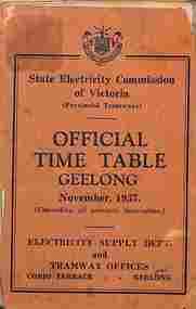
Ephemera - Timetable, State Electricity Commission of Victoria (SECV), "Official Timetable Geelong", November 1937
Gives details of the fares, transfers, luggage or parcels, lost property, times of each tram on the Newtown, West Geelong, East Geelong, Chilwell, Eastern Park, Belmont,, North, Dated Nov. 1937. Has adverts for SEC domestic appliances eg toasters, refrigerators and hot water.Yields information the 1937 tramway services in Geelong and SECV advertising domestic appliances.Printed booklet - was centre stapled - part of two timetables included within one cover. One loose sheet.secv, tramways, geelong, timetables -
 Kew Historical Society Inc
Photograph, Marnie McLeod, Floods of the River Yarra at Kew, 1916
The donation was accompanied by the following letter from the donor: "Hi. I found these in with family photos. Taken by family as Mamie McLeod was living in Fellows Street, Kew, so would be near there. Retain (or discard) as you see fit." [Donor's name and address withheld from public view]. To gain an insight into the flood levels at Kew, it is worth reading newspaper accounts of the event. The Age published an article - Valuable Gardens Destroyed at Kew - on 25 September 1916: "VALUABLE GARDENS DESTROYED AT KEW. From the heights of Studley Park, Kew, a splendid view of the flood waters can be obtained, and yesterday afternoon, despite continuous rain, crowds of citizens assembled there to witness the spectacle. There is a vast stretch of water some 300 or 400 yards broad, above the foot bridge connecting Gipps-street, Collingwood, and Studley Park. The river is only about 3 feet from the top of the embankment connecting with the ramp of the bridge on the Studiey Park side. When the upper llood waters come down it is almost a certainty that tne embankment will be submerged and the bridge rendered impassible. Below the bridge the waters again stretch out, and have submerged all the low-lying land on the Collingwood side and invaded the back premises ot the Kodak Co., Phoenix Biscuit Factory, a tannery adjoining thereto, the Shamrock Brewery, and Chinese gardens in the vicinity. At Walmer-street-bridge, at the end of Studley Park, the low-lying land on the Kew side is covered with water to the depth of many feet. Tlie land in question is owned in a great part by Mr Frank Lavers who haa gone in for intense culture on a pretty liberal scale on both the slopes of the hill and on the river flat. On the latter he is cultivating many acres of asparagus, and has at a considerable cost spent three years in preparing the ground and installing an irrigation system, reticulated from the Yan Yean water supply. This year the asparagus was put down, and the plants were in a promising condition. Tlie flood waters are now flowing fast over the land. The crop is ruined, and three years' work and expenditure destroyed. Mr. Laver's private residence fortunately is high above flood level, but two houses he owns off Young-street have been flooded out. Having been warned in time, the tenants removed their furniture hefore the water came down to Mr. Laver's residence, where they themselves have been given accommodation in the meantime. All the river flats in East Kew are under water. One or two low-lying houses have been flooded. Chipperfield's boat shed at Willsmere is nearly covered, and some Chinese gardens in the vicinity are several feet under water."This, and the other three photographs donated of floods in Kew are believed to be the earliest in the collection. Together with our original MMBW River Yarra map showing flood levels, these items, when compared allow researchers to gain a visual perspective of the extent of the flood in 1916. Black and white photograph of flooded trees in Kew with rising dry ground in distance.Inscription on reverse in pencil: "Flood River Yarra Kew Vic"river yarra, kew, floods 1916 -
 Kew Historical Society Inc
Photograph, Marnie McLeod, Floods on the River Yarra at Kew, 1916
The donation was accompanied by the following letter from the donor: "Hi. I found these in with family photos. Taken by family as Mamie McLeod was living in Fellows Street, Kew, so would be near there. Retain (or discard) as you see fit." [Donor's name and address withheld from public view]. To gain an insight into the flood levels at Kew, it is worth reading newspaper accounts of the event. The Age published an article - Valuable Gardens Destroyed at Kew - on 25 September 1916: "VALUABLE GARDENS DESTROYED AT KEW. From the heights of Studley Park, Kew, a splendid view of the flood waters can be obtained, and yesterday afternoon, despite continuous rain, crowds of citizens assembled there to witness the spectacle. There is a vast stretch of water some 300 or 400 yards broad, above the foot bridge connecting Gipps-street, Collingwood, and Studley Park. The river is only about 3 feet from the top of the embankment connecting with the ramp of the bridge on the Studiey Park side. When the upper llood waters come down it is almost a certainty that tne embankment will be submerged and the bridge rendered impassible. Below the bridge the waters again stretch out, and have submerged all the low-lying land on the Collingwood side and invaded the back premises ot the Kodak Co., Phoenix Biscuit Factory, a tannery adjoining thereto, the Shamrock Brewery, and Chinese gardens in the vicinity. At Walmer-street-bridge, at the end of Studley Park, the low-lying land on the Kew side is covered with water to the depth of many feet. Tlie land in question is owned in a great part by Mr Frank Lavers who haa gone in for intense culture on a pretty liberal scale on both the slopes of the hill and on the river flat. On the latter he is cultivating many acres of asparagus, and has at a considerable cost spent three years in preparing the ground and installing an irrigation system, reticulated from the Yan Yean water supply. This year the asparagus was put down, and the plants were in a promising condition. Tlie flood waters are now flowing fast over the land. The crop is ruined, and three years' work and expenditure destroyed. Mr. Laver's private residence fortunately is high above flood level, but two houses he owns off Young-street have been flooded out. Having been warned in time, the tenants removed their furniture hefore the water came down to Mr. Laver's residence, where they themselves have been given accommodation in the meantime. All the river flats in East Kew are under water. One or two low-lying houses have been flooded. Chipperfield's boat shed at Willsmere is nearly covered, and some Chinese gardens in the vicinity are several feet under water."This, and the other three photographs donated of floods in Kew are believed to be the earliest in the collection. Together with our original MMBW River Yarra map showing flood levels, these items, when compared allow researchers to gain a visual perspective of the extent of the flood in 1916. Panoramic view, believed to be looking north towards Fairfield from the Zig-Zag Bridge on the River Yarra. The inscription on the reverese identifies it as taken before 1920.Inscription on reverse in ink "(pre 1920) Flood from Zig-zag bridge Yarra River, Kew Vic."river yarra, kew, floods 1916, zig-zag bridge -
 Kew Historical Society Inc
Photograph, Marnie McLeod, Flood, River Yarra, Kew, 1916
The donation was accompanied by the following letter from the donor: "Hi. I found these in with family photos. Taken by family as Mamie McLeod was living in Fellows Street, Kew, so would be near there. Retain (or discard) as you see fit." [Donor's name and address withheld from public view]. To gain an insight into the flood levels at Kew, it is worth reading newspaper accounts of the event. The Age published an article - Valuable Gardens Destroyed at Kew - on 25 September 1916: "VALUABLE GARDENS DESTROYED AT KEW. From the heights of Studley Park, Kew, a splendid view of the flood waters can be obtained, and yesterday afternoon, despite continuous rain, crowds of citizens assembled there to witness the spectacle. There is a vast stretch of water some 300 or 400 yards broad, above the foot bridge connecting Gipps-street, Collingwood, and Studley Park. The river is only about 3 feet from the top of the embankment connecting with the ramp of the bridge on the Studiey Park side. When the upper llood waters come down it is almost a certainty that tne embankment will be submerged and the bridge rendered impassible. Below the bridge the waters again stretch out, and have submerged all the low-lying land on the Collingwood side and invaded the back premises ot the Kodak Co., Phoenix Biscuit Factory, a tannery adjoining thereto, the Shamrock Brewery, and Chinese gardens in the vicinity. At Walmer-street-bridge, at the end of Studley Park, the low-lying land on the Kew side is covered with water to the depth of many feet. Tlie land in question is owned in a great part by Mr Frank Lavers who haa gone in for intense culture on a pretty liberal scale on both the slopes of the hill and on the river flat. On the latter he is cultivating many acres of asparagus, and has at a considerable cost spent three years in preparing the ground and installing an irrigation system, reticulated from the Yan Yean water supply. This year the asparagus was put down, and the plants were in a promising condition. Tlie flood waters are now flowing fast over the land. The crop is ruined, and three years' work and expenditure destroyed. Mr. Laver's private residence fortunately is high above flood level, but two houses he owns off Young-street have been flooded out. Having been warned in time, the tenants removed their furniture hefore the water came down to Mr. Laver's residence, where they themselves have been given accommodation in the meantime. All the river flats in East Kew are under water. One or two low-lying houses have been flooded. Chipperfield's boat shed at Willsmere is nearly covered, and some Chinese gardens in the vicinity are several feet under water."This, and the other three photographs donated of floods in Kew are believed to be the earliest in the collection. Together with our original MMBW River Yarra map showing flood levels, these items, when compared allow researchers to gain a visual perspective of the extent of the flood in 1916. Small black and white photograph of flooded trees in Kew.Inscription on reverse in ink "Flood R. Yarra Kew Vicriver yarra, kew, floods 1916 -
 Eltham District Historical Society Inc
Document - Folder, McDonald, Thomas
Thomas McDonald was born in Hobart in 1836; in 1856 in Heidelberg, he married Mary Anne Maloney, born in County Clare Ireland c1836; Thomas was living in Diamond Creek and Mary Anne on Plenty River. They moved to Eltham and raised a family. Descendant Dan Delmo was researching this family's time in Eltham. Contents Photocopies of emails from Dan Delmo providing details of his family research; certificates of marriages, birth, deaths; letter 4 November 2010 from Lucille Andel with details of Eltham Rate Books. Photocopies of emails from Jim Connor, Eltham District Historical Society, listing McDonald children attending Eltham Primary School.Newspaper clippings, A4 photocopies, etcdan delmo, thomas mcdonald, mary anne mcdonald (nee maloney) -
 Parks Victoria - Wilsons Promontory Lightstation
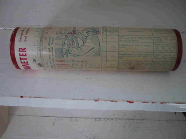
Container, Ventometer
The cylindrical cardboard container with lid formerly contained a ventometer, a small simple tool for measuring wind speed. It consisted of a clear tube containing a small diaphragm which had a hole in the bottom for wind to enter. Once the wind entered the tube it pushed up the diaphragm, indicating the rate of velocity. Ventometers were common devices that have since been replaced by more sophisticated measuring equipment, such as digital air speed meters. Further information on this particular example, including perhaps the name of the manufacturer, may survive on the container but this has not been recorded. The small simple tool for measuring wind speed pre-dates the electronic devices at Gabo Island.Tubed shaped cardboard container with lid to house instrument for measuring. (instrument is missing) Inscriptions and illustrations on exterior. -
 Bendigo Historical Society Inc.
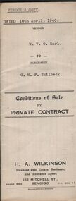
Document - H.A & S.R. WILKINSON COLLECTION: CONTRACT OF SALE
Conditions of sale by private sale dated 10th April, 1940 between W.V.O. Earl (seller) and C.M.F. Skilbeck (buyer) for land situate No.148 Booth Street, Bendigo, being the land described in right to occupy residence area No.4501. Also all the vendor's right, title and interest in that piece of land adjoining the above mentioned land described in permissive occupancy title no. W.52845, together with 5-roomed weatherboard dwelling and all sundry. Also bath, copper and troughs. Price 175 pounds. Attached 5 receipt issued by Department of Lands and Survey plus 2 receipt from City of Bendigo for rates. Vendor's copy.organization, business, h.a. & s.r wilkinson real estate -
 Bendigo Historical Society Inc.
Photograph - SWEENEY COLLECTION: PHOTOGRAPHS, 1920-1940
Photographs Four Photographs a. Portrait of three men, F. C. Sweeney in the middle; written of the rear is '1st July 1929 Umpire's Assoc. Dinner' b. Photograph of wedding invitation to Owen W Smith to the wedding of Doris Whalebone to Mr, F. C. Sweeney. Sent in December 1928. c. Football Club - player and coach, written on the rear is 'Railways 1st Rate Football Club' and a stamp by F.Harrison Photographer 301 Lyttelton Terrace Bendigo. F. C. Sweeney second from left, front row. d. Three family members, written on back with pencil 'G. Grandparents Garsed Street' (of F. C. Sweeney)photograph, person, fc sweeney -
 Falls Creek Historical Society
Document - Victorian Ski Association Report - Growth & Administration Of Skiing In Victoria
Bob (Herman) Hymans (a former member of the Royal Netherlands Navy) was born in Bloemendaal, Holland on 30th September 1922. During World War II he fought against the Japanese in the Dutch East Indies (now Indonesia) and was imprisoned in Changi and on the Burma Railway. After gaining qualifications as a Ski Instructor, Bob arrived in Falls Creek in July 1950. Working as an Instructor and Supervisor at Bogong Lodge, Bob decided his future was in accommodation. He was successful in negotiating an indenture for land from the State Electricity Commission (SEC). It took Bob two years to build his Grand Coeur Chalet but, tragically, it was burned down in August 1961. Bob also built the first Chairlift in Australia. This was a single chairlift and the structure was built from wooden electricity poles. He was constantly full of new ideas and proposals for the village. Bob Hymans died on 7th July 2007. This Collection of documents and letters tells the story of Bob's endeavours to develop Falls Creek into the ski village it is today.This item is significant because it documents the growth of the Skiing Industry in Victoria up until 1966.A detailed report into the "Growth and Administration of Skiing in Victoria" produced by the Victorian Ski Association. Different pages in the report include:- Introduction and contents; reasons for completing this Submission and Summary: Analysis of capital employed on Victoria's snowfields; Facilities of NSW and Vic Ski Resorts; Administration of resorts: the growth of skiing in Victoria; an analysis of resorts at Mt Buller, Falls Creek, Mt. Baw Baw, Mt. Buffalo, Mt. Hotham and Mt. Bogong; Capacity of the present administration to meet challenges related to growth ; the granting of leases to Clubs and Commercial Establishments and an estimate of Capital employed in Ski Facilities in Victoria. It also includes a table and a graph representing the growth rate of skiing in Victoria.falls creek tourist area management committee, falls creek administration, sewerage system falls creek -
 Melbourne Tram Museum
Letter, Public Transport Corporation (PTC), "The Met" Scratch tickets, Dec. 1989
Letter issued on PTC Coloured letterhead, with V/Line and The Met logos on the base, to all tram and bus employees, from Keith Fitzmaurice, discussing pay opportunities, the Tramways Union refusal to participate, Christmas Wishes and looking forward to work together in 1990. Undated as such. Consists of two sheets of paper and two tickets stapled together in the top left hand corner. Attached to the letter is a sheet giving current and proposed pay rates for bus drivers, conductors and tram drivers. Attached to the top of the letter are two "The Met" Scratch tickets, for Dec 1989 to July 1990, Zones 1, 2 and 3 for 1 Adult and 1 Concession traveller.trams, tramways, ptc, unions, tickets, scratch tickets, awards -
 The Beechworth Burke Museum
Audio - Oral History, Jennifer Williams, Evelyn Jensen, 13th April 2000
Miss Evelyn Jensen was born in 1908 near Mytleford Road in Beechworth. Miss Jensen was a twin but she also had twelve brothers and sisters. Miss Jensen went to school when she was nine years old but did not enjoy it. Her father was a nozzleman and had a role in finding and collecting gold. More specifically, a nozzleman operated a steel barrel with an interchangeable brass nozzle that sprayed high pressure water onto rock and similar surfaces. This broke down the surface for gold to be found. Unfortunately, when he began most of the gold was already gone. Miss Jensen's mother died when Miss Jensen was sixteen. As a result, Miss Jensen had to take care of the children and run the house. This included looking after a few months old baby. Her father was away at work most days so all of the responsibility fell on her. Her grandmother was present but she was too old to help Miss Jensen. Miss Jensen and her family lived a very long way from the main town and often had to carry kerosene tins full of water half a mile to their house. This was because they have no access to water at their home. This lack of water also meant they had to either bathe in the creek or carry the water back home for a bath. On wash day, they washed their clothes in the creek too. Miss Jensen never married but continued to provide for her family. She spent her days gardening and cooking. They did not have much money so gardening was a way that they provided food for themselves. This oral history recording was part of a project conducted by Jennifer Williams in the year 2000 to capture the everyday life and struggles in Beechworth during the twentieth century. This project involved recording seventy oral histories on cassette tapes of local Beechworth residents which were then published in a book titled: Listen to what they say: voices of twentieth century Beechworth. These cassette tapes were digitised in July 2021 with funds made available by the Friends of the Burke.Miss Jensen's oral history is significant because it demonstrates the struggles of living remotely during this early part of the twentieth century. When Miss Jensen's mother died, she had to take on a lot of responsibility and did not have much support. This history sheds light on these struggles of being a young caregiver but it also gives details on how large families lived in isolated places. An example of this is the way that Miss Jensen often had to do the washing in the creek because that was the only place there was running water. In addition, Miss Jensen's story is significant because her father was a nozzleman. It indicates one of the processes was used to find gold. This oral history account is socially and historically significant as it is a part of a broader collection of interviews conducted by Jennifer Williams which were published in the book 'Listen to what they say: voices of twentieth-century Beechworth.' While the township of Beechworth is known for its history as a gold rush town, these accounts provide a unique insight into the day-to-day life of the town's residents during the 20th century, many of which will have now been lost if they had not been preserved.This is a digital copy of a recording that was originally captured on a cassette tape. The cassette tape is black with a horizontal white strip and is currently stored in a clear flat plastic rectangular container. It holds up 40 minutes of recordings on each sideEvelyn Jensen /mytleford road, beechworth, three mile creek, three mile beechworth, twin, nozzleman, goldrush, gold rush, work, mother, young mother, children, siblings, baby, grandmother, father, isolation, bush, water, watertanks, kerosene tins, wash day, bath day, creek, gardening, provide, poor, money, oral history, twentieth century, recording, story -
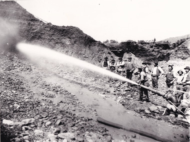 The Beechworth Burke Museum
Photograph - Photograph - Reproduction, Unknown c1852-1940
Depicted in the photograph are ten miners standing at a cliff face using a high pressure hose, in Beechworth, Victoria. The miners are located in the Three Mile Creek division, in the Beechworth Mining District established January 4th 1858 under An Act for Amending the Laws Relating to the Goldfields by the Governor-in-Council. The Ovens Gold Rush began at Beechworth in February 1852 and was followed by Yackandandah and the 'Indigo Goldfield'. The strategies applied to mining in Beechworth were distinct in comparison to other goldfields in Victoria such as Bendigo and Ballarat. The miners in Beechworth utlised 'hydraulic sluicing' to remove washdirt, the long water races and deep tailraces constructed through solid rock with an estimated 900 miles of water races cut through the Beechworth fields by 1880, demonstrating great engineering feats. The photograph taken is significant as it is a visual representation of the mining strategy, 'hydraulic sluicing' that was particularly unique to the Beechworth mines, particularly in Victoria and an engineering feat.Black and white rectangular photograph printed on matte photographic paper, unmounted print.beechworth mining district, mining, three mile creek division, three mile creek -
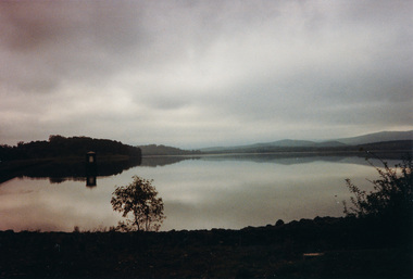 Eltham District Historical Society Inc
Photograph, Sugarloaf Reservoir from Skyline Drive, 1989, 1989
Originally contained in a 'magnetic' photo album believed to have been donated by Mr Eric Stephenson, Jingalong, 110 Ryans Road, Eltham, Vic. 3095; relocated to archival safe storage. Sugarloaf Reservoir is situated on former farmland. This large water storage was completed in 1982 and serves Melbourne's northern suburbs. Within the visitor areas are two picnic grounds and other recreational facilities. Below its massive rock embankment is located the Winnecke Treatment Plan designed to purify its water before being piped into Melbourne. The dam partly inundated the old firing ranges of the former Christmas Hills Rifle Club. Source: Christmas Hills Now and then: Yarra Glen & District Historical Society, 2004. Two colour photographsskyline drive, sugarloaf reservoir -
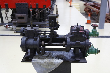 Puffing Billy Railway
Steam Pump, Worthington - Simpson steam driven pump, circa 1917
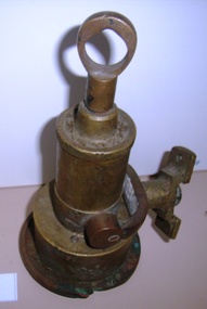
Worthington Steam Pump This type of horizontal duplex steam pump was most commonly made by Worthington-Simpson Ltd., England. It was really two double-acting pumps placed side by side. Worthington pumps of this size would feed a small boiler with water whilst larger similar pumps up to six feet long would be used to pump bulk liquids. This type of horizontal duplex steam pump was most commonly made by Worthington-Simpson Ltd., England. It was really two double-acting pumps placed side by side. Worthington pumps of this size would feed a small boiler with water whilst larger similar pumps up to six feet long would be used to pump bulk liquids.Historic - horizontal duplex steam pump made by Worthington - SimpsonSteam Pump made of Steel, bronzeWorthington-Simson ltd Newark-on-trent England No 5073449 Size 4 1/2 x 2 3/4 x 4puffing billy, worthington steam pump, worthington - simpson -
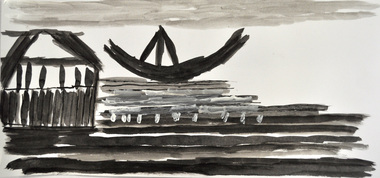 Nillumbik Shire Council
Drawing: Tim RYAN, Tim Ryan, Queenscliff 1,2 and 3, 2012
“Queenscliff (three black and white boat/ship themed set), is a depiction of a trio of sailing vessels, and a typical example of Tim Ryan’s process and style / It illustrates three images from separate editions of National Geographic – a much-loved and constantly revisited source of inspiration / Tim has reduced his subject matter to minimal line, managing to capture the form and character of the scene and the people within with delicacy and sensitivity / As is also a common trait, Tim has discarded the idea of a using a title describing the actual scenes in favour of one that holds much greater personal significance / Queenscliff is the site of his family holiday home, hence a place evoking decades of memories connected with water, horizon and water-based activity and interaction.Tim Ryan has worked within the Studio Art Program at Araluen for almost a decade / Araluen is based in the north eastern suburbs of Melbourne (Nillumbik region), that provides accommodation and day services for adults with an intellectual disability / Creating and sharing artwork is one way Araluen participants express their thoughts, personalities and abilities. The art program allows them to develop a sense of achievement and access society as equal and valued participants / Tim puts a great deal of effort into selecting his subject and arranging his page / He immerses himself in the image, studying it thoroughly and sometimes tracing over it with his finger before commencing / He focuses on the different elements and relationships that inspire, bringing out the lines, colours and shapes most fitted for translation into the picture / Favourite references are photo-laden books and magazines covering topics as broad as nature, history, archaeology, exotic foreign lands and all forms of transport.Three black and white drawings of boats/ships in Queenscliff made using watercolor, ink, fine liner, pencil and acrylic on paper. All drawings are black and white in colour with one drawing rendering a boat in warm red/orange and yellow colours. None shown, catalogue label on backdrawings / black & white / ink / boats / ships / queenscliff / araluen / ryan / disability -
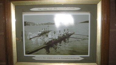 City of Warrnambool Rowing Club
Photograph, The Final for Mrs Rolfe's Trophy
Mrs George Rolfe was the wife of the owner of Lyndoch. He was a Melbourne tea merchant, who owned 216 acres of the Shipley estate further up the Hopkins River. In the late 1870s he bought 2 acres of land and house along the Hopkins near the bridge and developed into Lyndoch. By 1883 he increased to 50 acres. He resoiled the land, put in a water supply reservoir, water tanks and pumps, a reticulation system and a windmill- 50 feet high with four sails 18 feet high and 4 1/2 wide. George Rolfe died in 1919 and the present Lyndoch House was built in 1925. Source: By These We Flourish, A History of Warrnambool by C.E. Sayers and P.L. Yule Edition 1 A4 landscape black and white photograph of a mens rowing four on the Hopkins River, Warrnambool.The Final for Mrs Rolfe's Trophy Presented by Mrs George Rolfe by W.R.C.lyndoch, lyndoch warrnambool, city of warrnambool rowing club, warrnambool rowing club, george rolfe -
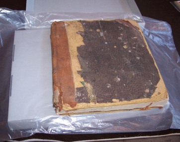 Ballarat Tramway Museum
Administrative record, Electric Supply Co. of Vic (ESCo), "Tramway Traffic Wages Book", 1919 - 1924
Each page of the volume is divided into rows and headed columns. Information appearing in each row includes the name, occupation, rate of pay, days worked and total fortnightly pay. There is provision for each row to contain details for two fortnightly pays. Occupations listed in these entries include driver, conductors and points boys, of various pay rates. See item 9541 for a 1929 to 1934 version. Images of object as follows: .1 - Book - front cover .2 - Book - edge .3 - inside cover and printer's label .4 - inside cover .5 - box .6 - box with cover off .7 - sheet 1 .8 - sheet 1 and 2 .9 - page with supplementary sheets .10 - page showing duty stamps .11 - rear cover .12 - sheet 1 names - 12/8/1919 .13 - sheet 16 - 30/12/1919 .14 - sheet 42 - 27/2/1920 .15 - sheet 62 - 11/1/1921 .16 - sheet 77 - 19/4/1921 .17 - sheet 78 part - 19/4/1921 .18 - sheet 102 - 1/11/1921 .19 - sheet 103 part - 1/11/1921 .20 - sheet 124 - 2/5/1922 .21 - sheet 143 - 3/10/1922 .22 - sheet 144 part - 3/10/1922 .23 - sheet 171 - 1/5/1923 .24 - sheet 172 - 1/5/1923 .25 - sheet 206 - 22/1/1924 .26 - sheet 248 - 23/12/1924 Demonstrates aspects of the Ballarat Tramways in the 1920’s and in an employee’s daily working life – eg their hours, wages, deductions etc. Has a strong association with individuals who worked for ESCo and the organisation itself.Leather bound journal titled ""Tramway Traffic Wages Book" Each sheet numbered 1 - 248 (see note below), wages requisition number, headed "Tramway Traffic Department". Printed by Berry Anderson &co, printers reorder number 16422. Book has sewn sections to cover with lining - crocodile skin style, about 6mm thick heavy cardboard covers, with leather corners and leather central binding, titled "Tramway Traffic Wages Book".trams, tramways, esco, electric supply co of victoria, wages, accounting -
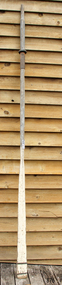 Flagstaff Hill Maritime Museum and Village
Functional object - Sculling Oar, Mid to late 19th century
An oar is an implement used for water-borne propulsion. Oars have a flat blade at one end. Rowers grasp the oar at the other end. The difference between oars and paddles is that oars are used exclusively for rowing. In rowing the oar is connected to the vessel by means of a pivot point for the oar, either an oarlock, or a hole. The oar is placed in the pivot point with a short portion inside the vessel, and a much larger portion outside. The rower pulls on the short end of the oar, while the long end is in the water. By contrast, paddles, are held in both hands by the paddler, and are not attached to the vessel. Rowers generally face the stern of the vessel, reach towards the stern, and insert the blade of their oar in the water. As they lean back, towards the vessel's bow, the blade of their oars pivots in the oarlock, and the end in the water moves towards the stern, providing forward thrust. There also is another way of propelling a small craft it's called a sculling oar which is attached to the transom and used to propel a small vessels rather than using two oars as previously described. It is believed the subject item is just such an oar given it’s long blade associated with a sculling oar. For thousands of years vessels were powered either by sails, or by the mechanical work of rowers, or by paddlers. Some ancient vessels were propelled by both oars and sail, depending on the speed and direction of the wind. Wooden oars, with canoe-shaped pottery, dating from 5000–4500 BC have been discovered in a Hemudu culture site at Yuyao, Zhejiang, in modern China. The history of man using wooden oars to propel a boat has a considerable record in marine archaeology going back many centuries. The item is significant for marine archaeology as it gives a snapshot into how a small row boat was powered using a wooden sculling oar. A method of propelling a small boat still used today an example is the gondoliers in Venice using a sculling oar in a circular motion to propel his craft. Single sculling oar with long flat blade, two copper bands, on blade with rowlock fittingNoneflagstaff hill, warrnambool, flagstaff-hill, flagstaff-hill-maritime-museum, maritime-museum, shipwreck-coast, flagstaff-hill-maritime-village, boat oar, sculling oar, row boat -
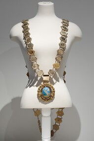 Bayside Gallery - Bayside City Council Art & Heritage Collection
Ceremonial object - Mayoral chain, Lega, City of Brighton Mayoral Chain, 1953
This chain was part of the official regalia worn by the Mayor of the City of Brighton before the amalgamation into Bayside City Council in 1994. The chain was seen as an outward sign of power, authority, and responsibility and was a formal, full-dress type of regalia that was worn by the mayor over their robes at ceremonial functions. The large central drop medallion featured the design of the council seal and the links of the chains detail the name and date of each appointed Mayor. This council seal features the Brighton coastline with a pier extending to the water, a sail boat in the distance and a train on the right of the pier. It was displayed by Council on its flag and letterhead and in municipal buildings and can still be seen on the portico of Brighton Town Hall. The seal was used from 1919, when Brighton was declared a city, until 1970, when an official crest was issued by the British College of Heraldry. Brighton was first incorporated as a borough on 18 January 1859, it became a town on 18 March 1887 and was proclaimed a city on 12 March 1919.9 carat yellow gold and enamel mayoral chain for the City of Brighton. Consists of 61 small oval links, with a scroll listing significant dates in Brighton's history as a centrepiece and a large 'drop' medallion of the City of Brighton seal below. Each oval link has a central plaque inscribed with a mayor's name and dates of their office surrounded by a thin coiled edge and a thick decorative border. The earliest Mayor is W.P. Francis 1918-19 and the latest is K.D. Oliver 1994-95. The links are joined by cable chain and form a long circular chain with two crosspieces of additional links at the back, the upper crosspiece contains four links, while the lower piece contains three links. The chain has a large oval medallion/pendant of the City of Brighton seal which is surrounded by a thin coiled gold edge, a border containing raised lettering 'CITY OF BRIGHTON' above and a Coat of Arms below. This is also surrounded by a coiled edge. The oval piece is then wrapped around with a thick laurel wreath with small berries. The central part of the medallion contains a coloured enamel image of the Brighton coastline with sand in the foreground, a pier extending out into the water, a sailboat in the distance and a train on the right of the pier. The small Royal Coat of Arms of the United Kingdom below includes a coloured enamel shield flanked by a lion and unicorn with a motto inscribed on a ribbon underneath 'DIEU ET MON DROIT'.mayoral chain, city of brighton, lega, ceremonial wear, seal, medallion, mayor, coat of arms, crest, bayside, mayoral regalia -
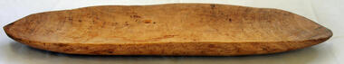 Orbost & District Historical Society
pitchi
A coolamon is an Indigenous Australian carrying vessel. It is a multi-purpose shallow vessel, or dish with curved sides, ranging in length from 30–70 cm, and similar in shape to a canoe. Coolamons or pitchis were traditionally used by Aboriginal women to carry water, fruits, nuts, as well as to cradle babies. The necessary tools and equipment for hunting, fishing and warfare were one of the very few items that Aboriginals carried with them from place to place. Most were used for a multiplicity of purposes. Because many were made from raw natural materials, such as wood, generally only partial remains are found today. This container is an example of an implement used by the early Indigenous people of Eastern Australia.A large shallow elongated hand-made wooden receptacle used by Australian aborigines as a container for food and drink or for carrying babies.pitchi coolamon aboriginal container -
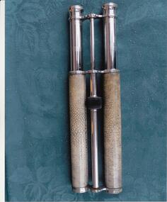 Phillip Island and District Historical Society Inc.
Photographs, Fuji Film, Twin Telescopes, 2013
Twin Telescopes - "Lemair Paris" - believed to be owned by Charles Grayden c 1870's. Traded to english settlers for cannon balls used as ballast in his boat he rowed passengers across the Eastern Passage. He may have had the first water taxi license in Victoria.283-01 and 02. Coloured photographs of twin telescopes, one with carrying bag.telescope, twin telescope, charles grayden, lloyd john grayden