Showing 42162 items matching "were"
-
 Kew Historical Society Inc
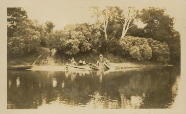
Photograph - Victorian Canoe Club, Camp site near Burke Road, 1920-30
Canoeing on the River Yarra at Melbourne was an important and widespread recreational pursuit for Melbournians, especially in the first half of the twentieth century. The Victorian Canoe Club was formed in 1912 at a meeting in Melbourne and its first committee elected in the same year. Records indicate that the Club continued into at least the 1950s .The album has historic and social significance as a record of recreational activities (as well as canoe making) in the early years of the twentieth century. It has local significance as the site of the headquarters of the Club was in Studley Park. A number of photographs in the album provide vistas of Kew on the Yarra that are otherwise unavailable.One of 24 labelled photos in part album, originating from the Victorian Canoe Club, which had its headquarters in Studley Park, Kew. The album includes a photographic record of canoe construction and also locations in Studley Park and Kew where the canoes were used. The subject of this photograph is identified as 'Camp site near Burke Road' with four canoes on the river bank with members beside them. "Camp site near Bourke Rd"victorian canoe club, river yarra, canoe clubs, canoeing, recreation -- canoeing, burke road -- kew (vic.), kew -
 Kew Historical Society Inc
Photograph, The "Q" Theatre Guild, The Bohemian Girl, 1959
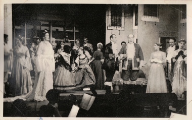
The "Q" Theatre Guild was formed out of the Kew Light Opera Company in 1957. It marked the transition of the company that had initially been directed by Lance Nicholls to one directed by Beatrice Oakley. It continued to perform in the Kew Recreation Hall, but, with its demolition in 1960, and the opening of the new Kew City Hall in Cotham Road, moved its productions to that venue. Productions of the "Q" Theatre Guild included The Geisha (1957), Maritana (1958), They All Do It (1959), Blossom Time (1959), Love's A Luxury (1959), There And Back & The Bohemian Girl (1960), Die Fledermaus (1960), Gay Rosalinda (1961), The Land Of Smiles (1961), Kisses For A Kid & Hansel And Gretel (1961), Die Fledermaus (1962), Monsieur Beaucaire (1964), Macbeath or The Beggar's Opera, and So To Bed.The scrapbook of annotated photographs, programmes, and newspaper reviews of which this item is a part was assembled by Marion Tilley, wardrobe mistress for, and performer in, productions by the Kew Light Opera Company and the "Q" Theatre Guild. It is significant as a remarkably complete document of theatre performances in Kew, Victoria during the 1950s and 1960s. The scrapbook, and the items individually catalogued within it, have artistic and aesthetic significance within the history of performing arts in Victoria in the middle of the 20th Century. They have social significance in that they reveal socio-cultural values and preoccupations during the period. The records also act as a history of arts activities in the Kew Recreation Hall and later in the Kew City Hall as entertainment and community arts and music precincts.Black and white photograph of Val Breen and members of the cast of the "Q" Theatre Guild production of Michael Balfe's The Bohemian Girl in 1959. Beatrice Oakley was the producer and John Trotter the musical director. The costumes were designed and made by Marion Tilley while the scenery was designed by Claude Ward and Lachlan Stebbins. An annotation, in the corresponding programme, records that Joan Carden (later a star of the Australian Opera) performed in the Ladies of the Chorus.Marion Tilley, the creator of the scrapbook, wrote the following underneath the photograph: "Val Breen in my wedding dress".performing arts -- kew (vic.), scrapbooks, marion tilley collection, 'q' theatre guild, kew light opera company, kew recreation hall, musical comedy -- melbourne -- victoria -
 Kew Historical Society Inc
Photograph, The "Q" Theatre Guild, The Bohemian Girl, 1959
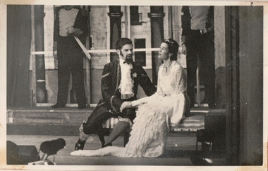
The "Q" Theatre Guild was formed out of the Kew Light Opera Company in 1957. It marked the transition of the company that had initially been directed by Lance Nicholls to one directed by Beatrice Oakley. It continued to perform in the Kew Recreation Hall, but, with its demolition in 1960, and the opening of the new Kew City Hall in Cotham Road, moved its productions to that venue. Productions of the "Q" Theatre Guild included The Geisha (1957), Maritana (1958), They All Do It (1959), Blossom Time (1959), Love's A Luxury (1959), There And Back & The Bohemian Girl (1960), Die Fledermaus (1960), Gay Rosalinda (1961), The Land Of Smiles (1961), Kisses For A Kid & Hansel And Gretel (1961), Die Fledermaus (1962), Monsieur Beaucaire (1964), Macbeath or The Beggar's Opera, and So To Bed.The scrapbook of annotated photographs, programmes, and newspaper reviews of which this item is a part was assembled by Marion Tilley, wardrobe mistress for, and performer in, productions by the Kew Light Opera Company and the "Q" Theatre Guild. It is significant as a remarkably complete document of theatre performances in Kew, Victoria during the 1950s and 1960s. The scrapbook, and the items individually catalogued within it, have artistic and aesthetic significance within the history of performing arts in Victoria in the middle of the 20th Century. They have social significance in that they reveal socio-cultural values and preoccupations during the period. The records also act as a history of arts activities in the Kew Recreation Hall and later in the Kew City Hall as entertainment and community arts and music precincts.Black and white photograph of Val Breen and Alan Wilson in the "Q" Theatre Guild production of Michael Balfe's The Bohemian Girl in 1959. Beatrice Oakley was the producer and John Trotter the musical director. The costumes were designed and made by Marion Tilley while the scenery was designed by Claude Ward and Lachlan Stebbins. An annotation, in the corresponding programme, records that Joan Carden (later a star of the Australian Opera) performed in the Ladies of the Chorus.Marion Tilley, the creator of the scrapbook, wrote the following underneath the photograph: "Val Breen in my wedding dress".performing arts -- kew (vic.), scrapbooks, marion tilley collection, 'q' theatre guild, kew recreation hall, musical comedy -- melbourne -- victoria -
 Kew Historical Society Inc
Programme, Kew Light Opera Company, The Maid of the Mountains, 1956
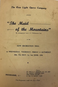
The Kew Light Opera Company was formed in 1952, and mounted a number of musical and variety productions each year until it was subsumed in the "Q" Theatre Guild in 1957. Most of the Company's performances took place in the Kew Recreation Hall in Wellington Street, Kew. A list of its productions by year includes: 1952 Florodora 1953 The Cingalee 1953 San Toy OR The Emperor’s Own 1953 Celebratory variety performance 195? While the Sun Shines 1954 A Country Girl 1954 Our Miss Gibbs 1955 The Toreador 1955 The Arcadians 1956 The Maid of the Mountains 1956 Whiteoaks 1956 Good night Vienna! 1957 A Country GirlThe Marion Tilley scrapbook is a significant record of performing arts in Melbourne during the 1950s and 1960s. The scrapbook includes programmes, photographs, newspaper reports and personal annotations which are a rich source of detail about repertoire, performers, and artistic sensibility in the period.Souvenir programme isued by the Kew Light Opera Company for a performance of 'Maid of the Mountains' by Harold Fraser-Simson. Performances were held in the Kew Recreation Hall on 30 & 31 May, and 1 & 2 June 1956. The interior of the programme includes a number of signatures of the cast. The programme forms part of a scrapbook that includes programmes, photographs and theatre reviews for the Kew Light Opera Company and later "Q" Theatre Guild.theatre (kew), performing arts, kew recreation hall, kew light opera company, maid of the mountains -
 Kew Historical Society Inc
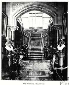
Photograph, The Vestibule, 'Goathland', 1901-1911
'Lost Glories: a memorial to forgotten Australian buildings' was published by David Latta in 1986. It tells the story of a number of significant Australian buildings that had previously been demolished. A chapter in the book was devoted to Goathland, later known as Tara Hall. To supplement the text, he sourced photographs from a range of suppliers, chiefly the Royal Women's Hospital which had once owned Tara Hall, but had sold it in 1960. This is one of the photographs donated to KHS by the author.The Vestibule, Goathland', 1901-11. The vestibule of Tara Hall (originally Byram, and later Goathland and Lowan). The vestibule was entered through a porte-cochère on the east side of the house. Visitors entered the mansion through the vestibule before progressing to the main hallway. The main rooms of the house were accessed through the latter on the ground and first floor. The photograph gives some idea of the decorative style of furnishings during this era. The Vestibule - "Goathland"byram, goathland, tara hall, lowan, studley park (kew), george ramsden, sir malcolm mceacharn, edward george kilburn (architect), studley park road (kew) -
 8th/13th Victorian Mounted Rifles Regimental Collection
Photograph
Cambrai Day is celebrated annually by Armoured Corps regiments of the British Commonwealth. It marks the anniversary of the Battle of Cambrai in November 1917 when a force of more than 400 British Mark IV Tanks broke the defences of the German Hindenburg Line, It was the first large-scale, effective use of tanks in warfare. Cambrai turned from a battle of great success to failure, but it heralded a new type of warfare and changed the nature of the battlefield forever The gathering at Buna Barracks Albury, Beersheba Barracks Wangaratta, Bapaume Barracks Benalla and Salamaua Barracks Cobram on 30 November 1986 was the inaugural meeting of the 8th/13th Victorian Mounted Rifles Regimental Association..Colour photograph of seven men taken at Buna Barracks, Albury on Cambrai Day 20 November 1986. Back row, left to right: Lieutenant Colonel Doug Hunter, Major Ian Docking, Max Oates and Gordon Cole: Front Row : Major Reg McDermot, Lieutenant Colonels Alan Cunningham and John Neale. All were former Officers of 8/13 Victorian Mounted Rifles Regiment. -
 Federation University Art Collection
Painting - Gouache, Albino Paganetti, 'Journal of Agriculture', c1935
Albino PAGANETTI (1915-1974) Born Victoria. This work won Albino Elvezio (Albert) Paganetti won third place in the Department of Agriculture’s poster competition for their official journal in 1937. The previous year, he took home several prizes at the Wiltshire Poster Contest, including first for ‘Bryant and May’; first for ‘Healing’s Batteries’, and second for the Royal Melbourne Show. A MacRobertson prize-winner, when Paganetti, completed his commercial art course at the Ballarat Technical Art School, he accepted a design position at Morshead and Co., Ballarat. Albert’s farming family lived at Italian Hill, near Daylesford, where his father was a vigneron. This item is part of the Federation University Art Collection. The Art Collection features over 2000 works and was listed as a 'Ballarat Treasure' in 2007.commercial artFramed original poster, gouache on paper, c1935 In the 1936 Ballarat School of Mines Annual Report it was stated: "It is my pleasure to report a most successful year in the Technical Art School. I the Annual Poster Competition for Technical Schools, organised by Wiltshires Pty Limited, 16 prized valued at 33 pounds 8 shillings - out of 23 prizes valued at 56 pounds - were won by our students.art, artwork, paganetti, poster, ballarat technical art school, farmer, jourmal -
 Wodonga & District Historical Society Inc
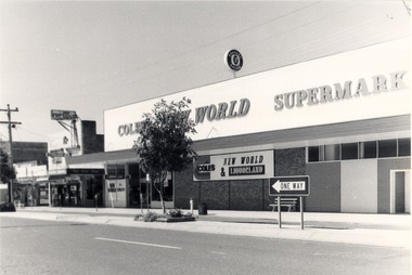
Photograph - Codling Collection 01 - High Street East - Coles Supermarket, 1980s
Miss Olive Codling was a Foundation Member and a Life Member of the Wodonga Historical Society. Many of her prize-winning photos are held in the Society Collection. She also held a range of roles and committee positions in a wide range of Wodonga community organisations. These included the Horticultural Society, the Wodonga Arts Council, the Wodonga Camera Club and the Wodonga Lapidary Club. This photo collection is significant as it documents how the businesses and buildings in Wodonga have evolved and contributed to community throughout the 20th century.Eastern side of High Street, Wodonga - Coles New World Supermarket opened on Wednesday 18th August 1971. The One Way sign was for drivers coming from Stanley Street. Parking meters were introduced in High Street in 1977 and remained until 1996. Arch Sloman was the first Manager. This location had earlier been occupied by Stiff and Gannon which was demolished to make way for the new supermarket.wodonga businesses, high st wodonga, susan hines, s & e rendich -
 Bendigo Historical Society Inc.
Newspaper - JENNY FOLEY COLLECTION: PREMIERS
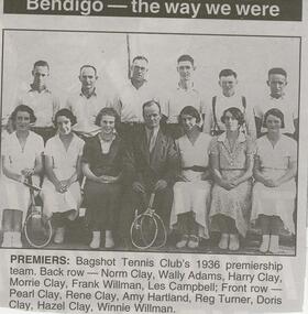
BHS CollectionBendigo Advertiser '' The way we were'' from Thursday, February 26, 2004. Premiers: Bagshot Tennis Club's 1936 premiership team. Back row: Norm Clay, Wally Adams, Harry Clay, Morrie Clay, Frank Willman, Les Campbell. Front row: Pearl Clay, Rene Clay, Amy Hartland, Reg Turner, Doris Clay, Hazel Clay, Winnie Willman. The clip is in a folder.newspaper, bendigo advertiser, the way we were -
 Bendigo Historical Society Inc.
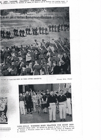
Photograph - LONG GULLY HISTORY GROUP COLLECTION: LONG GULLY WINNERS HOSE PRACTICE FOR EIGHT MEN
Copy of two fire brigade photos. The top one shows the Review in the Upper Reserve with the band in the foreground and the brigade teams marching on the reserve. The lower photos Long Gully, Winners Hose Practice for Eight Men. Team members are: B Mitchell, T Smith, G Hall, W Wearne, W Trahair, J Waterson, A Polglaise and A Truscott. Photographers were Vincent Kelly and W H Robinson.bendigo, history, long gully history group, the long gully history group - brigade review and long gully winners hose practice for eight men, w tibbett, f arthur, w stewart, e miller, h harvey, h derham, w h robinson, vincent kelly, b mitchell, t smith, g hall, w wearne, w trahair, j waterson, a polglaise, a truscott -
 Northern District School of Nursing. Managed by Bendigo Historical Society Inc.
Document - NDSN newspaper cutting
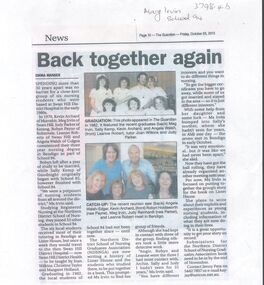
The Northern District School of Nursing opened in 1950 in to address the issues around nurse recruitment, training and education that had previously been hospital based. The residential school was to provide theoretical and in-house education and practical training over three years. The students would also receive practical hands-on training in the wards of associated hospitals. The Northern District School of Nursing operated from Lister House, Rowan Street, Bendigo. It was the first independent school of nursing in Victoria and continued until it closed in 1989. The book "The First of its Kind" was published in 2015. Printed in Bendigo by "Bendigo Modern Press". Memories compiled by Peter Rosewall; who attended the last NDSN school PTS 108 between 1986 - 89.Newspaper article from page 10 of the Guardian, Friday 25th October 2013, showing two photographs of the same group of nurses from 1982 when they had just graduated and again in 2013. They began nursing training in 1979 School 94. They trained at Lister House. The article discussed the collecting of submissions for former nurses of Northern District School of Nursing for a book they were going to produce about NDSN. nursing, at lister house., school 94 -
 Bendigo Historical Society Inc.
Newspaper - JENNY FOLEY COLLECTION: BATTER UP
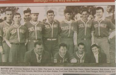
BHS CollectionBendigo Advertiser ''The way we were'' from 2002. Batter up: Cyclones Baseball Club in 1954. The team is, from left, back row: Ray Pitson, Eddie Cameron, Bob Kronk, John Fawcett, Ian Balnaves, Don Roberts, Mal Dillon and Allan Anstee. Front row: Richie Lee (coach), Basil Hedges, Norm Lindrea and Helen Hart (scorer). The clip is in a folder.newspaper, bendigo advertiser, the way we were -
 Federation University Historical Collection
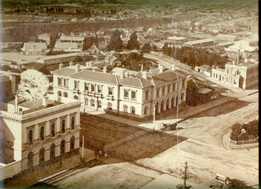
Photograph - Photograph - Black and White, Ballarat Post Office from the Ballarat Town Hall Tower, 1872, 1872
This photograph was taken from the newly completed tower of the Ballarat Town Hall. Further details on the photographer, William H. Bardwell, can be found at http://bih.ballarat.edu.au/index.php/William_H._Bardwell Framed Black and White photograph showing Ballarat from the Ballarat Town Hall. The photo shows the intersection of Sturt Street and Lydiard Street, and is taken in the direction of the Ballarat Post Office. It shows the Ballarat Railway line in the background, and the Burke and Wills Memorial Fountain in the foreground on the right.. The Ballarat Post Office is located in the centre of this photograph. There is no tower on the Post Office. The tower and other extensions were built in 1879.ballarat post office, sturt street, camp street, ballarat townscape, william bardwell, fotobiennale, arts academy, art academy, lydiard street, ballarat, william h. bardwell -
 Bendigo Historical Society Inc.
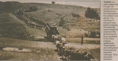
Newspaper - JENNY FOLEY COLLECTION: TOUGH
BHS CollectionBendigo Advertiser ''The way we were'' from Monday, June 3, 2002. Tough: our early settlers did it tough. All goods had to be carried to and from the ports to the settlers' new abode. The mainstay of transport was bullock wagons. The bullocky was as tough as anyone in the pioneering era and a godsend to the many outlying settlements. These teams are carting wool to be sold and exported overseas. Time and place unknown. The clip is In a folder.newspaper, bendigo advertiser, the way we were -
 Linton and District Historical Society Inc
Receipt, Invoice for Medical Services, 1944
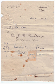
Photocopy of account/receipt for professional services and medicine provided to "Mrs Sandow" from Dr J. B. Donaldson, Jnr., who was then practising at Skipton. Services were provided between 1943 and 1944, costs amounted to a total of two pounds and seventeen shillings. The account is marked "Paid" and has a Victorian Stamp Duty stamp attached. Dr Donaldson's signature is written across the stamp, with the date 30.6.44.medical services, invoices, receipts, dr j. b. donaldson, sandow family -
 Bendigo Historical Society Inc.
Document - MISS G ALICE JONES COLLECTION: ACCOUNT
New Oswald Gold Mining Company N. L. to Miss G. Alice Jones. Pink paper dated from Oct 9 to Dec 1, 1924, and 23/1/1925. Paper details work and costs for agreement with Oswald Gold Mines N. L., the formation and registration of company, and fees which were paid. Total cost £32.19.9. R315 Delivered HCW 23/1/25.miss g alice jones - solicitor - account, new oswald gold mining company n l, oswald gold mines n l, mr stanistreet, mr mceachharn, faulkiners, gov gazette, bendigo advertiser -
 Bendigo Historical Society Inc.
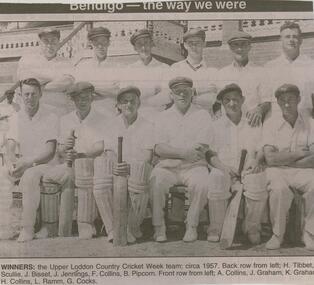
Newspaper - JENNY FOLEY COLLECTION: WINNERS
BHS CollectionBendigo Advertiser ''The way we were'' from 2003. Winners: the Upper Loddon Country Cricket week team, circa 1957. Back row from left: H. Tibbet,. Scullie, J. Bisset, J. Jennings, F. Collins, B. Pipcorn. Front row from left: A. Collins, J. Graham, K. Graham, H. Collins, L. Ramm, G. Cocks. The clip is in a folder.newspaper, bendigo advertiser, the way we were -
 Bendigo Historical Society Inc.
Newspaper - JENNY FOLEY COLLECTION: TENNIS
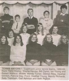
BHS CollectionBendigo Advertiser '' the way we were'' from 2003: Tennis anyone?: Eaglehawk junior tennis teams, 1968-69. Back: Terry Hopley, Wayne Harvey, Bill Clymo, Ian Young and Robert Wallace. Middle: Mandy Turner, Glenys Riley, Heather Grinton, Patricia Day. Front: heather Young, Mandy Richards, Sally Trembath, Gail Ashman and Beth Rigbye. The clip is in a folder.newspaper, bendigo advertiser, the way we were -
 Melbourne Tram Museum
Ephemera - Badge/s, Badge Minit, "Keep the Sydney Road Trams", late 1980's
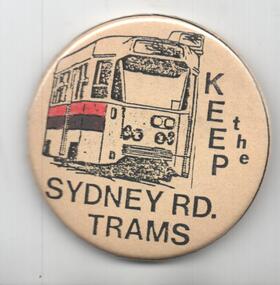
Badge - featuring the front of a Z class tram with the words "Keep the Sydney Road Trams". Has a pin with a white plastic backing on the rear to enable to be fixed to an item of clothing. Has manufacturer's name and logo on the rear of badge - Badge Minit. Advised by Neil Elphick 23/6/2018 that they were made at the time by Sydney Road traders when the Upfield Light rail was being considered 1988/1989.trams, tramways, the met, conductors, melbourne, badges, sydney rd, upfield light rail -
 Melbourne Tram Museum
Newspaper, The Herald, "Jail protesters paint trams", 23/02/1972 12:00:00 AM
Newspaper clipping titled - “Jail protesters paint trams” The Herald, Wednesday, Feb 23, 1972 Photos and text of vandalised trams at Preston workshops 20 trams, 40 men worked for an hour to remove the signs - graffiti - . Tram services not affected. Most of the trams were at Preston for repair after flood damage last week. See TMSV Running Journal April 1972 for details of the event.trams, tramways, preston workshops, graffiti, pentridge prison, protest -
 Melbourne Tram Museum
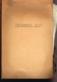
Document - Personal Papers, Melbourne & Metropolitan Tramways Board (MMTB), "Tramway Acts", 1945 to 1954
Brown coloured file folder marked "Tramway Acts" containing hand written and type written notes on the various MMTB Acts, generally c1945 to 1948 - multiple copies of the same document involving Land Acquisition, Appeals Board, powers under the Act, WW2 National Security Act (under which the Essendon Airport and Maribyrnong or Munitions tramways were built) repeal, buses, and orders in council.trams, tramways, mmtb, acts of parliament, world war 2, appeals, unions, essendon airport, west maribyrnong, munitions factory -
 Melbourne Tram Museum
Slide, Keith Caldwell, 19/03/1966 12:00:00 AM
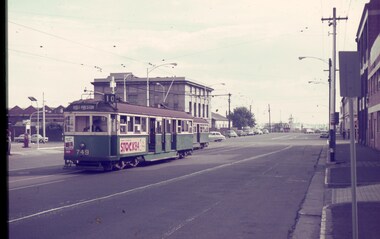
Agfa colour blue white plastic mount, photo by Keith Caldwell of W5 749 at the corner of Spencer St and La Trobe St. Tram 749, showing route 10, West Preston, with Stock84 and UniRoyal tyres. The driver is looking back through the small hole waiting for the conductor to give the starting signal. In the background is another tram and the Victorian Railways buildings that were on the corner. 19/3/1966In ink "19 iii 66"trams, tramways, w5 class, la trobe st, spencer st, west preston, route 10, drivers, conductors, tram 749 -
 Bendigo Historical Society Inc.
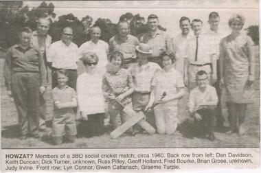
Newspaper - JENNY FOLEY COLLECTION: HOWZAT?
BHS CollectionBendigo Advertiser ''The way we were'' from Monday. May 26,2003. Howzat?: members of the 3BO social cricket match, circa 1960. Back row from left: Dan Davidson, Keith Duncan, Dick Turner, Unknown, Russ Pilley, Geoff Holland, Fred Bourke, Brian Grose, Unknown, Judy Irvine. Front row: Lyn Connor, Gwen Cattanach, Graeme Turpie. The clip is in a folder.newspaper, bendigo advertiser, the way we were -
 Falls Creek Historical Society
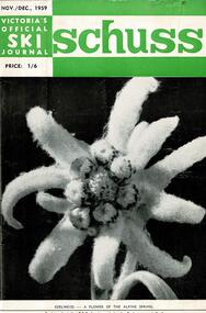
Journal - Schuss Vol. 25. No 8 November - December 1959
Schuss was advertised as Victoria’s Official Ski Journal It was issued monthly from 1935 to 1961 except during the war when summer issues covered two months. This continued after the war, but it averaged 10 issues annually over its 25 year life. Schuss was published by the Ski Club of Victoria which had a membership of 38 Ski Clubs and demanded to be recognised as the prime authority on skiing in the state. The other 30 ski clubs with 85% of the members disagreed and the politics of skiing became heated. These clubs formed the Federation of Victorian Ski Clubs with their own journal, Ski Horizon. With the establishment of the Victorian Ski Association, Ski-Horizon published its last issue in Nov - Dec. 1955 and the role of the official journal was fully taken over by “Schuss”. This item is significant because it contains stories, images and information documenting the development of the ski facilities at Falls Creek.The journal includes stories and events chronicling developments in Victoria and internationally. The cover features a photo of an Edelweiss flower. On page 292 the skiers selected for the Olympic Team to compete at the 1960 Winter Olympics were announced. Page 305 included a photo of Bob Scott of Falls Creek competing in the Downhill Championships, whilst page 309 had a short note of congratulations to Cecil Dobson and Mildred Northcote on their engagement.schuss journal, bob scott, cecil dobson -
Port Melbourne Historical & Preservation Society
Document, City of Port Phillip Annual Report Summary 95/96, 1996
Multi folded summary report on the first year of the amalgamated City of Port Phillip Council. On the 16th March 1995 voters from St Kilda, Port & South Melbourne elected the City's first council members. The elected councillors were Patricia BROWN OAM, Freda ERLICH, Dick GROSS, Christine HAAG, Liz JOHNSTONE, Ludwig STAMER and Liana THOMPSON who became the City's first Mayor.local government - city of port phillip, liana thompson, ludwig stamer, liz jonstone, christine haag, dick gross, freda erlich, patricia brown oam -
 Kew Historical Society Inc
Plan - Subdivision Plan, Erin Heights Estate, East kew, 1917
Pru Sanderson, in her groundbreaking ‘City of Kew Urban Conservation Study : Volume 2 - Development History’ (1988), summarised the periods of urban development and subdivisions of land in Kew. The periods that she identified included 1845-1880, 1880-1893, 1893-1921, 1921-1933, 1933-1943, and Post-War Development. These periods were selected as they represented periods of rapid growth or decline in urban development. An obvious starting point for Sanderson’s groupings involved population growth and the associated economic cycles. These cycles also highlighted urban expansion onto land that was predominantly rural, although in other cases it represented the decline and breakup of large estates. A number of the plans in the Kew Historical Society’s collection can also be found in other collections, such as those of the State Library of Victoria and the Boroondara Library Service. A number are however unique to the collection.The Kew Historical Society collection includes almost 100 subdivision plans pertaining to suburbs of the City of Melbourne. Most of these are of Kew, Kew East or Studley Park, although a smaller number are plans of Camberwell, Deepdene, Balwyn and Hawthorn. It is believed that the majority of the plans were gifted to the Society by persons connected with the real estate firm - J. R. Mathers and McMillan, 136 Cotham Road, Kew. The Plans in the collection are rarely in pristine form, being working plans on which the agent would write notes and record lots sold and the prices of these. The subdivision plans are historically significant examples of the growth of urban Melbourne from the beginning of the 20th Century up until the 1980s. A number of the plans are double-sided and often include a photograph on the reverse. A number of the latter are by noted photographers such as J.E. Barnes.The Erin Heights Estate in Kew included just seven lots in in Valerie Street. These were all that remained of this wartime subdivision, the other 11 allotments on Balfour and Belford Roads having already been sold. Balfour Road was to be only a temporary name as the street is currently called Windella Avenue. Now, the parkland opposite the subdivision is the reserve created from the route of the Outer Circle Railway. This Railway reached Kew East in 1925, but had been planned as far back as 1873. The development focuses on the benefits of living in Kew: being at the highest of Kew’s ‘suburbs’; being a good residential area; its rapid growth; and the proximity of the Kew East tram in High Street. In 1917, the electric tramline only extended to a terminus at the Harp of Erin hotel. The terminus is clearly represented on the plan.subdivision plans - east kew, erin heights estate -
 Phillip Island and District Historical Society Inc.
Photograph Album, Kodak, Phillip Island Cemetery, c 1990
The Album was compiled by Nancy McHaffie late 1990's, with the assistance of Edith Jeffery's, with her book "Garden of Memories" and extensive knowledge of Phillip Island. The Cemetery lies back from the road and is surrounded by Manna Gums, rare Peppermint Gums, Blackwoods and other native trees. In all 25 acres of land were set aside as Crown Land in the land settlement of 1868. There are 6.2 acres of wetlands near the cemetery entrance.466-32: Stanley Stowel Kennon Sr. was born in Melbourne in 1852. He spent many years at Newhaven and Cowes. He was 24 years old when he spent six weeks on Seal Rocks obtaining Seal Oil. In 1888 he rescued Sir William Irvine and a friend when they were marooned on a small island whilst out fishing. He was presented with a gold watch and chain for his bravery. Stanley was known as one of the most capable and daring sailors ever connected to Phillip Island. He died in 1924 aged 72. 466-33: Lucy Cox was the wife of George Cox who was the first official mailman to Phillip Island. George had a love of the sea from boyhood serving as a British Sailor. He heard of the discovery of gold in Australia which brought him to Australia to try his luck. He built a hut on the foreshore opposite the Isle of Wight Hotel. He lived there until he disappeared; it is thought he drowned. Lucy died 3rd September 1888.phillip island cemetery, nancy mchaffie, edith jeffery, george cox, lucy cox, stanley kennon -
 Bendigo Military Museum
Photograph - Army Survey Regiment - Defence Force Service Medal Presentations, Fortuna Villa, Bendigo, 1995
These nine photographs of a CO’s Parade were taken on the 6th of December 1995 at the Army Survey Regiment, Fortuna, Bendigo. On this occasion CO LTCOL Duncan Burns presented the Defence Force Service Medal to SSGT Stephen Hill OAM CSM, SGT Stuart Ridge, SGT Peter Peterson and CPL Eric Nicolson for 15 years of efficient remunerated service in the Australian Army.This is a set of nine photographs taken at the CO’s Parade at the Army Survey Regiment, Fortuna, Bendigo, on the 6th of December 1995. The photographs were printed on photographic paper and are part of the Army Survey Regiment’s Collection. The photographs were scanned at 300 dpi. .1) - Photo, black & white, 1995. RSM WO1 Ken Johnston OAM MM. .2) - Photo, black & white, 1995. L to R: CAPT Tony Harder – UK Exchange Officer, CAPT Doug Arman. .3) - Photo, colour, 1995. L to R: WO2 Paul Leskovec CSM, unidentified, WO2 Kevin Kennedy, SSGT Peter Curtis, CPL John ‘JJ’ Smith, SGT Peter Peterson, CAPT Tony Harder (foreground), unidentified, SSGT Stephen Hill OAM CSM, CAPT Doug Arman (foreground). .4) - Photo, colour, 1995. L to R: MAJ Mick Banham, RSM Ken Johnston OAM MM, CAPT Tony Harder, QM CAPT Bill Griggs, SSGT Peter Curtis CPL John ‘JJ’ Smith, unidentified, SGT Peter Peterson, ADJT CAPT Brenton McDonald, CAPT Doug Arman, SSGT Stephen Hill OAM CSM, remainder unidentified. CAPT Bin Fashar Sutimin – Indonesian Exchange Officer in dark green uniform with gold lanyard. .5) - Photo, colour, 1995. L to R: CAPT Bin Fashar Sutimin – Indonesian Exchange Officer in dark green uniform with gold lanyard, unidentified (x5) SSGT Bob Thrower, unidentified SGT Peter Tuddenham, remainder unidentified. .6) - Photo, colour, 1995. L to R: RSM Ken Johnston OAM MM, ADJT CAPT Brenton McDonald, WO2 Pat Lumsden (partially obscured), CO LTCOL Duncan Burns. Defence Force Service Medal recipient - SSGT Stephen Hill OAM CSM. .7) - Photo, colour, 1995. L to R: WO2 Pat Lumsden (partially obscured), CO LTCOL Duncan Burns. Defence Force Service Medal recipient – SGT Stuart Ridge. .8) - Photo, colour, 1995. L to R: CO LTCOL Duncan Burns. Defence Force Service Medal recipient – CPL Eric Nicolson. .9) - Photo, colour, 1995. L to R: WO2 Pat Lumsden, CO LTCOL Duncan Burns. Defence Force Service Medal recipient – SGT Peter Peterson..1P to.9P – The occasion and date are annotated on the plastic sleeve and the back of the photos.royal australian survey corps, rasvy, army survey regiment, army svy regt, fortuna, asr -
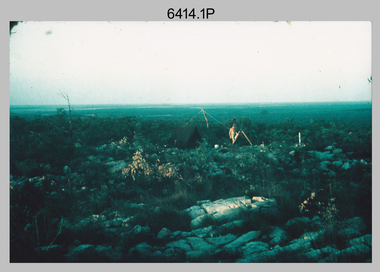 Bendigo Military Museum
Photograph - Royal Australian Survey Corps Surveyors in the Field – Northern Territory and Queensland, 1959 – 1960
This is a set of 10 photographs of surveyors and support staff in the field undertaking duties in the Northern Territory and North Queensland in 1959 – 1960. The surveyors were employed in the establishment of mapping and geodetic control. In this era surveyors used theodolites to observe horizontal and vertical angles and tellurometers to measure base line distances between survey stations. Laplace survey observations seen in Photo .1P was a series of precise observations carried out at geodetic survey stations to determine astronomic latitudes, longitudes and azimuths to achieve maximum precision in the survey network. Laplace observations were necessary in a geodetic network at every 6th survey station, however the National Mapping Council specified at this time the spacing would be ideally between 4-6 survey stations. The cairn shown in photo .4P was built by RASvy as a landmark over a trigonometric survey station. It was dismantled in 1960 to enable re-occupation and survey observations. It was not restored to the condition shown in the photo.This is a set of 10 photographs of surveyors and support staff in the field undertaking duties in the Northern Territory (NT) and Queensland (QLD) in 1959 – 1960. The photographs were printed on photographic paper and are part of the Army Survey Regiment’s Collection. The photographs were scanned at 300 dpi. .1) - Photo, colour, 1959. Tony Slattery occupying a Laplace survey station on a hill in the Mount Young area of the NT. .2) - Photo, colour, 1959. Surveyors’ camp in the Mount Young area of the NT, L to R: Spencer Snow and Tony Slattery. .3) - Photo, colour, 1959. Surveyors’ camp in the Peckman Hill area, near Katherine in the NT. .4) - Photo, colour, 1959. Cairn on Trig Hill, Borroloola, NT. Built by Spencer Snow, Tom Royle and Jack McCabe. .5) - Photo, colour, 1959. Survey party taking a break next to their Austin Champ vehicle, in transit between Katherine, NT and Wyndam WA. L to R: Tony Slattery, Dave Owens, John Van De Graff. .6) - Photo, colour, 1960. Surveyors’ camp between Mount Isa, QLD and Borroloola, NT. L to R: Pat Cox and John Van De Graff prepare their meal on an open fire. .7) - Photo, colour, 1960. Surveyor - Dennis Woods undertaking survey observations, using MRA1 tellurometer to measure base-line distances NW of Mount Isa, QLD. .8) - Photo, colour, 1960. Unidentified surveyors assessing recovery of their stalled Studebaker truck vehicle after attempting a water crossing in the NT. .9) - Photo, colour, 1960. Unidentified surveyor making batches of bread at a camp in the NT. Seen in the photo placing a lid with hot coals onto the camp oven. .10) - Photo, colour, 1960. Unidentified survey party occupying a survey station on a hill in the Mount near the Lawn Hill area, NW of Mount Isa, QLD. A MRA1 tellurometer to measure base-line distances appear on the right side of the photo. .9) - Photo, colour, 1960. Unidentified surveyors assessing recovery of their stalled Studebaker truck vehicle after attempting a water crossing in the NT. .10) - Photo, colour, 1960. Unidentified surveyor making batches of bread at a camp in the NT. Seen in the photo placing a lid with hot coals onto the camp oven. .1P to .10P annotated on back – personnel names, the year and the location. royal australian survey corps, rasvy, army survey regiment, asr, army svy regt, fortuna, surveying -
 Frankston RSL Sub Branch
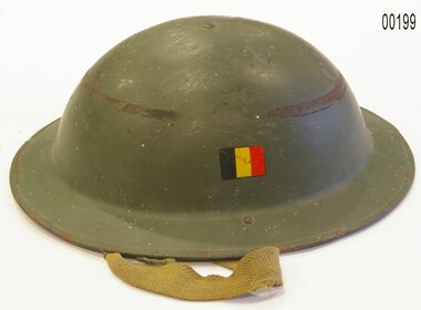
Helmet, Belgian
Mark 2 Belgian Clone of the British Brodie helmet. After the end of the Second World War Belgium began manufacturing their own version of the British Mk.II Helmet, which came to be known as the Belgian Mk.II Clone. This helmet was used by all services of the Belgian Military; Army, Navy and Air Force, as well as in Civil Defence. Mk.II Clones were produced from 1949 to 1952 and were very similar to the British Mk.II in almost every respect. However on closer inspection the differences are obvious, most noteably with the liner. Belgian Mk.IIs have a brown leather liner with five tongues and a brown drawstring. The cross shaped crown pad has black sorbo foam covered by leather. The underside of the leather has the Belgium Crest printed, while British helmets used oilcloth. Also unlike on British made Mk.IIs, the rims and lugs are made of mild (i.e. magnetic) steel. A Belgium Flag decal was worn on the left hand side of the shell, on all Military issue helmets. Stencilled on the liner is "COMET ABL 50", with the ABL (Armee Belge/Belgische Leger).