Showing 757 items
matching 'mountain road
-
 Halls Gap & Grampians Historical Society
Photograph - Transparency, C 1920s
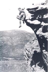
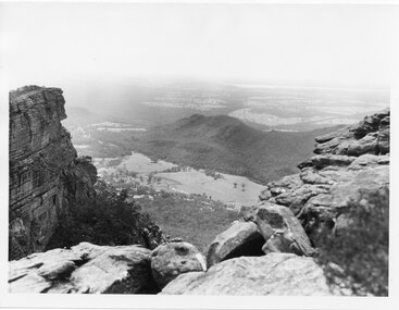
Gilbert Francis Rogers (1884-1950). Born In Gawler,S.A. came to Halls Gap as a photographer. He soon became a guide as well as a photographer, often setting up his camera and then posing in the most unusual positionsMan with wearing boots with photographic equipment set up ,balancing on a ridge of a mountain range. Mt. William Range is in the background, Fyans Valley/Halls Gap is visible below.people, gilbert rogers -
 Halls Gap & Grampians Historical Society
Postcard - B/W
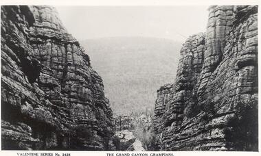
Valentine Series No.2428. Postcard of the Grand Canyon, Grampians." Valentine Publishing Co. Melbourne and Sydney" ---"Valentines Real Photo Series" on reverse of postcard.There are rocky ranges on both sides with a gap in the middle. A mountain range is in the background.scenery, grampians ranges -
 Halls Gap & Grampians Historical Society
Photograph - Sepia
"Wonderland Avenue, Grampians" printed in white on photograph.Rocky formations. Mountain range in the background. Straggly trees in foreground beside large boulders.scenery, wonderland range -
 Halls Gap & Grampians Historical Society
Postcard - B/W
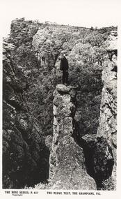
Postcard of The Nerve Test, The Grampians,Vic. ---The Rose Series,P617. Published by the Rose Stereograph Co. Armadale, VicYoung man in suit standing on an outcrop of a rocky ledge,mountain scenery in background.scenery, grampians ranges -
 Halls Gap & Grampians Historical Society
Photograph - B/W
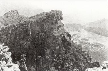
Relph Peak, named after A.U. Relph of the Government Tourist Department. See P67 of Bridging the Gap, by Ida Stanton. Steep rocky escarpment, valley down below, smaller range opposite, mountain rising higher in background.scenery, wonderland range -
 Halls Gap & Grampians Historical Society
Postcard - Coloured
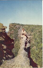
The "Nerve Test" with Bellfield Peak beyond,the Grampians, Victoria. Postcard by Nuclorvue Productions Pty. Ltd.Young man crouched on top of narrow rocky outcrop, mountains in background,steep ravines on either side.Postcard/letter no date except Tuesday,7th.scenery, grampians ranges -
 Halls Gap & Grampians Historical Society
Photograph - Sepia
Rocky mountain peak,four people on top of ridge, a mountain range in background. Three of the people appear to be wearing scout uniforms.scenery, peaks -
 Halls Gap & Grampians Historical Society
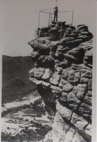
Photograph - B/W
The Pinnacle Lookout with Fyans Valley below. Bellfield Hotel is visible in the lower left of the picture, cleared land is apparent in the middle of the picture.Man standing at a lookout on a rocky outcrop overlooking a valley. Guide rails surround part of the outcop. A mountain range is opposite.scenery, lookouts -
 Halls Gap & Grampians Historical Society
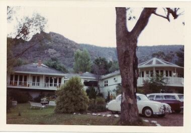
Photograph - Coloured, C early 1970s
The photo is of Mountain Grand guesthouse.Photo shows a large building with verandahs in front of the on the left and right wings. Verandah on the right is semi-circular to accommodate the design of the room behind it. A large eucalyptus tree stands in the foreground. Two cars are parked beside the tree."Kodacolor print, Kodak, April-71M" stamped on back in pink.accommodation, mountain grand -
 Halls Gap & Grampians Historical Society
Photograph - B/W
The photo is of the Fyans Valley, taken from Chatauqua Peak. Lake Bellfield and Mount William can be seen in the background. The photo belonged to the Forestry Commission Victoria.A photo of a valley between mountain ranges. A lake can be seen in the background. A road runs through the middle of the valley with houses on both sides."Fyans Vaslley from Chataqua Peak. Incl L. Bellfield & Halls Gap. photo belongs to F.C.V. Stawell. Return to V. Young, Horsham" written on back in green pencil. The "Chatauqua Peak" has been overwritten in black-lead pencil. "LC.71" is also written on the back in black-lead pencil.scenery, grampians ranges -
 Halls Gap & Grampians Historical Society
Photograph - B/W
Photo is of the "Victoria Valley" taken from around the area of Reed's Lookout. The body of water is Moora Moora Reservoir. The background range is Victoria Range. Photo is typical of promotional photos taken by Forests Commission VictoriaRocky outcrop in foreground and a large, thick tree covered valley, with mountain ranges in the background. A body of water (near top, middle) and some roads can be seen c1960sscenery, grampians ranges -
 Halls Gap & Grampians Historical Society
Photograph - B/W
Photo is of Victoria Valley with Moora Moora Reservoir and the Victoria Range in the background. Photo would have been taken from around Reed's lookout area. Photo typical of promotional photos of the time by Forests CommissionLarge, densely treed valley with a body of water in background. Some roads can be seen particularly right foreground. There is a mountain range in the background. c1960sscenery, grampians ranges -
 Halls Gap & Grampians Historical Society
Photograph - B/W
Photo is of Victoria Valley with the Victoria Range in the background. Photo is typical of promotional photographs taken by Forests Commission at that time.a thick bush covered valley in foreground (shadowed). Mountain range in background. Photographed from a high spot looking down and across the valley. c1960sscenery, grampians ranges -
 Halls Gap & Grampians Historical Society
Postcard - B/W
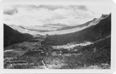
Photo on card was taken by Gilbert Rogers, a photographer and tour guide during the 1930s. This postcard is one of a series.Depicts as valley with mountains on both sides. Cleared land can be seen on either side of a road which runs through the valley. Buildings are also visible in middle area. View is running south-west.scenery, fyans valley -
 Halls Gap & Grampians Historical Society
Photograph, C 1940 -50s
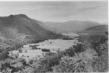
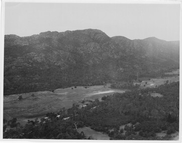
Valley is now known as Fyans Valley but in the 1840-50s it was called Lady Mary's Vale. See p. 111 of 'Victoria's Wonderland' for historical information.A valley with a cleared area stretching along the valley floor. A mountain range runs along the left and into the distance of the photograph. a rocky outcrop, bushes and trees appear in the front and right of the photo. c 1940-1950sscenery, fyans valley -
 Halls Gap & Grampians Historical Society
Photograph - B/W, C 1950s (?)
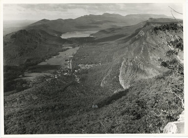
Photograph is of Fyans Valley taken from Bellfield Peak. The mountain range across the centre of the scene runs north to south. The large dwelling centre-front is Bellfield Hotel, which was destroyed by fire in the 1960s. The main road running through the middle of the valley is Grampians Road.A rocky outcrop, far right, with metal fence and posts. View of a valley with cleared land, roads and buildings in foreground. Further cleared land can be seen beyond a mountain range that is in the centre of the photograph.scenery, fyans valley -
 Halls Gap & Grampians Historical Society
Photograph
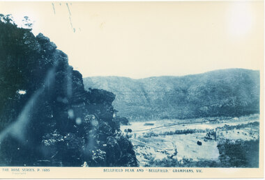
Photo is of Fyans Valley with Hotel Bellfield in the valley. Photo is taken from Bellfield Peak. c1940sA rocky outcrop on far left of photo. a cleared valley with buildings and roads in foreground, flanked by a mountain range.THE ROSE SERIES. P 1695 BELLFIELD PEAK AND "BELLFIELD," GRAMPIANS, VIC scenery, fyans valley -
 Halls Gap & Grampians Historical Society
Photograph, C 1960s
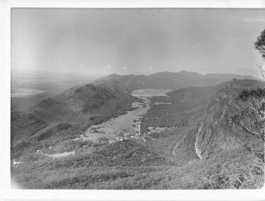
The valley is known as Fyans Valley and the township of Halls Gap. Photo is typical of those taken by the Forestry Commission (Vic) during the 1960s.Photo shows two rocky outcrops in the foreground framing a valley in the distance below. A partial view of a mountain range flanks the valley. Plains of trees and open fields, and also a lake, can be seen beyond the mountain range. Within the valley in the middle of the photo buildings, roads and cleared land can be seen.scenery, fyans valley -
 Halls Gap & Grampians Historical Society
Photograph - B/W
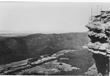
Photo has been taken from Boroka Peak/lookout, of the Fyans Valley and the township of Halls Gap. The Grampians/Dunkeld Road can be seen running North/South along the right edge of the valley and Lake Bellfield is the water at the end of the valley. Photo is typical of those taken by Forrests Commission at the timea photo of a valley, mostly cleared, flanked by two mountain ranges. A large body of water can be seen at the far end of the valley (middle of photo). Buildings and roads visible in the valley. Plains can be seen beyond the far mountain range on the left side of the scene.no.42scenery, fyans valley -
 Halls Gap & Grampians Historical Society
Photograph - B/W
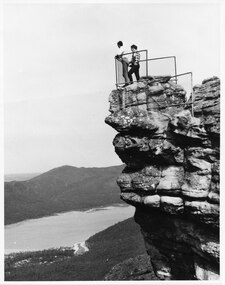
The two men are standing at The Pinnacle Lookout, overlooking Bellfield Reservoir in the Fyans ValleyTwo men standing behind cyclone wire three panel fence. Man on left is wearing a white shirt and long pants, the other in a checked shirt and long dark pants. They are on top of a large rocky outcrop overlooking a body of water and another mountain range scenery, lookouts -
 Halls Gap & Grampians Historical Society
Photograph
Photo depicts Fyans Valley. The road is The Grampians/ Dunkeld Road, leading to Dunkeld towards the right or Halls Gap travelling towards the left. Fyans Creek is visible in parts at the foot of the range (middle of Photo). Photo appears to have been taken from Bellfield Pk area. Photo is typical of those taken by Forests Commission of Victoria in the 1960sPhoto shows a mountain range in the background with a valley. The Valley has a band of a mostly cleared grassy section (middle of photo) with a fairly dense treed area in the foreground. A road and some buildings can be seen where the cleared land meets the treed area.scenery, fyans valley -
 Halls Gap & Grampians Historical Society
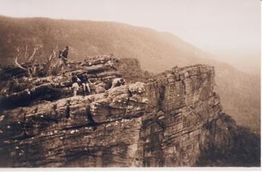
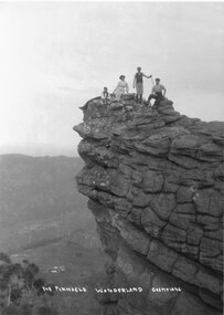
Photograph - B/W
Photograph is taken at the Pinnacle in the Wonderland Range. The valley below is the Fyans Valley.Three men and a woman laying, sitting and standing on top of a high rocky outcrop. The woman and two men wear hats and the man standing is holding a stick. A mountain range can be seen opposite them with a valley far below, between the two ranges. A group of buildings can be seen in the valley. The style of dress worn by the people suggests early 1900s.The Pinnacle Wonderland Grampiansscenery, wonderland range -
 Kiewa Valley Historical Society
Sign - Bogong State School
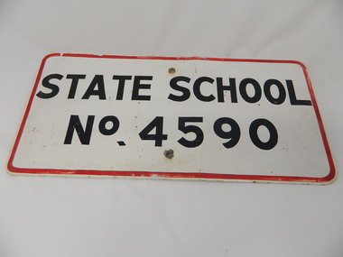
... school would have been 14 miles away and over mountain roads ...Bogong State School opened in 1941 to provide an education for the employees of the State Electricity Commission of Victoria. The school had up to date equipment and received glowing reports from School inspectors. It closed c1986.Historical: The Bogong State School was opened for the children of S.E.C.V. workers who lived at Bogong in a remote part of north east Victoria. The nearest school would have been 14 miles away and over mountain roads subject to heavy construction traffic and extremes of climatic conditions. Metal sign painted white with thin red border and black block capital letters and numbers. There is a hole in the middle top and middle bottom of the sign."State School / No. 4590"state school. bogong. education. state electricity of victoria. kiewa hydro electric scheme. -
 Kiewa Valley Historical Society
Photos - King Family Collection
The King family lived in Tawonga South where my older brother and sister went to school. We lived over the road from Wally Madison's farm. Later when a house became available, we moved into Valley Avenue, Mt Beauty. This is when I turned 5 and started my schooling. It was a long walk for a 5 year old as I remember. Then later we moved to 50 Lakeside Ave. I remember we loved living there as it was close to the school, footy ground and kindergarten. My father, Ted King, wad a carpenter and was involved in the building of many houses in Mt Beauty which was the home for the workers on the Kiewa Electric Scheme. So as they are part of the history of Mt Beauty I thought they may be useful to you as part of the history. The tennis photos, I vaguely remember Lou Hoad and Ken Rosewell giving exhibition matches in Mt Beauty. I may stand corrected on this, but I do remember my parents who were keen tennis players themselves were most excited at seeing these famous tennis players. As I was only 9 when we left Mt Beauty to live in Dimboola I still remember the shock of leaving a beautiful mountainous county side and arriving in a flat farming land next to a desert and seeing windmills One thing I do remember from school is, once a week (or fortnight) the teacher used to come around with a jar of little white pills, of which we were all to take. I really don't know what they were?? or for?? I also remember being taught to swim in the freezing cold river by a Mrs Smith who wore black bathers and wore her hair in a bun...... ...I am now in my 70s My father used to also carve intricate trays and jewellery boxes in his spare time. I think they were used for tennis trophies. by Diane Werner.x33 photos of small black and white photos of the Tawonga, Tawonga South and Mt Beauty - Photos not labelled but described as follows. See each photo for a possible label. A. Tawonga? B. Mt Beauty taken on the road to Bogong ? C. SEC Works D. Industrial buildings with mountains in the background E. Building site with wooden frame and 3 men F. Buildings with power poles G. Building site with lots of huts H. Buildings under construction I. Group of houses in the distance J. Group of houses in the distance K. Group of people in front of a building L. Group of 8 men sitting on timber planks, corrugated iron at back. M.& N. Building site with floor and upright timbers O. Mountain view with camp site in foreground P.& Q. Buiding site, several houses R.5 men at a building site S. portable building on trailer T & U. Mountain view V. Building site W. Group of men, car and mountains in background X. Cows Y. Pigs Z. 2 men standing next to cars. AA. Football players BB. Man painting a corrugated iron building CC. Football DD. Men in front of a building EE Buildings with mountains in background FF & GG Tennis payersHH & II. Electricity infrastructure -
 Kiewa Valley Historical Society
Photo - Mt Beauty c1948, Early photo of Mt Beauty Townhip c1948
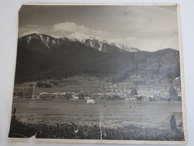
Mt Beauty was constructed by the State Electricity Commission of Victoria to house employees of the Kiewa Hydro Electric Scheme. Mt Beauty township looking south east from Hollond's property c1948. Only one transmission line has been built.In the foreground are houses in Simmond's Creek Road. Some houses in North Beauty. The town is still under construction - not all roads have been made and houses haven't any garden around them.This is an early photo of Mt Beauty during construction of the town.d It shows a few houses in Simmonds Creek Road. Large black and white photo of Mt Beauty township with snow on the mountains in the background.mt beauty township 1948, mt beauty construction, simmonds creek road -
 Kiewa Valley Historical Society
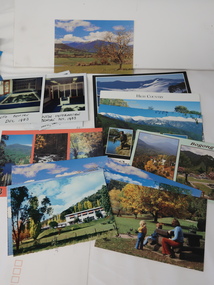
Photos, Postcards - Kiewa Valley
... not include cycling (mountain bikes and road bikes), snow boarding ...Mt Beauty township, at the head of the Kiewa Valley, is situated at the foot of Mt Bogong. The town was established by the State Electricity Commission of Victoria during the construction of the Kiewa Hydro Electric Scheme on the High Plains.Mt Beauty is a popular tourist resort. The main highway from Mt Beauty to the Bogong High Plains is most picturesque throughout the year. During the winter months, Falls Creek provides access to Falls Creek Ski Village for snow sports. Tawonga, 6.5 km north of Mt Beauty, is famed for its trout fishing and camping on the Kiewa River. Deciduous trees make a show of colour during Autumn. The postcards are of historical value showing photos taken at an earlier time.The postcards can be compared to the attractions of the time as they do not include cycling (mountain bikes and road bikes), snow boarding, gliding and paragliding. Advertising for tourism has also changed as attractions are now available on-line. 1. 9 Coloured Photos of Bogong (5) and Visitors Information Centre display (4) 2. Two fold out coloured sets of postcards "Mt Beauty and the Kiewa Scheme", "Mt. Beauty Victoria" 3. x10 Coloured postcards Mt Beauty, Kiewa Valley, Bogong 4. x6 Coloured postcards High Country and Bogong Villagepostcards kiewa valley -
 Eltham District Historical Society Inc
Newsclipping photocopies, Holdup of Commercial Bank, Main Road, Eltham
Articles cover the story of an attempted bank robbery of the Commercial Bank, (Main Road, Eltham) on Thursday 15th December 1949 when shots were exchanged in a bid to prevent the escape of a man who had attempted to rob the bank. A subsequent search took place. 19 year old youth Kay Arthur Morgan was later caught and committed to trial. He had used a stolen gun, 15 shots had been fired.. Two bullets were fired into the ceiling and back wall of the bank, after penetrating the wooden counter and passing in between the legs of the receiving officer Spear. Names mentioned: Senior Constable N. Forbes, Harry Wallace (Manager), Mr. L.A. Spears (Receiving Officer) , Senior Detective H. McMennamin, Mr H. D. Pettie (Mountain View Rd, Montmorency, Detective Sergeant K. Hubbard, Inspector F. Hobley, Senior Inspector R. Newton, Detective P. Pedersen, Detective L Dent, Detective J. Oakers, Includes photosFour pages of photocopies of newspaper clippings with typed source information. Pistol stolen, The Argus, 10th December, 1919 Search of Scrub proves fruitless, The Age 17th December 1949, page 3 Pistol Battle at Bank, The Age 16th December 1949 "Guilty" pleas to pistol theft Court told of lad's hold-up bid, The Argus 23rd February, 1950 page 7 commercial bank, eltham, robbery -
 Eltham District Historical Society Inc
Negative - Photograph, Timber Tramway at Wright's Falls, Kinglake District, c.1920
Man and woman stand beside timber tramway track at Wright's falls Kinglake. The tramway was constructed alongside the road to support the large traffic in firewood between the mountains to Whittlesea. The Wright family owned the land on which the Falls were situated and were sold for a penny an acre according to a Wright family story. This photo forms part of a collection of photographs gathered by the Shire of Eltham for their centenary project book,"Pioneers and Painters: 100 years of the Shire of Eltham" by Alan Marshall (1971). The collection of over 500 images is held in partnership between Eltham District Historical Society and Yarra Plenty Regional Library (Eltham Library) and is now formally known as 'The Shire of Eltham Pioneers Photograph Collection.' It is significant in being the first community sourced collection representing the places and people of the Shire's first one hundred years.Digital image 4 x 5 inch B&W Negshire of eltham pioneers photograph collection, kinglake, timber tramway, wrights falls -
 Orbost & District Historical Society
programs, 1961
The Snowy River Shire was a local government area in the Australian Alps region of New South Wales, Australia from 1939 until May 2016. It was named after the Snowy River that runs through it. Prior to 1936, it had been named as Dalgety Shire since establishment in 1906. This opening of the Monaro - Gippsland Road took place on 4th May 1961. There had long been a movement in Monaro for the construction of a road to connect Monaro and Gippsland, via Inglebyra and Black Mountain. The only track was for stock, made by pioneers many years ago, and it was very circuitous. It was stated at a meeting at Dalgety that the road would open up large areas for settlement for grazing, and for timber suitable for bridgé building. The road would assist stock deal ing between Monaro and Gippsland. It would also considerably shorten the distance from Victoria for tourists visiting Canberra and Kosciusko. A committee was formed to put the proposal before the Dalgety Shire Council in the 1930s.This item is a useful research tool.Four copies of a road opening program. It has black print on white. There are black / white photographs, historical details and details of the official opening.program monaro-road snowy-river-shire -
Ringwood and District Historical Society
Memorial prize presentation box, Presentation box of the Ringwood Mountain District Sports Association with six small metal plaques for the years 1936-1944, 1936 -1944
Presentation box of the Ringwood Mountain District Sports Association (RMDSA) The badges are for RMDSA Premiers 1936 Rounders RMDSA Football Ringwood East Premiers Section A 1938 RMDSA Premiers Rounders 1940 Ringwood East . Also 1941 Section A Ringwood East and 1944 .Box of fiddleback wood with glass front. Along lower edge and right hand side front six metal badges for sporting achievements of the Ringwood Mountain District Sports Association. Four shield shaped and two rectangular badges. Years 1936 -1944