Showing 787 items
matching brighton road.
-
 Glen Eira City Council History and Heritage Collection
Document (Item) - Newspaper (digital), Glen Eira News, 2009
The Glen Eira news is the official newspaper of the City of Glen Eira from 1995 to present day. The City of Glen Eira is the Municipal Council for an area of the South Eastern suburbs of Melbourne, including Bentleigh, Bentleigh East, Brighton East, Carnegie, Caulfield, Elsternwick, Gardenvale, Glen Huntly, McKinnon, Murrumbeena, Ormond and St Kilda East. Prior to the amalgamation of City of Caulfield and parts of the City of Moorabbin in 1994, the Glen Eira News was preceded by the Caulfield Contact Monthly. glen eira, city of glen eira, bentleigh, bentleigh east, brighton east, carnegie, caulfield, elsternwick, gardenvale, glen huntly, mckinnon, murrumbeena, ormond, st kilda east -
Glen Eira City Council History and Heritage Collection
Document (Item) - Newspaper (digital), Glen Eira News, 2010
The Glen Eira news is the official newspaper of the City of Glen Eira from 1995 to present day. The City of Glen Eira is the Municipal Council for an area of the South Eastern suburbs of Melbourne, including Bentleigh, Bentleigh East, Brighton East, Carnegie, Caulfield, Elsternwick, Gardenvale, Glen Huntly, McKinnon, Murrumbeena, Ormond and St Kilda East. Prior to the amalgamation of City of Caulfield and parts of the City of Moorabbin in 1994, the Glen Eira News was preceded by the Caulfield Contact Monthly. glen eira, city of glen eira, bentleigh, bentleigh east, brighton east, carnegie, caulfield, elsternwick, gardenvale, glen huntly, mckinnon, murrumbeena, ormond, st kilda east -
Glen Eira City Council History and Heritage Collection
Document (Item) - Newspaper (digital), Glen Eira News, 2011
The Glen Eira news is the official newspaper of the City of Glen Eira from 1995 to present day. The City of Glen Eira is the Municipal Council for an area of the South Eastern suburbs of Melbourne, including Bentleigh, Bentleigh East, Brighton East, Carnegie, Caulfield, Elsternwick, Gardenvale, Glen Huntly, McKinnon, Murrumbeena, Ormond and St Kilda East. Prior to the amalgamation of City of Caulfield and parts of the City of Moorabbin in 1994, the Glen Eira News was preceded by the Caulfield Contact Monthly. glen eira, city of glen eira, bentleigh, bentleigh east, brighton east, carnegie, caulfield, elsternwick, gardenvale, glen huntly, mckinnon, murrumbeena, ormond, st kilda east -
Glen Eira City Council History and Heritage Collection
Document (Item) - Newspaper (digital), Glen Eira News, 2012
The Glen Eira news is the official newspaper of the City of Glen Eira from 1995 to present day. The City of Glen Eira is the Municipal Council for an area of the South Eastern suburbs of Melbourne, including Bentleigh, Bentleigh East, Brighton East, Carnegie, Caulfield, Elsternwick, Gardenvale, Glen Huntly, McKinnon, Murrumbeena, Ormond and St Kilda East. Prior to the amalgamation of City of Caulfield and parts of the City of Moorabbin in 1994, the Glen Eira News was preceded by the Caulfield Contact Monthly. glen eira, city of glen eira, bentleigh, bentleigh east, brighton east, carnegie, caulfield, elsternwick, gardenvale, glen huntly, mckinnon, murrumbeena, ormond, st kilda east -
Glen Eira City Council History and Heritage Collection
Document (Item) - Newspaper (digital), Glen Eira News, 2013
The Glen Eira news is the official newspaper of the City of Glen Eira from 1995 to present day. The City of Glen Eira is the Municipal Council for an area of the South Eastern suburbs of Melbourne, including Bentleigh, Bentleigh East, Brighton East, Carnegie, Caulfield, Elsternwick, Gardenvale, Glen Huntly, McKinnon, Murrumbeena, Ormond and St Kilda East. Prior to the amalgamation of City of Caulfield and parts of the City of Moorabbin in 1994, the Glen Eira News was preceded by the Caulfield Contact Monthly. glen eira, city of glen eira, bentleigh, bentleigh east, brighton east, carnegie, caulfield, elsternwick, gardenvale, glen huntly, mckinnon, murrumbeena, ormond, st kilda east -
Glen Eira City Council History and Heritage Collection
Document (Item) - Newspaper (digital), Glen Eira News, 2014
The Glen Eira news is the official newspaper of the City of Glen Eira from 1995 to present day. The City of Glen Eira is the Municipal Council for an area of the South Eastern suburbs of Melbourne, including Bentleigh, Bentleigh East, Brighton East, Carnegie, Caulfield, Elsternwick, Gardenvale, Glen Huntly, McKinnon, Murrumbeena, Ormond and St Kilda East. Prior to the amalgamation of City of Caulfield and parts of the City of Moorabbin in 1994, the Glen Eira News was preceded by the Caulfield Contact Monthly. glen eira, city of glen eira, bentleigh, bentleigh east, brighton east, carnegie, caulfield, elsternwick, gardenvale, glen huntly, mckinnon, murrumbeena, ormond, st kilda east -
Glen Eira City Council History and Heritage Collection
Document (Item) - Newspaper (digital), Glen Eira News, 2015
The Glen Eira news is the official newspaper of the City of Glen Eira from 1995 to present day. The City of Glen Eira is the Municipal Council for an area of the South Eastern suburbs of Melbourne, including Bentleigh, Bentleigh East, Brighton East, Carnegie, Caulfield, Elsternwick, Gardenvale, Glen Huntly, McKinnon, Murrumbeena, Ormond and St Kilda East. Prior to the amalgamation of City of Caulfield and parts of the City of Moorabbin in 1994, the Glen Eira News was preceded by the Caulfield Contact Monthly. glen eira, city of glen eira, bentleigh, bentleigh east, brighton east, carnegie, caulfield, elsternwick, gardenvale, glen huntly, mckinnon, murrumbeena, ormond, st kilda east -
Glen Eira City Council History and Heritage Collection
Document (Item) - Newspaper (digital), Glen Eira News, 2016
The Glen Eira news is the official newspaper of the City of Glen Eira from 1995 to present day. The City of Glen Eira is the Municipal Council for an area of the South Eastern suburbs of Melbourne, including Bentleigh, Bentleigh East, Brighton East, Carnegie, Caulfield, Elsternwick, Gardenvale, Glen Huntly, McKinnon, Murrumbeena, Ormond and St Kilda East. Prior to the amalgamation of City of Caulfield and parts of the City of Moorabbin in 1994, the Glen Eira News was preceded by the Caulfield Contact Monthly. glen eira, city of glen eira, bentleigh, bentleigh east, brighton east, carnegie, caulfield, elsternwick, gardenvale, glen huntly, mckinnon, murrumbeena, ormond, st kilda east -
 Glen Eira City Council History and Heritage Collection
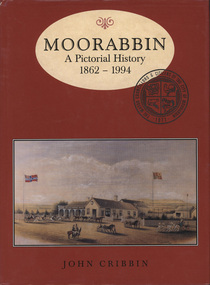
Book, "Moorabbin: A Pictorial History, 1862 - 1994", 1995
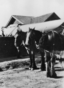
Copy of pictorial history book written by John Cribbin significantly signed by councillors and the author on the first page.The words "Moorabbin: A Pictorial History, 1862 - 1994" printed in brown colour in and oval at the top of a red, hard paper cover book, copy of an image of horse and carts and Gregg's Plough and Harrow Hotel, South Brighton below. Below that name of author "John Cribbin" is printed. -
 Glen Eira City Council History and Heritage Collection
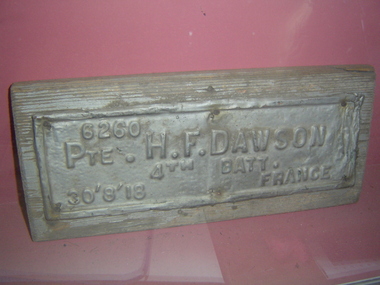
Plaque, memorial
Originally located in the City of Caulfield and City of Brighton Avenues of Honour. Metal plaque on wooden base with embossed lettering: "6260 PTE H.F. DAWSON 4th BATT. 30'8'18 FRANCE""6260 PTE H.F. DAWSON 4th BATT. 30'8'18 FRANCE" embossed on metal. -
 Glen Eira City Council History and Heritage Collection
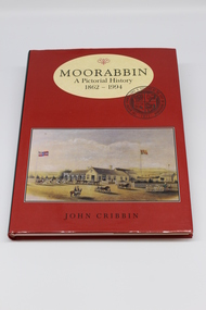
Book, "Moorabin: A Pictorial History 1862 - 1994", 1995
Copy of pictorial history book written by John Cribbin with dedication to former Mayor, Cr Noel Erich on inside of cover: "To Cr Noel Elrich, Mayor of the City of Glen Eira from Moorabbin Historical Society and the Glen Eira Volunteers. International Year of Volunteers 2001".Hard cover book with a red jacket with the title "Moorabbin: A Pictorial History, 1862 - 1994" printed in brown colour in and oval at the top of a red , hard paper cover book, copy of an image of horse and carts and Gregg's Plough and Harrow Hotel, South Brighton below. Written on inside of cover: "To Cr Noel Elrich, Mayor of the City of Glen Eira from Moorabbin Historical Society and the Glen Eira Volunteers. International Year of Volunteers 2001". -
 Glen Eira City Council History and Heritage Collection
Document (Series) - Newspaper (digital), Caulfield Contact
Generated by Caulfield City Council, transferred to Glen Eira City Council at Amalgamation.Newsletter for City of CaulfieldBy Year then by Edition/MonthThe Caulfield Contact was the official newspaper of the City of Caulfield from 1976-1994. The City of Caulfield was the Municipal Council for an area of the South Eastern suburbs of Melbourne, including Brighton East, Carnegie, Caulfield, Elsternwick, Gardenvale, Glen Huntly, McKinnon, Murrumbeena, Ormond and St Kilda East. Following Amalgamation of City of Caulfield and parts of the City of Moorabbin in 1994, the Caulfield Contact was followed by the Glen Eira News.brighton east, carnegie, caulfield, elsternwick, gardenvale, glen huntly, mckinnon, murrumbeena, ormond, st kilda east, saint kilda east, east brighton, east st kilda, east saint kildabrighton east, carnegie, caulfield, elsternwick, gardenvale, glen huntly, mckinnon, murrumbeena, ormond, st kilda east, saint kilda east, east brighton, east st kilda, east saint kilda -
 Vision Australia
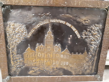
Domestic object - Object, Royal Victorian Institute for the Blind metal fire screen
On the front (rear) face of this metal firescreen is an image of the RVIB St Kilda Road building and front gardens, with the words 'Royal Victorian Institute for the Blind' in curved lettering above the building. A name plate is attached by cord to the firescreen, which reads "In Memory Of M.N. Moylan Life Member Brighton Auxiliary". It is unknown whether the firescreen was made by blind metal workers, however it shows signs of use, quite possibly at the St Kilda Road building itself.Metal fire screen with etched image and attached plateRoyal Victorian Institute for the Blind In Memory of M.N. Moylan Life Member Brighton Auxiliaryroyal victorian institute for the blind, m.n. moylan -
 Vision Australia
Plaque - Object, Guiding Light plate, 1964?
The plaque believed to have been attached to the Guiding Light structure, which was installed at AFB's Brighton office due to the efforts of President Bruce Small. Although removed some years ago, the structure was a symbol used by the Association for the Blind as a visual way to represent it's work within the community. 1 metal plate with engraving "This Guiding Light symbol of the Association for the Blind was donated by Bruce Small, Esq. Member of Committee 1944-1954. President 1954-1964. Honorary Counsellor 1964-"association for the blind, fundraising, nameplates -
 Vision Australia
Photograph - Image, Arthur Nothling shield
A brown wooden award with the words 'Arthur Nothing Shield' inscribed at the top and, in white paint, 'For competition between Friendship Swish Club & Brighton Staff'. At the base is inscribed 'for Perpetual Competition'. There are 10 smaller silver plates, however only 3 of these are inscribed: Association Staff 1966, Friendship Swish Club 1967, Friendship Swish Club 1968.Image of wooden shield with metal plaquesArthur Nothling shieldassociation for the blind, recreation -
 Vision Australia
Administrative record - Text, 67th Annual report 1962 Association for the Blind of Victoria, 1981
Articles in annual report include: a short history of the AFB, President's Report, report on Ballarat, Bendigo and Brighton Homes, financial information, the work of the Welfare Service division, opening of two flatlets for aged blind at Ballarat, resignation of Celeste Baird as choirmaster after 17 years and A Williams stepping into the role, need for a better clubhouse which has been little changed since it was built over 30 years ago, students from Ballarat Teachers college read to home residents, publication of 'Courage' magazine to keep everyone up to date on Association events, and a profile on Russian migrant Alex Momot and how the AFB assisted him settle into Australia.1 printed volume with black and white illustrationsassociation for the blind, kelaston home (ballarat), elanora home (brighton), mirridong home (bendigo), alex momot, rosalie tyers, e irvine, l adamson, mrs r clarke, matron e mcleod, a sharry, matron rosewall, mrs s mcenroe, celeste baird, e goulding, mrs a bulluss, mrs a n roach, mrs m macdowell, mrs t carson, mrs j stanley smith, pam barker, mrs l thomas, mrs a mansfield, mrs l rogerson, elsie henderson, mrs murphy, mrs w christian, h h mackenzie, sister b agar, annual reports -
 Vision Australia
Administrative record - Text, Twenty Third Annual Report of the Association for the Advancement of the Blind 1918, 1918
Annual report of the Association for the Advancement of the Blind outlined activities and events over the year, including continued support through donations despite abnormal conditions caused by the war, less attendances at Country Concert Party events however it remains in a sound financial position, a bequest of 200 pounds was received from Jean Bickford for the purpose of accommodating blinded soldiers at Brighton, the work of the Association has largely been limited in area however with the Secretary's visit to both Bendigo and Ballarat it is hoped that more is possible, a new trade of plaiting bark to make small floral baskets has been added, a near miss was incurred at the 'Re-union' at Woodburn after the hot afternoon helped generate a violent tornado which fortunately missed the Home but created havoc a few hundred metres away, and the loss of several members and supporters, including Mr Young who was killed in a tram accident and Mrs G W Paterson, who along with her husband W Paterson, an active supporter of the Home.1 volume of printed material with some illustrationsassociation for the advancement of the blind, annual reports -
 Vision Australia
Administrative record - Text, Twenty Fourth Annual Report of the Association for the Advancement of the Blind 1919, 1919
Annual report of the Association for the Advancement of the Blind outlined activities and events over the year, including withdrawal of the Country Concert Party due to the influenza epidemic, efforts being made to develop a Sewing Guild, continuation of Bark Plaiting to make small baskets, introduction of a French Polishing and Boot Repairing classes, the need for a separate building at Brighton to house the ill and the establishment of fund towards this with a 100 pound donation from the Felton Bequest, and the unfortunate increase in deaths amongst members due to the epidemic including past President T. Lowe, Country Concert Party singer Miss N Gray, and the return from active service of Dr Grey.1 volume of printed material with some illustrationsassociation for the advancement of the blind, annual reports -
 Surrey Hills Historical Society Collection
Photograph, 213 Union Road, Surrey Hills c1930, 1930
The photo shows part of the process of moving a yacht, named 'Sonia' from 213 Union Road, the home of the Fleming family. It was built in the shed garage of the house and moved from it by horse and dray. The home belonged to Harold Arthur Fleming (1891-1971) and his wife, Georgiana Phyllis (nee Griffiths: 1895-1936). Harold built the boat. They had 3 children - Eric Alexander (1918-1920), Sybil Patricia (1921-2012) and another girl. The shed /garage had been the old coach house of the adjoining property, 215 Union Road. the boat was launched at the Brighton Yacht Club. Harold was a draughtsman. The Flemings lived in a number of houses in Surrey Hills: 1. 1919 - 'Radnor' in Croydon Road; the name possibly derives from Radnorshire, Wales where Georgiana was born. 2. 1921 - 169 Union Road 3. 1931 - 213 Union Road. The donor (deceased) was the daughter of the builder and married Keith Andrew Fleming. A black & white photo with 3 draught horses in the foreground. Beyond the path and fence behind them is the roof of 213 Union Road. Between the fence and the house the view is blocked by the hull of a yacht.harold arthur fleming, miss georgiana phyllis griffiths, mrs georgiana phyllis fleming, 213 union road, horses, boating -
 Surrey Hills Historical Society Collection
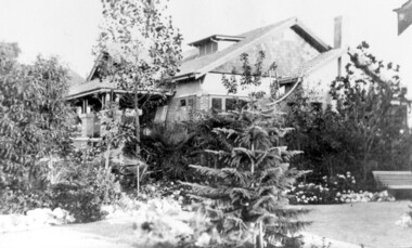
Photograph, 'Graceburn', 17 Trafalgar Street, Mont Albert
Joseph Arthur Bailey, described as a manager in electoral rolls, came to Surrey Hills some time before 1903. He was born in Brighton in 1873 and died in Burwood in 1929 and is buried in Box Hill Cemetery. He was the son of George Bailey and Georgina Hardwick, who lived in Healesville for a time but 'retired' to Surrey Hills where they are listed at 'Claremont' in Mont Albert Road in 1919. Joseph married Eleanor Beatrice Greenhill in 1897. They had 3 sons - Rupert Aitken (who served in WW1); Kenneth Alan and Edwin George. Prior to living in Trafalgar Street they lived at 9 Victoria Crescent. A black and white photograph of a brick house in the californian bungalow style with a well-established garden, as viewed from one side.trafalgar street, graceburn, house names, 1919, californian bungalow, box hill cemetery, joseph arthur bailey, mrs eleanor beatrice bailey, miss eleanor beatrice greenhill, mr rupert aitken bailey, mr kenneth alan bailey, mr edwin george bailey -
 Kew Historical Society Inc
Plan, Melbourne & Metropolitan Board of Works : Contour Plan of Melbourne & Suburbs : Melbourne Sewage, 1894
The Melbourne and Metropolitan Board of Works (MMBW) plans were produced from the 1890s to the 1950s. They were crucial to the design and development of Melbourne's sewerage and drainage system. This plan forms part of a large group of MMBW plans and maps that was donated to the Society by the Mr Poulter, City Engineer of the City of Kew in 1989. Within this collection, thirty-five hand-coloured plans, backed with linen, are of statewide significance as they include annotations that provide details of construction materials used in buildings in the first decade of the 20th century as well as additional information about land ownership and usage. The copies in the Public Record Office Victoria and the State Library of Victoria are monochrome versions which do not denote building materials so that the maps in this collection are invaluable and unique tools for researchers and heritage consultants. A number of the plans are not held in the collection of the State Library of Victoria so they have the additional attribute of rarity.Digital copy of an original MMBW plan. This contour plan shows the area identified by the MMBW for purposes of drainage and sewerage in 1894. The suburbs represented extend from Williamstown in the west to Bulleen in the east, and from Preston in the north, south to Sandringham. Suburbs are outlined in coloured ink. Red lines indicate main and branch sewers in existence at the beginning of 1894 in central and inner Melbourne. These extended as far as Williamstown and Brighton, but not yet as far as Kew, where sewering did not commence until 1901. Contour lines show the topography, which was important for indicating the fall of the land for the laying of sewers and drainage channels. Kew appears to be fairly undeveloped at this date except for railway lines and stations (the Kew and Outer Circle lines), main roads, the Kew Lunatic Asylum Reserve and Studley Park. However, the contour plan does not accurately represent the density of settlement, nor the large number of houses, which were being built in Kew and other suburbs from the 1850s to the land boom of the late 1880’s and early 1890’s. This plan is part of a large and historically significant group of MMBW plans and maps that was donated to the Society by the Mr Poulter, City Engineer of the City of Kew in 1989.mmbw contour plan of melbourne and suburbs, melbourne and metropolitan board of works, melbourne sewage, cartography -
Whitehorse Historical Society Inc.
Map, Melbourne Geological Map, 1937
Geological Map of Melbourne & Suburbs.Geological Map of Melbourne & Suburbs. Scale: 40 chains to 1 inch with inset 10 miles to 1 inch. Includes Municipal and Parish boundaries, railways and stations, electric tramways, cable tramways, Post Offices and State schools. Area bounded by Braybrook, Preston, Blackburn & Brighton. Printed on linen.Geological Map of Melbourne & Suburbs. melbourne, maps -
 Eltham District Historical Society Inc
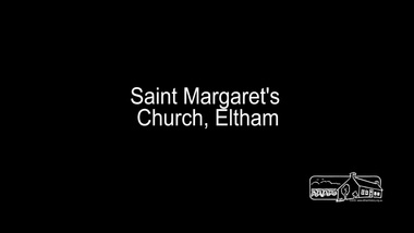
Film - Video (Digital), Geoff Paine, St Margaret's Church, Eltham: Stories of the Nillumbik Shire with Geoff Paine, June 2020
One of a series of videos "Stories from the Nillumbik Shire with Geoff Paine" Geoff Sandy, Parish Historian and Archivist gives a history of the church which was opened 12 December 1861. It is constructed of polychrome bricks (lots of different colours). References a long relationship of over 159 years between the church committee and the Eltham Hotel across the road for refeshments for church events. The land was donated by Henry Dendy, the founder of Brighton where he lived for five years before going bankrupt and moving to Eltham where he bought a steam powered flour mill on the banks of the Diamond Creek at the end of Pitt Street. The church is heritage protected as well as the 1870 parsonage, Dendy House. It was always meant to be a much bigger church and extended along the north wall. This was finally achieved in 2014. Shows views inside of the original section and the extension. Also discusses the original tall windows on the south with gold trimming and other windows with gold trimming. Some original windows have been replaced by stained glass. Discussion about the Patron Saint of the Church, Margaret of Scotland. The original window made for £1 by Yuri and Fergusson in Melbourne and possibly one of the first made in the Colony of Victoria was relocated to the north wall during the 2014 extension. The crucifix was made by Matcham Skipper. Also features the Honour Roll. The walls of the extension are mudbrick, timber from a variety of sources and very much in keeping of the character of Eltham. The bell and bell tower are original. At the end of the First World War the bell was rung so vigorously that the bell broke.MP4 Digital file 00:05:48; 672MBvideo recording, church bell, dendy house, eltham, eltham hotel, flour mill, geoff sandy, henry dendy, honour roll, matcham skipper, mudbrick construction, pitt street, st margaret's anglican church, stained glass -
 Eltham District Historical Society Inc
Document, Russell Yeoman, Tour of Historic Buildings and Locations, 1978
Self guided heritage tour information produced by the Shire of Eltham Historical Society for 1978 Eltham Community Festival of 36 locations each numbered on accompanying map. Locations and detail provided current to 1978: 1. ELTHAM SHOPPING CENTRE Whilst very little remains in the centre of historical importance, this area has interest as the "village" which developed over many years following the opening of the railway from Melbourne in 1902. Previously the shopping centre had been spread out over a long length of Main Road to the south. Shops have been continuously demolished or remodelled and the majority of buildings date from the 1950's or later. The recently erected Post Office replaced the "old" Post Office opened on the same site only in 1958. 2. WOOLWORTHS ELTHAM VILLAGE Part of the site of this modern shopping development was occupied by the former Eltham Shire Offices and Hall. The hall was paid for by public subscription whilst the Council raised a loan for the offices. The combined building was opened in 1941. It served as office and Council meeting place until 1965 and as the hall until its demolition in 1970. 3. ELTHAM WAR MEMORIAL The complex of buildings adjoining the present Shire Offices were financed by public subscription as a Memorial following World War II. Their construction and for many years their operation was organised by the now disbanded Eltham War Memorial Committee. The original buildings were the; Infant Welfare Centre, Children’s Library (now War Memorial Hall and Dental Clinic) and Kindergarten. In later years the Elderly Citizens Club was built at the rear. 4. ELTHAM SHIRE OFFICES These offices were opened in 1965 and extended in 1971 to provide additional office accommodation and the Eltham Library. They represent the last of a long line of offices and meeting places of the Eltham Shire Council and its predecessor the Eltham District Road Board. The building occupies the former site of Shillinglaw Cottage. The three tall cypress trees which stood in front of the Cottage have been retained as a feature of the office surrounds. 5. OUR LADY'S CHURCH AND SCHOOL The Catholic Church and School complex opposite the Shires Offices shows a number of stages in the development of Eltham township. The recently constructed church adjoins its predecessor (now the parish centre). Many years ago the Catholic Church was located opposite Wingrove Park and the present central site follows the northerly drift of the township. 6. SHILLINGLAW COTTAGE The Cottage was built in 1859 by George Stebbing, a local builder who was responsible for a number of other prominent buildings in the area. Its removal from the site of the Shire Offices and re-erection on the present site was financed by public subscription. It is built of handmade bricks laid in Flemish Bond with an unusual design featuring burnt "leader" bricks over the whole facade. The Cottage is occupied by Eltham Fleececrafts and will be open during the Festival and at other times during weekends. It is classified by the National Trust. 7. RAILWAY BRIDGE The timber trestle bridge over the Diamond Creek was built in 1901. Whilst all of its timbers have been replaced at various times over the years the only change to its character has been the addition of pylons and wiring for electric trains in 1923. It is one of very few similar bridges remaining in the metropolitan area. In 1976 a proposal to replace the bridge with an earth embankment and large culvert pipes was abandoned following community protests. The bridge, however, remains under threat because of the necessity for future deuplication of the railway line. 8. ELTHAM CENTPAL PARK The area between the railway and the creek has for many years been used as a park which included Eltham' s main football oval. The access road, Panther Place is named after Eltham's team playing in the Diamond Valley League. In recent years a large area extending to Bridge Street and locally known as the Town Park has been landscaped and added to the area. The excellent blending of the park with the natural landscape of the creek valley has earned a National Trust Landscape Classification. 9. OLD BAKERY On the southern corner of York Street and Main Road is an old house with a shop front which was for many years the local baker's shop. The brick bakery at the rear is of somewhat later vintage than the house. 10. BRIDGE STREET CUTTING Before reconstruction of Main Road this intersection had deep cutting embankments on all four corners, forming a distinctive feature of the entrance to Eltham. Roadworks and private development have levelled the land on the low side of the road. A memorial to the Eltham soldiers of World War I which was located at the north-western corner is now situated at the Eltham R.S.L. 11. HILLTOP MILK BAR For many years this was the site of the Eltham Post Office under the control of the Hunniford family and later their descendants the Burgoynes. It was transferred to this site in 1855, although at that time the building apparently fronted Bridge Str e et. The site contained Eltham's first telephone exchange. The post office was relocated in 1954 but the shop was operated until recently by the Burgoyne family who still own the surrounding land. 12. UNITING CHURCH and former C.B.A. BANK The former Methodist Church was built in 1880 by George Stebbing. The Sunday School extension was built in 1929 and there have been more recent extensions. The adjoining opportunity shop was built as a bank in 1874 and purchased by the Methodist Church in 1954. 13. R.S.L. HALL, TELEPHONE EXCHANGE These relatively recent buildings occupy the site of a row of shops forming part of the early ribbon of business development along Main Road. In front of the R.S.L. building is the World War I Memorial relocated from the corner of Bridge Street and Main Road. 14. ELTHAM COMMUNITY CENTRE Australia's first mudbrick "community building" was opened in April this year. Part of the site of the building was purchased in 1856 by Henry Dendy (of Brighton fame). At the rear of the land near the creek was a steam flour mill whilst Dendy's house was at the Main Road frontage of the land. His purchase totalled about 2 Ha (5 acres) and included land on the opposite side of Maria Street (Main Road). Dendy became a prominent member of the Eltham community and served one term as President of the Eltham District Road Board. In 1867 Dendy sold his land and business to William Ford of Malmsbury and shifted to Walhalla. The avenue of trees leading past the Community Centre to the creek may well have bordered the track to the mill. 15. ELTHAM HOTEL The original part of this hotel was built in 1927 following the burning of the former Watson's Eltham Hotel on the same site. The car park on the opposite side of Main Road was also the site of a hotel variously known over the years as; the Fountain of Friendship, the Fountain and the Evelyn Arms. As the Fountain of Friendship it was the first meeting place of the Eltham District Road Board in 1856. 16. ST. MARGARET'S CHURCH, PITT STREET In 1860 Henry Dendy was appointed Chairman of a committee to establish a church of England in Eltham. He donated part of his land in Pitt Street and in 1861 the church was opened. It was built by George Stebbing and remains in a well preserved state today. Th adjoining old vicarage is now named Dendy Hou se. A new mudbrick church hall is under construction on the site. The church and Dendy House are now listed on the Register of Historic Buildings. 17. NO. 86 PITT STREET Cottage built by George Stebbing and believed to be his home for some years in the 1850s. 18. LIVING AND LEARNING CENTRE The house was built in the 1850s with the kitchen at the front being added about 40 years later. By the creek below the house a number of early Eltham industries were located. These included a tannery and a brewery. 19. ELTHAM COURT HOUSE A Court of Petty Sessions was established in Eltham in 1858 and the present building dates from 1860. It is the oldest public building remaining in Eltham. In its early days the building was used as the meeting place and office of the Eltham District Road Board and as an overflow classroom for the local school. The Court House has been classified by the National Trust. The citation states that it is an example of the simple form of early brick Court House with gabled roof and porch. 20. LANDS DEPARTMENT OFFICE This building is the former police station and is probably of about the same age as the Court House. The lockup at the rear has been demolished but the old stables remain as garages. A licence was first granted for a police station at Eltham in 1856. 21. JARROLD COTTAGE The old Cottage opposite Dalton Street was formerly owned by the Jarrold family. Early records indicate that this was the building leased from the Jarrolds as a temporary police station prior to construction of the building on the corner of Brougham Street. The small building on the corner of the property was used as a boot repairer's shop. The elevated studio at the rear is a more recent construction by the present owners. 22. STATE SCHOOL RESIDENCE Erected in 1891 23. WINGROVE COTTAGE This building fills an important place in the history of Eltham and is now used as a medical clinic. It was built in 1858 for Charles S. Wingrove who was Secretary to the Eltham District Road Board and Shire Council from 1858 to 1904. During part of this period he was also Shire Engineer and was Secretary to the Heidelberg Road Board. The house was used as the office of the Board and Council for many years. Wingrove is buried in the cemetery at St. Helena. 24. WINGROVE PARK The parkland opposite Wingrove Cottage has been named after Charles Wingrove. The old Manna Gums are an outstanding feature of the park. 25. ELTHAM FRI.MARY SCHOOL NO. 209 The school first opened in the slab building in 1855 and operated from the present site since 1857. The oldest part of the present school is the stone building erected in 1876. The first school teacher, David Clark remained at the school until 1888. This school is the government township and has always been known as the Eltham School. An earlier school (no.371) known as Little Eltham School operated in Swan Street from 1853 to 1872. 26. "SHOESTRING" This house was built for school teacher David Clark. It has been extensively extended in recent years but the extensions do not detract from the character of the older part of the building. 27. ELTHAM CEMETERY The cemetery contains the graves of many of the district's pioneers . 28. MONTSALVAT This unique complex of buildings was commenced in 1935 by the late Justus Jorgensen and its development has extended over many years. Montsalvat has exerted a significant impact on Eltham The earth and stone construction of many of the buildings has influenced local architecture to a great extent and it has served as a "nerve centre" of the local artistic community. Montsalvat is open to the public for a small charge. 29. MAIN ROAD BRIDGE This location has been the main crossing of Diamond Creek since the earliest days of settlement. The present concrete bridge was erected in 1925 .and was preceded by a number of timber bridges. 30. ELTHAM LOWER PARK This park, being an unusually large flat area for Eltham, was originally the local racecourse. Horse races were held here from 1855 and the area was gazetted as a reserve for a racecourse and recreation reserve in 1857. The park is well known as a venue for school "bird days" and more recently as the site of the Diamond Valley Railway. This miniature railway features scale models of modern and old locomotives and rolling stock and has operated on this site since 1961 . Before that the railway operated at Chelsworth Park, Ivanhoe. 31. FALKINER HOUSE Frederick Falkiner was one of the earliest settlers in the Eltham township area and occupied a substantial leasehold prior to the first land sales. Early records show that Falkiner was the subject of a number of complaints from his neighbours but he has nevertheless been considered a prominent enough citizen to have a street named for him. This house was the home of Evelyn (Ely) Falkiner a member of Frederick's family. 32. WEST HOUSE Behind the large house on the hill is an early house built by the West family. This was relocated from a site near the front of the land by the present owner Mr. Fabbro. 33. FALKINER HOUSE This very old house is believed to have been the home of Frederick and may have been Eltham's first post office. Falkiner was the first post master for a short period. in 1854/55. 34. WITHERS HOUSE This house was the home of famous artist Walter Withers who shifted here from Heidelberg in 1903. 35. ELTHAM HIGH SCHOOL This school celebrated its jubilee this year, having commenced as the Eltham Higher Elementary School 50 years ago. 36. DIAMOND CREEK FOOTWAY If returning from the High School to the town centre the footpath by the bank of the Diamond Creek provides a pleasant route to finish your walk. The creek is a major tributary of the Yarra River. Together with its own major tributaries Arthurs Creek and Running Creek it commences on the southern slopes of the Dividing Range at Kinglake. It gives the name Diamond Valley to an area extending well beyond its actual drainage catchment.Recognition of the significance of various landmarks to the history of the Eltham community as of 1978‘shoestring’, 1978, bridge street cutting, burgoyne store, c.b.a. bank, diamond creek trail, eltham cemetery, eltham central park, eltham community centre, eltham community festival, eltham court house, eltham festival, eltham high school, eltham hotel, eltham lower park, eltham primary school, eltham railway trestle bridge, eltham shire offices, eltham shopping centre, eltham state school no. 209, eltham village, eltham war memorial, falkiner house, heritage trail, hilltop milk bar, jarrold cottage, lands department office, living, living and learning centre, main road bridge, montsalvat, old bakery, our eltham artistic recollections, our lady help of christian’s church, our lady help of christian’s primary school, pitt street, post office, r.s.l. hall, shillinglaw cottage, st margaret’s church, state school residence, stebbing cottage, telephone exchange, uniting church, west house, wingrove cottage, wingrove park, withers house, woolworths -
Port Melbourne Historical & Preservation Society
Document - Notice, Land auction, Williamstown Road to Plummer Street, Port Melbourne, R Holden Stone, Borough Surveyor Brighton and Port Melbourne, Mar 1887
Large auction notice advertising sale of land Williamstown Road to Plummer Street 19.3.1887, with general (distorted) plan of Port Melborne and a larger plan of the allotmentstown planning, fishermans bend, land sales -
 Royal Brighton Yacht Club
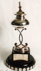
Cup, Almeida Cup
Almeida Cup Donor: Unknown Deed of Gift: No The trophy was presented in memory of William C. Almeida who was killed during a bank robbery. A memorial was erected in the park in Hampton opposite Linacre Road and Hampton Street. An inscription reads ‘Erected in memory of William C. Almeida of the Commercial Bank Hampton who gave his life in defence of his Trust 23.4.24. Aged 33 years.’ The trophy was originally used for B Division, now used for Combined Division on AMS handicap and raced on the same day as the Gullett Cup for PHD handicap and the Worcester Cup for IRC handicap. First Winner: Rita, C. W. Campbell 1925/26 almeida, cup, ams, combined division -
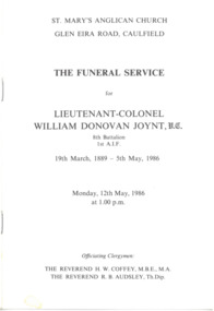 Melbourne Legacy
Pamphlet - Document, The Funeral Service for Lieutenant-Colonel William Donovan Joynt, V.C, 1986
The printed funeral service for Lt Colonel Donovan Joynt held on 12 May 1986 at St Mary's Anglican Church, Glen Eira Road, Caulfield. (Part of a photo album page(Cat.No. 01588) about the life of L/ Donovan Joynt). The Legacy Service was delivered by the President of Melbourne Legacy, Legatee R.N. Wheeler, and Legatee K.D. Green, Chairman of the Legacy Co-ordinating Council delivered an address. Brigadier B. Wade, Commander, 3rd Military District read Psalm 90 (Lord, you have been our dwelling place throughout all generations. Before the mountains were born or you brought forth the whole world, from everlasting to everlasting you are God.). Joynt was buried in Brighton General Cemetery with full military honours. Part of the collection of material held by Melbourne Legacy on Legatee Donovan Joynt, a prominent Australian.Printed pamphlet, black on white, sheets folded and stapled.donovan joynt, funeral -
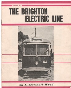 Ballarat Tramway Museum
Book, Leon Marshall -Wood, "The Brighton Electric Line", 1956, 1958
.1 - Twenty page booklet on the history of the Brighton Electric Line by Leon Marshall-Wood, published 1956. Gives a brief history of the electric tramway operated by the Victorian Railways between St. Kilda Station and the Brighton Beach railway station, that commenced operation in 1905. The booklet was priced 2/-, published by the Traction Publications. Has 18 photographs, map 1905 and present day (when printed), rolling stock roster and notes and on the rear cover has details of the AETA. Front cover has horizontal crimson stripes. Has details of the AETA on the back cover and listing of some publications. Second copy from Ian Stanley added 24-1-2016. .2 - as for above - second edition, 1958, similar text, different photo layout and different front cover photo. See Reg Item 7631i for a scan of the 1966 edition.On front cover of first copy of .1 - top right hand corner; "N.Z.R.L.S / with compliments" and initials. Under title of book, "Price to Society 18/- Aust. per doz. / Retails 2/-" On page 3 of second copy of .1 - "Ian J Stanley 28 Park Road, South Camberwell, SE6, BK3746" On page 3 of .2 - "Ian J Stanley" in ink.trams, tramways, vr, melbourne, brighton, st kilda -
 Ballarat Tramway Museum
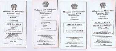
Ephemera - Timetable/s, Melbourne and Metropolitan Tramways Board (MMTB), Set of 24 MMTB Melbourne tram timetables, 1969
Set of 24 MMTB timetables for various routes, dated July 1969. Generally includes Sat and Suns, Good Friday and Christmas day as well as weekdays, unless noted otherwise. Also includes a map of the route, detailed time points, sections, connecting services, fares, and organisation address - 616 Little Collins St. Melbourne. Have been folded into ten portions. All on white paper unless noted otherwise. Items shown with an # - have a sticker modifying timetable information details on the front page. 1154.1 - Route 4 - Carnegie - City .2 - Route 4D - East Malvern (Darling Road) - City # .3 - Route 5 - Malvern Burk Road, - City # .4 - Route 6 - Glen Iris - City # .5 - Route 7 - Camberwell - City # .6 - Route 8 - Toorak - City # .7 - Routes 9, 10 and 12 - South Melbourne and St Kilda Beach - City (Brunswick St.) - via Collins St. .8 - Routes 10, 11 - West Preston and routes 9 & 9A Northcote .9 - Routes 15 & 22 - Moreland and 1 & 21 - East Coburg .10 - Route - 15 & 16 - St Kilda Beach and 1 & 2A - South Melbourne Beach - via Swanston St. .11 - Route 19 - North Coburg - City # .12 - Route 42 - Mont Albert - City # .13 - Routes 48 - North Balwyn and Burwood - City .14 - as above, but for Saturdays and Sundays on pink paper .15 - Routes 55 & 56, West Coburg - City - (William St.) - Domain Road. .16 - Route 57 - West Maribyrnong - City .17 - Route 59 - Essendon (Aerodrome) - City .18 - Route 64 & 65 - East Brighton - City .19 - Route 69 - Kew Cotham Road - St. Kilda Beach # .20 - Route 70 - Wattle Park - City # .21 - Routes 77 - Prahran - City, 78 - North Richmond - Prahran, 79 - North Richmond - St Kilda Beach .22 - Route 82 - Footscray to Moonee Ponds .23 - Route 88 - East Preston - City and Route 96, East Brunswick - City .24 - as above but for Saturdays and Sundays on pink paper. Images of a sample of documents added 16-11-2013.mmtb, timetables, melbourne -
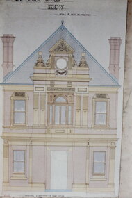 Kew Historical Society Inc
Slide - Architectural Drawing, Kew Public Offices, 1887
A civic campaign for new public offices developed in Kew in the 1880s. After much deliberation, the location chosen was the junction of Bulleen and Cotham Roads. The buildings were designed by George Watson and John Henry Harvey, architects within the Department of Public Works (Victoria). Building was commenced in 1887, and after one year, the buildings were opened. The Post Office was transferred to the new Commonwealth Government in 1901. The Police Station and Court House, sold by the Victorian Government to the City of Boroondara in 2007, are now a community cultural centre and performing arts venue.The buildings were listed on the Victorian Heritage Register Register (HO885) in 1991. They are historically and architecturally significant to the State Of Victoria because Watson and Harvey's designs exhibit diversity in integrating civil offices, they accommodate the apex of road junctions, and they demonstrate a departure from the contemporaneously favoured High Victorian Classical to the Queen Anne style in the design of civic buildings. 35mm colour transparency of an original plan by George Watson and John Henry Harvey, architects of the Department of Public Works (Victoria), in 1887 for New Public Offices at Kew. This plan was copied by the donor from an original held at the Commonwealth Archives in Brighton (Vic). The copy was made to illustrate a report that the donor made on ‘The functional planning design, building materials and construction methods of the Kew Post Office’ as part of course work at RMIT.THE PUBLIC OFFICES, KEW / SCALE 2 FEET TO ONE INCHkew court house, kew police station, architectural drawings, khs - slides, new public offices — kew (vic.), architecture — queen anne style