Showing 1207 items
matching dairies
-
 Greensborough Historical Society
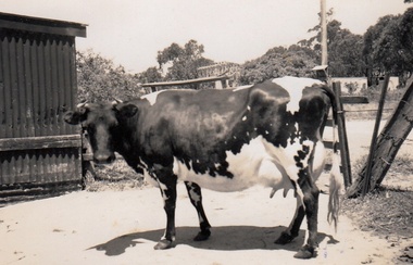
Photograph - Digital Image, Cherel Sartori, Cows at Kell's Cottage 1956, 01/01/1956
Photograph of a cow at Kell's Cottage in the 1940s. The house was built 1917, at 112 Henry Street Greensborough by William Mitchell on the 60 acre dairy farm owned by Ethel and Walter Kell. This collection of photographs was copied by Cherel Sartori (who owned the house from 1990-2000), following a visit by Claude Amiet who lived in the house as a child in the early 20th century.An indication of the rural aspect of this area in the mid-20th century.Digital copy of black and white photographkell's cottage, claude amiet, cherel sartori -
 Greensborough Historical Society
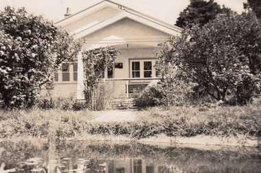
Photograph - Digital Image, Cherel Sartori, Electricity connected in Henry Street, 1950s, 1956c
Kell's Cottage with electricity connected 1950s. The house was built 1917, at 112 Henry Street Greensborough by William Mitchell on the 60 acre dairy farm owned by Ethel and Walter Kell. This collection of photographs was copied by Cherel Sartori (who owned the house from 1990-2000), following a visit by Claude Amiet who lived in the house as a child in the early 20th century.An indication of the rural aspect of this area in the mid-20th century.Digital copy of black and white photographkell's cottage, claude amiet, cherel sartori -
 Greensborough Historical Society
Photograph - Digital Image, Cherel Sartori, Paddock and gates in Henry Street, 1950s, 1956c
Paddock and driveway at Kell's Cottage 1950s. The house was built 1917, at 112 Henry Street Greensborough by William Mitchell on the 60 acre dairy farm owned by Ethel and Walter Kell. This collection of photographs was copied by Cherel Sartori (who owned the house from 1990-2000), following a visit by Claude Amiet who lived in the house as a child in the early 20th century.An indication of the rural aspect of this area in the mid-20th century.Digital copy of black and white photographkell's cottage, claude amiet, cherel sartori -
 Greensborough Historical Society
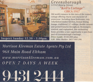
Photograph - Digital Image, Cherel Sartori, Sale notices, Kell's Cottage, 2000, 2000_
Advertisements for Kell's Cottage when sold in 2000. The house was built 1917, at 112 Henry Street Greensborough by William Mitchell on the 60 acre dairy farm owned by Ethel and Walter Kell. This collection of photographs was copied by Cherel Sartori (who owned the house from 1990-2000), following a visit by Claude Amiet who lived in the house as a child in the early 20th century.Digital copy of colour advertisementskell's cottage, claude amiet, cherel sartori -
 Greensborough Historical Society
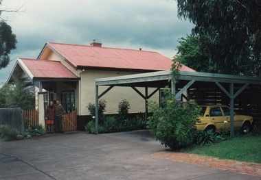
Photograph - Digital Image, Cherel Sartori, Exterior of Kell's Cottage, 2000, 2000_
Exterior of Kell's Cottage when sold in 2000. The house was built 1917, at 112 Henry Street Greensborough by William Mitchell on the 60 acre dairy farm owned by Ethel and Walter Kell. This collection of photographs was copied by Cherel Sartori (who owned the house from 1990-2000), following a visit by Claude Amiet who lived in the house as a child in the early 20th century.Digital copy of colour photographskell's cottage, claude amiet, cherel sartori -
 Greensborough Historical Society
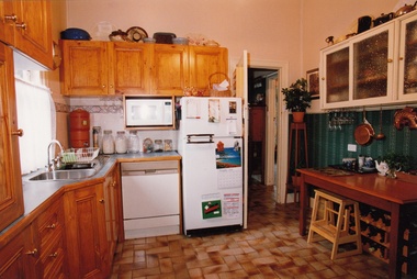
Photograph - Digital Image, Cherel Sartori, Interior of Kell's Cottage, 2000, 2000_
Interior of Kell's Cottage when sold in 2000. The house was built 1917, at 112 Henry Street Greensborough by William Mitchell on the 60 acre dairy farm owned by Ethel and Walter Kell. This collection of photographs was copied by Cherel Sartori (who owned the house from 1990-2000), following a visit by Claude Amiet who lived in the house as a child in the early 20th century.Digital copy of 4 colour photographskell's cottage, claude amiet, cherel sartori -
 City of Moorabbin Historical Society (Operating the Box Cottage Museum)
Tools, Slide-hammer Nail puller,c1880, c1880
c1880 Many tools were imported from USA manufacturers by early settlers in Moorabbin Shire and local blacksmiths modified and maintained these tools for the other settlers who were establishing the homes, market gardens, farms, orchards and various businesses. Early settlers were self reliant and repaired their own equipment for kitchen,dairy, farm, horses, carts using various tools . This slide-hammer nail puller is typical of the type used by early settlers in Moorabbin Shire c1900A steel slide-hammer nail puller c1880SMITH & HEMENWAY CO.N.Y. / Pat July (18) 78, Oct 79, July 81/ TRADEMARK 'GIANT' No.1slide hammer nail pullers, carpenters, builders, early settlers, market gardeners, blacksmiths, tools, building equipment, hammers, moorabbin shire, bentleigh, mckinnon, highett, cheltenham,mcewan james pty ltd, melbourne, bunnings pty ltd, smith & hemenway co. new york usa, -
 City of Moorabbin Historical Society (Operating the Box Cottage Museum)
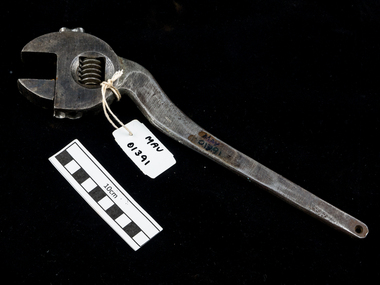
Tools, shifting spanner large c1930, c1930
An adjustable or shifting spanner or adjustable wrench is an open-end wrench with a movable jaw, allowing it to be used with different sizes of fastener head (nut, bolt, etc.) rather than just one fastener size, as with a conventional fixed spanner. Early settlers were self reliant and repaired their own equipment for kitchen,dairy, farm, horses, carts using various tools . This steel shifting spanner is typical of the type used by early settlers in Moorabbin Shire c1930A large heavy steel curved neck shifting spanner with adjustable screwFLAG BRAND / MADE IN GERMANYtools, spanners, shifting spanners, wrenches, early settlers, market gardeners, blacksmiths, tools, building equipment, hammers, moorabbin shire, bentleigh, mckinnon, highett, cheltenham,mcewan james pty ltd, melbourne, bunnings pty ltd, -
 Kew Historical Society Inc
Photograph - Flooding of the Yarra River in North Kew, 1934
North Kew, now divided between Kew and Kew East, bordered the Yarra River. As such, it was a region subject to flooding in the Yarra Valley. Development beyond this point (ie Kellett Grove) was limited by the City of Kew's planning regulations. Prior to urban development, the area since European settlement and the first land sales in the district in the 1840s, had been used for dairy farming. Small sepia snapshot taken from the river ramp of a house at 8 Kellett Grove, in what was then known as North Kew. The point of view is from a backyard looking towards Fairfield. Beyond the fence line are two almost submerged houses. A number of people are in a motor driven boat midstream. Fairfield at this period, (ie 1934) was noted for its limited river side development. Verso: 2/12/34 / TAKEN FROM OUR RAMPyarra river -- north kew, floods -- yarra valley, floods -- north kew, floods -- 1929, floods -- 1934, natural disasters -- kew -
 Kew Historical Society Inc
Photograph - 8 Kellett Grove, North Kew, 1929
North Kew, now divided between Kew and Kew East, bordered the Yarra River. As such, it was a region subject to flooding in the Yarra Valley. Development beyond this point (ie Kellett Grove) was limited by the City of Kew's planning regulations. Prior to urban development, the area since European settlement and the first land sales in the district in the 1840s, had been used for dairy farming. Small sepia snapshot taken of the front of 8 Kellett Grove, in what was then known as North Kew. Verso: 8 KELLETT GROVE / NORTH KEW / 1929 / 418 kellett gove -- north kew, californian bungalows, houses -- kellett grove -- kew (vic.) -
 Kew Historical Society Inc
Photograph - Flooding of the Yarra River in North Kew, 1934
North Kew, now divided between Kew and Kew East, bordered the Yarra River. As such, it was a region subject to flooding in the Yarra Valley. Development beyond this point (ie Kellett Grove) was limited by the City of Kew's planning regulations. Prior to urban development, the area since European settlement and the first land sales in the district in the 1840s, had been used for dairy farming. Small sepia snapshot taken from the back yard of a house at 8 Kellett Grove, in what was then known as North Kew. The point of view is from a backyard looking towards Fairfield. Floodwaters have submerged the fence and a clothes line. Verso: BACKYARD NTH. KEWyarra river -- north kew, floods -- yarra valley, floods -- north kew, floods -- 1934, natural disasters -- kew -
 Kew Historical Society Inc
Photograph - Flooding of the Yarra River in North Kew, 1934
North Kew, now divided between Kew and Kew East, bordered the Yarra River. As such, it was a region subject to flooding in the Yarra Valley. Development beyond this point (ie Kellett Grove) was limited by the City of Kew's planning regulations. Prior to urban development, the area since European settlement and the first land sales in the district in the 1840s, had been used for dairy farming. Small sepia snapshot taken from the back yard of a house at 8 Kellett Grove, in what was then known as North Kew. The point of view is from a backyard looking towards Fairfield. Verso: 8 KELLETT GROVEyarra river -- north kew, floods -- yarra valley, floods -- north kew, floods -- 1934, natural disasters -- kew -
 Kew Historical Society Inc
Photograph - Flooding of the Yarra River in North Kew, 1934
North Kew, now divided between Kew and Kew East, bordered the Yarra River. As such, it was a region subject to flooding in the Yarra Valley. Development beyond this point (ie Kellett Grove) was limited by the City of Kew's planning regulations. Prior to urban development, the area since European settlement and the first land sales in the district in the 1840s, had been used for dairy farming. Small sepia snapshot taken from the back yard of a house at 8 Kellett Grove, in what was then known as North Kew. The point of view is from a backyard looking towards Fairfield. Verso: OUR BACKYARD 8 KELLETT GROVEyarra river -- north kew, floods -- yarra valley, floods -- north kew, floods -- 1934, natural disasters -- kew -
 Kew Historical Society Inc
Photograph - View of the Yarra River from 8 Kellett Grove, North Kew, 1948
North Kew, now divided between Kew and Kew East, bordered the Yarra River. As such, it was a region subject to flooding in the Yarra Valley. Development beyond this point (ie Kellett Grove) was limited by the City of Kew's planning regulations. Prior to urban development, the area since European settlement and the first land sales in the district in the 1840s, had been used for dairy farming. The view from the rear of 8 Kellett Grove predates the construction of the Eastern Freeway so provides a rare view of the area before it was built.Small sepia snapshot taken from the back yard of a house at 8 Kellett Grove, in what was then known as North Kew. A tower of the Kew Asylum on the top left of the horizon assist the viewer to recognise that the land to the left of the river is in Kew and Studley Park.Verso: NORTH KEW 1948 / Stamped 51019yarra river -- north kew, kellett grove -- north kew -
 Kew Historical Society Inc
Photograph - Flooding of the Yarra River in North Kew, 1934
North Kew, now divided between Kew and Kew East, bordered the Yarra River. As such, it was a region subject to flooding in the Yarra Valley. Development beyond this point (ie Kellett Grove) was limited by the City of Kew's planning regulations. Prior to urban development, the area since European settlement and the first land sales in the district in the 1840s, had been used for dairy farming. Small sepia snapshot of floodwaters taken from near Kellett Grove, in what was then known as North Kew. The point of view is from a backyard looking towards Fairfield. In the foreground ar two men in a rowboat.Verso: OUR BACKYARD / Stamped 3 163yarra river -- north kew, floods -- yarra valley, floods -- north kew, floods -- 1934, natural disasters -- kew -
 Kew Historical Society Inc
Photograph - Flooding of the Yarra River in North Kew, 1934
North Kew, now divided between Kew and Kew East, bordered the Yarra River. As such, it was a region subject to flooding in the Yarra Valley. Development beyond this point (ie Kellett Grove) was limited by the City of Kew's planning regulations. Prior to urban development, the area since European settlement and the first land sales in the district in the 1840s, had been used for dairy farming. Small sepia snapshot of floodwaters taken from near Willsmere Road, in what was then known as North Kew. The point of view is looking towards Fairfield. In the foreground are two figures viewing a group in a rowboat in the middle of the flooded river. Semi-submerged street lighting indicates that entire streets had been. overwhelmed by the flood waters. Verso: WILLSMERE ROAD NORTH KEW / Stamped 3 163yarra river -- north kew, floods -- yarra valley, floods -- north kew, floods -- 1934, natural disasters -- kew, willsmere road -
 Kew Historical Society Inc
Photograph - Flooding of the Yarra River in North Kew, 1934
North Kew, now divided between Kew and Kew East, bordered the Yarra River. As such, it was a region subject to flooding in the Yarra Valley. Development beyond this point (ie Kellett Grove) was limited by the City of Kew's planning regulations. Prior to urban development, the area since European settlement and the first land sales in the district in the 1840s, had been used for dairy farming. Small sepia snapshot of floodwaters in North Kew. The point of view is of two houses belonging to local families that were surrounded by floodwater. Verso: HYATTS HOUSE / WILLSMERE ROAD / Stamped 3 163yarra river -- north kew, floods -- yarra valley, floods -- north kew, floods -- 1934, natural disasters -- kew, willsmere road -
 Kew Historical Society Inc
Photograph - Flooding of the Yarra River in North Kew, 1934
North Kew, now divided between Kew and Kew East, bordered the Yarra River. As such, it was a region subject to flooding in the Yarra Valley. Development beyond this point (ie Kellett Grove) was limited by the City of Kew's planning regulations. Prior to urban development, the area since European settlement and the first land sales in the district in the 1840s, had been used for dairy farming. Small sepia snapshot of floodwaters in North Kew, from the rear of 8 Kellett Grove. Verso: OUR BACKYARD / Stamped 52yarra river -- north kew, floods -- yarra valley, floods -- north kew, floods -- 1934, natural disasters -- kew, willsmere road -
 Kew Historical Society Inc
Photograph - Grandfather and granddaughter in the yard of 8 Kellett Grove, Kew, 1934
North Kew, now divided between Kew and Kew East, bordered the Yarra River. As such, it was a region subject to flooding in the Yarra Valley. Development beyond this point (ie Kellett Grove) was limited by the City of Kew's planning regulations. Prior to urban development, the area since European settlement and the first land sales in the district in the 1840s, had been used for dairy farming. Vivid photograph contrasting domestic life and relationships with natural disasters such as the flood of 1934.Small sepia snapshot of a grandfather and granddaughter sitting in the backyard of 8 Kellett Grove, North Kew, with the floodwaters stretching behind them.Verso: GRANDDAD AND I IN BACKYARDyarra river -- north kew, floods -- yarra valley, floods -- north kew, floods -- 1934, natural disasters -- kew, willsmere road -
 Kew Historical Society Inc
Photograph - Submerged houses in River Avenue, North Kew, 1934
North Kew, now divided between Kew and Kew East, bordered the Yarra River. As such, it was a region subject to flooding in the Yarra Valley. Development beyond this point (ie Kellett Grove) was limited by the City of Kew's planning regulations. Prior to urban development, the area since European settlement and the first land sales in the district in the 1840s, had been used for dairy farming. Vivid photograph contrasting domestic life and relationships with natural disasters such as the flood of 1934.Small sepia snapshot of two submerged houses belonging to local families in River Avenue, North Kew, during the 1934 floods. The view is presumably from near Kellett Grove looking north towards Fairfield.Verso: COES & HYATTS ROOF / RIVER AVENUE / Stamped: 6414yarra river -- north kew, floods -- yarra valley, floods -- north kew, floods -- 1934, natural disasters -- kew -
 Kew Historical Society Inc
Photograph - Flooding of the Yarra River in North Kew, 1934
North Kew, now divided between Kew and Kew East, bordered the Yarra River. As such, it was a region subject to flooding in the Yarra Valley. Development beyond this point (ie Kellett Grove) was limited by the City of Kew's planning regulations. Prior to urban development, the area since European settlement and the first land sales in the district in the 1840s, had been used for dairy farming. Vivid photograph contrasting domestic life and relationships with natural disasters such as the flood of 1934.Small sepia snapshot of the donors grandfather rescuing the family dog's kennel from rising floodwaters at the rear of 8 Kellett Grove, North Kew, .Verso: DAD SECURING NIPPY'S DOG KENNEL / Stamped 6414yarra river -- north kew, floods -- yarra valley, floods -- north kew, floods -- 1934, natural disasters -- kew -
 Kew Historical Society Inc
Photograph - Flooding of the Yarra River in North Kew, 1934
North Kew, now divided between Kew and Kew East, bordered the Yarra River. As such, it was a region subject to flooding in the Yarra Valley. Development beyond this point (ie Kellett Grove) was limited by the City of Kew's planning regulations. Prior to urban development, the area since European settlement and the first land sales in the district in the 1840s, had been used for dairy farming. .Small sepia snapshot of a local family's house in what was then River Avenue, North Kew being surrounded by floodwaters.Verso: THE SIDE OF RYANSyarra river -- north kew, floods -- yarra valley, floods -- north kew, floods -- 1934, natural disasters -- kew -
 Kew Historical Society Inc
Photograph - Flooding of the Yarra River in North Kew, 1934
North Kew, now divided between Kew and Kew East, bordered the Yarra River. As such, it was a region subject to flooding in the Yarra Valley. Development beyond this point (ie Kellett Grove) was limited by the City of Kew's planning regulations. Prior to urban development, the area since European settlement and the first land sales in the district in the 1840s, had been used for dairy farming. .Small sepia snapshot of what was then River Avenue, North Kew submerged by floodwaters.The photo was taken in the vicinity of 8 Kellett Grove, North Kew. Verso: TAKEN FROM OUR STREET JUST SEE A BIT OF RYAN'S FENCE / 1934yarra river -- north kew, floods -- yarra valley, floods -- north kew, floods -- 1934, natural disasters -- kew -
 Kew Historical Society Inc
Photograph - Flooding of the Yarra River in North Kew, 1934
North Kew, now divided between Kew and Kew East, bordered the Yarra River. As such, it was a region subject to flooding in the Yarra Valley. Development beyond this point (ie Kellett Grove) was limited by the City of Kew's planning regulations. Prior to urban development, the area since European settlement and the first land sales in the district in the 1840s, had been used for dairy farming. .Small sepia snapshot of the devastation caused by the 1934 flood.The photo was taken in the vicinity of Kellett Grove, North Kew and includes the roof of Chipperfield's Boathouse as well as other local houses.Verso: THIS IS CHIPPERFIELD'S BOAT SHEDS & COES & WILLIAMS TAKEN FROM OUR STREET / 1934yarra river -- north kew, floods -- yarra valley, floods -- north kew, floods -- 1934, natural disasters -- kew, chipperfields boathouse -
Kew Historical Society Inc
Archive (Sub-series) - Subject File, Elm House, 72 Walpole Street (Kew), 1983
Sally Ann VenablesReference, Research, InformationProvenance (Donor) OrderSubject file containing a school research assignment completed by Sally Ann Venables of the history of Elm House (later Cloverlea), 72 Walpole Street. The 15-page report was completed in 1983 while Sally was a pupil of Kew High School. Owners of the house recorded in the report include Horace Samson, George Gray Allan, George Brinsden Vasey, Matthew Montgomerie Wilson, and Ethel Dalton. The writer contends that at some stage, the house operated as a dairy. kew (vic) - history, kew (vic) - dairies, elm house - 72 walpole street (kew), cloverlea - 72 walpole street (kew), sally ann venables, houses - walpole street - kew (vic)kew (vic) - history, kew (vic) - dairies, elm house - 72 walpole street (kew), cloverlea - 72 walpole street (kew), sally ann venables, houses - walpole street - kew (vic) -
 Kew Historical Society Inc
Photograph - Yarra River, Kew, 1925
Henry Beater Christian (1886-1962) , was a descendant of one of the earliest settler families in Kew. Employed at the Kew Asylum as a 'public servant', he was a skilled amateur photographer, photographing numerous scenes in Kew and on his travels around Victoria. The majority of his photographs date from 1916 to 1929. His finest photographs are housed in two photograph albums. Digital copy of a photograph from page 3 of the 47-page photograph album containing 261 gelatinous silver images, loaned by Diane Washfold with permission given to digitise and hold a copy in our collection. A photograph of a stretch of the Yarra River at Kew. From the 1840s, at the Crown Land Sales, lots adjacent to the river were sold and developed as dairy farms, hence the presence of cattle until the land was subdivided or created into golf courses during the twentieth century. "Yarra Rvr / Kew / 1925"henry beater christian (1886-1962), landscape photography, kew (vic.) — yarra river, christian-washfold collection, photograph albums, dairying -- kew (vic.) -
 Kiewa Valley Historical Society
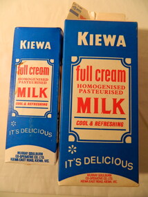
Milk Cartons - 2 litre & 1 litre, 2 litres - 1986. 1 litre - 1980's
The North-Eastern Dairy Company was established on 14th December 1892 as a butter factory and built in 1893. In 1928 a new butter factory was built and a milk products factory in 1952. Whole milk sales commenced in 1951, with pasteurised, homogenised milk in both bottles and cartons being sold in the 1980's. Devondale / Murray Goulburn was established in 1950. Cartons enabled the safe transportation and storage of milk. The North East Dairy Company enabled the dairy farmers in the Kiewa Valley to send their milk and milk products eg. cream to the factory at Kiewa. The factory bought its own cream carting vehicles during WW1. The 'full cream / homogenised / pastuerised / milk' is an example of the milk available in the 1980's as many different varieties of ingredients followed in later years.Blue, red & white waterproof sealed cardboard box used for storing fresh milk from the Kiewa factory 'Murray Goulburn'. The large box contains 2 litres and the smaller box, 1 litre. Each of the 4 faces have print - 2 have the title, 1 has advertising and 1 has instructions on how to store the carton of milk2 litre - Use by Date stamped at the top: 'Un Ed Oct 19' 1 litre - Use by Date stamped at the top: 'Ned Feb. 13'milk, murray goulburn, kiewa butter factory, kiewa milk products -
 Greensborough Historical Society
Photograph - Digital Image, Cherel Sartori, Claude Amiet at Kell's Cottage 1920s, 1920c
Photograph of Claude Amiet and others at Kell's Cottage in the 1920s. The house was built 1917, at 112 Henry Street Greensborough by William Mitchell on the 60 acre dairy farm owned by Ethel and Walter Kell. This collection of photographs was copied by Cherel Sartori (who owned the house from 1990-2000), following a visit by Claude Amiet who lived in the house as a child in the early 20th century.Digital copy of black and white photographkell's cottage, claude amiet, cherel sartori -
 Greensborough Historical Society
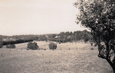
Photograph - Digital Image, Cherel Sartori, Looking east from Henry Street to the river 1956, 01/01/1956
Looking from Henry Street east to the Plenty River, 1956. The house was built 1917, at 112 Henry Street Greensborough by William Mitchell on the 60 acre dairy farm owned by Ethel and Walter Kell. This collection of photographs was copied by Cherel Sartori (who owned the house from 1990-2000), following a visit by Claude Amiet who lived in the house as a child in the early 20th century.An indication of the rural aspect of this area in the mid-20th century.Digital copy of black and white photographkell's cottage, claude amiet, cherel sartori -
City of Moorabbin Historical Society (Operating the Box Cottage Museum)
Tools, Nail remover snip c 1900, c1900
These forged nail snips we used to remove embedded nails by builders. Among the early settlers in Moorabbin Shire were blacksmiths who made tools for the other settlers who were establishing the homes, market gardens, farms, orchards and various businesses. Early settlers were self reliant and repaired their own equipment for kitchen,dairy, farm, horses, carts using various tools . This hammer is typical of the type used by early settlers in Moorabbin Shire c1900This forged steel nail snip was used to remove embedded nails by builders c1900forged nail snips, early settlers, market gardeners, blacksmiths, tools, building equipment, hammers, moorabbin shire, bentleigh, mckinnon, highett, cheltenham,mcewan james pty ltd, melbourne, bunnings pty ltd,