Showing 4334 items
matching railway road
-
 Ringwood and District Historical Society
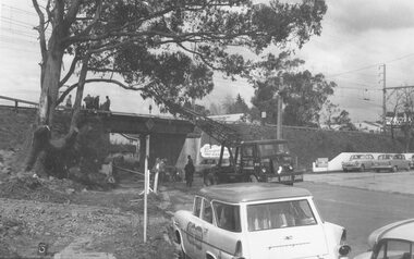
Photograph, Maroondah Highway West, Ringwood- 1965. Wantirna Road bridge widening
... Written below one photograph: "Wantirna Road railway bridge...: "Wantirna Road railway bridge- preparing to widen underpass, 1965 ...Black and white photograph (2 copies)Written below one photograph: "Wantirna Road railway bridge- preparing to widen underpass, 1965. -
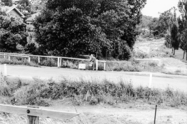
 Glenelg Shire Council Cultural Collection
Photograph - Photograph - Casterton, Victoria, n.d
... Black and white photo. Dirt road, railway crossing, man... road, railway crossing, man near side of crossing; car on other ...SOURCED FROM CASTERTON TOWN HALL (FORMER SHIRE OF GLENELG)Black and white photo. Dirt road, railway crossing, man near side of crossing; car on other side of crossing. -
Port Melbourne Historical & Preservation Society
Letter - Proposed railway along Howe Parade to Webb Dock, 1973 - 1983
... Correspondence relating to proposed railway along Howe Road... relating to proposed railway along Howe Road to Webb Dock: letter ...Correspondence relating to proposed railway along Howe Road to Webb Dock: letter from V Doube to Gordon Edwardsfrederick charles jackson, town clerks, local government - city of port melbourne, piers and wharves - webb dock, state government victoria, v j doube, e r meagher, gordon edwards -
Port Melbourne Historical & Preservation Society
Letter - Proposed railway along Howe Parade to Webb Dock, 1973 - 1983
... Correspondence relating to proposed railway along Howe Road... relating to proposed railway along Howe Road to Webb Dock ...Correspondence relating to proposed railway along Howe Road to Webb Dock: Photocopy of letter to PMCC from Footscray Councilfrederick charles jackson, town clerks, local government - city of port melbourne, piers and wharves - webb dock, state government victoria, v j doube, e r meagher, gordon edwards -
 Lakes Entrance Historical Society
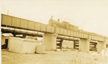
Photograph - Bridge Bairnsdale, 1926 c
... railway bridge with road bridge visible behind at Bairnsdale... train going over railway bridge with road bridge visible behind ...Photograph taken from Bairnsdale wharf just downstream from bridge. Train heading back to Bairnsdale from Bruthen OrbostBlack and white photograph of steam train going over railway bridge with road bridge visible behind at Bairnsdale Victoria waterways, bridges, transport -
 Whitehorse Historical Society Inc.
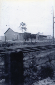
Photograph, Tunstall Hall
... of the railway line in Springvale Road....Whitehorse Historical Society Inc. 2-10 Deep Creek Road ...Series of photographs loaned for copying by Robert Collier through Keith Rooney. Photographs have been scanned by Ted Arrowsmith at 300dpi as a 'tiff' and burnt onto a CD Rom. copies of photographs were produced from the CD Rom for inclusion in the album.Black and white photograph of Tunstall Hall north of the railway line in Springvale Road.tunstall hall, tunstall -
 Whitehorse Historical Society Inc.
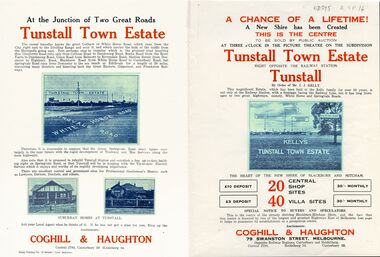
Legal record - Document, Tunstall Town Estate
... Road, Whitehorse Road, Railway Parade. Original in Haughton..., Whitehorse Road, Railway Parade. Land subdivision at Tunstall 1926 ...Land subdivision at Tunstall 1926 bounded by Springvale Road, Whitehorse Road, Railway Parade.Land subdivision at Tunstall 1926 bounded by Springvale Road, Whitehorse Road, Railway Parade. Original in Haughton Maps LaTrobe LibraryLand subdivision at Tunstall 1926 bounded by Springvale Road, Whitehorse Road, Railway Parade. land subdivision, springvale road, nunawading, railway parade, kelly, j, nunawading state school, no. 4190, shire of blackburn and mitcham, whitehorse road, silver grove, glendale street -
Port Melbourne Historical & Preservation Society
Letter - Proposed railway along Howe Parade to Webb Dock, 1973 - 1983
... Correspondence relating to proposed railway along Howe Road... relating to proposed railway along Howe Road to Webb Dock ...Correspondence relating to proposed railway along Howe Road to Webb Dock Photocopy of letter from V Doube to E R Meagherfrederick charles jackson, town clerks, local government - city of port melbourne, piers and wharves - webb dock, state government victoria, v j doube, e r meagher, gordon edwards -
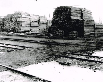 Otway Districts Historical Society
Photograph, Knox Collection, Beech Forest: timber stacks, 1906, 1906
... railway yard. Four roads passing. A goods shed in the background. ... railway yard. Four roads passing. A goods shed in the background ...Beech Forest was the principal despatch centre for split timber and mining laths in 1906, most of which was carried to the railway yards by bullock wagons, or a horse-hauled wooden tramline along the Olangolah Road to the east of the town. At the yards it awaited trans-shipment by rail.B/w. 190mm x 265mm. Timber stacked in the Beech Forest railway yard. Four roads passing. A goods shed in the background. beech forest; railways; -
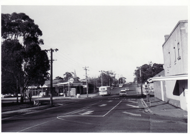
 Eltham District Historical Society Inc
Photograph, Looking east across Main Road from just north of intersection with Diamond Street, Eltham, February 1968, Feb 1968
... The watercourse passes under the road and railway... melbourne The watercourse passes under the road and railway ...The watercourse passes under the road and railway at this point. Significant flash flooding occurred along this water course on Christmas Day 2011 causing significant damage to the railway line and road and flooding of Judge Book Village. In February 1968 an unknown person took a series of photos from the Eltham Hotel at Pitt Street heading north along Main Road through the shopping centre to just north of Elsa Court covering the length of the section of Main Road which was duplicated shortly thereafter. Shows the condition and environment of the streesscape of Main Road, Eltham immediately prior to the duplication between Pitt Street and Elsa Court through the shopping centre. Also shows a number of shops and businesses that operated at that time.Black and white photographduplication, eltham, main road, diamond street, bible street reserve, watercourse, drainage -
 Ballarat Tramway Museum
Document - Photocopy, Neville Gower, "Mayor's Report 1960-1961", Jul. 1997
... pages covering trams, railways and road works. Photo of CRB... in the Ballarat Library. Two pages covering trams, railways and road works ...Photocopy of part of City of Ballarat's Mayor's Report for 1960 - 1961. Originals held in the Ballarat Library. Two pages covering trams, railways and road works. Photo of CRB resurfacing Bridge St. Images added 18-12-2016trams, tramways, city of ballaarat, trams, railways, civic history -
 Whitehorse Historical Society Inc.
Photograph, Blackburn War Memorial
... on the corner of Whitehorse & Railway Roads before being moved to Morton... stood on the corner of Whitehorse & Railway Roads before being ...Built after World War 1, the monument originally stood on the corner of Whitehorse & Railway Roads before being moved to Morton Park on 20th April 1969. The memorial was erected in memory of those from the district who were killed during WW1. Those who lost their lives in WW2 were added on the other side of the memorial as well as plaques commemorating later conflicts. The monument is a grey granite obelisk on a single stepped bluestone base on a concrete platform.Coloured photograph of a war memorial surrounded by flower gardens. Blackburn Tennis Club , rooms & courts on the left.blackburn war memorial, war memorials -
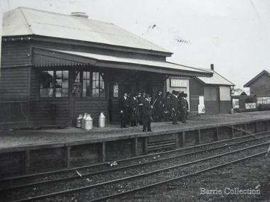
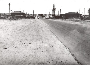 City of Kingston
Photograph - Black and white, c. 1950
... Black and white photograph of the railway crossing at South... and white photograph of the railway crossing at South Road ...This image shows a sealed road running along South Road, although with a wide gravel shoulder. The railway crossing gates were hand operated. This image is one of many in the collections that focuses on the railway. The development of the railway was crucial to the ongoing development of the area. Community life often sprang up along and beside the railway.Black and white photograph of the railway crossing at South Road, Moorabbin, viewed from Nepean Highway. Handwritten in blue ink on reverse: 217 Handwritten in red ink on reverse: 80%moorabbin, railway, railway crossing -
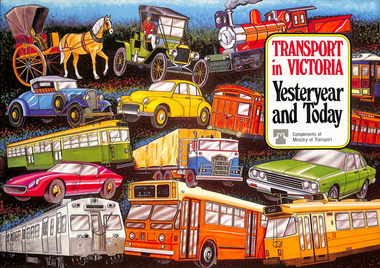 Melbourne Tram Museum
Book, Ministry of Transport, "Transport in Victoria - Yesteryear and Today", 1980
... of the state transport system, railways, roads, trams, Metropolitan... a short history of the state transport system, railways, roads ...Pamphlet or Book - 20 pages, full colour printed on gloss paper, centre stapled titled "Transport in Victoria - Yesteryear and Today", published by the Ministry of Transport giving an outline of Victoria's transport history from 1834. Provides a short history of the state transport system, railways, roads, trams, Metropolitan planning, the Bland report, social changes, the underground loop, transport interchanges, West Gate Bridge, Roads and Freeways, transport inquiry of 1980 and environmental changes resulting from motor cars. 2nd copy added 14-5-2016 from the estate of Charles Craig.trams, tramways, minister for transport, railways, trb, crb, murla, planning, history -
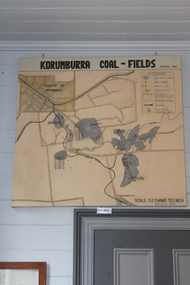 Coal Creek Community Park & Museum
Map of Korumburra's Coal, Korumburra Coal Fields, 1910
... 8513.1 - Map of coal fields, township, roads, creeks...Coal Creek Community Park & Museum 12 Silkstone Road ...8513.1 - Map of coal fields, township, roads, creeks, railways and boreholes in the Korumburra area. Painted on Canvas -
 Whitehorse Historical Society Inc.
Photograph, Blackburn Road, Blackburn, 1/06/1969 12:00:00 AM
... Black and white photo looking south along Blackburn Road... looking south along Blackburn Road from Railway gates in June 1969 ...Black and white photo looking south along Blackburn Road from Railway gates in June 1969.blackburn road, blackburn -
 Melbourne Tram Museum
Book, Victorian Parliament, "ACT 5977- discontinuance of service and dismantling of the St Kilda Bright Electric Railway which lies in the City of Brighton", Jun. 1956
... for the dismantling of the railway, road works, payments, including the date... for the dismantling of the railway, road works, payments, including the date ...Booklet - 8 pages, only 5 printed on, centre stapled - Victorian Government Act of Parliament, 1956 - "ACT 5977- discontinuance of service and dismantling of the St Kilda Bright Electric Railway which lies in the City of Brighton", dated 12 June 1956. Looks at the responsibility between the VR and City of Brighton for the dismantling of the railway, road works, payments, including the date for the discontinuance of the service. Second copy from the McComb Collection added 26-10-2016. Items 2062, 614 and 2063 within box 72.3 in a brown folder marked "Brighton Electric Street Railway" in ink on the front cover.Has the AETA stamp on the front cover and the library number "J3" in red ink., Second copy - has no stamps.trams, tramways, st kilda brighton, victorian railways, closure, dismantling, city of brighton, road works -
Port Melbourne Historical & Preservation Society
Plan - Proposed bridge under Hobsons Bay railway at Clarendon Street, Emerald Hill, 1854 - 1884
... Plan of proposed bridge under Hobson's Bay Railway..., Emerald Hill, affecting Sandridge railway and Sandridge Road ...Plan of proposed bridge under Hobson's Bay Railway at Clarendon Street, Emerald Hill, affecting Sandridge railway and Sandridge Road. Flood level re Sandridge line is shown.transport - railways, flood, emerald hill, town planning -
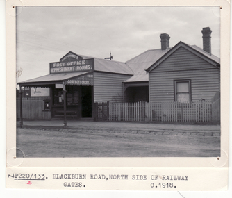 Whitehorse Historical Society Inc.
Photograph, H.W. Poyntz Tea Rooms Blackburn, C1918
... North side of Blackburn Road near Railway Gates... and Refreshment Rooms North side of Blackburn Road near Railway Gates H.W ...3 copies of H.W. Poyntz Post Office and Refreshment Rooms North side of Blackburn Road near Railway Gatespoyntz, henry -
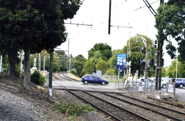 Whitehorse Historical Society Inc.
Photograph, Mitcham Railway line, 2012
... Coloured photograph of the railway line crossing Mitcham...Whitehorse Historical Society Inc. 2-10 Deep Creek Road ...Coloured photograph of the railway line crossing Mitcham Road. Blue car on road.Railway line heading east towards Ringwood.mitcham railway station, mitcham railway line, railways -
 Melton City Libraries
Photograph, Melton Train Station, Unknown
... The Melton South Railway Station, Brooklyn Road Originally... The Melton South Railway Station, Brooklyn Road Originally built ...The Melton South Railway Station, Brooklyn Road Originally built in the town of Leeor in 1898, the station building was relocated to Melton South in 1898. Black and white image of Melton Train Stationtransport, local architecture -
Whitehorse Historical Society Inc.
Article, Station on track, 2014
... Mitcham and Rooks Road railway line crossings are being... Mitcham and Rooks Road railway line crossings are being lowered ...Mitcham and Rooks Road railway line crossings are being lowered to eliminate gates, and a new station for Mitcham, with 800 parking places, is being built.Mitcham and Rooks Road railway line crossings are being lowered to eliminate gates, and a new station for Mitcham, with 800 parking places, is being built. The roads and station will be opened on 25 January 2014.Mitcham and Rooks Road railway line crossings are being lowered to eliminate gates, and a new station for Mitcham, with 800 parking places, is being built. mitcham railway station, mitcham railway crossing -
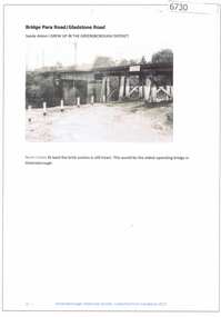 Greensborough Historical Society
Article and Photograph, Bridge at Para Road and Gladstone Road, 2018_
... Information and photograph about the railway bridge at Para... the railway bridge at Para Road and Gladstone Road Greensborough ...Information and photograph about the railway bridge at Para Road and Gladstone Road Greensborough.This photograph and text was copied from a Facebook site. Members are people who lived in the Greensborough area and share their reminiscences of the area with others. The site is administered by a GHS member but is not officially affiliated with the Society. Any information is the opinion of the contributor. Article and photograph sourced from social media.railway bridge greensborough, gladstone road briar hill, para road greensborough -
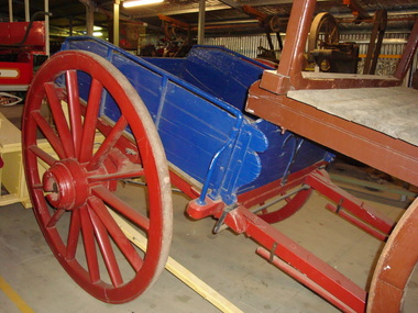 Maldon Vintage Machinery Museum Inc
Tip Dray, Late 19th century
... Used for carting rock to crushing batteries, road making...Maldon Vintage Machinery Museum Inc Vincents Road Maldon ...Used for carting rock to crushing batteries, road making, railway track building.Single horse drawn tip dray, restored by G & S Little in 1999. Made of timber with metal fittings and wheel rims. Enclosed sides with hinged front and rear panels. Chassis and wheels painted dark red, body in dark blue.Rectangular brass plaque on LHS looking forward detailing restoration and possible usage.transport ..... horse-drawn -
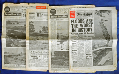 Orbost & District Historical Society
newspapers, February 1971
... was done to railway infrastructure, roads and farms. More... was done to railway infrastructure, roads and farms. More ...The 1971 floods at Orbost were the worst on record. At Jarrahmond the river rose to a height of 11 metres and on the flats spread to one and a half kilometres wide. Considerable damage was done to railway infrastructure, roads and farms. More information from the APRIL, 2008 newsletter by John Phillips. (see orbosthistory.com.au)These newspapers are contemporary records of a significant local event.Four newspapers and a set of clippings from various papers. They contain information and photographs pertaining to the 1971 floods in Orbost. 2557.1 is a Sun News Pictorial dated 8.2.1971. 2557.2 is a Snowy River Mail dated 10.2.1971. 2557.3 is an east Gippsland News dated 12.2.1971. 2557.4 is a Snowy River mail dated 12.2.1971 and 2557.5 is a collection of various clippings.floods-orbost-1971 newspaper snowy-river-mail sun-news-pictorial -
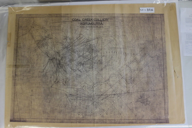 Coal Creek Community Park & Museum
Map of Mine and Details, Coal Creek Colliery Korumburra
... detailing number surface features such as topographic heights, roads... such as topographic heights, roads, railways, boreholes, etc. No Legend. Most ...8516.1 - Schematic/map of coal creek mine workings, also detailing number surface features such as topographic heights, roads, railways, boreholes, etc. No Legend. Most information seems to be printed, with topography drawn on. -
 Ballan Shire Historical Society
Map - Map. Korweinguboora, Department of Lands and Survey, Korweinguboora. Counties of Talbot and Grant
... A map of the Korweinguboora area showing roads, forests... goldfields A map of the Korweinguboora area showing roads, forests ...A map of the Korweinguboora area showing roads, forests, railway lines and properties with the owners names.The inclusion of the names of landowners is of significance and value to historians.A map of the Korweinguboora area showing land subdivisions and names of owners and other physical features. There is a scale in chains. No date is certain but it could be 1902. The map has been repaired with sellotape.There are various pencil annotations but the are difficult to read.talbot, moorarbool west, wombat, bullarto, korweinguboora, moorarbool east, dean, wombat state forest, barkstead -
 Eltham District Historical Society Inc
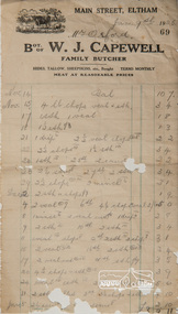
Invoice, Invoice No. 69, 9 Jan 1925 - Mr Orford; W.J. Capewell, Family Butcher, Main Street, Eltham, 09/01/1925
... W.J. Capewell operated a butcher shop near the Railway... melbourne W.J. Capewell operated a butcher shop near the Railway ...W.J. Capewell operated a butcher shop near the Railway Station on Main Road ElthamSnapshot of meat cuts and prices available in the mid 1920sDigital filew.j. capewell, butcher, invoice, orford, receipt -
 Eltham District Historical Society Inc
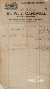
Invoice, Invoice No. 71, c. Jan 1925 - Mr Orford; W.J. Capewell, Family Butcher, Main Street, Eltham, 09/01/1925
... W.J. Capewell operated a butcher shop near the Railway... melbourne W.J. Capewell operated a butcher shop near the Railway ...W.J. Capewell operated a butcher shop near the Railway Station on Main Road ElthamSnapshot of meat cuts and prices available in the mid 1920sDigital filew.j. capewell, butcher, invoice, orford, receipt -
 Ringwood and District Historical Society
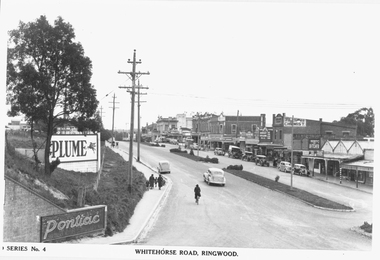
Photograph, Maroondah Highway Central, Ringwood. Whitehorse Road looking west from Warrandyte Road. c1930's
... Road railway bridge to Ringwood Street.... Road railway bridge to Ringwood Street. Black and white ...Black and white photograph (2 copies)Inscribed on photograph: "Series No 4. Whitehorse Road, Ringwood. Image shows shops on north side of road from Warrandyte Road railway bridge to Ringwood Street.