Showing 5882 items
matching residential
-
 Eltham District Historical Society Inc
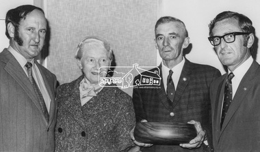
Photograph, Diamond Valley News, Shire of Eltham, Fire Prevention Week Winners Mrs. Toogood and Mr. MacMillan, 1971
Presentation being made to Shire of Eltham Fire Prevention Week 1971 Winners L-R: Mr. K. Griffith (Lower Yarra Group - Rural Fire Brigades), Mrs. Toogood - Winner Residential Section, Mr. MacMaillan - Winner Farm Section (Ex-Councillor of Shire of Eltham) and Cr. Dreverman - Shire PresidentThis photo forms part of a collection of photographs gathered by the Shire of Eltham for their centenary project book, "Pioneers and Painters: 100 years of the Shire of Eltham" by Alan Marshall (1971). The collection of over 500 images is held in partnership between Eltham District Historical Society and Yarra Plenty Regional Library (Eltham Library) and is now formally known as 'The Shire of Eltham Pioneers Photograph Collection.' It is significant in being the first community sourced collection representing the places and people of the Shire's first one hundred years.Digital image Print 10 x 16 cm (Held at Eltham Library)sepp, shire of eltham pioneers photograph collection, eltham, fire prevention week, mrs toogood, mr macmillan, k. griffith, cr. dreverman, rural fire brigade, councillors -
 Phillip Island and District Historical Society Inc.
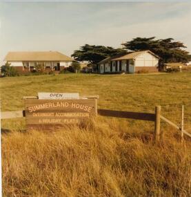
Photograph, John Cook, 1978-79
In 1927 Mr A. K. T. Sambell built a pier, planned and subdivided a residential estate, designed and built Summerland House, where ardent golfers after an enjoyable day on the course, could relax. Summerland House was built by local builder Mr Vic McRae. It attracted large numbers of professional people from Melbourne.Three photographs of Summerland Guesthouse, one of the first Guesthouses on the Island, situated above the site of the Penguin Parade. 81-87 Note sign: Open - overnight accommodation and holiday flats. 81-88 View of Summerland Guesthouse. Probably back view. Note elevated water tank. Car parked behind. 81-89 Another view of Summerland Guesthouse.coloured photograph, summerland guesthouse phillip island, akt sambell -
 Vision Australia
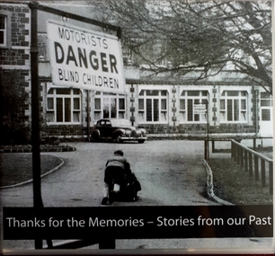
Audio - Sound recording, Thanks for the Memories - Stories from our Past, June 2008
On the 21st June 2008 Vision Australia hosted a farewell celebration at 557 St Kilda Road for people who attended the RVIB School and Residential Rehabilitation and Training Centre. This CD has been produced as a memento of this occasion. CD1 contains the official proceedings of the day. CD2 contains a compilation of interviews and memories that people shared on the day.21 sound files of official proceedings and interviewsroyal victorian institute for the blind, burwood school, employment -
 City of Kingston
Photograph - Black and white, 3 March 1954
Cheltenham and Moorabbin are suburbs within the City of Kingston that were originally established as rural market gardening communities The area is bordered by Highett and Mentone. The market gardens, farms and paddocks have gradually been sub-divided into housing and industrial estates. Highett is developed with residential homes but was also the site of major facilities such as the Highett Gas Works. This aerial image covers a diverse section of the City of Kingston, taking in the suburbs of Moorabbin, Cheltenham, Highett and Mentone Residential housing development is prominent along the Frankston Railway line and the area still retains extensive market gardens and paddocks yet to be converted to a large industrial and commercial zone.Aerial photograph of Mentone, Cheltenham and Moorabbin within the City of Kingston. The area depicted in this 1954 aerial view includes Warrigal Road and Centre Dandenong Road intersection (top left); Charman Road, Patty Street, Bourke Street, Collins Street Mentone (top right); Keys Road Moorabbin (bottom left); Bay Road, Cheltenham (bottom right), Friendship Square, Cheltenham Park, Victoria Golf Club and Jack Barker Oval are visible. Nepean Highway and the Frankston railway line run centrally through the image. Highett Gasworks is also evident.White handwriting and type [indecipherable]. White image of clockface White image of compass White type 42956 Black handwriting 3/3/54 Williams [indecipherable] Black pencil: S [arrow] Black ink: 3/3/1954cheltenham, moorabbin, mentone, highett, market gardens -
 Bendigo Historical Society Inc.
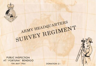
Document - ARMY HEADQUARTERS SURVEY REGIMENT, BENDIGO, 10 May, 1964
Army Headquarters Survey Regiment, Bendigo. Public Inspection at 'Fortuna', 10 May 1964. Donation 2/-. Includes photos of the Entrance Hall, Music Room and Villa. 3 army photos. In 1942 the mansion was occupied by the Australian Survey Corps and 'Fortuna' became the site of the base map production plant of the Australian Army for the remainder of the war years. During this period approximately sixteen million maps of Australian Territories and theatres of operation in the South West Pacific Area, were produced for use by the Allied Services. This function was continued as a peace time role in the post war years, and in 1951 ''Fortuna'' was purchased by the Commonwealth Government. As the largest unit of the Royal Australian Survey Corps, AHQ Survey Regiment carries out mapping in all parts of the Commonwealth and Territories including Papua and New Guinea. The Regiment is not only capable of doing its own field surveys but is responsible for the drawing and printing of map compilations from Royal Australian Survey Corps units in all States. . . . Includes map of grounds.buildings, residential, fortuna villa, army headquarters survey regiment, bendigo. public inspection at 'fortuna', 1964. photos of the entrance hall, music room and villa. mansion was occupied by australian survey corps and 'fortuna' site of the base map production plant australian army war. sixteen million maps australian territories and theatres of operation in the south west pacific area, were produced for use by the allied services. 1951 ''fortuna'' was purchased by the commonwealth government. royal australian survey corps, ahq survey regiment mapping commonwealth and territories including papua and new guinea. royal australian survey corps units in all states. map of grounds -
 Bendigo Historical Society Inc.
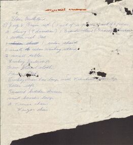
Document - LYDIA CHANCELLOR COLLECTION: DUDLEY HOUSE CONTENTS
(i) Three copies of a handwritten document detailing the contents of Dudley House. (ii) A torn piece of paper with blue handwriting and with the name Elaine Buckland at the top. It is followed by a list of objects and furniture.buildings, residential, dudley house, lydia chancellor, collection, buildings, dudley house, furniture, objects -
 Bendigo Historical Society Inc.
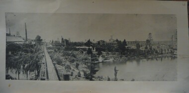
Photograph - FORTUNA COLLECTION: FORTUNA VILLA & 180 MINE, 1870
Composite Panoramic Black and White Photograph showing Fortuna Villa & surrounds with Lake in foregroundplace, building, residential, fortuna villa, mine, mining, fortuna, george lansell, christopher ballerstedt -
 Ballarat Heritage Services
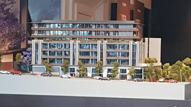
Digital photograph, Lisa Gervasoni, Derby Street redevelopment, 2017
building, derby street, kew, residential, apratment, construction, redevelopment, overdevelopment, model -
 Phillip Island and District Historical Society Inc.
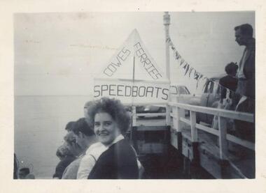
Photographs, 1940
Four of a collection of 33 photographs donated by Leonie Brennan. The collection belonged to Edward (Ted) Sands, hairdresser.Photograph 215-18. People on the Cowes Pier enjoying an event. A sign reads "Cowes - Ferries - Speedboats" and a string of bunting decorates the pier. There are also cars on the pier. Photograph 215-19. Phillip Island - San Remo Suspension Bridge viewed from Newhaven at very low tide. Photograph 215-20. A couple enjoying a picnic in a bush setting. Photograph 215-21. Three people sitting on the stone fence in front of the Isle of Wight Hotel. A large sign shows "ENTRANCE RESIDENTIAL & BAR - MELBOURNE BITTER"isle of wight hotel, isle of wight hotel phillip island, phillip island - suspension bridge, suspension bridge phillip island, cowes pier phillip island, mr edward (ted) sands, leonie brennan -
City of Kingston
Photograph - Colour, 29 January 1993
Bonbeach, Carrum and Patterson Lakes are suburbs in the City of Kingston. Bonbeach and Carrum were holiday destinations in early 20th century and over time the housing has converted to permanent residential structures. In Patterson Lakes, the area consists predominantly of newer housing developments and the tidal canal system which is accessible to many dwellings joins Port Phillip Bay.Bonbeach, Carrum and Patterson Lakes were previously part of the extensive Carrum Carrum Swamp. The area was once a source of fish and eels for the Mayone-Bulluk clan of the Bunurong people. Over time the area was drained and this allowed farming at Carrum and Bonbeach, although the area was prone to flooding. In the early 1920s and 30s the land was converted to residential dwellings. In 1973 investigations commenced nearby to Bonbeach and Carrum into the development of a unique residential area comprising canals and waterways. It was originally proposed to be known as "Gladesville". Circa 1974, the area was rezoned from rural to residential and named Patterson Lakes. Development has been continuous since the 1970s with staged construction of the waterways, residential housing, and supporting infrastructure and facilities.Laminated colour aerial photograph of the Bonbeach, Carrum and Patterson Lakes region within City of Kingston. This 1993 image includes Bonbeach High School prior to demolition, Bonbeach Primary School and Patterson River Golf Club. Sections of Patterson Lakes are not yet developed, including Rhode and Staten Islands. Long Island Point appears to be a recent development with many spare blocks and new houses under construction. The Patterson River marina is prominent and the river mouth as it meets Port Phillip Bay. The Carrum railway station is visible.Black type on white adhesive sticker: No. 6661 Black type on white adhesive sticker: 26E/6661, 29/1/93, 4.25 pm Black type on white adhesive sticker 29-1-93 Yellow circular adhesive stickerbonbeach, carrum, patterson lakes, patterson river, carrum carrum swamp, canals and waterways -
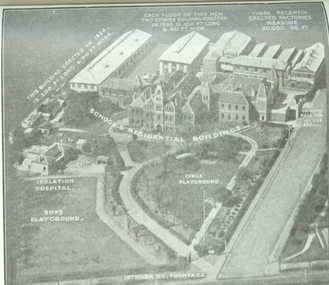 Vision Australia
Photograph - Image, Aerial view of the Royal Victorian Institute for the Blind grounds in St Kilda Road, 1927
Aerial photo of the RVIB St Kilda Road buildings and grounds, scanned from an unknown printed source. On the image are written descriptions of buildings, including the width and length of those erected in 1920's, the isolation hospital and the segregation of boys and girls playing areas. 1 scanned image of RVIB St Kilda Road from airGirls playground School & residential buildings Boys playground Isolation hospital This building, erected in 1926 - is 200 ft long & 40 ft wide Each floor of this new two storied building erected in 1926 is 100 ft long & 40 ft wide These recently erected factories measure 20,000 sq ft Ormond Hall for socials, etc. St Kilda Road frontageroyal victorian institute for the blind, buildings -
 Bendigo Historical Society Inc.
Document - RESEARCH PAPERS: HISTORY OF BENDIGO SALEYARDS, 1869
In 1859 6 acres were set aside for use as a cattle market and this was established between January and July 1861 in Charleston Road, Bendigo. By 1889 this had expanded to 13 acres. It initially included an abattoir, butchers, tanners and soap makers. In 1893 a rail spur was opened to prevent the need to drive cattle through residential areas. The yards moved to their current site at Huntly in 1997.HISTORY OF BENDIGO SALEYARDSbendigo saleyards, cattle market -
 Kew Historical Society Inc
Plan - Subdivision Plan, Harvest Home Estate, 1919
Pru Sanderson, in her groundbreaking ‘City of Kew Urban Conservation Study : Volume 2 - Development History’ (1988), summarised the periods of urban development and subdivisions of land in Kew. The periods that she identified included 1845-1880, 1880-1893, 1893-1921, 1921-1933, 1933-1943, and Post-War Development. These periods were selected as they represented periods of rapid growth or decline in urban development. An obvious starting point for Sanderson’s groupings involved population growth and the associated economic cycles. These cycles also highlighted urban expansion onto land that was predominantly rural, although in other cases it represented the decline and breakup of large estates. A number of the plans in the Kew Historical Society’s collection can also be found in other collections, such as those of the State Library of Victoria and the Boroondara Library Service. A number are however unique to the collection.The Kew Historical Society collection includes almost 100 subdivision plans pertaining to suburbs of the City of Melbourne. Most of these are of Kew, Kew East or Studley Park, although a smaller number are plans of Camberwell, Deepdene, Balwyn and Hawthorn. It is believed that the majority of the plans were gifted to the Society by persons connected with the real estate firm - J. R. Mathers and McMillan, 136 Cotham Road, Kew. The Plans in the collection are rarely in pristine form, being working plans on which the agent would write notes and record lots sold and the prices of these. The subdivision plans are historically significant examples of the growth of urban Melbourne from the beginning of the 20th Century up until the 1980s. A number of the plans are double-sided and often include a photograph on the reverse. A number of the latter are by noted photographers such as J.E. Barnes.The ‘Harvest Home Estate’ was advertised as being a subdivision in East Kew. Now, Campbell and Owen Streets on which the allotments were located are classed as being in Kew. The Estate included 11 residential allotments abutting the Outer Circle Railway line [at the end of Owen Street]. Understandably, the vendors focused on the availability of transport by tram, noting that the Estate was near the High Street tram terminus at the Harp of Erin. A small note on the subdivision advises that the Cotham Road tram was only 3 minutes away. The location – ‘The most elevated position in lovely Kew’ – was also promoted as an advantage.subdivision plans - east kew, harvest home estate -
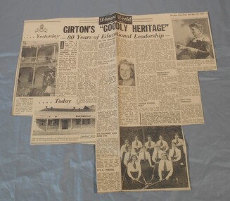 Bendigo Historical Society Inc.
Newspaper - Lydia Chancellor collection: Girton's "goodly heritage"
In 1884 Mrs Aherne and Mrs Mrs Willward founded Girton and named it after the first residential college for women at Cambridge University in England. It was controlled by the Anglican Church. By 1992 the church could no longer afford to run the school and announce its imminent closure. A group of parents and citizens formed the "Friends of Girton" and with massive plans and fund raising they managed to reopened the school in 1993 as an independent school with no gap in classes.Bendigo Advertiser from Saturday March 28, 1964. Girton's "goodly heritage" 80 years of educational leadership.girton, education -
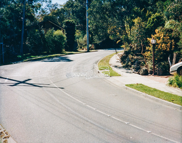
 Eltham District Historical Society Inc
Photograph - Colour Print, Eltham Shire Council, Unidentified road, Eltham district, c.Oct. 1987
Date based on other similar display panels visible in images of the Shire of Eltham display at the Eltham Community Festival, 7 November 1987. 20 x 25 cm Shire of Eltham Engineering Department Providing the resources to undertake • Survey, design, consultation • Road construction and maintenance • Bridge construction and maintenance • Street sweeping • Drain and pit cleaning • Traffic engineering installation and maintenance • Garbage collection • Tip management, land reclamation and beautification • Maintenance of community buildings • Provision of community and recreation facilitiesunidentified, display panel, eltham festival, footpaths and gutters, infrastructure, residential, roads, shire of eltham, streets, 1987 -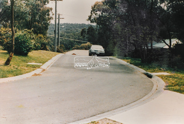
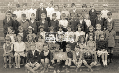 Eltham District Historical Society Inc
Photograph, Grade IIB, possibly Yarra Park State School No. 1406, East Melbourne, c.1930s
Unidentified school and students (not Eltham State School No. 209). Possibly Yarra Park State School No. 1406 (similar brickwork in backdrop to other photos (1928) in collection of a family that moved to Research. Yarra Park State School No.1406 (also known as Yarra Mews) was located at 1055 Punt Road, East Melbourne. It was built 1874 - 1877. Its current use is residential appartments. It is listed in the Victorian Heritage Database. Reproduction colour print of black and white printyarra park state school no. 1406, schools, yarra park, yarra mews, class photo, east melbourne, state school no. 1406 -
Dutch Australian Heritage Centre Victoria
Set of 3 Kitchen Canisters, DRU Holland (Diepenbrock & Reigers of Ulft, Holland), 20th century
Ulft consists of three hamlets: Ulft, Oer and De Pol. Oer is the northern part of Ulft and is called Oer because of the iron in the earth, which is called IJzeroer in Dutch. The DRU, an iron foundry, was located in Ulft. DRU moved to Duiven in 1999 and may be found at the Rijksweg A12. The Ulft site is still called "De Smeltkroes", a reference to the historic foundry, but is being converted to residential accommodation on top of a shopping centrum.Such sets of 3 canisters (coffee, tea and sugar) were commonly to be found on a shelf in Dutch kitchens. 5874 (a,b,c,d,e,f) Three (3) near-identical lidded enamelled steel cylindrical canisters, green on the outside and white on the inside. The lids are of black bakelite.KOFFIE, THEE, SUIKER (coffee, tea, sugar)kitchen, coffee, tea, sugar -
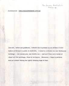 Robin Boyd Foundation
Document - Manuscript, Robin Boyd, Architecture: The Schizophrenic Style, 1971
Boyd proposes to apply art criticism techniques to architecture; claims architectural criticism in Australia is "all but dead" because of the 'schizophrenic nature of architecture" (i.e. building a socio-economic object as well as art). Boyd compares Kevin Borland's design of The Legend restaurant (Lonsdale St) with a recently designed residential apartment block (15 Collins St); claims that both are schizophrenic but The Legend is masterfully so whereas the apartments are aesthetically lacking.Original manuscript of an article published as ‘The schizophrenic style’ in "The Sunday Australian", 14.3.1971Typewritten (c copy), quarto, 11 pagesTop of page 1 handwritten where and when published. The last page credits photographer Mark Strizic, so images may have been attached.architectural criticism, art criticism, melbourne architecture, the legend restaurant, lonsdale st, leonard french, legend milk bar, tivoli theatre, clement meadmore, kevin borland, colonial architecture, 15 collins st, robin boyd, manuscript -
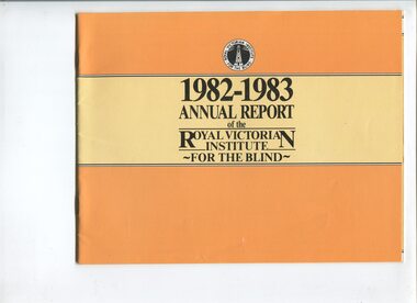 Vision Australia
Administrative record - Text, Royal Victorian Institute for the Blind annual report 1982-1983, 1982-1983
Activities in annual report include: retirement of Ralph Lightfoot, appointment of Frances Warren, opening of Wangaratta regional office, family group home in second year providing home environment for three children, establishment of self contained flat within residential services at Burwood, bushfires threatened but did not destroy Wahpeton at Romsey and ski lodge at Mt Baw Baw, and support from hotels through 80 Lucky Envelope machines.1 volume of printed material with imagesannual report, royal victorian institute for the blind -
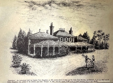 Melton City Libraries
Drawing, Eynesbury, Unknown
"Eynesbury, Eynesbury Road was one of four properties into which Simon Staughton’s Exford station, established in 1841, was subdivided for his sons after his death in 1863. The Eynesbury station of approximately 20,000 acres was inherited by his second son, Samuel Thomas Staughton. Eynesbury remained unsubdivided until redevelopment for residential purposes commenced in the early 2000s, at which time it was the largest pastoral property within 300 kilometres of Melbourne". Detailed sketch of the Eynesbury propertylocal architecture, local identities -
 Eltham District Historical Society Inc
Photograph - Colour Print, Belle Vue, Livingstone Road, Eltham, c.2015
Belle Vue property in Livingstone Road, Eltham was once owned by Society member Jo McCormick. Jo was a valued member of our committee and dear friend of many of our members until her death in 2009. Belle Vue is the farmhouse of a property that is now a significant part of suburban Eltham, just a short distance north of the town centre. Originally purchased by pioneer Eltham farmer Henry Stooke, the present-day old farmhouse sits within an extensive suburban residential area. The history of the property is largely based on a heritage assessment prepared by consultant Lorraine Huddle for Nillumbik Shire Council. Additional information from our Society records reveals Belle Vue farm comprised about 56 ha (140 acres) extending northerly from the northern boundary of Holloway’s 1851 Little Eltham subdivision. On the present day map the southern boundary was just north of Elsa Court and Grove Street. The western boundary was the Diamond Creek and extended northerly to Main Road where it turns easterly towards Research. It was traversed by the main road to Kangaroo Ground and beyond and from 1912 by the railway to Hurstbridge. From 1895 the farm was owned by William Williams and his wife Mary Ann. In 1914 -15 they built a new house now known as Belle Vue. They sold the land in 1920 and residential subdivision began soon after that. Belle Vue remains today on a substantially subdivided and very much reduced size residential lot in Livingstone Road. The house and many old trees on the site were subject to a heritage overlay under the Nillumbik Planning Scheme. Despite that overlay, the development and subdivision of the original land resulted in most of the heritage listed trees being removed. belle vue, eltham, livingstone road -
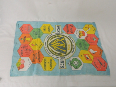 Kiewa Valley Historical Society
Towel Tea CWA, circa mid to late 1900's
This tea towel was manufactured in 1978 in Ireland and shipped to Australia. This was in a period when the C.W.A. was the major women's organisation which had the greatest influence amongst rural women (especially in isolated areas). This was a period when broad based communications were mainly by radio,women orientated magazines and the telephone. The relay of television to "remote" rural areas was not yet established. The CWA was therefore a very important organisation that catered exclusively to women's needs. The C.W.A. motto "Honour our God, Loyalty to the throne, Service to the country, Through country women, For country women, By country women." The atmosphere was one of "sisterhood" and covered nearly all the needs of rural based women. This one organisation incorporated knowledge and learning targeting women who physically may be isolated but not mentally. On the tea towel are portrayed all the activities that would be beneficial to rural women.This tea towel with its respective motifs is very significant to the Kiewa Valley as it related especially to women who felt the limitations of social interactions within a rural area. This tea towel represents a era where communications was relatively based on radio, magazines, books and limited telephone access. Within these restrictive interactive communication levels, the isolation of a "back o' Bourke" location applied tremendous mental fatigue on women more than on men.This CWA Victoria Golden Jubilee (1928-1978) tea towel is made from Irish flax at the Blackstaff Flax Spinning and Weaving factory. It is therefore of high quality and very durable. The major colours projecting from a light blue background are red, yellow, green, orange and black. The motives portrayed the activities of the CWA in 1978. These activities are embroidery, crocheting, dress making, knitting, cooking, art, macrame, drama, music, patchwork, toy making and community relief, pennies for friendship, emergency relief and welfare, residential club flats, the thanks giving and Papua New Guinea.The main or central theme of this tea towel is presented in the central area within three rings. "1928" on the left and "1978" on the right. On the top part "GOLDEN JUBILEE" and at the bottom "COUNTRY WOMEN'S ASSOCIATION OF VICTORIA" There are various shapes representing the activities listed above.cwa promotional material, cwa golden jubilee, women only organisations, country women's association -
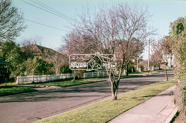 Eltham District Historical Society Inc
Slide, Pryor Street, Eltham, 25 Jul 1973
Looking east across Pryor Street towards the Eltham Police Station. The Police purchased the residence at 23 Pryor Street in 1959 to move from the old town centre of the late 1800s to be closer to the new town centre that shifted as a result of the railway opening in 1901. The residential house was renovated to Police requirements and operations commenced from this location in 1961. Diretly opposite and to the left of the Police Station is now a busy shopping centre car park.35 mm colour positive transparency Mount - Agfacolor Service (Blue)eltham, eltham police station, pryor street, streets, houses -
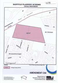 Greensborough Historical Society
Map, Saxam Heritage Overlay, 2011_
"Saxam" was the home of the Kaye family (1886-1888) then William Santon, a former councillor and Mayor of Heidelberg. Saxam Homestead is a distinctive and substantial timber homestead built in the late 1880s as one of the notable rural properties in the St Helena area. In 2014 the house still stands but is in poor condition with most interior features removed. The site had a heritage overlay as shown. The overlay was reduced in 2014 to protect the house while allowing residential development on the site.Saxam is one of the only remaining farmhouses in the Greensborough area.Copy of map and planning scheme.saxam -
 St Kilda Historical Society
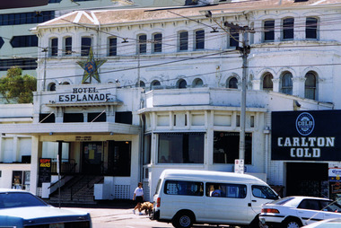
Photograph, Hotel Esplanade
Formerly New Bath & Criterion, built in 1856. New Bath demolished in the 1860s. A new hotel was built in 1878 and altered in 1921, when it changed hands and an entertainment venue was incorporated into the former exclusively residential building. Famed for live music, it is one of the earliest, largest and most prominent 19th-century resort hotels in Victoria. It has been altered many times since and this image predates extensive renovations and restoration work in 2018.colour photographst kilda, esplanade hotel, hotel esplanade, the espy, the esplanade -
 Melbourne Tram Museum
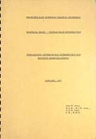
Document - Report, John Knee, "Warragul Road - Toorak Road Intersection", Jan. 1977
Report - "proposed East Burwood Tramway Extension - Warragul Road - Toorak Road Intersection - Preliminary Appreciation intersection and shopping redevelopment - Jan. 1977". Prepared by John W Knee for the MMTB and others. Looks at the intersection, how the shopping centre could be accessed, possible Mall development, residential issues, passenger facilities and pedestrian capacity. Includes a number of possible access routes for the area. None were applied when the tram line was extended.Yields information about a consideration for the extension of the Toorak Road line to East Burwood in 1977.Comb bound report with clear plastic covers, brown covers, 17 A4 pagesmmtb, east burwood, toorak road, warragul road, new tramways, john knee -
 Eltham District Historical Society Inc
Photograph, Liz Pidgeon, Heritage Excursion; East of Eltham, 6 Sep 2014, 20 May 2017
Newsletter No. 218, September 2014 September Excursion - East of Eltham Walk In Newsletter No. 197, March 2011, there was a brief history of Crown Allotment 15 Section 5 Parish of Nillumbik (CA 15) a parcel of land of a quarter of a square mile extending from Eucalyptus Road to Reynolds Road at the eastern extremity of Eltham. From the 1940s it was known as Stokes orchard. In later years it has been subdivided for residential purposes but leaving significant areas as power line and water supply reserves and bushland reserves that are habitat for the threatened For our excursion on 6th September we intend to walk through CA 15 to a bushland reserve east of Reynolds Road. The walk will traverse the boundary between suburban Eltham and the non-urban areas to the south and east. This is a pleasant walk through residential areas and bushland. Along the way we will discuss the early and more recent history of CA 15 as well as local natural history and geology. This walk is about 3.5 km in length and will take 2 to 2.5 hours. It will start at 2pm at the corner of Eucalyptus Road, Pitt Street and Nyora Road.Born Digitaleltham east, eltham district historical society, heritage excursion, activities, nyora road, reynolds road, gum tree road reserve, diosma road, stokes orchard, eucalyptus road -
 Eltham District Historical Society Inc
Photograph, Liz Pidgeon, Heritage Excursion; East of Eltham, 6 Sep 2014, 20 May 2017
Newsletter No. 218, September 2014 September Excursion - East of Eltham Walk In Newsletter No. 197, March 2011, there was a brief history of Crown Allotment 15 Section 5 Parish of Nillumbik (CA 15) a parcel of land of a quarter of a square mile extending from Eucalyptus Road to Reynolds Road at the eastern extremity of Eltham. From the 1940s it was known as Stokes orchard. In later years it has been subdivided for residential purposes but leaving significant areas as power line and water supply reserves and bushland reserves that are habitat for the threatened For our excursion on 6th September we intend to walk through CA 15 to a bushland reserve east of Reynolds Road. The walk will traverse the boundary between suburban Eltham and the non-urban areas to the south and east. This is a pleasant walk through residential areas and bushland. Along the way we will discuss the early and more recent history of CA 15 as well as local natural history and geology. This walk is about 3.5 km in length and will take 2 to 2.5 hours. It will start at 2pm at the corner of Eucalyptus Road, Pitt Street and Nyora Road.Born Digitaleltham east, eltham district historical society, heritage excursion, activities, nyora road, reynolds road, gum tree road reserve, diosma road, stokes orchard, eucalyptus road