Showing 1762 items
matching settlements
-
 Phillip Island and District Historical Society Inc.
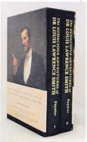
Book, John Poynter, The Audacious Adventures of Dr Louis Lawrence Smith : 1830-1910, 2014
"L. L. Smith, medico, writer, publisher, politician, litigant, showman, speculator, collector, vigneron, farmer, breeder and rider of racehorses, guiding hand for thirty year of Melbourne's great exhibition complex." - publisher's website. Instrumental in having Phillip island opened for selection in 1868.2 v. box : illustrations (some colour), facsimiles, protraits ; 24cm.Inscribed : To the Phillip Island Historical Society from Gillian and Norman Gengoult Smith, the grandson of Dr L. L. Smith whoe's [sic] 10 year battle in the Victorian Parliament for the cause was instrumental in having Phillip island opened for settlement Signed by the author : John Poynterjohn poynter, dr louis lawrence smith, the audacious adventures of dr louis lawrence smith -
 Phillip Island and District Historical Society Inc.
Newspaper clippings
Newspaper clipping on early history of San Remo and district, the naming of the township, San Remo Heights Estate Hall and the San Remo Post Office.Early history of San Remo, including its original settlement, surveying of the district, change of name from Griffiths Point proclaimed in the Victorian Government Gazette on 11th august, 1888. also early history of San Remo Heights Estate Hall and the San Remo Post Office. Includes a photograph of the township and fishing fleet probably taken from 1940 bridge.local history, documents, newspapers, san remo, buildings - historical, black & white newspaper clipping, san remo, post office, fishing fleet -
 Ringwood and District Historical Society
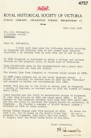
Letter, Letter from M. Greaves of the Royal Historical Society of Victoria to Mr J.K. McCaskill outlining a small number of aspects of early settlement of Ringwood, 16-Jul-58
Letter from M. Greaves of the Royal Historical Society of Victoria to Mr J.K. McCaskill outlining a small number of aspects of early settlement of Ringwood. +Additional Keywords: Lindsay, James / Pett, Joseph / Quigley, James / Wiggin, George Thomas / Cobb & Co / Railway / Lilydale / Kaolin discovery in Victoria / Antimony / Wood's Point Run / White Horse Hotel at Box Hill -
 Orbost & District Historical Society
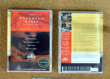
video, The Dreaming Reels, 1997
This disc was a project supported by the Festival of the Dreaming, a festival leading up to the 2000 Sydney Olympic Games.This disc is a significant research tool as it contains contemporary film of the early indigenous people of Australia.A video disc titled, The Dreaming Reels. it is a compilation of scenes from the Hadden expedition to the Torres Strait in 1898, Lake Tyers settlement, Northwest Scientific Exploration in the Kimberleys, the aboriginal camp at Orbost in 1921, the Douglas Wylie Expedition in 1926, Princess Charlotte Bay 1926-1927 and McRobertson's Expedition. It also contains footage from several Australian films depicting Aborigines. aboriginal-history dreaming -
 Bendigo Historical Society Inc.
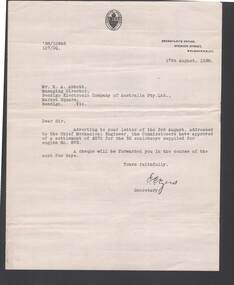
Document - BILL ASHMAN COLLECTION: CORRESPONDENCE
Letter, dated 17 August, 1938 from E. C. Eyers to Mr. H. A. Abbott. He refers to a previous letter, addressed to the Chief Mechanical Engineer, that the Commissioners had approved of a settlement of £270 for 52 scalebuoys supplied for engine No. 875 and that a cheque would be sent in the next few days. Letter has printed letter head with Victorian Railways logo at the top.sciences, instruments - general, scalebuoy, bill ashman collection - correspondence, victorian railways, h a abbott, bendigo electronic company of australia pty ltd, e c eyers -
 Victorian Aboriginal Corporation for Languages
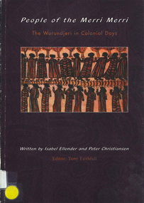
Book, Isabel Ellender et al, People of the Merri Merri : the Wurundjeri in colonial days, 2001
This book looks at the earliest years of contact between Aborigines and Europeans in the Melbourne area. The contact period saw the Wurundjerei-willam resisting, coping with and adapting to a new and alien culture. A degree of mutual respect seems to have existed, at least for a short time, of each other?s intentions. It appears that the settlement at Port Phillip did not encounter the degree of violence seen elsewhere.maps, b&w illustrations, colourwoiwurung, woi wurrung, wurundjeri, wurundjeri willam, merri merri, william thomas, -
Southern Sherbrooke Historical Society Inc.
Information Folder - geology of Dandenong Ranges
Information folder containing items pertaining to the geology of the Dandenong Ranges, including material prepared by Betty Hotchin for a talk to the Kallista Tourism course. Contents:-/typescript, re. basic features/photocopy, "The Dandenongs volcano and settlement in its great forest" by John Lundy-Clarke, published by Lilydale and District Historical Society/2 maps, Dandenong Ranges/List of reference materialdandenong ranges, geology of dandenong ranges -
 Ballarat Tramway Museum
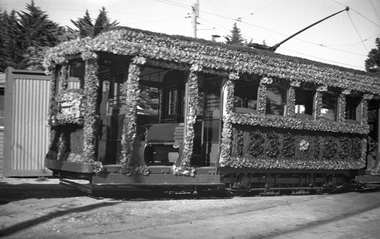
Negative, Wal Jack, Mar. 1938
Yields information about Ballarat 's 23, ex Adelaide when decorated for the 1938 state celebrations.Black and white Negative of a photograph of SEC Tram 23 decorated to celebrate the centenary of settlement in the Ballarat district in 1938 at the Wendouree Parade depot. Photo shows the interior exterior of the tram along with the flowers including the track brakes and trolley pole base. See also Reg Item 1031 for a similar image. Image i2 - hi res scan version of the negative.trams, tramways, depot, centenary, decorated trams, floral tram, tram 23 -
 Ballarat Tramway Museum
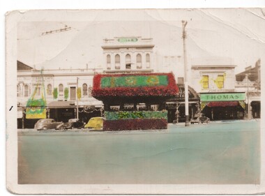
Photograph - coloured b/w photograph, 1938
Yields information about the shelter in Sturt at the intersection of Grenville St and its decorated in 1938 for the centenary of settlement in the Ballarat district.Hand coloured print of the Grenville and Sturt St shelter taken looking south, decorated with wax paper flowers for the centenary of settlement in Ballarat district in 1938. See also Reg Item 2917 for another photograph and newspaper details. Has the Spot Cafe, Britts Union Hotel Butlin's Cakes (?) and Thomas Jewellery which appears to have been decorated as well in background.On rear in ink "Tram Shelter Junction Sturt & Grenville Sts / Ballarat Centenary 1938"trams, tramways, grenville st, centenary, shelters, sturt st -
 Glenelg Shire Council Cultural Collection
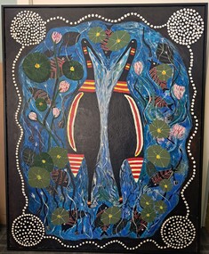
Painting, Elizabeth King, On the Edge, 2004
Exhibited by the artist at the Wood, Wine & Roses Festival, Heywood, 2004.Acrylic paint on canvas depicting birds and fish, water lilies and other vegetation, and stylised designs associated with early settlement of Aboriginal people in the Portland/Glenelg wetland area. Black painted border with white dot pathways, a circle of white dots in each of the four corners. Centre area in blues and greens featuring two birds, painted in black with red and ochre bandings.Front: nil -
 Melbourne Tram Museum
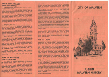
Pamphlet, Malvern Historical Society, "City of Malvern - A brief Malvern History", 10/03/1982 12:00:00 AM
Pamphlet - A4 sheet folded to DL, printed on orange paper titled "City of Malvern - A brief Malvern History", outlining the history of the City, including early settlers, churches, the Town Hall, settlement, the history of the name and street names, houses and hotels. Has photo of tram using a crossover in Glenferrie Road. Produced by the Malvern Historical Society. Two copies held.trams, tramways, sale of trams, seattle, w2 class -
Warrnambool and District Historical Society Inc.
Correspondence (Rose Park), 1940s
These are four letters and a document regarding the proposal in the 1940s by the Victorian Department of Lands and Survey to acquire sections of the property, Rose Park, to establish several Soldier Settlement farms. Rose Park, near Willatook, was owned by Stan Baulch (1897-1980), the son of Samuel and Eliza Baulch. Samuel Baulch had acquired the property of Dunmore, between Macarthur and Hawkesdale, in 1893 and Stan had inherited portion of this property after his father’s death. He named his portion Rose Park. The Soldier Settlement Commission wanted to acquire 1500 acres of Rose Park but Stan Baulch argued successfully that the management of his farm could not withstand the loss of so much land and eventually 300 acres of Rose Park land was sold for closer settlement. Stan Baulch was a prominent member of the Warrnambool and District Historical Society for many years and contributed many articles and booklets on local historical matters. This correspondence is of interest as an example of the establishment of Soldier Settlement farms in Victoria post World War Two and the difficulties faced by some property owners opposed to the acquisition of their land. These items will be useful for research. .1 A six-page letter written in pencil .2 A two page letter in black typing ( contents as in .1 above) .3 A one page letter, typed, with a handwritten signature .4 A sheet of paper containing a statement re purchase of land with some inserted handwritten material .5 A two page letter with handwritten material baulch family, western district, victoria, history of warrnambool -
 City of Moorabbin Historical Society (Operating the Box Cottage Museum)
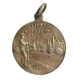
Badge - Centenary of Melbourne, c. 1935-35
White metal medal issued to commemorate Melbourne’s centenary 1934-35. This medal was given out to Victorian school children; 325,600 white metal medals were struck. The medal references Portland, the location of Victoria’s first settlement. The Henty brothers, entrepreneur farmers and whalers, established the state’s first permanent European settlement in Portland in 1834. Melbourne was established the following year by a party of settlers led by John Batman. In 1934, as Melbourne planned to celebrate the centenary of European settlement, it seemed to some that there was little to celebrate. The financial strains of the depression, unemployment and the scandal of the city’s slums all undercut claims of unbridled progress. Perhaps because of such troubles, the organisers of the centenary celebrations tried doubly hard to be positive. The themes of the celebrations were conservative, reflecting the desire of some Melburnians for security in troubled times. The widely promoted image of the ‘Garden City’ and ‘Queen City of the South’ emphasised the idea of Melbourne as a very British city. White metal badgeCentenary of Melbournemelbourne centenary, victorian school children -
 Halls Gap & Grampians Historical Society
Photograph - B/W, C 1898
The Jinker tracks were vitally important during the early years of European settlement. The first routes were known as bridle paths as they were only wide enough to allow the passage of a horse or a person on foot.Photo shows man with pack horse - large gum tree on right side of photoaccess routes, vehicle track, jinker track -
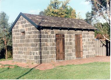 Hume City Civic Collection
Photograph
The Aitken Gap Gaol was originally constructed at the Gap Settlement on the Calder Highway in 1857 for the gold escorts. It was relocated to its present site outside the Sunbury Police Station in Macedon Street between 1989 and 1991.A coloured photograph of the relocated Aitken Gap Gaol. It has bluestone walls and a moss covered slate roof. with 2 solid stained wooden doors and blue painted wooden trims. A small cell window is on the side of the building and a paved brick area surrounds the gaol.aitken gap gaol, gap village, sunbury police station, george evans collection -
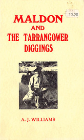 Lions Club of Maldon Inc.
Book, A Concise History of Maldon and the Tarrangower Diggings, 1979
Concise historical record of events rather than people. Contents include early settlement, gold discovery in 1853, early water problems, public institutions. Mention of Chinese on Tarrangower, and German and Italian settlers. Book of 86 Pagesmaldon, tarrangower, gold, victoria -
 Ringwood and District Historical Society
Book, James Rouget, Shire of Lilydale Past and Present 1837-1923, 1924
See also "Ringwood, Place of Many Eagles - Hugh Anderson" for additional information on the separation of the Borough of Ringwood from Shire of Lilydale (p.154).Short history of the Shire of Lilydale including Ringwood, Croydon and surrounding districts prior to separation from Lilydale of Borough of Ringwood in 1924.Preface extract: This small Volume contains a short history of the Shire of Lilydale, and is designed as a record covering the period especially relating to the early settlement. ... The information herein recorded has been obtained from official sources, historical records, first hand knowledge, and from the Pioneers themselves ... -
 Mt Dandenong & District Historical Society Inc.
Photograph, George Barber's Home Forest Edge after 1912 Looking South West, c1912
George Barber built a homestead later named Forest Edge on Barber's Road and lived there with his wife Sarah Ann (nee Richardson).Black and white photograph showing the side view of a house and three outbuildings. Reverse of photograph has handwritten description by John Lundy-Clarke.George Barber's home on bend of Barber's Road on Lot 25, Village Settlement. Showing passionfruit plantation. Buggy shed top right. Hay shed lower right. Stables, cart shed and men's quarters lower left about 1912. Photo copied by JLC in 1973.forest edge, george barber, sarah ann barber, kalorama, barber's road -
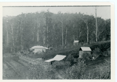
 Mt Dandenong & District Historical Society Inc.
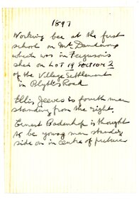
Photograph
The first Mt Dandenong School was established in William Ferguson's shed in 1897. On 11th May 1897 Head Teacher Ethel Gruber opened State School #3284. The locals lined the building and the Education Department supplied the windows. An average of 31 pupils attended. In 1901 the school transferred to a State owned building across the road.Black and white photograph showing a group of about 17 men sitting and standing beside a simple wooden structure. Handwritten inscription on reverse by John Lundy-Clarke1897 Working Bee at the first school on Mt Dandenong which was in Ferguson's shed on Lot 19 Section 2 of the Village Settlement in Blythes Road. Ellis Jeeves is fourth man standing from the right. Ernest Badenhop is thought to be the young man standing side on in centre of picture.ferguson, william ferguson, ethel gruber, ellis jeeves, ernest badenhop, school, state school, mt dandenong school -
Warrnambool and District Historical Society Inc.
Tools, Early 20th century
It is not known what sort of tool this is but it is possible that it is connected with rope-making or splicing in a maritime trade. As Warrnambool is a coastal city with a port that operated from the time of the first settlement (1847) to the 1940s it is possible that it has a local connection. This item has no known history and no known local provenance and so is retained for display purposes only at this stageThis is a wooden tool with a curved body tapering to a point. There is a small ridge near the thin end. maritime history, warrnambool, history of warrnambool -
 Ringwood and District Historical Society
Document, Short history of Nunawading, c 1950
This report covers some of the eastern suburbs of Melbourne from 1834 to 1890 (approx). The early settlement of Nunawading, agricultural development, industries, residential development, institutions and hotels. Place names , churches and schools are also included4 pages of typed notes of the short history of Nunawading between 1834 and 1890 (approx) +Additional Keywords: Holland, Clisby, Williams, Riles, Polak,Schwerkolt, Smith, Rooks, Boyle, Sergeant, Matters, Ainger, Slater -
 Sunbury Family History and Heritage Society Inc.
Photograph, c1940s
The people in the photograph are outside the Sir John Franklin Hotel which was one of the first hotels to be established in Sunbury in the early days of European settlement along Macedon Street. It continued to operate into the first half of the twentieth century.A non-digital black and white photograph with a cream border. of twenty two people and a dog standing and sitting outside a hotel building.sir john franklin hotel, hotels, sunbury -
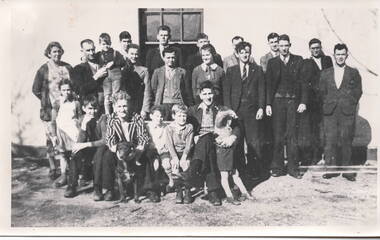
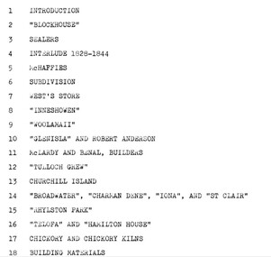 Phillip Island and District Historical Society Inc.
Book, EVANS, Maurice et al, An Architectural history of Phillip Island - to commemorate the centenary of open settlement on Phillip Island and Churchill Island from 1868 to 1968, 1967
RESEARCH ESSAY FOR HISTORY OF AUSTRALIAN ARCHITECTURE AND TO COMMEM0RATE THE CENTENARY OF OPEN SETTLEMENT ON PHILLIP ISLAND AND CHURCHILL ISLAND FROM 1868 TO 1968. BY MAURICE EVANS, NEIL EVANS, AND ROSALIE CARGILL, DEPARTMENT OF ARCHITECTURE, UNIVERSITY OF MELBOURNE.HistoricalStamped 'Phillip Island & District Historical Society'.phillip island, architectural history, churchill island, chicory kiln, guesthouses, houses, sealers, mchaffies, west's store, inneshowen, woolamaii, glen isla, mclardy and benal builders, tulloch grew, rhylston park, charmadene, iona, st clair, telopha, hamilton house -
 Glenelg Shire Council Cultural Collection
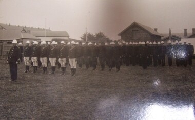
Postcard - Postcard - Police escort for Duke of Gloucester, Portland, 1934, 1934
HRH Prince Henry Duke of Gloucester came to Australia in late 1934, and to Victoria in time for the Centenary Celebrations (of pastoral settlement of the Port Phillip District, beginning with the Hentys settlement at Portland Bay on 19 November 1834). From Trove - 20 November 1934 Historic Portland was the scene yesterday of unprecedented celebrations when the Duke of Gloucester arrived from Tasmania to join in festivities marking the beginning of Victoria's second century. A great crowd estimated at more than 60,000 people watched the re-enactment of the landing of Edward Henty, Victoria's first permanent settler, on November 19, 1834.Black and white photograph rows of men in formal dress with white jodhpurs, dark coats and white hats. Five rows in all, with one man at the front. Buildings in the background. Police escort for Duke of Gloucester, Portland, 1934Front: (no inscriptions) Back: Police escort for Duke of Gloucester Portland 1934royal visit, 1934, duke of gloucester -
 Mt Dandenong & District Historical Society Inc.
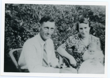
Photograph
The Wenborn family acquired Ferguson's Lot 19 of the Village Settlement where the original Mount Dandenong School was opened in a shed. WH Collom owned the land after Ferguson and then it passes to the Wenborns. This photograph shows Jim Wenborn with his wife Ivy and daughter Mary. The Wenborns had another daughter, Joan. Both children attended Mt Dandenong State School. John Lundy-Clarke grew up in the Kalorama/Mt Dandenong area and later in life (1972-74) began to write a comprehensive history of the area working from an original settlement map in an effort to cover all areas.Black and white photograph showing a man and woman seated in a garden. The woman is holding a small baby. Handwritten inscription on reverse by John Lundy-ClarkeJim Wenborn and family.wenborn, jim wenborn, ivy wenborn, mary wenborn, joan wenborn, ferguson, wh collom, mt dandenong school -
 Orbost & District Historical Society
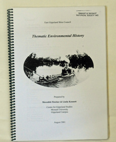
book, Thematic Environmental History, 2001
This booklet was prepared for the East Gippsland Shire Council in August 2001.A Thematic Environmental History identifies how key patterns of development have influenced the culture of the area and the natural and built environment. The document is not a social history but usually provides the context for future heritage studies and assessments and would provide input to the preparation of a Heritage Action Plan. This booklet prepared for the East Gippsland Shire councilA spiral bound book of 75 pp, titled Thematic Environmental History, prepared by Meredith Fletcher and Linda Kennett for the Centre for Gippsland Studies, Monash University, Gippsland Campus. On the front cover is a black and white drawing of a paddle steamer towing a barge along a river. It contains information on the discovery, settlement and land usage of East Gippsland as well as the development of transport, communication and cultural institutions. Copywright held by East Gippsland Shire Council and Department of Infrastructureenvironmental-study-east-gippsland -
 Phillip Island and District Historical Society Inc.
Photograph, 1960's
Donated by N.M. & J.D. Archibald, 1973 April.Black & White Photograph. Chicory Kiln. Kingston Gardens. Mr. V. Johnston. Built for Mr. de la Haye. Very early bricks. Thought to be from McHaffie Homestead and later from Innishowen. These bricks could have been originally from Corinella Settlement. Walls also show pieces of local rock, iron piping, bedsteads etc. Chicory Kiln Album.local history, photography, photographs, agriculture buildings, historic, chicory kiln, chicory industry, kingston gardens, v johnston, n & j archibald -
Glenelg Shire Council Cultural Collection
Book - Book Publication - 1984 150th Anniversary of Portland, 1984
A4 size publication 'Portland', made for 1984 150th Anniversary of Portland as Victoria's first permanent settlement. Covers cardboard, content, coloured photographs with black text. Front cover has photographs with black text. Front cover has photographs of Kingsley, historic painting, harbour at sunset, lifesavers, oil rig and yachts Henty Beach; with red border. Back Cover: Glenelg river -
 Warrnambool and District Historical Society Inc.
Document, Anna Mayo Bostock, 1940
This is a copy of the Will of Anna Mayo Bostock the wife of John Augustus Bostock a grazier from " Preston", Mansfield Victoria. It was made on 1940. Bostock family members have been important in the history of Warrnambool since the early days of settlement. This item is of minor importance as part of the Bostock collection held by the WDHS This is a A3 piece of paper folded in two to make four pages. It has black typing on the four pages. 1940 Will of Mrs A M. Bostock -
 Greensborough Historical Society
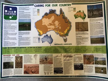
Poster, National Farmer's Federation et al, Caring for our Country, 1988c
A timeline of land management including indigenous care and the impact of European settlement from 1988 to 1987. Includes maps showing present land use and vegetation coverage in 1788. Prepared by Tim Gurry for the National Farmer’s FederationLaminated poster, printed in colour on one side.land management, farming, salinity