Showing 550 items matching "beach house"
-
 Surrey Hills Historical Society Collection
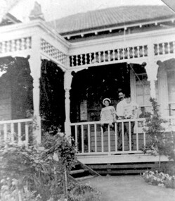
Photograph, Frank Cornell of 'Casallenroc,' 4-8 Lorne Parade
Frank and Blanche Cornell had their home built in 1904. Mr Cornell was a keen gardener, usually doing 2 hours’ work before going to work. He was a director of Buckley & Nunn, Bourke Street, having worked up from a position as shipping clerk. Frank was a great supporter of and worker for the Empire Day celebrations in the 1905-1911 period and also of the bowling club. He was also a keen photographer. Frank Cornell was first listed in Surrey Hills in 1906 at (6) Lorne Parade. In 1908 the listing gives his occupation as a clerk. He was born in 1869 in Richmond, Victoria and died 15 April 1917 in Surrey Hills from a stroke. His wife Blanche Annie Parsons Cornell (nee Bracher) was born in 1869 in Hokitika, New Zealand; she died on 21 January 1940. Children were: Gilbert Frank Cornell (b1894, Hawthorn; d1908, at Frankston beach, an accidental drowning) Ruth Amelia Cornell (b 1899, Kew; d 29 May 1977, Kew) Lorna Amy Cornell (b 1906, Surrey Hills; d unknown) Patience Blanche Cornell (b1907, Surrey Hills; d unknown). Frank and wife Blanche are buried in Box Hill Cemetery - CE-*-1058. Ruth Amelia married David Ellis, c1922 in Surrey Hills. David was a dentist who practised in Surrey Hills for many years. Patience (Pat) Blanche married Norman Henry Brewer (1893–1975) in 1931 in Surrey Hills.A black and white photograph of a man dressed in a 3 piece suit with flowers in his buttonhole, and a bow tie. He is also sporting a moustache.(mr) frank cornell, buckley and nunn, empire day celebrations, house names, lorne parade, surrey hills, (mrs) blanche amy parsons cornell, box hill cemetery, surrey hills bowling club, 'casallenroc' -
 Surrey Hills Historical Society Collection
Photograph, 'Casallenroc' 4-8 Lorne Pde, Surrey Hills
‘Casallenroc’, 4-8 Lorne Parade Built in 1904 and occupied from that date by Mr Frank & Mrs Blanche Cornell. Photo is of Mr Cornell with 2 of his children on the veranda. He was a keen gardener, usually doing 2 hours’ work before going to work. He was a director of Buckley & Nunn, having worked up from a position as shipping clerk. He died in 1917 at the age of 47 years from a stroke. Mrs Cornell had a large orchard. Children were Frank (who accidentally drowned at Frankston beach), Lorna, Patience (Mrs Brewer) and Ruth (wife of dentist, Dr David Ellis). A lemon scented gum in the garden was planted by the Cornells having had its trunk bent by the baby. It grew with a bent trunk. A black and white photograph of a man standing on the verandah with two children sitting on the railing. The verandah has some decorative fretwork around the verandah and decorative posts.house names, lorne parade, surrey hills, (mr) frank cornell, (miss) ruth cornell, (miss) pat cornell, 'casallenroc' -
 Vision Australia
Letter - Text, Letter to The Trustees, Clubhouse, Recreation grounds for the Blind, 16/5/1957
Letter to the Trustees outlining the outcomes of a recent meeting, as the minute book was unable to be located. Below is a summary of the letter. The death of W.H. Paterson is mentioned and the recommendation to the Committee that the clubhouse by named in his honour was unanimously accepted, however requires the agreement of the Trustees. The remainder of the letter covers the past five years. The Victorian Association of Blind Cricketers are requesting the erection of a shelter shed and scoring boxes. Complaints have been received about horses using the park, which have been passed to Malvern Council who advise they have also received similar complaints from the general public. A fence is required but a lack of finance has delayed this action. The Clubhouse is being used for more activities including a dance class, indoor bowling club, pottery and craft work, therefore a new switchboard and rewiring were completed. In October 1955, the State Government offered funding through local councils, however despite a representation to the Minister, the Malvern Council were not willing to expend funds to the Association as they had committed to build an Elderly Citizens Club. A large signboard was repainted and a new signboard erected at the front entrance, along with a light controlled by a clock. The Clubhouse has also been used one night per month by the local branch of the RSL and occasional use by the Teachers College for inter College sports. There has been cooperation with the L.T.A.V. (Lawn Tennis Association of Victoria) during tennis championships, and although the Committee recognise the need to do more with the area, the impending homes been built at Ballarat and Bendigo have been a limited factor. Signed by J.W. Wilson3 pages of type letter on letterheadAssociation for the Advancement of the Blind, Under the Distinguished Patronage of His Excellency the Governor of Victoria and Lady Brooks Founded 1895 (image of shining lantern) Incorporated 1944 10-12 Queen Street, Melbourne, C.1. Phone: MU 4189 MU 1955 Homes at: Brighton Beach Windsor Ballarat Bendigo On the left hand side of the page: President: Bruce Small, Esq. Vice President: Hubert Opperman, O.B.E. Treasurer: W.J.S. Horsfall, F.C.A. Secretary: J.W. Wilson Objects: To promote the welfare of the Blind intellectually, physically and socially. To grant financial assistance in cases of necessity. To provide Homes and Hostels of an undenominational character for the Blind. To visit the Blind. To care for the adult Blind, especially the aged and infirm. Donations will be subject to the concessional allowances provided by the Income Tax Act. At the base of the page: Homes and help for aged blindassociation for the advancement of the blind, john wilson, kooyong club house -
 Vision Australia
Letter - Text, Letter to Manager of the State Savings Bank of Victoria re: copy of agreement for Kooyong Club House, 1/3/1943
Carbon copy of a letter to State Savings Bank of Victoria accompanying copy of agreement between the Trustees of the Kooyong Club House and the Association for the Advancement of the Blind, requesting that the same is returned after perusal.1 single sheet of typed paperA female dressed in a loose gown holds a lantern from which the words 'Association', 'Advancement', 'of the Blind' and 'For the' are written in the rays coming from it. Below her feet are the words "Light of the Blind". 'Founded 1895' is written below the lantern, whilst in the top right hand corner is filled with: Homes at Brighton Beach Bendigo Hostels at South Yarra Windsor Offices: MU 4189 118 Queen Street, Melbourne C.1. All communications to be addressed to Secretary. Below the female figure, in the lower left hand side of the page: President: Miss Tilly Aston General Secretary: G.R. Fowler Objects: To promote the welfare of the Blind intellectually, physically and socially. To grant financial assistance in cases of necessity. To provide permanent or convalescent Homes and Hostels of an unsectarian character for the Blind. To visit the Blind.association for the advancement of the blind, kooyong club house -
 Port Fairy Historical Society Museum and Archives
Photograph - laminated copy
The people in this photograph had holidays at Seacombe House, 1926. they are Mrs Harry Pascall and Mary (Camperdown), Miss Anne Powell, Mrs O'Leary and Kath, Mrs Bill Flynn.Black and white photograph at the Entrance gate to South Beach with a lady and two children standing in the gateway in 1926south beach, entrance gate, james street, trees, path, road -
 Port Fairy Historical Society Museum and Archives
Photograph, Hugh Hanley /Port Fairy Gazette
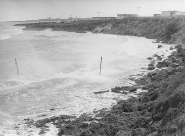
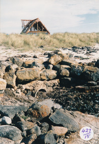
... South beach storm houses ocean sea South Beach 16/05/1975 storm ...South Beach 16/05/1975 stormBlack and white photograph of Storm waters lashing South BeachSouth Beach 16/05/1975 storm The Port Fairy Gazette Phone 14 Printers Publishers Stationerssouth beach, storm, houses, ocean, sea -
 Port Fairy Historical Society Museum and Archives
Photograph
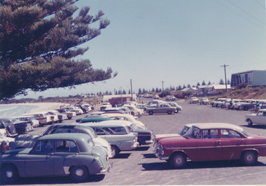
East Beach Car ParkColoured photograph East Beach car park around 1970’s with weatherboard house on righteast beach, car park, cars, half round shed -
 Port Fairy Historical Society Museum and Archives
Photograph
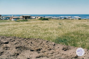
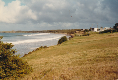
... Coloured photograph of Houses at South Beach between... beach development hill Coloured photograph of Houses at South ...South Beach Developement Coloured photograph of Houses at South Beach between grassland and seasouth beach, development, hill -
 Port Fairy Historical Society Museum and Archives
Photograph
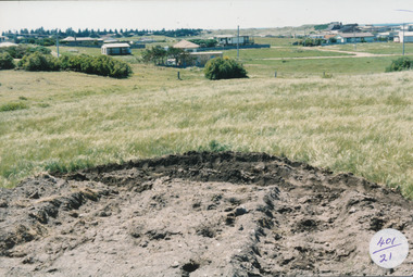
... beach development houses road making Coloured photograph ...South Beach Development Coloured photograph of Earthworks in foreground with some housing on the South beach estate in backgroundsouth beach, development, houses, road making -
 Port Fairy Historical Society Museum and Archives
Photograph
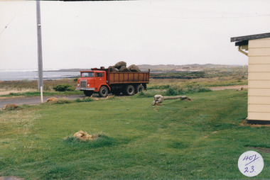
South Beach Development Coloured photograph of Tip truck with load of bluestone in foreground whale bone on a mound in front of house407/23 (Label has now been removed (2021)ocean drive, truck, bluestone, whale bone, south beach, development -
 Port Fairy Historical Society Museum and Archives
Photograph
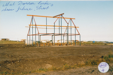
... beach development mal dora house Building jehu street Photograph ...South Beach Development south beach, development, mal dora, house, building, jehu street -
 Port Fairy Historical Society Museum and Archives
Photograph
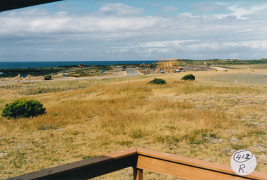
South Beach Development south beach, development, ocean drive, mal dorea, house building, road, street -
 Port Fairy Historical Society Museum and Archives
Photograph
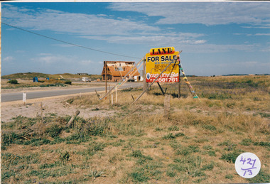
South Beach Development south beach, development, sale, sign, mal dora, house, building -
 Port Fairy Historical Society Museum and Archives
Photograph
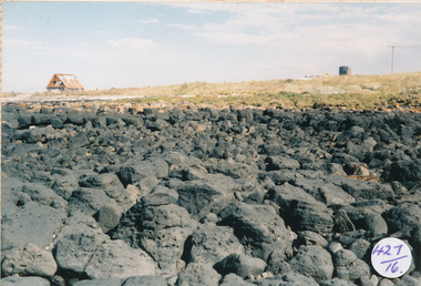
... looking from rocks to Mal Dorea’s house South beach development ...South Beach Development looking from rocks to Mal Dorea’s housesouth beach, development, rocks, bluestone, mal dorea, house, building -
 Port Fairy Historical Society Museum and Archives
Photograph
... house from the beach ... looking toward Mal Dorea’s new house from the beach south beach ...South Beach Development looking toward Mal Dorea’s new house from the beach Coloured photograph of rocks and drain on beach looking at unfinished A framed house in backgrounsouth beach, development, mal dorea, house, building, bluestone, beach -
 Port Fairy Historical Society Museum and Archives
Photograph - Lithograph
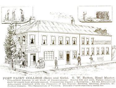
This card was probably used as an advertisement. (The Stag built 1848-1853.Land was purchased from Atkinson to build a licensed premises, it later became a boarding house also a boarding school now is used mainly as accommodation and also a Restaurant )Black and white photograph of a drawing of Seacombe House as Port Fairy College with large descriptionPort Fairy College (Boys and Girls) G.W.Ratten Headmaster. I qualified success in all kinds of examinations. Ninety five per cent passes obtained. Over 100 pupils already passed. Commercial classes a speciality. All the educational advantages combined with the pleasures of the seaside, bathing, shelling, beaches & c. Perfect climate. The Sanatorium of Victoria. Delicate pupils especially cared forhotel, stag, seacombe, inn, boarding school, sackville street, cox street -
Surrey Hills Historical Society Collection
Photograph, "Aberystwyth" 40 Wandsworth Road, Surrey Hills, 29 January 1998
Built about 1905 in the Federation style with ‘Queen Anne’ influence. An early owner was Lionel Jones, a journalist and later Eustace Coghill of the Coghill family. After other owners the house was sold and in 1998 removed on two semi-trailers believed to be heading for the San Remo area. The name Aberystwyth possibly come from an association with Wales. Although a thriving sea-side town in the summer, the historic town of Aberystwyth is better known as a university town and the centre of learning for Wales, as it is also home to the National Library of Wales and boasts the largest Arts Centre in Wales. The town is huddled between three hills and two beaches.A coloured photograph of a close-up of the verandah fretwork, the roof without the tiles and a chimney.wandsworth road, surrey hills, federation style, queen anne style, mr lionel jones, journalists, mr eustace coghill, aberystwyth, house names -
 University of Melbourne, Burnley Campus Archives
Photograph - Black and white print, Port Phillip Bay Beach, Unknown
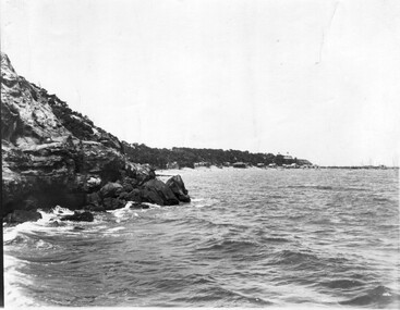
Black and white photograph. Port Phillip Bay beach, excursion. Rocky promontory with beach further on - bathing boxes seen in B91.427, houses and jetty on next point.port phillip bay beach, excursion, rocks -
 Port Fairy Historical Society Museum and Archives
Photograph
... 1983 East beach Groins houses marram grass dune 1983 Photograph ...East Beach looking South June 1983east beach, groins, houses, marram grass, dune, 1983 -
 Phillip Island Conservation Society Inc.
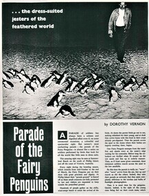
Work on paper - newspaper cutting photocopy, "...the dress-suited jesters of the feathered world/Parade of the Fairy Penguins", unknown
The general public was fascinated by the nightly 'Penguin Parade' on Phillip Island. Many articles have been written about the birds and the Penguin Parade attraction since the 1930s. So many people spent their summer holidays on Phillip Island in one of the many guest houses, then caravan parks and holiday homes and a visit to the Penguin Parade by them and their visitors was very common during their holidays. Articles tended to be a mix of basic penguin behavior information and anthropomorphic descriptions. Accompanying photographs were almost invariably taken by flashlight (now illegal), or of penguins taken from their burrows during daylight hours for photo opportunities. The article provides evidence of the level of knowledge about Phillip Island's Little/Fairy Penguins at this time. (approx 1960?)Photocopy of 2 page magazine article. Black print. Images poor quality due old photocopy.little penguins, fairy penguins, eudyptula minor, phillip island penguin parade, dorothy vernon, penguin rookery, penguin behaviour, phillip island tourist attractions -
 Phillip Island Conservation Society Inc.
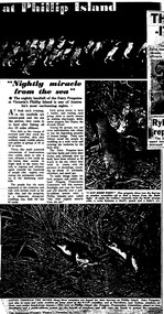
Work on paper - Photocopy of newspaper cutting, (part obscured) "at Phillip Island/Nightly Miracle/from the sea", November 20, 1957
The general public was fascinated by the nightly 'Penguin Parade' on Phillip Island. Many articles have been written about the birds and the Penguin Parade attraction since the 1930s. So many people spent their summer holidays on Phillip Island in one of the many guest houses, then caravan parks and holiday homes and a visit to the Penguin Parade by them and their visitors was very common during their holidays. Articles tended to be a mix of basic penguin behavior information and anthropomorphic descriptions. Accompanying photographs were almost invariably taken by flashlight (now illegal), or of penguins taken from their burrows during daylight hours for photo opportunities. This article, written in the 1950s, describes the management of the Penguin Parade at that time as being run by the Penguin Preservation Committee. This was before the Phillip Island Council took over running the Penguin Parade. The article provides evidence of the level of knowledge about Phillip Island's Little/Fairy Penguins at this time. (1957)single full-page magazine article, black ink on white paper. Photocopied from original, so photos appear as black and white.little penguins, fairy penguins, eudyptula minor, phillip island penguin parade, dorothy vernon, penguin rookery, penguin behaviour, phillip island tourist attractions -
 Phillip Island Conservation Society Inc.
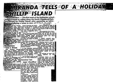
Work on paper - Photocopy of newspaper cutting, Herald and Weekly times, "MIRANDA TELLS OF A HOLIDAY ON/ PHILLIP ISLAND"
Miranda was a very popular journalist of this era, whose homely style appealed to many readers, especially women, her main audience in her writing. Here she talks about renting a new demonstration holiday home (probably a Coldon Home), which, although small, had a 'dream kitchen'. She describes the birds and walk through the wattle to the beach, but also the many blocks for sale and wonders what the island will be like in 10 years time from their visit. Her son drove them to Pyramid Rock where they almost got bogged on the road. They visit the usual spots, which she describes with a combination of curiosity and enjoyment. She also mentions another block fenced off on the main road which was a gift from the ratepayers of Phillip Island, and which the Young Farmers were to plant out for koala trees.This article is significant because thousands of Weekly Times newspaper readers read Miranda’s letter article without fail each edition. She describes renting a house for a holiday, which indicates the move away from family holidays in guest houses. She also describes some of the rough roads in parts of the island at the time. She concentrates on the island’s natural attractions rather than man- made tourist attractions, which is also significant in letting us see why people would visit Phillip Island in that era. Miranda also predicts the explosion of the holiday home owner market which took place soon after, and continues today though in a more controlled way.Photocopy of newspaper article cut out from full page. Cutting has three columns of text, no images. Black text on white paper. Dark areas due to poor photocopyingWEEKLY TIMES / 2/9/65phillip island, miranda, weekly times newspaper, holiday home, phillip island flora and fauna, pyramid rock, phillip island pengiun parade, young farmers, phillip island beaches, cuddly koala bears, phillip island housing estate land sales -
 Phillip Island Conservation Society Inc.
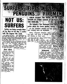
Work on paper - Photocopy of newspaper cutting, The Express, "SURFERS' FIRES KILL/ PENGUINS - FIREMEN//NOT US:/SURFERS"
Written during the 1960s when surfing was burgeoning across Australia’s coast and Phillip Island surf beaches had become extremely popular, few management strategies were in place to control interaction of the public with the delicate flora and fauna of the coastal environments. There were few good access tracks, car parks, bins, toilets etc at coastal/surfing hotspots around the Phillip Island coast. A number of management issues occurred with the influx of surfers. These included dune erosion caused by surfers climbing dunes to see the surf before going on the beach; informal parking on wildlife habitat; numerous access paths from wherever cars were parked down to the beach cutting through habitat; illegal camping on foreshores; illegal lighting of fires on beach and in dunes; surfers’ dogs let out of the car while surfers were out on the water. The dogs were uncontrolled. Certainly some surfers behaved responsibly, as is almost invariably the case these days. However, in that era of this article few people understood the delicate nature of the coastal environment and that it need to be protected through public education, infrastructure and enforcement of regulations. As now, most rural Fire services were run by dedicated volunteers who faced many challenges in their roles as Country Fire Authority firefighters. However, it was not uncommon for visitors and locals to also assist with fire-fighting efforts.The article is significant in containing quotes from both sides of the discussion who were directly involved in coastal fire incidents on Phillip Island in the 1960s. It also indicates the large number of surfers visiting Phillip Island beaches, the volunteer nature of the firefighting service and the extra challenges they faced on Phillip Island as a visitor destination. The anonymous university student surfer who is quoted, also describes possible causes of the fires, methods he and his fellow surfers used to extinguish the fires and raise the alarm, and the way they assisted the volunteer firefighters . The reference to him breaking into one of the Summerland housing estate holiday houses is also significant because that housing estate was purchased over 2 decades by successive Victorian governments to remove management issues caused to the wildlife habitat on Summerland Peninsula.Photocopy of newspaper cuttings including 2 related articles. Five columns of black text on white paper with one poorly reproduced photo bottom rightphillip island, cat bay, country fire authority, artie murdoch, alf towns, frank dixon, barry thompson, newhaven-san remo rural fire brigade, penguin parade, cowrie beach, surfers, coastal fires -
City of Kingston
Photograph - Colour, 31 January 1993
Patterson Lakes is a suburb in the City of Kingston that is built one kilometre upstream of the mouth of the Patterson River. The area is bordered by the Patterson River and Eel Race Drain which enters the Kananook Creek. The suburb consists predominantly of newer housing developments and the tidal canal system of the development joins Port Phillip Bay. Patterson Lakes and the Kananook Creek were previously part of the extensive Carrum Carrum Swamp. The area was once a source of fish and eels for the Mayone-Bulluk clan of the Bunurong people. Over time the area was drained and in 1973 investigations commenced into the development of a unique residential area that would be built adjacent to canals and waterways. It was originally proposed to be known as "Gladesville". The development would give the suburb's homeowners access to Port Phillip Bay "from their back door". Circa 1974, the area was rezoned from rural to residential and named Patterson Lakes. Development has been continuous since the 1970s with construction of residential housing, schools, shopping centres, marinas, a hotel and library.Laminated colour aerial photograph of the Carrum and Patterson Lakes region within City of Kingston. This 1993 image includes Patterson River Secondary College, Roy Dore Reserve, Kananook Creek and Nepean Highway. The railway line can be seen as it veers inland from Eel Race Road, Seaford. The section of Ocean Reef Drive and Palm Beach Drive in Patterson Lakes appears to be a recent development with many spare blocks and new houses under construction.Black typed lettering on white adhesive label: 31.1.93 Black typed lettering on white adhesive label: 27E/7140 31/1/93 12.55 pm Black typed lettering on white label: 7140 Yellow round adhesive label located on left sidepatterson lakes, seaford, kananook creek, carrum carrum swamp, canals and waterways -
City of Kingston
Photograph - Colour, c. 1993
Patterson Lakes is a suburb in the City of Kingston that is built one kilometre upstream of the mouth of the Patterson River. The area is bordered by the Patterson River and Eel Race Drain which enters the Kananook Creek. The suburb consists predominantly of newer housing developments and the tidal canal system of the development joins Port Phillip Bay.Patterson Lakes and the Kananook Creek were previously part of the extensive Carrum Carrum Swamp. The area was once a source of fish and eels for the Mayone-Bulluk clan of the Bunurong people. Over time the area was drained and in 1973 investigations commenced into the development of a unique residential area that would be built adjacent to canals and waterways. It was originally proposed to be known as "Gladesville". The development would give the suburb's homeowners access to Port Phillip Bay "from their back door". Circa 1974, the area was rezoned from rural to residential and named Patterson Lakes. Development has been continuous since the 1970s with construction of residential housing, schools, shopping centres, marinas, a hotel and library.Laminated colour aerial photograph of the Carrum and Patterson Lakes region within City of Kingston. This 1993 image includes Patterson River Secondary College, Roy Dore Reserve, Kananook Creek and Nepean Highway. The railway line can be seen as it veers inland from Eel Race Road, Seaford. The section of Palm Beach Drive, Curlew Point Drive, Snapper Point Drive, Clipper Island and Myola Street in Patterson Lakes appears to be a recent development with many spare blocks and new houses under construction.patterson lakes, seaford, kananook creek, carrum carrum swamp, canals and waterways -
City of Kingston
Photograph - Colour, 6 March 1993
Edithvale is a suburb in the City of Kingston. It is located between Aspendale and Chelsea on the Port Phillip Bay and built within remnant areas of the Carrum Carrum swamp. The foreshore precinct comprises a wide sandy beach, with low sand dunes and numerous historic boat sheds. The suburb consists of older style dwellings and former holiday houses, combined with mid-century housing and newer homes. The large blocks are increasingly subdivided and the existing dwellings demolished to accommodate units and townhouses, thus changing the landscape of the area and reducing the tree canopy.The beachside suburb of Edithvale was previously part of the extensive Carrum Carrum Swamp. The area was once a source of fish and eels for the Mayone-Bulluk clan of the Bunurong people. Over time the area was drained and predominantly devoted to dairy farming and holiday houses. The farms were gradually sold and subdivided with a large number of homes built after World War II and in the 1960s. Edithvale is mainly residential with a shopping strip along Nepean Highway but little significant industry was ever established in the area apart from a plaster works and confectionary factory, both now closed.Laminated aerial colour photograph of Edithvale as viewed from Alexandra Avenue in the north to Ella Grove Chelsea/Edithvale in the south. regents Park Aspendale can be seen in the top left. The area is built-up with residential housing and facilities including Edithvale Primary School, numerous churches and the Edithvale Railway station. Large sections depict the remnant Carrum Carrum swamp. Edithvale Common and the former "Duck Inn" (Melbourne Water/Friends of Edithvale Seaford Wetlands) can be seen. Edithvale Recreational reserve, the valodrome and Edithvale Public Golf Course are prominent. The image shows vacant land in the area now known as Aspendale Gardens and the newer residential section of Chelsea Heights is not developed. A bike path has been established to cover the secondary drain. The Golf Links Court residential development located off Hughes Avenue is a large vacant block.Black type on white adhesive label: 6-3-93 Black type on white adhesive label: 25/9211, 6/3/93, 11.20 am Black type on white adhesive label: 9211 Yellow circular adhesive sticker Black pencil: 9211 6-3-93 arrow pointing Nedthvale, carrum carrum swamp, aspendale, chelsea -
 Melbourne Legacy
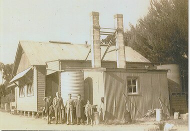
Photograph, Legacy Camp - John Bush photos, 1945
A rare photo of Legacy camp buildings at Stan Savige's property in Balnarring dated as 1945. Plus other photos from camps and beach trips. The source is not known but John Bush is in several photos and was presumably a junior legatee that became part of a leadership group, such as the Intermediate Legacy Club (ILC). They are a group of old sepia photos that have been reproduced.A record of the initial buildings built at Somers/Balnarring and outings provided for Junior Legatees organised by Legacy.Reproductions of sepia photos of John Bush in the 1940s.Labels on the back are handwritten in black pen. 02177.1 School house / Legacy Camps / 1945 02177.2 John Bush - 27 / Leader after WW2 02177.3 John Bush 02177.4 Digging trenches for rubbish / Somers 1947 02177.5 John Bush 1937junior legatee outing, camps, ilc, legacy somers camp -
 Melbourne Legacy
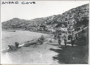
Photograph - Photo, Anzac Cove Gallipoli
A photo of the foreshore at Anzac Cove at Gallipoli in 1915. Was with 11 other photos of World War One that had been mounted on board for display at Legacy House at some stage. When they were taken off display they were put in the archive cabinets. The founding legatees all served in World War One so these photos would have been of significant places for them. (see 01888 to 01899)Photos from World War One that would have been significant to the founding legatees.Black and white photo of Anzac Cove beach at Gallipoli.gallipoli, world war one, soldiers -
 Melbourne Legacy
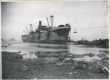
Photograph - Photo, Unloading supplies at Gallipoli
A photo of a boat called River Clyde unloading supplies at a beach presumed to be at the Gallipoli Peninsula. The book 'The Dardanelles' at 01886 has a photo of this boat at Seddul Bahr on page 8. Was with 11 other photos of World War One that had been mounted on board for display at Legacy House at some stage. When they were taken off display they were put in the archive cabinets. The founding legatees all served in World War One so these photos would have been of significant places for them. (see 01888 to 01899)Photos from World War One that would have been significant to the founding legatees.Black and white photo of a boat unloading at Gallipoli.gallipoli, world war one, ship -
 Melbourne Legacy
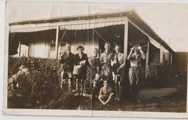
Photograph, Somers Camp, c1930
A black and white photo of a group of people holding camping items in the garden of a house. From other photos it appears to be a house often used for gatherings and may be on Stan Savige's Balnarring property. In the early years, Legacy organised outings to the property of Legacy founder, Legatee Stan Savige, who had a place in Balnarring close to the beach. Permanent camp buildings were built in 1930. In 1930 Lord Somers (Governor of Victoria) also started a camp at a nearby property and the area was renamed Somers. Legacy Somers Camps continued intermittently at Stan's property until it was decided in 1951 to make other arrangements for holidays. This photo was with a group of photos from around the 1930s from the early days of Legacy, including cricket team, football team, and camps at Balnarring/Somers (saved as 01915 to 01934). Mention has been found that the Savige holiday house at Balnarring was next to the campsite and sometimes provided support to the campers.A photo of a group of founding legatees or some of the first junior legatees. Legatee Savige was an important figure in Legacy's history and his property at Balnarring became very important for Legacy providing outings and camps for junior legatees.Black and white photo of a group of people at a house with camping items.Stamped 'Kodak print S 856' on back in grey ink.camp, junior legatee, legacy somers camp, savige property