Showing 517 items matching "bendigo cemeteries"
-
 Woodend RSL
Trunk, MID 20TH CENTURY
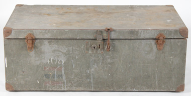
... of Bendigo” (AII.A.21. – cemetery/memorial reference number ...PERSONAL TRUNK OF CAPTAIN PETER SPENCER HAYMAN MCThis trunk was owned by Peter Spencer Hayman, who was regarded as a ‘Tobruk hero’. Hayman was the son of a Bank manager, Spencer Lewis Hayman and Agnes Lindsay Hayman. He was born in Exeter S.A. on 23/11/1916. He enlisted in the Australia Army at the age of 23 on 13/05/1940. His service number was VX14987. Hayman was a leader of a fighting patrol and served in multiple sites in Syria and Lybia. During his service in Lybia he lead his campaign through great difficulty and bravery in Tobruk. Although wounded by a grenade, he continued to lead his men into an enemy stronghold until resistance from a joining post compelled him to break off the engagement. He successfully brought his party back with very few casualties. Hayman was awarded the military cross in 1941. He was a Lieutenant when awarded, and was made captain of the 2/24 Australian Infantry Battalion shortly afterwards. He was killed in action on the 11/07/1942 and is buried in the El Alamein war cemetery. His father was flown to London to receive the medal. The inscription on his headstone reads; “Beloved son of Spencer and Agnes Hayman of Bendigo” (AII.A.21. – cemetery/memorial reference number). As an item owned by a ‘Tobruk hero ’ who was awarded the eminent military cross for bravery, ‘forceful leadership’ and ‘splendid courage’, this trunk is of national historic and social significance. It also has great interpretive capacity as an item that speaks of an impressive military story. Standard Army issue trunk. 88cm L x 51cm W x 33cm D. Dull grey in colour. There is provision for a tray to be fitted just under the lid. This tray was the same physical size as the trunk. The base has 2 cleats (88cm x 5.5cm), made of timber, to keep the trunk off the ground. An additional hasp and keeper have been fitted (near the centre of the lid) to hold it shut. The original type lock needed a key and were not very serviceable.P S H VX14987 408 -
 Bendigo Military Museum
Photograph - PHOTOGRAPH, PORTRAIT
Lance Corporal "Alfred Alexander Priest" No. 5162. Enlisted 31/12/15 into 6th Battalion, 16th Reinforcements. Embarked 1 April 1916 for England the 29 Aug 1916 to France. Hospitalised 8 Nov 1916 for trench foot and rejoined unit 11 Feb 1917. WIA 27 Feb 1917 GSW left forearm and rejoined 30 July 1917. WIA 4 Oct 1917 GSW left finger and rejoined 1 Jan 1918. WIA 16 May 1918 multiple gunshot wounds - died 27 May 1918. Buried at Boulogne Eastern Cemetery.Ful length portrait of Alfred Alexander Priest in full uniform of WW1 ANZAC Soldier, in sepia. Man standing in an outside setting, holding a cane.Front bottom right hand corner written "KALMA BENDIGO". Back top right corner written "Len's Uncle, Alfred Priest".ww1, 6th battalion, alfred alexander priest -
 Bendigo Historical Society Inc.
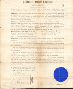
Document - BROCKLEY FAMILY DOCUMENTS: PERMIT TO DIG AND MAKE A GRAVE
Certificate from the Sandhurst Public Cemetery Back Creek for Robert Brockley of Bendigo to dig and make a grave according to the conditions. Dated 15th May 1891 and signed by Members of the Council and the Town Clerk. Has a blue seal in the bottom left corner.document, certificate, personal, sandhurst public cemetery back creek, robert brckley, j h abbott -
 Federation University Historical Collection
Map, Ballarat Goldfield, c1898
This map shows geological features, suggests the last basalt flow, and includes alotments and names of Mining Companies. Although this map has no date on it the Ballarat Industrial School is used for dating purposed. The Ballarat Industrial School ran from 1869-1879, but the term Ballarat Industrial School Reserve was still in use in 1898 and possibly beyond.Geological Map of Ballarat with 3 holes in the left hand side. The map indicates the position of Lake Wendouree, Township of Warrenheip, Ballarat East, Industrial School Reserve, Winters Swamp, Police Paddock, Wyndholm Premptive Right (Salton and Waldie), Black Hill, Vale Park Reserve, Pennyweight Hill, Little Bendigo, Black Swamp Lead, monte Christo Reef, Chinaman's Gully, Miners Rest, Pincotts Dam, Northumberland Gully. It also show the following goldmining companies: City of Ballarat, Kohinor, Hand and Band, Great North West, Northern Junction, Kneeshaw, Rossers Freehold, Silurial.ballarat, warrenheip, lake wendouree, ballarat east, winters swamp, winter swamp, wyndholm premptive right, cemetery, vale park reserve, little bendigo, kneeshaw co., industrial school reserve, kirks dam, pincotts dam, black hill, wombat hill, dead horse gully, miners rest, mt rowan, salton and waldie, rose hill co, great north west no 1, rose's freehold co, hand and band co, police reserve, police paddock, mount rowan, ballarat industrial school reserve, market reserve, winter's swamp, kneeshar co, monte cristo line of reef, chinaman's gully or black snake, milkmaid's gully, ballarat gold field, bakery hil lead, old gravel pits lead, golden point lead, eureka lead, miner's rest, yarrowee creek, leigh creek, black swamp lead, yorkshire reef, nil desperandum reef, cockatoo lead, hit or miss gully, herbert werner frederick de nully, pennyweight hill, esmond's lead, ash's lead, nightingale lead, john bull gully, gladstone reef, whitehorse reef, petticoat creek, pincott's dam, frenchman's gully, tim's crushing plant, jenkin's gully, california gully, drake's creek, sulton and waldie, ballarat undustrial school, ballarat & mariborough railway -
 Bendigo Historical Society Inc.
Document - RED RIBBON COLLECTION: DOCUMENT THE BENDIGO PETITION AND THE RED RIBBON MOVEMENT 1853
... Back Creek (Bendigo) Cemetery... City of Bendigo Back Creek (Bendigo) Cemetery White Hills ...In 1853, Bendigo Miners protested against the 30 shilling miners licence the had to pay the government. They wore red ribbons to show their protest and shopkeepers hung red ribbons outside their premises in support. Thousands of miners signed a petition to Governor LaTrobe to no avail. A protest gathering in Pall Mall marched to the Government camp on Camp Hill but this was a peaceful event again to no real avail.Typed notes on The Bendigo Petition and the Red Ribbon Movement. Amongst the petitioners were two women, Florence Foley and Sarah Williamson. Others include J H Abbott, Theodore Ballerstedt, Robert Benson, Captain Brown, W D C Denovan, William Froomes, Henry Holyoake, Doctor Jones, Frederick Ladbury and George Thomson. Also mentioned is how the petition was resolved. Further reading mentioned is: Frank Cusack's book 'A History of Bendigo entitled 'Red Ribbons in the Rain', and Geoff Hocking's book 'The Red Ribbon Rebellion - The Bendigo Petition, which contains names of those who signed the Petition. Written by the Bendigo Historical Society Inc.event, the bendigo petition and the red ribbon movement 1853, governor la trobe, florence foley, sarah williamson, j h abbott, theodore ballerstedt, robert benson, captain brown, w d c denovan, william froomes, henry holyoake, doctor jones, frederick ladbury, george thomson, george edward thomson, anti-license movement, sanders, william dixon campbell denovan, city of bendigo, back creek (bendigo) cemetery, white hills cemetery, joseph henry abbott, the diggers advocate, frank cusack, gold license fee, diggers' banner, william dexter, commissioner panton, commissioner wright, a history of bendigo, frank cusack, geoff hocking, the red ribbon rebellion - the bendigo petition, bendigo historical society inc -
 Bendigo Historical Society Inc.
Book - ALICE ABSALOM POSTCARD COLLECTION: ALBUM, 1905 - 1911
Postcard Album of Alice Absalom. Red book with painted red and blue flowers surrounding a stylized letter "P". on front cover. 13 postcards. 22 pages. 1408.1 - 1408.13. Inscribed inside front cover "From Mother. To Alice Wishing you many happy returns of the day. 1907". Alice Ann ABSALOM Born: Eaglehawk 1889; daughter of Ferdinand Henry Absalom & Sarah Ann Borseri Married: In Victoria in 1912, James Ernest Watson Lived: In 1912, Lester Street Eaglehawk; In 1963, Marong Died: Bendigo 8 February 1966 Buried: Eaglehawk Cemetery Postcards stored in Folder 87postcard, album -
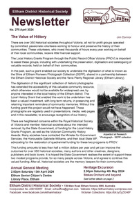 Eltham District Historical Society Inc
Journal - Newsletter, Newsletter, No. 275 April 2024
Contents: • The Value of History by Jim Connor • Next Meeting – Annual General Meeting - 2.00pm Saturday 13th April 2024 • May Excursion - Saturday 4th May – Stokes Orchard and beyond • Tourism to Eltham in the Early Days by Michael Aitken • Main Road Bridge by Peter Pidgeon • Where is Platy? By Jim Connor • Montsalvat People by Richard Pinn o Helen Skipper (1914-2000) o John Busst (1909-1971) • Harris – A Name for Three Wars by Terry Beaton • Notice: Annual General Meeting – Saturday 13th April 2024 • Eltham Cemetery Stories by Liz Pidgeon o Grace Mitchell, nee Wheildon, 1916-2011, Baker and Artist • Bendigo Bank, Community Bank The Shire of Eltham Historical Society was formed in October 1967. The first newsletter of the Society was issued May 1978 and has been published continuously ever since on a bi-monthly basis. With the cessation of the Shire of Eltham in late 1994, the Society's name was revised to Eltham District Historical Society and this name first appeared with issue No. 103, July 1995. The collection of the Society's newsletters provides a valuable resource on the history of the Society's activities, office bearers and committee members, guest speakers and subjects of historical interest pertinent to the former Shire of Eltham and the Eltham District.A4 newsletter distributed to members (Digital and A4 photocopy)newsletter, eltham district historical society -
 Linton and District Historical Society Inc
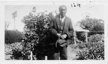
Photograph, Mr. Tom Andrews, 1936
Tom Andrews, whose father (also called Tom) was thought to have come to Linton from Jamaica, lived near the Battery Dam. Little is known of his life, other than that he attended the Methodist Church and was "a very respected citizen". In later life he lived at Boort. He is in a photograph of the Linton football team taken c.1915-1920. (Registration number 2019-247 - Mounted photograph 424.) Tom was a member of the Old Lintonian's Association and attended its reunions in the 1930s. Photograph is part of Old Lintonian collection; No. 124. He died at Bendigo in 1937 and is buried with other members of his family in Section 2 of the Linton cemetery.Black and white copy of original photograph of a man dressed in a suit and tie, and holding a hat.tom andrews, "black tom" -
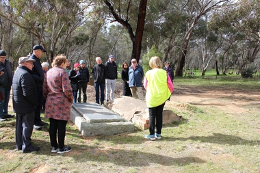 Bendigo Historical Society Inc.
Bendigo Historical Society Walking Tour of Axedale, 1st Sept 2024
Axedale is a town in Victoria, Australia. It is located on the McIvor Highway, in the City of Greater Bendigo, east of Bendigo. It was surveyed and proclaimed in 1861. At the 2021 census, Axedale had a population of 984. The town is nestled alongside the Campaspe River which feeds out of Lake Eppalock. It has a golf course, tennis courts, a school, a pub and a convenience store/petrol station. It lies between Heathcote and Bendigo.Forty Photos taken on the walking tour of Axedale by the Bendigo Historical society. Places visited included the Protestant and Catholic Cemeteries, the "Blue Stone House", the 150-year-old bridge over the Axe Creek on the Sugerloaf Road, the old Cobb and Co Stables, St Andrews Church and the Campaspe River Bridge.axedale, bendigo historical society walking tour, st andrews church axedale, axedale cemetery, axe creek bridge, campaspe, cobb and co stables axedale, blue stone house axedale -
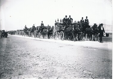 Bendigo Historical Society Inc.
Photograph - BASIL WATSON COLLECTION: PHOTOGRAPH OF BASIL WATSON'S FUNERAL PROCESSION
Black and white photograph of Basil Watson's funeral procession showing horse drawn hearse and following carriages. Inscription on back: ''Taken at East Melbourne 1919 en route to Brighton Cemetery. Photo taken by Ivy Harry - distant cousin of Basil Watson.person, individual, basil watson, photo taken by ivy harry - a distant cousin of basil watson. photo donated to royal historical society bendigo by wesley harry 26 december 1974. -
 Bendigo Historical Society Inc.
Document - Rocky Vale Beebe House, 2010 to 2015
The Beebe name was well-known in Bendigo in the last quarter of the 19th and the early part of the 20th centuries. From 1875, William Beebe senior, monumental mason, occupied a site in the centre on the city, in Mitchell Street opposite King Street. Death was more part of life in those days, and the Beebes were there to provide the burial monuments. Later, he took his sons into the business, which grew as Beebe and Son. Many examples of their work can be found in the local cemeteries. William Beebe senior (1830-1891) was born in Rutland, the smallest English county in 1830, to stonemason Chamberlain Beebe and Susannah Clements. William emigrated to Victoria in 1854 and after engaging on unknown works in Port Fairy, Dunkeld, and Melbourne arrived in Bendigo. His obituary records that he commenced work here on the site of the Bank of Australasia (opposite the Shamrock Hotel), which would have been no later than 1856. He took up a 13 acre selection on the site of Rocky Vale Villa in 1864 and continued to select or purchase further parcels of adjoining land until he owned some 150 acres, much of it unfit for cultivation. He was a keen gardener and had a garden and orchard around the house. William took over 20 years to build the two-story sandstone and granite house "Rocky Vale Villa". The house was constructed from sandstone sourced "from an adjacent ridge of rocks" (Bendigo Advertiser 28/9/1891). Granite from Harcourt was used for lintels and quoins. Not long before he died, William was still adding to the house. In the Codicil to his will, he states that "I have just built and completed two additional rooms to my Dwelling house situe at Inglewood Road aforesaid" (dated 19/9/1891). William died one week later on the 26th September 1891.Photographs and Historical Documents relating to Rocky Vale Villa, 7 Wicks Road, Maiden Gully, Bendigo by the Bendigo Historical Society.history, bendigo, rocky vale villa maiden gully, william beebe stonemason bendigo -
 Bendigo Historical Society Inc.
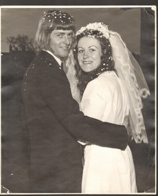
Photograph - JOAN FILBY COLLECTION: WEDDING PHOTOGRAPHS, 1972
a. Photograph. A black and white photograph of bridal couple Joan Maree Roberts and Jeffrey Raymond Filbey. Printed by the Bendigo Advertiser Newspaper. Wedding and photograph date 29/07/1972. An original photograph. Mother of the bride made the wedding dress. b. Photocopy of newspaper article from Bendigo Advertiser. c. Wedding Photograph. Adeline Isabell Vogele. Adeline was born in 1928 and lived in Eaglehawk. She married Hugh Simpson Vogel in 1953. Hugh was a farmer from Sebastian. Hugh died in 1981 and is buried at Eaglehawk Cemetery. Adeline died in 2006. Colour tinted photo by Richard Kelly, mounted on board. d. and e. Wedding egg. Small plastic egg with engraving of Cupid. Inside is a black glass bottle of perfume with stick on labels 'Mischief' and 'Saville'photograph, portrait, wedding -
 Bendigo Historical Society Inc.
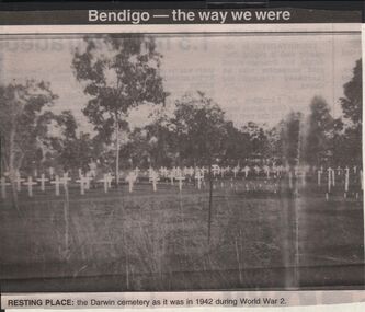
Newspaper - JENNY FOLEY COLLECTION: RESTING PLACE
BHS CollectionBendigo Advertiser '' The way we were'' from 2003. Resting place: the Darwin cemetery as it was in 1942 during World War 2. The clip is in a folder.newspaper, bendigo advertiser, the way we were -
 Bendigo Historical Society Inc.
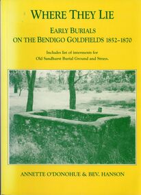
Book - STRAUCH COLLECTION: WHERE THEY LIE
... Bendigo-history-burials-cemetery...BHS Collection BENDIGO Cemetery early burials Bendigo ...BHS CollectionWhere They Lie early burials on the Bendigo goldfields 1852-1870 includes list of interments for Old Sandhurst Burial ground and strays. 152 pages with black & white photographs.Annette o'Donohue & Bev Hansonbendigo, cemetery, early burials, bendigo-history-burials-cemetery -
 Bendigo Historical Society Inc.
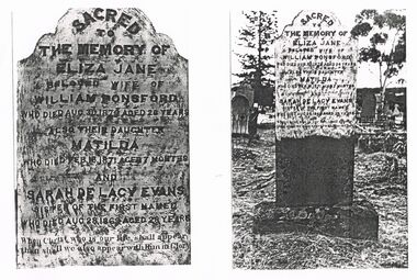
Document - COPIES OF PHOTOGRAPHS OF TOMBSTONE: ELIZA JANE (AND SARAH DE LACY EVANS)
Edward (Edmund) de Lacy Evans was really Ellen Tremaye; and in 1856 she married her fellow passenger on her voyage to Australia, Mary Delahunty; under the assumed name of EDMUND De Lacy. In 1859 he/she married Sarah Moore. They were married for eight years when in 1867 she died in childbirth. In 1868 after Sarah had died; Ellen, now known as EDWARD de Lacy Evans married Julia Mary Marquand in Ballarat. From the Melbourne Argus Friday 5th Sept 1879, Page 7 THE EXTRAORDINARY PERSONATION CASE. [BY ELECTRIC TELEGRAPH. FROM OUR OWN CORRESPONDENT.) SANDHURST, THURSDAY. The De Lacy Evans case has created great excitement here. The man-woman having resided in the district for about 20 years, was well known amongst the miners, but no one appeared ever to have supposed that she was other than as she represented herself to be, and the discovery of her sex has caused the greatest astonishment. The police have not yet moved in the matter of the discovery of her antecedents, but from the result of inquiries I have made, there seems to be no room to doubt that the woman is identical with the girl Ellen Tremaye, referred to in yesterday's telegram as having arrived at Melbourne by the ship Ocean Monarch in June, 1857. The nurse at the hospital, Mrs. Holt, is positive she is the same, and says the opinion was held amongst those on board the vessel that Tremaye had been well connected, and that she had left home in consequence of some misconduct. The Ocean Monarch was an immigrant vessel, and on the voyage Tremaye and another young woman, named Rose Kelly, were very intimate, but the latter, being seized with a dangerous illness, was left at Rio Janiero. Mrs. Evans, the wife of the supposed man, states that she frequently heard Evans say that she came out by the Ocean Monarch. But the most satisfactory information of Evans' previous history yet received has been obtained from a Mrs. Thompson, a charwoman at Myers' Creek, who was also a shipmate of the girl Tremaye. At the time she made the voyage she was unmarried, and was accompanied by Miss Mary Ann Delahunty, a young lady who was very well connected, and who came from the same village as herself, named Monakine, on the north bank of the river Suir, in Kilkenny. Miss Delahunty was an orphan and brought with her about £900. After Rose Kelly was taken ill, Tremaye resorted to Miss Delahunty's berth, and the passengers appeared to think there was something strange about the manner in which Tremaye conducted herself, and she had been observed to wear a man's under-clothing. Upon the arrival of the ship in Hobson's Bay, Tremaye declared herself to be a man, and told Mrs. Thompson she intended to marry Miss Delahunty. The next Mrs. Thompson saw of Ellen Tremaye was at Peg-leg Gully, Eaglehawk. Tremaye had just established herself in a house there under the name of Edward de Lacy Evans, and Mrs. Thompson went to serve them with milk. When she went to the house, she saw Evans sitting inside dressed in male attire, and immediately recognised him as her fellow passenger, Ellen Tremaye. Evans had, at this time, married his second wife, Miss Moore, who was then present. Evans re-marked to her—"I think I know you." To which Mrs. Thompson replied—"I know you, too," and added something to the effect that Ellen (referring to Tremaye) was a queer girl." Oh, said Evans, evidently anxious that his then wife should not understand Mrs. Thompson's reference, "It's a good job she is gone back to the old country." Mrs. Thompson inquired as to what had become of Miss Delahunty, and Evans replied, "Oh, my poor wife and boy both died of consumption, and are buried in the North Melbourne cemetery. " In reply to an inquiry as to what had been done with her (Delahunty's) money, Evans said she had sent it home to a nunnery. Evans's then wife had been absent during a portion of this conversation, but at this point she returned, and Evans went outside to the milkwoman, and said, "For your life don't mention my dead wife's name ; call me Mr. Evans. This missus of mine is death on the Roman Catholics, and she can't bear to hear my dead wife's name mentioned." This conversation took place about 12 or 14 years ago, and Mrs. Thompson seems to have quite believed that Evans had personated a woman under the name of Ellen Tremaye on the voyage out and was really a man. She lost sight of Evans soon afterwards, and took no further notice of the affair.Copies of Photographs of Tombstone - Eliza Jane Ponsford and daughter Matilda and Sarah De Lacy Evans (''who was the sister of Eliza Jane Ponsford''). One photo showing detail of text; the other showing background of cemetery. (De Lacey)eliza jane ponsford, ellen tremaye, sarah moore, julia mary marquand, mary delahunty, de lacy evans, de lacy, edward de lacy evans, edmund de lacy, bendigo -
 Bendigo Historical Society Inc.
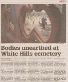
Newspaper - Article on bodies unearhted, Jan 25, 2020
... the White Hills cemetery. Some 10% of the Chinese bodies were ...In 1867 a body belonging to a Chinaman was taken from the White Hills cemetery. Some 10% of the Chinese bodies were removed and many sent home to China.Bones were cleaned and any remaining flesh was preserved in gin.Bendigo Advertiser: Story on bodies unearthed at the White Hills cemetery.white hills cemetery, chinese bodies -
 Bendigo Historical Society Inc.
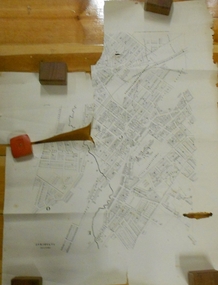
Document - MARKS COLLECTION: PLAN OF SANDHURST CITY CENTRE AND SURROUNDING AREA ( NO. 1 )
Plan on heavy parchment - section neatly cut out of area now Kennington. Written on plan in black print ' Sheet No. 1. Sandhurst'. Plan shows Government Camp, Commissioner's Gully, old cemetery site, manure depot, cattle market, Benevolent Asylum Reserve, railway reserve. Landowners' names on allotments. On bottom lithographed at the Department of Lands and Survey, Melbourne, by D. Henerson, March 12th., 1867 Plan part of George Lansell, Fortuna auction, documents found in wardrobe purchased by Marks family in 1930's.bendigo, planning, sandhurst 1867 -
 Federation University Historical Collection
Map, Ballaarat Gold Field, 1861, 21/10/1861
A party of surveyors camped by Yuille's Swamp (later Lake Wendouree) and surveyed the countryside for a map to be produced by the Geological Survey of Victoria. In November 2004 the Central Highlands Regional Library presented a special edition of 200 copies of the 1861 map reproduced from a copy in their collection. Original geological map of Ballarat showing property, waterways, mines, churches, schools, water races, and garden reserves. It was compiled and drawn from the surveys of Mining Surveyors Davidson, Fitzpatrick and Cowan.Compiled & Drawn from the Survey of Mining Surveyors Davidson, Fitzpatrick and Cowan & the Plans in the Surveyor General's Office by J. Brahe, 21st October 1861. R. Brough Smyth, Secretary for Mines. The Honourable J.B. Humffray, M.L.A. Commr of Mines.ballarat, map, davidson, robert brough-smyth, fitzpatrick, cowan, yuille's swamp, public garden reserve, manure depot, black hill, ballarat east, old post office hill, pennyweight hill, claytons hill, golden point, mining, railway, cricket ground, swamp creek, cemetery, sludge reserve, bakery hill, gaelic church, juvenile reformatory, orphanage, specimen hill, eureka lead, cattle yard hill, dalton's flat, chinese village, poverty hill, railway reserve, little bendigo diggings, pound reserve, allied armies, flour mill, agricultural reserve, marsh, survey reserve, survey corps, white flat, yarrowee, yarrowee creek, brache, j. brache, survey, ballaarat gold field 1861 -
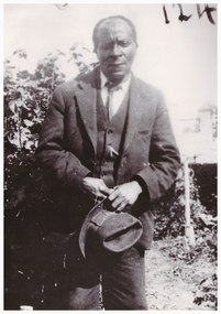
 Linton and District Historical Society Inc
Photograph, Tom Andrews, 1936
Tom Andrews, whose father (also called Tom) was thought to have come to Linton from Jamaica, lived near the Battery Dam. Little is known of his life, other than that he attended the Methodist Church and was "a very respected citizen". He is in a photograph of the Linton football team taken c.1915-1920. (Registration number 2019-247 - Mounted photograph 424.) Tom was a member of the Old Lintonians' Association and attended its reunions in the 1930s. He died at Bendigo in 1937, and is buried with other members of his family in Section 2 of the Linton cemetery. Photograph is part of Old Lintonian collection ; No. 124.Black and white photograph of a man, of African-American appearance, dressed in two piece suit, collar and tie, holding hat with both hands in front, and standing in a garden."Tom Andrews Easter 1936 taken by J W Hall".tom andrews, old lintonian collection -
 Bendigo Historical Society Inc.
Document - LONG GULLY HISTORY GROUP COLLECTION: HISTORICAL GUIDE TO BENDIGO
... Bendigo Cemetery... of the Mines Telegraph Office Bendigo Cemetery White Hills Cemetery ...Brochure with an invitation to visit Historical and Mining Museum in Mechanic's Institute, Eaglehawk. Drawing of poppet legs on the front with The Royal Historical Society of Victoria Bendigo Branch. Historical Guide to Bendigo including Self Tours of Bendigo's Famous Goldfields. Forward by John Hattam. Contributors are: H Biggs, Miss L J Parry, A Richardson, L C Bennetts and Edith Checcucci. Credits - The Bendigo Advertiser, Cambridge Press, Mines Department (Bendigo) and J R W Purves. Items include Bendigo Tramways Compiled by H Biggs, Early Bendigo Hotels Compiled by L C Bennetts, Eaglehawk Compiled by H Biggs, Noted Events Compiled by June Parry, The Bendigo Post Office Compiled by LC Bennetts, The Bendigo Goldfield. Introduction to Field and Guide to Some Famous Mines Compiled by A Richardson. Photos include: Pall Mall Bendigo, Ravenswood Homestead, An Early Battery at Kangaroo Flat, Historic High Street Golden Square, The Lonely Grave, Battery Tram c1888, Steam Tram c1892, Electric Tram c1903, The New Chum Railway Golden Square, United Hustlers and Redan Mine Sandhurst Road, Central Deborah Violet Street, Deborah Mine Quarry Hill, Deborah Mine 1000 ft level, First Motion Winding Engine at Central Deborah, Victoria Hill Area, and Looking south from New Chum Hill in 1890's. Also 11010.254, 255, 268, 288a, 288b, and 289.bendigo, history, long gully history group, the long gully history group - historical guide to bendigo, the royal historical society of victoria bendigo branch, historical and mining museum, mechanic's institute eaglehawk, librarian mechanic's institute, miss j parry, john hattam, h biggs, a richardson, l c bennetts, edith checcucci, bendigo advertiser, cambridge press, mines department (bendigo), j r w purves, mr a o'keefe, shire of marong, the sandhurst and eaglehawk tramway company, mr j taylor, mr j hanson, the bendigo tramway company, electric supply company, coliban water suply, juvenile industrial exhibition, geo lansell, cr a harkness, salvation army, vine and fruitgrowers association, decentralisation league, constable thomas ryan, miners association, art gallery, post office, miss broadfoot, bendigo hospital, opera company, bendigo development league, victorian women's franchise league, ana hall, the bendigonian, law courts, temperance hall, trades hall (old wardens court), roman catholic cathedral, shamrock hotel, bendigo philosophical society, old bendigonian society, bendigo fire brigade, bendigo volunteers to south african war, hawkins, porcupine inn, criterion hotel, royal hotel, bendigo hotel, black swan hotel, gillies bakery, hibernian hotel, sandhurst hotel, freemasons hotel, courthouse hotel, shamrock hotel, governor hotham, heffernan & crowley, new chum railway, victoria quartz, shenandoah, shamrock mine, hercules no 1 (originally pearl east), hercules new chum (late pearl), carlisle mine, mr arblaster, meurer, sandhurst bee, benevolent asylum, bendigo gas company, a lloyd, coliban water supply scheme, cr w v simons, eaglehawk council, j mouat, sir henry barkly, agricultural and horticultural exhibition, sandhurst and eaglehawk boroughs, cr john mcintyre, latham and watson's mine, galatea (model ship), st paul's church of england, rev g p despard, fine arts exhibition and exposition, bendigo rifle association, strathfieldsaye shire hall, corporate high school, bendigonian society, richard andrews, easter fair, g aspinall, j burnsides, sir h manners sutton, beehive stores, mining exchanges, bendigo water works, city family hotel, bendigo united friendly society medical institute and dispensary, benevolent asylum, jewish synagogue, masonic hall, school of mines, mr j h abbott, australian natives association, royal princess theatre, albion hall, central state school, high school, gravel hill state school, electricity commission, james mouat, warring natives, the rocks, joseph crook, gold discovery, marong district roads board, camp hotel, mr charles sherratt, city of bendigo, mt alexander north run, grice and heape, ravenswood, gibson and fenton, mrs john kennedy, mrs patrick farrel, mr j a paton, mr lachlan mclachlan, theatre royal, sir charles and lady hotham, harney's bridge, e j ennor, sandhurst fire brigade, the health of towns act, mr townsend, cornish & co, bendigo pottery, bendigo agricultural society, pike or pyke, baby health centre, sandhurst post office, government survey office, sandhurst trustees company, mr h b briston, savings bank, telegraph office, sir henry brougham lock, hon sir john nimmo, sandhurst public offices, the new prince of wales mine, new prince of wales no 2, the whip and jersey, lansell's big 180, new chum and victoria mine and battery, new chum railway, koch's pioneer, south new moon, catherine reef united, new moon, virginia mine, south belle vue, new chum railway, central nell gwynne, north nell gwynne, ironbark mine, new chum syncline, hercules, herculesl energetic, roberts & sons, harkness & co, horwoods, great southern, ulster, carlisle, cornish, new st mungo, duchess tribute, south devonshire, hopewell mine, saxby mine, mcnair & co, mr king, bourke and wills, sandhurst hotel, the dascombe nugget, victoria nugget, r r haverfield, ballerstedt, rae, wittscheibe, lazarus, cave and amos, bendigo amalgamated goldfields, bendigo mines limited, the deborah, north deborah, central deborah, the new red white and blue consolidated (big blue), union, lansell's new red white and blue 9later no 3 shaft), h harkness & co, thompson & co, central deborah, lansell's bendigo battery, north red white and blue, central red white and blue, roberts and sons, little 180 (originally lansell's 180 no 2 shaft), john brown knitwear factory, south ironbark originally victoria consols east shaft, ironbark (originally ironbark east shaft), manchester arms hotel, wattle gully mine chewton, hercules, old wheal-owl, central nell gwynne, gold mines hotel, bendigo city council, jack barker, the new chum syncline, the courier of the mines, telegraph office, bendigo cemetery, white hills cemetery, eaglehawk cemetery, kangaroo flat cemetery, new moon, suffolk united, north new moon, fortuna hustlers, buckell & jeffrey's, royal hustlers reserve no 2 (city and park shafts), jonathan harris, latham and watson, great hustlers, great extended hustlers, j hustler, latham, watson, tribute or pups shaft, bendigo's worst mining disaster, hustlers reef (old hustlers), hustlers reef no 1, lansell's comet, the old comet (cooper's claim), united hustlers and redan, comet hill state school, k k shaft, north or new hustlers (agnew hustler), johnson's no 3, south johnson's, lansell's sandhurst needle, cleopatra needle top, british american, collman and tacchi, south virginia, saddle reefs and spurs, pall mall bendigo, ravenswood homestead, an early battery at kangaroo flat, historic high street golden square, the lonely grave, battery tram c1888, steam tram c1892, electric tram c1903, teh new chum railway golden square, united hustlers and redan mine sandhurst road, central deborah violet street, deborah mine quarry hill, deborah mine 1000 ft level, first motion winding engine at central deborah, victoria hill area, looking south from new chum hill in 1890's -
 Bendigo Historical Society Inc.
Document - John Beebe's Observatory Bendigo, Peter Anderson's article 2020
John Beebe was born in Sandhurst (Bendigo) in 1866. In his earlier years, John and his brother William operated a stonemason's business in Bendigo, designing and making monuments. John graduated as an architect in 1900 . By 1910, John was in sole practice in Bendigo, when he was appointed as architect for the Anglican Diocese. His churches from this period St. Paul's bluestone church in Axedale and St. John's in North Bendigo. He moved to Brisbane in 1916, possibly for health reasons. He died on 15 December 1936 and is buried in the Lutwyche cemetery in Brisbane in an unmarked grave. Lutwyche Cemetery Kedron, Brisbane City, Queensland, Australia Plot MONUMENTAL-COE3-25A-21 https://www.findagrave.com/memorial/239489809/john-beebe Four page collection of research on the observatory built by John Beebe at his residence at 55 Condon Street, Kennington. Articles are: one page brief biography "John Beebe's Observatory in Condon Street'; includes mention of how he acquired the telescope that was built into the brick observatory at Condon Street. "the building is a very rare survivor and an important relic of late 19 century scientific endeavour in Bendigo and should be placed on the Victorian Heritage Register'. Second article: two pages 'John Beebe, Architect, owner of East Bendigo Observatory. His later life in Queensland 1916 - 1936, by Peter Anderson April 2020. Article includes family history; John Beebe earlier life' John's brother William and his son Wilfred John Beebe; John's career in Bendigo; Astronomy in Bendigo; Fellowship of the Royal Astronomical Society and the move to Brisbane, Queensland and speculation upon the reasons. Third article: 'Our heritage in danger - amazing observatory comes to light' by Mike Butcher. Article addresses the significance of Beebe's observatory building ' and is representative of the city's early endeavours into scientific research'. At end of article a colour photo of the observatory with the heading 'John Beebe's observatory in Condon Street under threat of demolition'. john beebe, william beebe, observatory, 55 condon street kennington, stonemason, architect, st. pauls axedale, st. john's north bendigo, heritage significance -
 Bendigo Historical Society Inc.
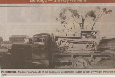
Newspaper - JENNY FOLEY COLLECTION: IN CONTROL
... at Eaglehawk Cemetery NEWSPAPER Bendigo advertiser the way we were ...Marian Packham was born in 1928. In 1954 she married Ronald George Riley and she die in 2017. Marian and Ronald are buried at Eaglehawk CemeteryBendigo Advertiser ''The way we were'' from 2002. In control: Marian Packham sits at the controls of a caterpillar tractor bought by William Packham in 1948. The clip is in a folder.newspaper, bendigo advertiser, the way we were -
 Bendigo Military Museum
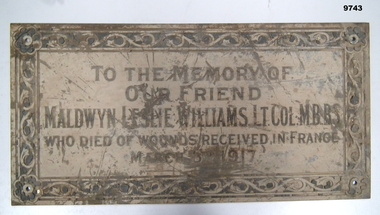
Plaque - MEMORIAL PLAQUE, WW1, C G Roeszler & Son, Post WW1
Born in Castlemaine 1886. Maldwyn L. Williams (Leslie) was a prominent doctor in Bendigo, both at Bendigo Base Hospital and in private practice. He played several games in the Victorian Football League (VFL) whilst at university. Enlisted in Citizens Military Force in 1909 as Captain in Royal Australian Army Medical Corps. Promoted to Major in 1913. Sept 1915 - appointed Major in regular army, 8th Field Ambulance Unit. Nov 1915 - sailed for Egypt; June 1916 - sailed for Marseilles. Jan 1917 - promoted to Lt. Colonel and command of 1st Field Ambulance Unit. Wounded near Bapaume 2nd March 1917; died from wounds 3rd March 1917. Buried at Dernancourt Cemetery, France. The engraver of the plaque was C.G. Roeszler & Son of Melbourne. This business was founded in 1869 and is still family-owned and trading today. This company is responsible for many examples of engraving around Melbourne, including work on the 1928 Ringwood Memorial Clock and in St Paul's Cathedral in Flinders St, Melbourne. Rectangular metal plaque, possibly brass. 4cm border featuring botanical motif. A flower with eight round petals at each corner - each flower has a 0.7cm hole at its centre. Decoration and inscription engraved and filled with black material, possibly shellac or enamel paint which is degraded, cracking, and loose.Main inscription: "TO THE MEMORY OF/OUR FRIEND/MALDWYN LESLIE WILLIAMS. LT. COL, M.B,B.S./WHO DIED OF WOUNDS RECEIVED IN FRANCE/MARCH 3RD ['RD" is in smaller font and higher that other letters with a dot beneath] 1917.' Bottom right: "C.G. ROESZLER & SON MELB".plaque, memorial -
City of Moorabbin Historical Society (Operating the Box Cottage Museum)
Newsletter - CMHS Moorabbin Mirror Vol 3 August 2015, Moorabbin Mirror Vol 3 August 2015, August 2015
... , brighton cemetery, bendigo bank ormond, stanley's menwear bentleigh... Display at Bendigo Bank Ormond and the Sandbelt Milestones ...This is Vol. 3 of the Moorabbin Mirror produced by CMHS members Fran & Holger Bader , Valma Sharp August 2015 The Moorabbin Mirror reflects the history and heritage of the former City of Moorabbin — derived from Mooroobin, ‘a resting place’ in the Bunurrung spoken language. In 1994, the City of Moorabbin was integrated into the Cities of Bayside, Glen Eira, Kingston and Monash. Members are informed of the Heritage Display at Stanley's Menswear, Bentleigh East, in conjunction with Glen Eira HS, Market Garden Display at Bendigo Bank Ormond and the Sandbelt Milestones at Brighton Cemetery, Godfrey Street Community House, St Peter's Church & School, the ongoing Gallipoli Centenary and Moorabbin Saints AFL team at Linton Street. Dates for Committee Meeting, General Meeting and the upcoming AGM in October. Photos from The Booklet and Leaflet Launch on May 13th, a request for information about the Womens’ Farm Mordialloc c 1916 , advertisements for the Bayside Arts & Cultural Exhibition featuring Tommy Bent and the RHSV Exhibition re MacPherson Robertson featuring the bust made by August Reitman at Box Cottage . Open Days are listed with an invitation for new members showing the benefits and duties of CMHS membership. CMHS thanks The Office of the Hon. Andrew Robb AO MP Minister for Trade & Investment, Federal Member for Goldstein, who photocopied this newsletter under community printing entitlements. This is Vol. 3 of the Moorabbin Mirror, Newsletter of CMHS August 2015 A4 x 3 paper folded to A5 x 6pp with colour photographs. Moorabbin / Mirror / August 2015 Issue 3 moorabbin mirror, bader fran, bader holger, sharp valma, bent tommy, mordialloc womens farm c1916, gallipoli landings 1915, robertson macpherson, reitman august, godrfrey street community hhouse bentleigh, st peter's church bentleigh east, brighton cemetery, bendigo bank ormond, stanley's menwear bentleigh, glen eira historical society, launch of box cottage museum publications 2015, glen eira city council,east -
City of Moorabbin Historical Society (Operating the Box Cottage Museum)
Newsletter - City of Moorabbin Historical Society Nov. 2015, November 2015
... , brighton cemetery, bendigo bank ormond, stanley's menwear bentleigh... cemetery, bendigo bank ormond, stanley's menwear bentleigh, glen ...This is Vol. 4 of the Moorabbin Mirror produced by CMHS members Fran & Holger Bader , Valma Sharp November 2015 The Moorabbin Mirror reflects the history and heritage of the former City of Moorabbin - derived from Mooroobin, ' a resting place' in the Bunurrung spoken language. In 1994 the City of Moorabbin was integrated into the Cities of Bayside, Glen Eira, Kingston and Monash. Members are asked to assist GECC Arts & Culture Dept. with information about the Caulfield Repatriation Hospital. Fran compiled a brief history of the 'Garden Suburb of Ormond, Henry Lawson and ANA Society with a contribution from Rosemary Kelleher describing her father Brian's love of poetry. All members are invited to attend the final Open day on November 29th to join with the Henry Lawson Society and ANA for their Annual Brian Kelleher Memorial Picnic . Photographs of the CMHS at Bunnings, Stanley's Menswear and the 'Unmentionables' display at Box Cottage are included in this issue. The CMHS thanks the retiring President Frank Thatcher and Treasurer Bill Richardson for their work for the Society and welcomes the incoming Committee lead by Mrs Valma Sharp President. Mrs Lorna Thatcher was recognised for her long service to CMHS with Life Membership accepted by members. Open Days are listed with an invitation for new members showing the benefits and duties of CMHS membership. CMHS thanks The Office of the Hon. Andrew Robb AO MP Minister for Trade & Investment, Federal Member for Goldstein, who photocopied this newsletter under community printing entitlements.A4 x 3 paper folded to A5 x 4 pages with colour photographsMoorabbin / Mirror / November 2015 Issue 4moorabbin mirror, bader fran, bader holger, sharp valma,gallipoli landings 1915, robertson macpherson, reitman august, brighton cemetery, bendigo bank ormond, stanley's menwear bentleigh, glen eira historical society, glen eira city council,, thatcher lorna, thatcher frank, richardson bill, henry lawson society, ana society, kelleher brian, sharp valma, monash, kingston, bayside, -
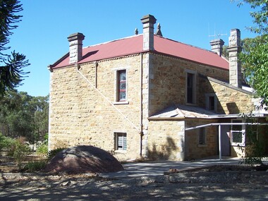
 Bendigo Historical Society Inc.
Photograph - Rocky Vale Villa, April 2016
The Beebe name was well-known in Bendigo in the last quarter of the 19th and the early part of the 20th centuries. From 1875, William Beebe senior, monumental mason, occupied a site in the centre on the city, in Mitchell Street opposite King Street. Death was more part of life in those days, and the Beebes were there to provide the burial monuments. Later, he took his sons into the business, which grew as Beebe and Son. Many examples of their work can be found in the local cemeteries. William Beebe senior (1830-1891) was born in Rutland, the smallest English county in 1830, to stonemason Chamberlain Beebe and Susannah Clements. William emigrated to Victoria in 1854 and after engaging on unknown works in Port Fairy, Dunkeld, and Melbourne arrived in Bendigo. His obituary records that he commenced work here on the site of the Bank of Australasia (opposite the Shamrock Hotel), which would have been no later than 1856. He took up a 13 acre selection on the site of Rocky Vale Villa in 1864 and continued to select or purchase further parcels of adjoining land until he owned some 150 acres, much of it unfit for cultivation. He was a keen gardener and had a garden and orchard around the house. William took over 20 years to build the two-story sandstone and granite house "Rocky Vale Villa". The house was constructed from sandstone sourced "from an adjacent ridge of rocks" (Bendigo Advertiser 28/9/1891). Granite from Harcourt was used for lintels and quoins. Not long before he died, William was still adding to the house. In the Codicil to his will, he states that "I have just built and completed two additional rooms to my Dwelling house situe at Inglewood Road aforesaid" (dated 19/9/1891). William died one week later on the 26th September 1891.Photographs of a field trip to Rocky Vale Villa, 7 Wicks Road, Maiden Gully, Bendigo by the Bendigo Historical Society.history, bendigo, rocky vale villa maiden gully, william beebe stonemason bendigo -
 Bendigo Historical Society Inc.
Document - NATIONAL TRUST COLLECTION: CEMETERIES, 1987-1988
... BENDIGO Cemetery white hills cemetery Cemeteries Series ...Cemeteries Series of letters re Chinese section of White Hills Data form for White Hills Letters re maintenance of White Hills Acknowledgement of nomination of Chinese Funeral Towerbendigo, cemetery, white hills cemetery -
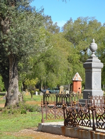
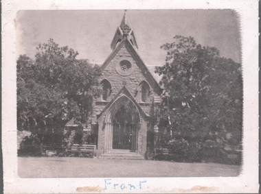 Bendigo Historical Society Inc.
Document - NATIONAL TRUST COLLECTION: CEMETERY CHAPEL, 1982
... bendigo cemetery chapel...BENDIGO Cemetery bendigo cemetery chapel Cemetery Chapel ...Cemetery Chapel Classification by the National Trust Article from the Bendigo Advertiser 26/8/1980 Description of the chapel - handwritten and typed. Black and white photos.bendigo, cemetery, bendigo cemetery chapel -
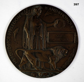 Bendigo Military Museum
Memorabilia - MEMORIAL PLAQUE, Post WW1
Samuel Marshall No 11/1925, 2nd Battalion Otago Regt New Zealand Expeditionary Force, KIA 15.9.1916. Buried Bulls Road Cemetery Flyers.111.F.20. Son of Mr & Mrs A.G.Marshall of 168 Bridge Street Bendigo Vic.Commemorative Bronze plaque for Samuel Marshall (Killed In Action) WW1 Centre of Plaque is Brittania with Lion & Seals Rectangular section for Individuals Name.He died for Freedom and Honour " Samuel Marshall"commemorative military, plaques -
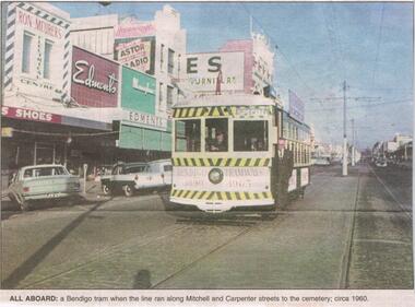 Bendigo Historical Society Inc.
Newspaper - JENNY FOLEY COLLECTION: ALL ABOARD
BHS CollectionBendigo Advertiser ''The way we were'' from 2002. All aboard: a Bendigo tram when the line ran along Mitchell and Carpenter streets to the cemetery, circa 1960. The clip is in a folder.newspaper, bendigo advertiser, the way we were