Showing 64634 items matching "church-of-england"
-
 Ballarat Heritage Services
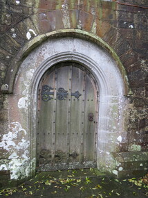
Photograph - Colour, Door, Alwington Church, Devon, England
-
 Ballarat Heritage Services
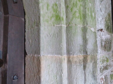
Photograph - Colour, Stonemason Mark on Door, Church, Alwington, Devon, England
-
 Ballarat Heritage Services
Photograph - Colour, Doorway with stonemason marks above, Alwington Church, Devon, England
-
 Ballarat Heritage Services
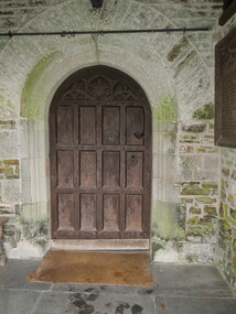
Photograph - Colour, Door on Church, Alwington, Devon, England
-
 Ballarat Heritage Services
Photograph - Colour, Plaque, Church, Alwington, Devon, England
-
 Ballarat Heritage Services
Photograph - Colour, Roof on porch, Church, Alwington, Devon, England
-
 Ballarat Heritage Services
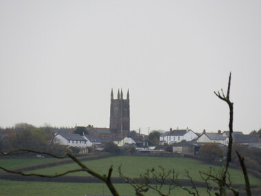
Photograph - Colour, Alwington Church, Devon, England
-
 City of Kingston
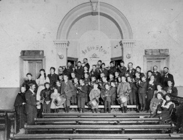
Photograph - Digital image, Black and white, Fife and Drum boys at Church of Christ, Chesterville Road, Cheltenham, c. 1900
... Fife and Drum boys at Church of Christ, Chesterville Road ...Fife and Drum boys at Church of Christ, Chesterville Road, CheltenhamBlack and white image of boys standing on a a church alter and front row pews holding fife and drumsRound red sticker: X6 [crossed out] Handwritten in black ink: CHAP 4? / Boys Band Handwritten in blue ink and circled: A14/ Handwritten in red ink: 72% fife, drum, boys, church, church of christ, chesterville, cheltenham -
 Port Melbourne Historical & Preservation Society
Programme, Programme of the Tour and Matches arranged for the First Visit of the Australian Women's Cricket Team 1937 to England, 1937
... Programme of the Tour and Matches arranged for the First ...Material on cricketer Peggy ANTONIO: Photocopies of Programme of the Tour and Matches arranged for the First Visit of the Australian Women's Cricket Team to England in 1937. plus photocopies of test results and map of Australian Women's test cricket tour 1937sport - cricket, peggy howard nee antonio -
 Glen Eira Historical Society
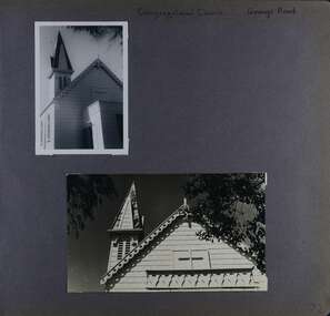
Album - Album page, Congregational Church, Grange Road, Circa 1972
This photograph is part of the Caulfield Historical Album 1972. This album was created in approximately 1972 as part of a project by the Caulfield Historical Society to assist in identifying buildings worthy of preservation. The album is related to a Survey the Caulfield Historical Society developed in collaboration with the National Trust of Australia (Victoria) and Caulfield City Council to identify historic buildings within the City of Caulfield that warranted the protection of a National Trust Classification. Principal photographer thought to be Trevor Hart, member of Caulfield Historical Society. Most photographs were taken between 1966-1972 with a small number of photographs being older and from unknown sources. All photographs are black and white except where stated, with 386 photographs over 198 pages. This church has since become the Greek Orthodox Church. From Victorian Heritage Database: Citation for Greek Orthodox Church HO84 https://vhd.heritagecouncil.vic.gov.au/places/43587 (as at 19/10/2020) The former Primitive Methodist, later Congregational, church at 152 Grange Road, Glenhuntly, is a small timber building, erected in 1885 (89?) in South Melbourne and relocated to Glenhuntly in 1909. It is a highly individual picturesque timber structure with distinctive spire and timber enrichment. It has aesthetic, historical and social significance. Its aesthetic value is derived from the choice of materials and picturesque Gothic Revival character showing American influence. Its historical value is derived from its survival as a rare example of a Primitive Methodist Church building whilst its social value hinges on its early roles as a place of worship for the Primitive Methodists in South Melbourne and the Congregationalists in Glenhuntly.Page 72 of Photograph Album with two photographs (one portrait and one landscape) of the upper exterior and tower of the Congregational Church on Grange RoadHand written: Congregational Church, Grange Road [top right] / 72 [bottom right] trevor hart, congregational church, grange road, gothic revival, carnegie, glen huntly, glenhuntly, greek orthodox church, primitive methodist church, spire, timber buildings -
 Surrey Hills Historical Society Collection
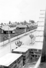
Photograph, Union Road looking west from the steeple of Holy Trinity Church, 1922, 1922
... Union Road looking west from the steeple of Holy Trinity ...At the edge of the church roof and on the horizon is 'The Knoll' on the corner of Union Road and Wandsworth Road. To the left of this is 297 Mont Albert Road, home of the Michael Parer family and further left is "Quamby", home of the Sherar family. This is easily recognised by the square viewing tower located on the west wing of the house. The Sherar family owned 'Quamby' from 1900 until 1925, when it became Mosgiel Private Hospital. Norman Carter took many photos of Surrey Hills and Mont Albert in the 1920s; many associated with events and activities of the Church of England. Black and white photo of taken from the steeple of Holy Trinity Church, during its construction, across Union Road to the north-west. In the foreground immature street trees can be seen and an original telephone pole with white insulators. The street has formed paths and bluestone kerb and channelling. holy trinity anglican church, union road, the knoll, quamby, street trees, telegraph and light poles, mosgiel hospital -
 Port Fairy Historical Society Museum and Archives
Photograph
St Johns Church of England with the towerBlack and white photograph of St Johns Church of England with towerchurch, sunday-school, building, church of england, anglican, tower -
 Bendigo Military Museum
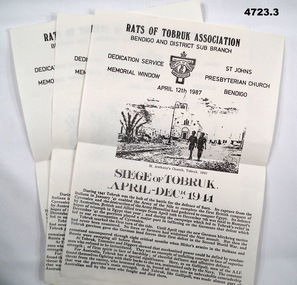
Pamphlet - PAMPHLETS, RATS of TOBRUK ASSOC, Rats of Tobruk Association, Dedication Service, Memorial Window, St. John's Presbyterian Church, Bendigo. 12 April 1987
... Rats of Tobruk Association ...The Bendigo Rats of Tobruk Association donated a memorial window to the St John's Presbyterian Church, Bendigo. 12 April 1987.1. Single A4 size sheet, printed on one side only. At top there is the Rats of Tobruk Association crest. Title as above. A grainy picture of two soldiers walking in a town with a palm tree. Caption states St. Anthony's Church Tobruk 1941. Bottom half is a summary title "Siege of Tobruk April-Dec 1941" 2. Single A4 size sheet, printed on one side only. At top there is the Rats of Tobruk Association crest. Title as above. A grainy picture of two soldiers walking in a town with a palm tree. Caption states St. Anthony's Church Tobruk 1941. Bottom half is a summary title "Siege of Tobruk April-Dec 1941" 3. Single A4 size sheet, printed on one side only. At top there is the Rats of Tobruk Association crest. Title as above. A grainy picture of two soldiers walking in a town with a palm tree. Caption states St. Anthony's Church Tobruk 1941. Bottom half is a summary title "Siege of Tobruk April-Dec 1941"Nilww2, tobruk, bendigo -
 Ringwood and District Historical Society
Photograph, Early Catholic Church Building, Bedford Road, Ringwood - circa 1960s and 1976, 1976
Old Catholic Church building in mid 1976Written on back of photographs, "Old Catholic Church - mid 1976". Written on back of enlargement, "Old Catholic Church, Ringwood - built 1893". -
Ringwood and District Historical Society
Memorabilia - Envelope, Packet: Ringwood Methodist Church - Anniversary Pamphlets, Cuttings, Pictures, Hand written notes
Churches - Ringwood Methodist Church3785.1 A hand written notes of the early history of the church. Several to the Town Clerk from the Ringwood Church trust and thr Public health department. 2. Minutes of meeting of the Ringwood Parsonage Trust 1909 and 1910 3. The Record of the Box Hill and Ringwood Methodist Circuits. Hand writen list of members of Ringwood Circuit. 4. Flyer for Back to Ringwood Methodist Church Jubilee, March 9th to 17th. 1929. Letter to Richard Carter from Aub (sic) who was eight years old at the time and can remember the Jubilee 4 Booklets about the Church Also a name tag for Miss V. Watson Assist. Secretary. Several cuttings, one full page spread from the newspaper about the Jubilee. 5. Ringwood Methodist Sunday School Tea and Meeting. Cutting from the Ringwood & Croydon Mail. The Wigley family were greatly represented. 6. Diamond Jubilee 17-28th. March ,1939 Program of Events 7. Six pages of hand written letters from the Methodist Circuit, letter to the Ringwood Councillors inviting them to the Centennary Celebrations of the Church,letter to the Town Clerk from Methodist Sunday School Surrey Hills regarding a picnic in Ringwood. 8. Ringwood United Churchmen's Association syllabus 1937 9. Pamphlet about Sunday Sport and the Christian Duty to Vote. 10.Ringwood Methodist Church news July 1963 11. Two Ringwood Methodist Church pamphlets for the 75th. Anniversary March 17th.-28th. 1954. 12.Copy of lease from the Methodist Church Trust for 30 years to use land in Ringwood 13. Carols by Candlelight (no year) and the Ringwood Methodist Church News March 1958, With memories of Christmas. 14.Pamphlet of the Laying of the Foundation Stone Saturday 18th. May 1963 and two pamphlets of the Opening and Dedication of the Ringwood Methodist church 9th. november 1963. 15.'The Messenger' Journal of the Ringwood Methodist Church December 1963. 16'. Forward in Faith' Review Stewardship Canvass August 1961. 11 pages outlining the plans for the proposed new Church. 17. Foolscap sheet typed with the Evening Service Sunday 6th. December 1970 with the Combined Circuit Choirs .Excerpts from 'The Messiah' 18. 'Recollections of Ringwood Methodism' issued at the celebration of the 98th. Anniversary of the Church 29th. may 1977. Compiled by Alf. Clark 19.Syllabus for the Uniting Church Fellowship Ringwood 1984 20.' Methodist Pioneers in the Croydon Area'. Work in Progress by Rev. Barry Brown 21.two page history of the ' Pipe Organ in the Ringwood Uniting Church' which was built by the Melbourne firm of Geo. Fincham & Sons. Plus a pge with' A Few Facts about the Organ' 22. Two Church Christmas cards (no year). one in envelope -
 Warrnambool and District Historical Society Inc.
Booklet - Centenary Souvenir of Christ Church Warrnambool, 1947
... Centenary Souvenir of Christ Church Warrnambool ...The booklet sets out the history of Christ Church Warrnambool from 1847-1947. The forward is by Vicar Ronald E Richards and the booklet outlines the history of the building of the church with special mention given to the stained glass windows. It covers other aspects of the history such as the vicars, choir, other church organizations and recreational facilities and service of the laity.A compact history of one of Warrnambool’s earliest and longest established churches. It provides a comprehensive listing of people and ministers who served the church and the community.Fawn coloured light card cover with black text and oval cutout showing photograph of front view of Christ Church. 16 pages.Printers: Kaye & Son Warrnambool.warrnambool, christ church, christ church warrnambool, centenary christ church warrnambool -
 St James Old Cathedral
Cathedral Building, St James Old Cathedral, 09/11/1839
St James Church, "Church of the Pioneers", was the first Church, first Anglican Church, and is the oldest building in Melbourne. The foundation stone was laid in 1839 by the Superintendent of the District of Bourke, Charles La Trobe, later Governor of the Colony of Victoria. The Church was opened in 1842 and the first Bishop Charles Perry was installed in the Cathedral in 1848 when its status changed to that of Cathedral. Its status changed back to that of a Parish church after 1891 when St Paul's Cathedral in Swanston Street was opened. St James is known as the "Church of the Pioneers" as it served as the place of worship, marriage, baptism and burial of many of the first families in the District of Bourke and the Colony of Victoria. St James Old Cathedral is of the most important historic value to the community of Victoria and to the Australian nation as the first Anglican Church founded within 4 years of the settlement of Melbourne. It represents and conserves the very earliest history of white settlement in Victoria and preserves the church associated history of the Pioneer families of Victoria in its collection of original records and artefacts. Late Neo-Georgian style stone church building with bluestone footings. Octagonal upper one storey bell tower housing eight bells supported by two storey square towers. Body of church has sloping roof and 4 stained glass ornamental windows on each of west and east sides with decorative sanctuary window to the north. Decorative Portico with columns on the north outside elevation. National Trust Commemorative plate on outside wall to right of east entry door. -
 Ithacan Historical Society
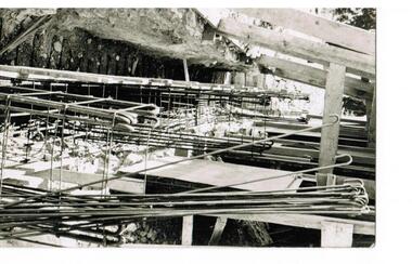
Photograph, Earthquakes: Rebuilding the Church of Taxiarchion, Ithaca, 1953
... Earthquakes: Rebuilding the Church of Taxiarchion, Ithaca ...The 1953 catastrophic earthquakes on Ithaca and nearby Cephalonia caused extensive damage destroying many houses and buildings. The tremors reached 7.2 on the Richter Scale and the devastation was exacerbated by the quake occurring at midday when many people were cooking so fires spread rapidly across the island. The Holy Church of Taxiarchion, located in northern Ithaca on the hill overlooking the village of Platrithia and Afales Bay, was extensively damaged. A committee was formed to rebuild the church and its reconstruction following the earthquake is testament to the determination and resilience of the island's people to overcome hardship and disasters. A black and white photograph of scaffolding supporting a building destroyed in earthquake. A trench along the side of the structure is being prepared for further reinforcement with steel rods before the concrete is poured.The photo a has stamp on the back from the local committee overseeing the rebuilding of the church. It is written in Greek and states the following: REBUILDING COMMITTEE/ HOLY CHURCH OF TAXIARCHES/PLATRITHIA ITHACA. -
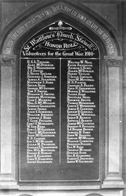 Stawell Historical Society Inc
Photograph, St. Matthew’s Presbyterian Church Honour Roll for the Great War 1914
St. Matthew’s Church Stawell Honour Roll Volunteers for the Great War 1914. Artwork by local Artist Will Rees.Two identical photos of St Matthew's Church Stawell Honor Roll Volunteers for the Great War 1914. Greater Love Hath No Man Then This That A Man Lay Down His Life For His Friends. St. Matthew's Church Stawell. Volunteers for the Great War. 1914. Go the Glory of God.stawell religion church -
 Kew Historical Society Inc
Photograph, Kew Presbyterian Church, c.1959
This work forms part of the collection assembled by the historian Dorothy Rogers, that was donated to the Kew Historical Society by her son John Rogers in 2015. The manuscripts, photographs, maps, and documents were sourced by her from both family and local collections or produced as references for her print publications. Many were directly used by Rogers in writing ‘Lovely Old Homes of Kew’ (1961) and 'A History of Kew' (1973), or the numerous articles on local history that she produced for suburban newspapers. Most of the photographs in the collection include detailed annotations in her hand.The Rogers Collection provides a comprehensive insight into the working habits of a historian in the 1960s and 1970s. Together it forms the largest privately-donated collection within the archives of the Kew Historical Society.Small black and white photograph of Cotham Road, Kew with the Kew Presbyterian Church at right."Presbyterian Church Cotham Rd"kew presbyterian church, churches -- cotham road -- kew (vic.), neo gothic churches, churches -- kew 9vic) -
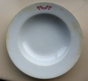 Warrnambool and District Historical Society Inc.
Domestic object - White dinner bowl Plowright's Western Hotel, Grindley Hotel Ware, England, According to date 1913
Charles Plowright operated the Western Hotel on the corner of Timor and Kepler Streets from 1910 until around 1919. It was built in 1869 by William O’Brien, having been designed by Andrew Kerr. It was a staging place for the Cobb & Co Coaches. A common commercial product with which many people could identify. The Western Hotel is a common Warrnambool landmark built around 1869, it was one of the earliest hotels and operates to this day. Plain white soup bowl with flat rim. Red printed logo printed on rim.Plowrights Western Hotel Warrnambool printed in red on rim of bowl. “Grindley Hotel Ware England. Vitrified” stamped on base below emblem of crown. Date stamped in china 1 13warrnambool, plowright, western hotel, grindley china -
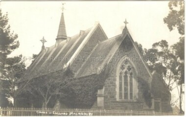 Malmsbury Historical Society
Postcard (Item), Postcard Of St Johns Church Malmsbury C1910 Kodak Postcard, Malmsbury ca1910
... Postcard Of St Johns Church Malmsbury C1910 Kodak Postcard ...Associated with - "Church Of England, Kodak Postcard" Buildings - Church -
 Ringwood and District Historical Society
Photograph, Methodist Church, Heathmont - 30 September 1973, 30/09/1973
Methodist Church, Heathmont - 30 September 1973Written on backing sheet, "Methodist Church, Heathmont - 30.9.73" -
 Melton City Libraries
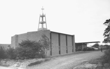
Photograph, Christ Church, Melton, 1970
Photos taken by Wendy Barrie of the interior and exterior including bell tower. These photos were used in its application to National Trust for its classification. Wendy and Edna Barrie. It was eventually dismantled and rebuilt in Wadonga. Efforts were made to save the building. The foundations needed significant work. Many of its adherents were deeply distressed by its loss. It was strongly linked with the Staughton family and therefore of important significance to Melton. Church of England – Christ Church built in 1869 Memorial interior windows of the church local architecture, churches -
 Whitehorse Historical Society Inc.
Photograph, Christ Church Anglican Church, Mitcham, 2012
Christ Church Anglican Church was opened on 7th March 1888. The eight vestry members had to guarantee the minister's stipend of a shilling each Sunday. There was no electricity so kerosene lamps were used. The women ran social evenings, concerts, lanternslide evenings and bazaars to raise funds. The Red Cross used the vestry for their meetings, and the Education Department hired the church for school classes until 1890 when a school was finally erected.Coloured photograph of the original Mitcham Anglican Church in Edward street, with the latest church building in the background - 2012christ church anglican church, mitcham, edward street, whitehorse historical overlay -
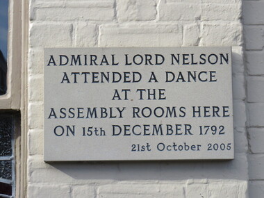 Ballarat Heritage Services
Photograph - Colour, Plaque, Admiral Lord Nelson, Aylsham, England
PLaque at Aylsham, England.aylsham, lord nelson -
 Ringwood and District Historical Society
Photograph, Roman Catholic Church, Bedford Road, Ringwood Vic. - 1970, 1970
Ringwood Roman Catholic Church in 1970Written on backing sheet, "Ringwood R. C. Church. 1.11.70". -
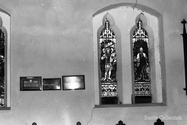
 Glen Eira Historical Society
Album - Album page, St Stephen's Presbyterian Church, Balaclava Road, Circa 1972
This photograph is part of the Caulfield Historical Album 1972. This album was created in approximately 1972 as part of a project by the Caulfield Historical Society to assist in identifying buildings worthy of preservation. The album is related to a Survey the Caulfield Historical Society developed in collaboration with the National Trust of Australia (Victoria) and Caulfield City Council to identify historic buildings within the City of Caulfield that warranted the protection of a National Trust Classification. Principal photographer thought to be Trevor Hart, member of Caulfield Historical Society. Most photographs were taken between 1966-1972 with a small number of photographs being older and from unknown sources. All photographs are black and white except where stated, with 386 photographs over 198 pages. From: Glen Eira Heritage Management Plan (1996) by Andrew Ward and Associates In 1905, the land was vacant in Balaclava Road, north side, from Kooyong Road east to the right of way, except for one house. A block of this land was acquired by the Presbyterian community and a timber church erected there in 1910. In time, a larger church was required. After several years of fund raising led by George Kinross, a new red brick St Stephen's church was built in 1926 to the design of architects Haddon and Henderson. George Currie was the builder and the cost of construction was £5,100.From: Glen Eira Heritage Management Plan (1996) by Andrew Ward and Associates: St Stephens has architectural importance as a noteworthy example of a Gothic Transitional design in the Arts and Crafts eclectic manner (see Stylistic Typology in National Trust's Historic Church's Study}. The facade treatment successfully combines Christian symbols with Gothic forms in the Arts and Crafts mode (comparable with Haddon's Presbyterian Church, Malvern (1906) and Haddon and Henderson's Oakleigh Church (1928). It is locally important as an example of Robert Haddon's work in Caulfield, where he also lived (4 Glenferrie St q.v.).Page 26 of Photograph Album including three black and white photographs of St Stephen's Presbyterian Church, with two photographs in portrait mode across the top showing 2 different stained glass windows from the inside; and one in landscape mode in the bottom section which appears to be a photograph of a framed photograph or drawing of the church.Hand written: St Stephen's Presbyterian Church Balaclava Road [top right] / 26 [bottom right]trevor hart, caulfield north, balaclava road, george kinross, haddon and henderson, george currie, st stephen's, 1900's, 1920's, gothic transitional, christian symbols, arts and crafts, robert haddon, stylistic typology, gothic, drawings, presbyterian church, architects, lead lights, stained glass windows -
Ringwood and District Historical Society
Documents, Teese, Maurice, Life Deacon and foundation member, Short History of Ringwood East Baptist Church for Golden Jubilee 1929-1979, Nov-79
... Short History of Ringwood East Baptist Church for Golden ...Short history of the Ringwood East Baptist Church by Maurice Teese to mark the Golden Jubilee 1929-1979. Includes a list of ministers.Two type-written pages about Ringwood East Baptist Church +Additional Keywords: Teese, Maurice -
 Ballarat Heritage Services
Photograph - Colour, Earth Banks, Old Sarum, England, 2016, 01 November 2016
William the Conqueror inherited Old Sarum from the last Saxon king of England. It was an ideal site for a royal castle. It was here in 1070 that William paid off his army after a long and bitter campaign in northern England. It was here in 1086 that he called together all the major landholders in England so they could swear allegiance to him. It was a crucial moment. The Domesday Book was being written, a threatened Viking invasion had only just been averted and William's eldest son was in armed rebellion. Old Sarum was an important place where this Norman king of England held power. In 1794 the Ordnance Survey set out to check the accuracy of the first mapping of Southern England, which had begun ten years earlier. From a point just below Old Sarum Lieutenant William Mudge laid out a base-line 36,574 feet (11,253 metres) long. From each end of the line the positions of distant places were plotted using a huge theodolite made in 1791 by Jesse Ramsden. The accuracy of the process, which was repeated all over England, depended on Jesse Ramsden's craftsmanship and on William Mudge's surveying skill in setting out this first base-line from Old Sarum. The nearer end of Mudge's line is marked by an inscribed stone beside the modern A345 at Old Sarum. ordnance survey, william mudge, jesse ramsden, william the conqueror, old sarum, saxon, 1086, england