Showing 968 items matching "dam"
-
 Kiewa Valley Historical Society
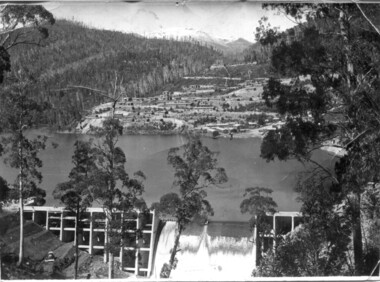
Set of 3 black and white photographs of Lake Guy, Bogong Village and single men's quarters, 1943/44
Construction of Bogong Village was commenced in 1940 and was the Field Headquarters for the early part of the construction of the Kiewa Hydro Electric Scheme. In all, a total of 36 houses, medical centre, police station, trading store and primary school were built. As well, there was a hostel for staff personnel and prefabricated units, each 10 feet x 8 feet, with separate dining and recreational facilities for the worker's. This camp was closed in 1962.These photos show the type of accommodation, available in this period, as well as the benched layout of the village. The damage of the 1939 bushfires is still evident.1. Black and white photo of Junction Dam Wall, Lake Guy and Bogong Village. 2.Black and white photo of single men's quarters at Bogong Village. 3.Lake Guy and Bogong Village.1.Back of photo, Left upper corner - K1334 Upper Right corner - mu (very faint) 6-10-43 2.Back of photo, Left upper corner - K1399 Upper right corner - 14 m 1-2-44 3. Back of photo, left upper corner -K1738 Upper right corner - 145 a mus 5-12-44 bogong village, lake guy, secv -
 Tatura Irrigation & Wartime Camps Museum
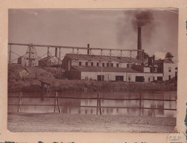
Photograph, Eildon, 1957
Taken by photographer for State Rivers and Water Supply Commission.Large sepia photograph. Featuring huge earthen dam wall middle-right of photo - water in reservoir held back by wall left of middle - hills beyond forming horizon - utility buildings foregroundvictoria state rivers and water supply commission, eildon, eildon reservoir -
 Lakes Entrance Historical Society
Photograph - Costick's Weir, 1999
Built 1942 - 43 to ensure as adequate water supply for fire fighting purposes, after the devastation of the 1939 forest fires. Used by locals as a swimming pool until flooding in the 1980's filled the weir with silt.Colour photograph of Costicks Weir, Old Colquhoun Road, Colquhoun Forest. Shows manmade dam in bush setting. Constructed by building a weir wall across a small natural gorge. Nowa Nowa Victoriavegetation, weir's, local history -
 Wodonga & District Historical Society Inc
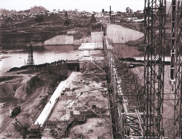
Album - Hume Reservoir Australia Album - View of concrete dam from top of tall tower pillar, August 1927
This set of photos is from a leather bound album bearing the inscription "HUME RESERVOIR AUSTRALIA" plus 'The Rt. Hon. L. C. M. S. Amery, P. C., M .P.' all inscribed in gold. It was presented to The Rt. Hon. L. C. M. S. Amery, P. C., M. P, Secretary of State for Dominion Affairs on the occasion of his visit to the Hume Reservoir on 2nd November 1927. This album is of local and national significance as it documents the planning and development of the Hume Reservoir up to 1927. It was the largest water reservoir in the British Empire. The album records the pioneering engineering work that went into its construction.DEPARTMENT OF PUBLIC WORKS, N.S.W. RIVER MURRAY WATERS SCHEME. HUME RESERVOIR. 29. View from Top of Tail Tower Pillar - Concrete Dam. This was taken from the top of the Tower described in the preceding photograph looking towards New South Wales. (WHS 00722) First is the part of the spillway being built inside the Coffer Dam, then over the Coffer Dam the submerged portion of the Spillway and outlet sections for the river diversion, beyond that the situation for the hydro-electric turbo passages bounded by the North Wing Wall. The gap may be seen in wing wall for the passage of the belt conveyor and half of the concrete mixer house behind. This gives a general view of the New South Wales Township. The Quarry is on the side of the hill showing up beyond the Township. New South Wales, August 1927.hume reservoir australia, river murray waters scheme, hume reservoir construction -
Tatura Irrigation & Wartime Camps Museum
Folder, Irrigation Structures, 1995
Photos of Waranga Basin outlet. Construction of new Torrumbarry Weir 1997 and newspaper report of Hume Dam and other Rural Water information.Grey plastic cover, black spine. Title label insideirrigation, documents, reports, books, history, local, rural, industry -
 Bendigo Historical Society Inc.
Postcard - POSTCARD.OVAL FRAMED LANDSCAPE.BIRTHDAY GREETINGS
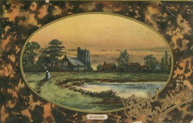
Postcard. Oval framed landscape with church to the left and other housing off centre right, Eventid. Birthday wishes. Two people walking a path to the left. Pond or dam to centre left. Rear. Names deleted. -
 Bendigo Historical Society Inc.
Document - LONG GULLY HISTORY GROUP COLLECTION: BATHS AT LONG GULLY
Copy of an article titled Baths at Long Gully in The Bendigo Independent February 2,. Mr Murray spoke of the deaths which occurred by drowning in dams, which was the only place available bathing in or near Long Gully.bendigo, history, long gully history group, the long gully history group - baths at long gully, the bendigo independent 2 feb, g j murray, t hattam -
Tatura Irrigation & Wartime Camps Museum
Photograph, 1936/02
Photo taken by the photographer for Victoria State Rivers and Water Supply CommissionMedium sized black and white photograph. Eildon Reservoir spillway / Concrete structure centre / rock and earth fill dam wall top half / round concrete tower left midway along wall bank.goulburn, irrigation, photo, victoria state rivers and water supply commission, eildon, eildon weir -
Tatura Irrigation & Wartime Camps Museum
Folder, Yarrawonga Weir Construction 1934-1939, 1994
Photos and newspaper articles on Yarrawonga Wier official opening, 50 years after completionLarge black folder containing photos of construction of Yarrawonga Weir and coffer dam, 1936 and 2 Yarrawonga Chronicle Newspapers. Also has Waranga Basin photo and "Karlsruhe", an historic home at Lancaster. photos (8)books, history, rural, industry, irrigation -
Tatura Irrigation & Wartime Camps Museum
Map - plan, Engineer for Contruction Railways Dept, Toolamba and Tatura Railway, 18 August 1879
Original plan2 sheets stapled together, white paper. Plan of proposed railway line drawn in ink. Names of property owners transverse shown. Roads show. Existing buildings, dams (tanks), wells and railway culverts.Victorian Railways. signed by Engineer in ink.victorian railways plans -
Whitehorse Historical Society Inc.
Pamphlet, Melbourne's water; a community problem, 1968
Collection of papers relating to Melbourne's future water needs by Leigh Blackburn with map extractsCollection of papers relating to Melbourne's future water needs by Leigh Blackburn with map extracts defining the area the author considers the most suitable for the development of future water resources and the dangers of the Lower Yarra Dam proposals.Collection of papers relating to Melbourne's future water needs by Leigh Blackburn with map extracts water supply, melbourne and metropolitan board of works, state rivers and water supply commission, lower yarra dam -
 Rutherglen Historical Society
Image, October 1929
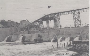
Photocopies of Hume Weir photographs 1928-29One of two black and white photographs, photocopied onto a single sheet of A4 paper. This one is of construction work on a dam, with scaffolding above a partially completed wall. Water is flowing through several valves in the wall.Written on paper next to photo: "Valves etc. at Hume Weir Oct '29"hume weir, construction, dam construction -
University of Melbourne, Burnley Campus Archives
Plan, Rough Interim Plan of Agricultural College Estate Dookie, 1964
Plan of Dookie College showing buildings, numbered paddocks with acreage, other details (windmills, tanks, troughs, dams) named. Key to soil types. Dated April 1964. Scale 1 inch to 28 chains.paddocks, dookie agricultural college, soils, dookie area -
 Ringwood and District Historical Society
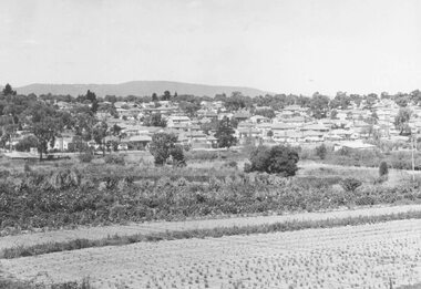
Photograph, New housing developments, New Street, 1960 viewed from railway line near Madden Street looking south-east
Written on back of photograph, "New housing settlement New Street, 1960. From railway line near Madden Street looking south-east. Dam centre foreground". -
Stawell Historical Society Inc
Photograph, Aerial Photos of Stawell from a Hot Air Balloon 1992 -- 12 Photos
Series of 12 Aerial Photos of Stawell. Hot Air Balloon, October 1992 1. Cnr. Maude St & Grant Street 2. Maude St Napier Street & Railway cutting 3. Trotting Track 4. Roundabout Wimmera & Sloane Street 5. Florence Street towards Cato Lake & Park 6. Grampians Range with Lake Lonsdale near center 7. Gold Reef Mall looking West 8. Church Street looking West 9. Looking towards Black Range 10. Moonie Dams Darlington Road Leisure Complex 11. Stawell Gold Mine Evaporations Dams, Stawell Water Reservoirs, Moonie Dams 12. Darlington Road looking towards Black RangeSeries of 12 colour photographs from the Air.stawell -
 Halls Gap & Grampians Historical Society
Photograph - B/W
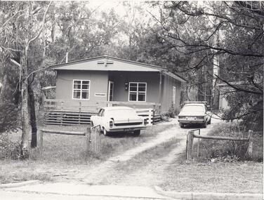
"Yarrabee" a holiday house in Halls Gap which was formerly a staff house for the construction of Bellfield Dam. A number of this houses were transported from job to job.A fibro cement house of simple rectangular construction, a low pitched roof ,sashed windows, a garage appears at the end of the driveway. Two cars are parked in driveway, gum trees surround the house. buildings, houses -
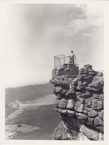 Halls Gap & Grampians Historical Society
Photograph - B/W, C 1960s
Photo is of 'The Pinnacle' lookout with Lake Bellfield in the background flanked by the Mt. William range. the photo is typical of 'tourism' photos taken by the Victorian Railways.Photo shows a man and a woman on top of a rocky outcrop that overlook a valley. A lake with a dam wall and rock tiers cut into the hillside can be seen as well as cleared areas some buildings. the lookout is enclosed with a wire fence.scenery, lookouts -
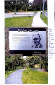 Ringwood and District Historical Society
Photograph, 3 photographs of the Wieland Reserve in Heathmont, Victoria, with notes 2010
Wieland Family were early Orchardists in the Heathmont area.1. Photograph of the Wieland's old horse paddock now Wieland Park' 2. Photograph of the Plaque with Stanley Wieland's image and text of the history of the reserve formerly the horse paddock and dam. 3.Photograph of the. Old house site -
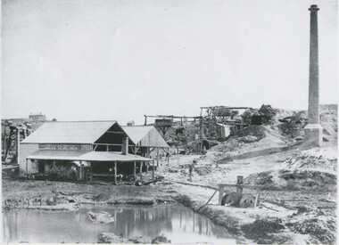 Bendigo Historical Society Inc.
Photograph - MINING LANDSCAPE, 1961
black and white photo: unknown mining site. Left to right, shed with multiple boilers, horse whims with horse ( background ) Chilean mill ( foreground ) Chimney. In foreground, dam with 'filter' Substantial house ( stone ? ) on hill in distance.Batchelder, Sandhurstplace, landscape view, mining site -
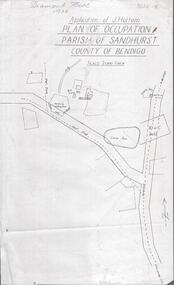 Bendigo Historical Society Inc.
Photograph - DIAMOND HILL 1936, PLAN OF OCCUPATION
Print of 'Application of J. Hattam, plan of occupation parish of Sandhurst, County of Bendigo' Plan shows Post Office site, large dam, 'formerly cultivated site near Post Office'. A un-named gully is marked.bendigo, mining, diamond hill -
 Bendigo Historical Society Inc.
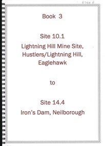
Book - LIGHTNING HILL MINE SITE HUSTLERS LIGHTNING HILL EAGLEHAWK TO IRON'S DAM NEILBOROUGH, 1992
Book 3, Site 10.1, Lightning Hill Mine Site, Hustler's/Lightning Hill, Eaglehawk to site 14.4, Iron's Dam, Neilborough. Contains significance reports prepared for North Central Goldfields Project: Bendigo Goldfield.David Bannearbendigo, mining, goldfields reports, bendigo, gold, goldfields, history, reports -
 Bendigo Historical Society Inc.
Slide - DAVID MCDONALD COLLECTION: EPPALOCK. CONSTRUCTION, c1963
Eppalock. Construction. Lake appears to be full or close to it with beautiful blue water. The bank to the left is the bank which the road goes across, the walkway out to the water tower and the water tower. Markings: Eppalock Dam March 1963.Kodakcivil engineering, water supply, eppalock -
Tatura Irrigation & Wartime Camps Museum
Photograph, 1936
Photo taken by the photographer for Victoria State Rivers and Water Supply CommissionMedium sized black and white photograph. Eildon Reservoir dam wall / rock and earth fill wall from above / round concrete tower lower left / water above right / tree covered hill topgoulburn, irrigation, photo, victoria state rivers and water supply commission, eildon, eildon weir -
 Southern Sherbrooke Historical Society Inc.
Photograph - Cardinia Reservoir filling, post 1973, Narre Warren East area
A set of five colour photos showing Cardinia Dam beginning to fill after its completion in 1973. One photo shows smoke or possibly dust rising on a distant hillside. The set was donated to the society by David Howe. -
 Buninyong & District Historical Society
Photograph - Original Colour Photograph, Clive Brooks, View of The Gong, looking South East, 1982
Record of Gong 1980's.Colour photo, view looking S.E. of the Upper Dam, also known as The Gong,. Buildings, upper left hoiuse of T. Attwood, Market Gardener, 1860; Centre bluestone former brewery 1854 and behind extension 1980.gong, reservour, brewery, attwood -
 Bendigo Historical Society Inc.
Map - SNOB'S HILL - PLAN OF SNOB'S HILL AREA
Plan drawn on tracing film of sand heap, dams, trig point and mines. Some un-named streets are also drawn in. Piece of notepaper has mines drawn in on a larger scale. Notes prepared by Albert Richardson.map, bendigo, goldfields, snob's hill, plan of snob's hill area, new st mungo mullock heap, duchess trib, s devonshire, duchess of edinburough, w u devonshire, hopewell, phoenix, unicorn, princess alice, lady barkly, sadowa, e u devonshire, united devonshire, l?, ellenborough, belmont & saxby, snob's hill -
 Melbourne Water
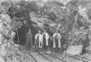
Photograph - Tunnel at the O'Shannasy Dam, 9th April 1921
The O'Shannassy Reservoir supplies water to the Silvan Reservoir, which distributes it to most parts of Melbourne. The dam was completed in 1928 and is an earthfill embankment with a reinforced concrete core wall.This photograph is significant as it provides a detailed insight into the Boards activity and construction of one of Melbourne's most important water supply systems. Furthermore, it is of historical importance to the history of Melbourne while it is representative of shaping Melbourne's environments, transforming and managing land and natural resources, and providing urban infrastructure and services. This photograph also covers the theme of Safety, depicting the safety standards of the time particularly with clothing. Black and white photographmmbw, melbourne metropolitan board of works, melbourne water, silvan reservoir, o'shannassy reservoir, construction, work, men, infrastructure -
 Bendigo Historical Society Inc.
Photograph - VIRGINIA MINE, EAGLEHAWK
Black and white photo: Virginia Mine, Eaglehawk, crushing battery in foreground, dam in immediate front of photo. Chimney on RH side of photo, behind crusher. Overhead railway runs through middle photo, poppet head in background.organization, business, virginia mine, eaglehawk -
 Bendigo Historical Society Inc.
Slide - DAVID MCDONALD COLLECTION: EPPALOCK. CONSTRUCTION, c1962
Eppalock. Construction. The lake is now filling, the fence line and the road disappear down into the lake. Near the water there is a ''Road Closed sign''. To the left of the road there are two old sheds. Markings: Eppalock Dam, Dec 1962 near Lyal.Kodakcivil engineering, water supply, eppalock -
 Bendigo Historical Society Inc.
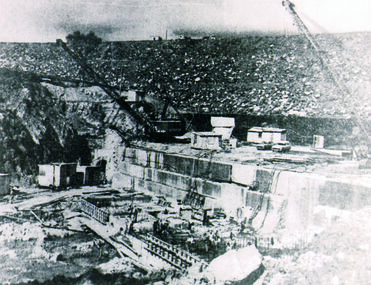
Photograph - BUILDING EPPALOCK WALL - 1962, 1962
Black and White Photo from the 'Bendigo Advertiser' was taken in 1962, it shows the construction of the Eppalock Wall - Eppalock Dam, Markings on photo read 'from Bendigo Advertiser 1962' 'Building Eppalock Wall'. A crane at each end of the structure.place, eppalock wall, eppalock wall, buildinmg eppalock wall, eppalock dam, eppalock