Showing 524 items
matching department of lands
-
 Kiewa Valley Historical Society
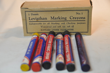
Box Crayons Marking, circa mid to late 1900's
These type of marking crayons have been in use from the 1800s onward to mark commercial and non commercial goods and articles that require waterproof and visual identification labels. Items such as bales of wool, tobacco tags, transportation tags(shipping, rail and road) and other "hard to mark" items that require information to be displayed by semi permanent waterproof signage. The crayons are also an advantage for young student art work.This particular box of leviathan crayons was in use by students in the Mount Beauty Primary School through the Victorian Education Supply Department. As the texture and adhesive/application qualities (soft medium and hard) allows students to be "creative" on various type of canvases. This type of application in schools is of a non commercial and simplistic art -form nature however more advanced students could present a commercial interest in a viable creative artistic venture. The major commercial and non educational uses are encompassed in a rural grazing and farming regions, of the Kiewa Valley and adjoining lands.The crayon box is made from cardboard and light buff colour. The box contains six "No.1" crayons, two of which have been used. Each crayon is wrapped with manufacturer's details on 180 gsm thick paper. The wrapper runs nearly 4/5 th of the entire length, leaving 1/5th open to display the colour of the crayon. The colours of the crayons are blue, purple, green, yellow, red and black. These crayons provide a waterproof writing, sketching and numbering method and are available in soft, medium and hard texture.Within a chain border and on two opposite sides of the box: "1 Dozen No.1", and below this and underlined "Leviathan Marking Crayons" and below this "Indispensable for all Marking and Checking purposes Waterproof and will not rub off", below this "SUPPLIED UNDER GUARANTEE"waterproof, freehand marking and artworks, school waterproof art, commercial identification marking of rural produce, school art, waterproof labelling -
 Eltham District Historical Society Inc
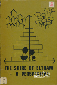
Book, Shire of Eltham, The Shire of Eltham - A Perspective, July 1981
This report was produced by the Shire of Eltham (Planning Department) following a population study of the Shire. It also includes other areas of general interest. The Document contents includes Present and Future - Population - Housing - Residential Lands - Social Characteristics - Development and History. Includes maps, tables and diagrams. Part 1: The Existing situation - introduction, the Shire of Eltham, physical characteristics, historical development, population growth. Characteristics of the population - size and distribution, age / sex, natural increase, migration. Socio-Economic Factors: socio-economic status, employment/workforce, education, other social factors. Housing/ building statistics: characteristics of Housing stock, current residential trends, other types of building activity. Residential Land: existing vacant lots, estimated additional lots. Part 2: The Future. Land availability, the future population.The Shire of Eltham Council resolved on publication of this report "to commend it to the ratepayers as a most valuable resource document". It provides a comprehensive statistical review of the Shire of Eltham, Victoria in 1981 with some population and development predictions for the future.Spiral bound, soft cover, includes indexBarcode and identification markings including stamped "WITHDRAWN" from Heidelberg Regional Library Serviceshire of eltham, planning, population -
 Warrnambool and District Historical Society Inc.
Document - Ledger: Warrnambool Shire Letter book 1861-1865, Circa 1860
Contains correspondence pertaining to matters of infrastructure in the period of the 1860’s. The period contained within this ledger is very early in the establishment of the district. It shows the co-operation and initiative between councils, government departments and individuals in matters relating drainage, bridges , roads all vital to the development of the region.Fawn cloth on card cover with tan corner and spine binding. Contains alphabetical index at the front. Letters are written on very fine paper.: On the spine is a paper label, “January1861-April 1865.Label inside front cover “Sands &Kenny. Account Book Manufacturers, Stationers &Printers, Collins St Melbourne. The index contains the following names :W G Allan, Bostock, Biggs, Bench of Magistrates Caramut, Niel Black, Commissioner of the Crown Lands Warrnambool, Commissioner of Roads and Bridges, Cross, Carr, Duffy, Davies, Duffus, Fitzmaurice, Horace Flower warrnambool, warrnambool shire, tenders, district roads board, a davies, 1861-1865 -
 Federation University Historical Collection
Book, Victorian Government Legislative Assembly, The Select Committee on Castlemaine and Sandhurst water supply, Report from the Select Committee on Castlemaine and Sandhurst Water Supply, together with the proceedings of the Committee, minutes of evidence and appendices, 19/5/1865 (exact)
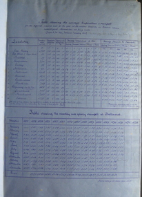
This book contains the report from the select committee on Castlemaine and Sandhurst water supply; with the proceedings of the committee, minutes of evidence and appendices. It also contains the report Of the Engineer-In-Chief of Railways, and reply of the Chief Engineer of Water Supply on the works constructed by the Victorian Water Supply Department, presented to both houses of parliament by His Excellency’s command. Ferdinand M. Krause, was a lecturer at the Ballarat School of Mines in Geology Mineralogy Mining Engineering and Surveying. He was a Fellow of the Geological Society and a Fellow of the Linnian Society. He was assistant engineer for the Ballaarat and Ballarat East Water Supply Committee and helped plan local reservoirs.A brown cloth hard cover, foolscap book with leather spine. Title is written in black on the title page. "Water Supply Reports" is engraved in gold on spine. It includes a table showing the monthly and yearly rainfall and shade temperature at Ballarat, 2nd February, 1885. It also includes two reports and two replies, a map No.7082.2 of Victorian Water Supply, Castlemaine and Sandhurst district general plan including lines of Aqueduct, Reservoirs. No. 7082.3 of Victorian Mining districts, Mining Divisions and The Gold Fields in 1866 - includes districts to be supplied under the Waterworks Act, 1965. It also includes: *Report of the Engineer-in-chief of Railways and Reply of the Chief Engineer of Water Supply on the works constructed by the Victorian Water Supply Department, 1869. * Coliban Water Scheme, 1864 * Ballarat and Ballarat East Water Supply (1869) including the Ballarat Water Supply List containing names of occupiers and nature of improvements on lands comprised within the proposed reserve of Gong Gong Reservoir, Ballaarat. At Warrenheip the names included: Honora McCallin, William Honan, C. McMahon, Patrick McMahon, J.P. Beach, J.H. Smith, Michael Nestor, Martin Quinn, Martin McIntyre, Robert Higgins, Coleman Kane, Robert Bond. At Ballarat: William Clarke, Richard White, John Hosking, Wesleyan Chapel, J. Hewitt, Robert McRobinson. At Bungaree: John Pullin, John Llewellyn. William Daw, Smith and Wynne, William Brough, A. Alexander. * Ballarat and Ballaarat East Water Supply report upon the advisability, or otherwise, of constructing a reservoir at the junction of the Yarrowee Creek and Gile's Creek, upon a site known as Gile's Reservoir (printed by Frank Pinkerton). This report has numerous notes written on it (most probably by Krause) and includes the capacity of Harry Beale's Reservoir, Pimcott's Reservoir and the Proposed Gong Gong Reservoir. * Statement as to the position of the Ballaarat and Ballaarat East Borough Councils in Connection with Water Supply, September 1869. * Ballarat and Ballaarat East Water Supply - General Statement upon the Ballaarat and Ballaarat east Scheme of Water Supply. Includes information on Moorabool reservoir, Harry Beale's Reservoir, Lal Lal Creek, Two Mile Creek, Beale's Dam, Yarrowee Creek, Gong Gong Reservoir, Kirk's Dam, Devil's Creek, Moorabool Creek. Additional handwritten notes (probably by Krause) * Engineer's Report on the resolution of the COmmittee of Water Supply, of the 7th July 1868. The report refers to the Country around Mount Warrenheip. Names mentioned are L. Abraham, Great North-West Gold Mining Company, Border Sawmills, Ferdinand Krause, Ohlfsen Bagge, W.H. Shaw, A signature by "Ferdinand M. Krause" at the top corner of the title page. A few pages have handwriting on the margins, it is believed to be his handwriting. water supply victoria, castlemaine directories, sandhurst directories, ballarat directories, james blackburn, edward wardle, daylesford water race, c j taylor, george avery fletcher, bagge, ohlfsen bagge, george foote, john h reilly, ambrose johnson, george francis, timber preservation, james forbes, alfred surplice, malcolm carmichael, robert adams, frederick hugh thomas, h o christerpherson, william downe, thomas lawrence brown, francis hadgson nixon, strangways, guildford, maldon, muckleford, lauriston, malmesbury, franklinford, walmer, strathloddon, downe, ferdinand krause, m7082, trentham, castlemaine, drummond, metcalfe, sutton grange, lockwood, ravenswood, mandurang, yandoit, c.h. ohlfsen bagge, moorabool reservoir, gong gong reservoir, harry beale's reservoir, pincott reservoir, frank pinkerton, water -
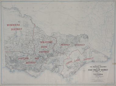 Federation University Historical Collection
Plan, Map Showing the Pastoral Holdings of the Port Phillip District 1835-1851 Now Victoria, 1932, 1932
... Crown Lands Department... Alfred Stephen Kenyon Crown Lands Department H.J. Green ...Another name for Pastoral Holdings is squatting runs. Information on Alfred Stephen Kenyon of the Historical Society of Victoria can be found at http://adb.anu.edu.au/biography/kenyon-alfred-stephen-6936/text12035 Map of Victoria showing the boundaries of the Port Phillip District (Victoria) pastoral boundaries. pastoral holdings, squatters, squatting, victoria, land, crown lands, a.s. kenyon, alfred stephen kenyon -
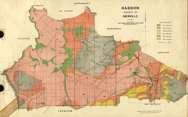 Federation University Historical Collection
Plan, Haddon, County of Grenville, 1887, 1889
... Crown Lands Department Melbourne...Crown Lands Department Melbourne... Crown Lands Department Melbourne Ferdinand M. Krause Crown Lands ...Ferdinand Krause taught at the Ballarat School of MinesGeological Map of Haddon in the County of Grenville surveyed by Ferdinand Krause. haddon, grenville, krause, ferdinand krause, cgt, lake burrumbeet, windermere, chepstowe, bailies creek, snake valley lead, nentingbool preemptice right, cardigan state forest, haddon state forest -
 Federation University Historical Collection
Plan, Scarsdale County of Grenville, 1889, 26/01/1889
Rectangular plan of a geological survey edged in masking tape. It is predominantly grey, pink and green, but has some yellow. scale is 40 chains to one inch. (see Cat. No. 1098 for report on the Parish of Scarsdale)scarsdale, grenville, krause, browns and scarsdale, mopianimum, watershed, yarrowee, woady yalloak, timber reserve, department of mines, plans, cgt, crown lands, ferdinand krause -
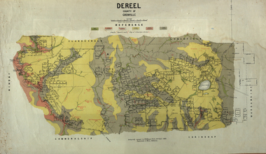 Federation University Historical Collection
Map, Dereel, County of Grenville, 1890, 1890
... crown lands department...Crown Lands Department... is in western Victoria. dereel ferdinand krause crown lands department ...Dereel is in western Victoria.Geological map of Dereel in the County of Grenville featuing six colours (predominantly grey and yellow). WGS 84 Centroid Lat: 37 degrees 48 feet 50 inches S Long:143 degrees 42 feet 10 inches S N-S: 6.4 km E-W: 15.2 km dereel, ferdinand krause, crown lands department, plan -
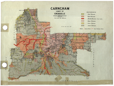 Federation University Historical Collection
Plan, Carngham, County of Grenville
... Crown Lands Department Melbourne..., Victoria. Carngham, County of Grenville Plan Plan Crown Lands ...A plan of Carngham, Victoria.snake valley, timber reserve, poverty point, recreation reserve, carngham, county of ripon, county of grenville, plan -
 Federation University Historical Collection
Document - Reports, Martin Westbrooke, Nanya Station
Nanya Station, owned and managed by the University of Ballarat (now Federation University Australia), was purchased with assistance from the Department of Environment and Heritage Government Caring for our Country program. Nanya Station is located in the Scotia country, west of the Darling Ana-Branch in far western New South Wales and consists of the Nanya Western Lands Pastoral Lease 3281 – Perpetual Leasehold Lot 1244 in Deposited Plan 762778, Parish of Winnebaga, County of Tara and part of Lot 1242 County of Windeyer. Nanya is within the tribal area of the Danggali Aboriginal people, a sub-group of the Barkindji. Many Aboriginal sites have been recorded adjacent to major rivers in the region providing evidence that these areas supported a large population. The Scotia region has one of the shortest stock grazing histories of western NSW. Along with five other Scotia properties, Nanya was created as a pastoral lease in 1927. The first European settlement on the land followed exploration of the area by Sturt and Eyre. In 1854, the Lake Victoria lease which encompassed this area comprised 465,000ha.included Scotia blocks 1, 2, 3 and 4, Amoskeag and Winnebaga which formed the area known as the Scotia. It was described as a region of thick mallee scrub, interspersed with bluebush flats and Belah woodland. In the 1920s artesian water was found and the dry Scotia country was surveyed and divided into six Homestead leases allocated by ballot (Withers 1989). All properties were approximately 30,000ha, with a recommended stocking level of 3,000 sheep. Winnebaga (renamed Nanya) was taken up by Gordon Cumming. He initially dug a dam near the southeast corner of the property. A larger ground tank and rudimentary dwelling at the site of the present complex was later established. An adjacent area was cleared and cropped to provide feed for the horses used in digging the earth tanks. The ruins of the original building are located between the shearing shed and Homestead Tank. A cottage was built in the 1930s and a more substantial Red Gum framed homestead in the early 1950s. The lease was held by Mr Gordon Cumming until 1984 when it was purchased by Mr Norm Scadding as an extension to the adjacent lease, Belvedere. It was sold in 1995 to Mr Rob Taylor of Waikerie then in 1999 to BeMax Pty. Ltd., a sand mining company. These last three owners all permitted use of the property by the University for teaching and research. The Centre for Environmental Management at the University of Ballarat had been involved in studies of flora and fauna in western New South Wales since 1988. Studies became concentrated on the Scotia region with its variety of intact ecosystems due to a short pastoral history. Of particular significance is a system of natural salt lakes of which the most extensive is the Scotia Discharge Complex located on Nanya Station. An extensive vegetation survey of the Scotia region Westbrooke et al. 1998) highlighted the significance of the area both in terms of the range of communities in relatively intact condition and the occurrence of species and communities of restricted distribution. Nearly 400 species were recorded of which nine had either not previously been recorded or have restricted distribution in western NSW. Twenty-two plant communities occur on Nanya Station of which two, Halosarcia lylei low open shrubland and Hemichroa diandra/Halosarcia/Frankenia low open shrubland, are dominated by species not previously recorded from NSW. H. lylei and Acacia loderi shrublands are listed as endangered under the NSW Threatened Species Conservation Act. As noted, the area has a relatively short grazing history and, due to the presence of large areas of mallee with a Triodia understorey and restricted water supplies, stocking rates have been low. The diversity of ecosystems in relatively intact condition and extensive areas of old growth mallee made Nanya a highly significant refuge for biological diversity. This factors led to the purchase of Nanya Station by the University of Ballarat in 2004 with the assistance of the Department of Environment and Heritage for the purposes of conservation, research and education. In 2010 the southern paddocks of Nagaella Station (10,000ha.) which lie along the northern boundary, were purchased with the assistance of Lower Murray Darling Catchment Management Authority and added to the Nanya lease to provide complete protection for the communities of the Nanya Discharge Complex and further high quality Malleefowl habitat. Four digital reports documents relating to Federation University's Nanya Station, Western New South Walesnanya station, scotia country, pastoral lease, winnebaga county, darling ana-branch, martin westbrooke, environmental education, nagaella station, lower murray darling catchment management authority, conservation research education, ian gribble, pat prevett, ian henderson, danggali -
 Federation University Historical Collection
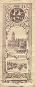
Map, Ballarat and Creswick Districts, 1917, 14/03/1917
... of Lands, at the Department's request, for the cover of a tourists... "... Three designs have been submitted to the Minister of Lands ..."... Three designs have been submitted to the Minister of Lands, at the Department's request, for the cover of a tourists' Guide book of the Ballarat and Creswick Districts. ..." (Ballarat School of Mines Principals Monthly Report, August 1916. Cat. No. 1110.12)A folded map of Ballarat and Creswick Districts which includes tourist destinations such as Creswick, Eureka Stockade, Sturt Street and Coliseum. Drawings are by Amalie Feild.ballarat, creswick, feild, amalie feild, ballarat town hall, park lake creswick, eureka memorial, university women -
 Federation University Historical Collection
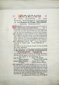
Certificate, Ballarat School of Mines Endowment Plantation, Nerrina Covenant, c1958, c1958
Throughout the Nerrina district numerous areas of public land were set aside as school endowment plantations as part of various schools’ educational resources. The plantations were initially established to instil through community involvement a love of forests and an appreciation of their value, and in fact many of them are well suited for regular use as a teaching resource of this nature. It was expected that this use will increase as courses embracing various aspects of environmental science are developed. Many school plantations have been planted to radiata pine, and revenue from the sale of produce used to provide amenities required by the schools. In some cases, however, these plantations have not been very successful in providing revenue, as the sites are unsuitable for economic growth or the plantations are too small or the location too far from processing centres to allow economic harvesting. In some instances, radiata pine plantations have failed due to poor management. In 1982 the Land Conservation Council believed that all the existing plantations should be assessed in order to establish their value as a teaching resource. Those not needed or that are unsuitable for teaching purposes for some reason, such as their location, should be terminated. Those planted to radiata pine that have limited value as a teaching resource although satisfactory for wood production may continue to be used for such production, but should be reviewed when the pines are harvested. (http://www.veac.vic.gov.au/reports/354-Ballarat-Study-Area.pdf, acccessed 30/03/2017) The School Endowment Plantation Scheme was established in 1922 as a joint venture between the Education Department and the FCV. It was administered by the Education Department with technical supervision by the Commission. While some plantations were established on private land donated or leased for the purpose, most were established on Crown Lands or Reserved Forest made available, without cost, by the State. (https://www.victoriasforestryheritage.org.au/community/schools.html, accessed 26 September 2020)Covenant in the matter of the School Endowment Plantation of the School of Mines Ballarat School Community.nerrina pine plantation, ballarat school of mines endowment plantation, nerrina, pine plantation, nerrina, john r. lyall, richard w. richards, dick richards, edgar j. tippett, charles h. clamp, alfred k. mcbain, endowment plantation -
 Federation University Historical Collection
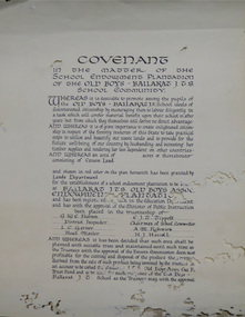
Certificate, Ballarat Junior Technical School Old Boys Association Endowment Plantation, c1928, c1928
The School Endowment Plantation Scheme was established in 1922 as a joint venture between the Education Department and the FCV. It was administered by the Education Department with technical supervision by the Commission. While some plantations were established on private land donated or leased for the purpose, most were established on Crown Lands or Reserved Forest made available, without cost, by the State. (https://www.victoriasforestryheritage.org.au/community/schools.html, accessed 26 September 2020) Throughout the Nerrina district numerous areas of public land were set aside as school endowment plantations as part of various schools’ educational resources. The plantations were initially established to instil through community involvement a love of forests and an appreciation of their value, and in fact many of them are well suited for regular use as a teaching resource of this nature. It was expected that this use will increase as courses embracing various aspects of environmental science are developed. Many school plantations have been planted to radiata pine, and revenue from the sale of produce used to provide amenities required by the schools. In some cases, however, these plantations have not been very successful in providing revenue, as the sites are unsuitable for economic growth or the plantations are too small or the location too far from processing centres to allow economic harvesting. In some instances, radiata pine plantations have failed due to poor management. In 1982 the Land Conservation Council believed that all the existing plantations should be assessed in order to establish their value as a teaching resource. Those not needed or that are unsuitable for teaching purposes for some reason, such as their location, should be terminated. Those planted to radiata pine that have limited value as a teaching resource although satisfactory for wood production may continue to be used for such production, but should be reviewed when the pines are harvested. (http://www.veac.vic.gov.au/reports/354-Ballarat-Study-Area.pdf, acccessed 30/03/2017)Covenant in the matter of the School Endowment Plantation of the Ballarat Junior Technical School Old Boys Association Endowment Plantation.pine plantation, alfred k. mcbain, g.w.e. pearson, i.c. garner, a.m. robinson, h.j. hassell, ballarat junior technical school old boys association endowment plantation, ballarat junior technical school, alumni -
 Federation University Historical Collection
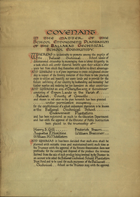
Certificate, Ballarat Technical School Endowment Plantation, 1928, 1928
The School Endowment Plantation Scheme was established in 1922 as a joint venture between the Education Department and the FCV. It was administered by the Education Department with technical supervision by the Commission. While some plantations were established on private land donated or leased for the purpose, most were established on Crown Lands or Reserved Forest made available, without cost, by the State. (https://www.victoriasforestryheritage.org.au/community/schools.html, accessed 26 September 2020) Throughout the Nerrina district numerous areas of public land were set aside as school endowment plantations as part of various schools’ educational resources. The plantations were initially established to instil through community involvement a love of forests and an appreciation of their value, and in fact many of them are well suited for regular use as a teaching resource of this nature. It was expected that this use will increase as courses embracing various aspects of environmental science are developed. Many school plantations have been planted to radiata pine, and revenue from the sale of produce used to provide amenities required by the schools. In some cases, however, these plantations have not been very successful in providing revenue, as the sites are unsuitable for economic growth or the plantations are too small or the location too far from processing centres to allow economic harvesting. In some instances, radiata pine plantations have failed due to poor management. In 1982 the Land Conservation Council believed that all the existing plantations should be assessed in order to establish their value as a teaching resource. Those not needed or that are unsuitable for teaching purposes for some reason, such as their location, should be terminated. Those planted to radiata pine that have limited value as a teaching resource although satisfactory for wood production may continue to be used for such production, but should be reviewed when the pines are harvested. (http://www.veac.vic.gov.au/reports/354-Ballarat-Study-Area.pdf, acccessed 30/03/2017) Three A3 page covenant outlining the 35 acres of Crown Land in the Parish Of Ballarat, County of Grenville, to be granted under permissive occupancy for the establishment of a school plantation to be known as the Ballarat Technical School Endowment Plantation, and two letters relating to same, one on green paper. The Ballarat Technical School Endowment Plantation was at Vale Park, Ballarat. Vale Park is near Norman Street, Ballarat. pine plantation, ballarat junior technical school, alumni, ballarat technical school, ballarat technical school endowment plantation, harry s. gill, augustine f. hesiltine, william h. middleton, frederick brawn, william brazenor, a.w. steane, j.b. robinson, vale park, lindsay hillman, a.j. sutherland, oliver r. roberts, w.a. richardson, w.i. watson, j.g. hopwood, g.f. rumpff, e.j. dalker, john b. colbourn, jack r. collins -
Federation University Historical Collection
Reports, Unidentified Mammal Report, 1970-1990, 1970-1990
The folder or correspondence is the result of a Freedom of Information request made to the Department of of Conservation, Forests and Lands in 2011. The folder was collected for research being conducted by David Waldron.Folder of reports relating to "Big Cats", Thylacines, and other large predators sightings australian mythical animals collection, david waldron, thylacine, sassafras, peter monhorst, jodie hoey, kelvin smith, traralgon south, gormondale, bridgewater, g. mcclure, whorouly, albury, jim walker, andrea westcott, john dawson, nicole walsh, grampians, eddy scott, talbot, lancefield, kalorama, inglewood, gavin cerini, dereel, rosemary fernandez, brian walters, alexandra, unidentified mammel, romsey, bill butterworth, flowerdale, bob hoare, trafalgar, lyn demopolis, broadford, green gully, ian weir, noel pascoe, bruce carter, mount stirling, andrea cooper, stawell, yvonne shepherd, red hills, halls gap, jill reid, puma, w.r.c. hill, caelli -
 Federation University Historical Collection
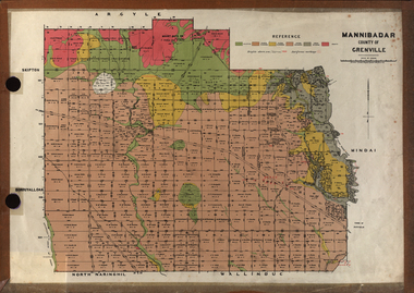
Plan, Mannibadar Geological plan
... Crown Lands Department.... Mannibadar Geological plan Plan Crown Lands Department ...Coloured plan of Mannibadar, County of Grenville.mannibadar, pitfield, mount bute, emu hills, woady yalouk river, geology, plan -
 Federation University Historical Collection
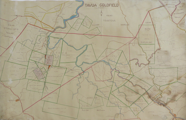
Plan, Tavua Goldfield, 1935
... lands department fiji... goldfield tavua lands department fiji Printed plan with coloured ...Printed plan with coloured shading of Tavua Goldfield tavua goldfield, tavua, lands department fiji -
 Federation University Historical Collection
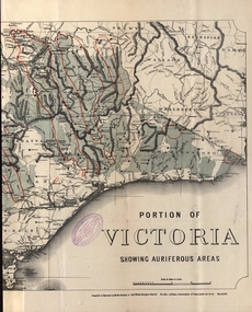
Map - Map and Information, Department of Mines: Map and Suggestions to Prospectors, 1891
The map outlines the auriferous (gold bearing) areas in Victoria. The information for prospectors was prepared by the Department of Mines in 1894Document: 4 page type written Map: Portion of Victoria divided into Counties of 1891. Auriferous areas with red.Reference section on mapgold, auriferous areas, department of mines, victoria, map of victoria, prospectors, commissioner of crown lands, hon a mclean, alexander black, surveyor general, a mclean -
 Bendigo Historical Society Inc.
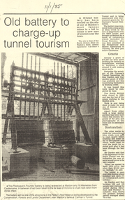
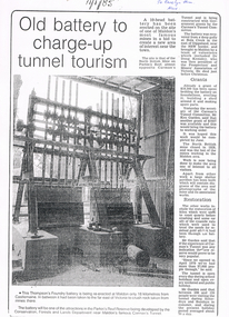
Document - LONG GULLY HISTORY GROUP COLLECTION:OLD BATTERY TO CHARGE-UP TUNNEL TOURISM
... Conservation Forests and lands Department... Foundry Parkin's Reef Reserve Conservation Forests and lands ...Photocopy of a newspaper article titled Old battery to charge-up tunnel tourism. There is a photo of a Thompson's Foundry battery which is being re-erected at the site of the North British mine on Parkin's Reef, near Carman's tunnel. The battery was recovered from a deep gully at Bola Creek. Other works include restoration of quartz roasting kilns and cyanide vats. Written at the top of the article is a date 11/1/85.bendigo, history, long gully history group, the long gully history group - old battery to charge-up tunnel tourism, thompson's foundry, parkin's reef reserve, conservation forests and lands department, carman's tunnel, north british mine, carman's tunnel committee, dr doug kemsley, the prospectors' and miners' association of victoria, mr ken garden -
 Bendigo Historical Society Inc.
Book - DEPARTMENT OF AGRICULTURE SECOND ANNUAL REPORT 1874
Dark green cover, embossed on front 'Department of Agriculture Victoria' enclosed in circular design. Report to the Minister of Lands and Agriculture, 1874 on the proceedings of the Department, 363 pages. Written on front page in black ink "Mr H.P. Smith, Strathfieldsaye' Includes information on agricultural education, Australian grasses, diseases among stock, orange cuture, wood boring beetles, apples meteorologyof Victoria, worm diseased in sheep, sericulture, white eyebrowed woodswallow, flax, vines and wine industry, fencing and impounding. Contains information about Strathfieldsaye vigneron Messrs Bruhn and T Strachan of Axedale. Extensive metereological data for 1873 included; Sandhurst data described in depth.Variousgovernment, state, department of agriculture -
 Bendigo Historical Society Inc.
Newspaper - LONG GULLY HISTORY GROUP COLLECTION: 10 HEAD BATTERY
... Conservation Forests and Lands Department... Reserve Conservation Forests and Lands Department Carman's Tunnel ...Copy of a newspaper article titled Old battery to charge-up tunnel tourism. Date written on the paper is 11/1/85. The Thompson's Foundry Battery was re-erected in the Parkin's Reef Reserve after being used at Bola Creek near the NSW border. A team of volunteers and a Grant had it moved to Maldon where it was set up and the area made attractive for tourists.bendigo, history, long gully history group, the long gully history group - 10 head battery, thompson's foundry battery, parkin's reef reserve, conservation forests and lands department, carman's tunnel, north british mine, parkins reef, carman's tunnel committee, dr doug kemsley, prospectors' and miners' association of victoria, mr ken garden -
Bendigo Historical Society Inc.
Newspaper - OLD VIOLET SHAFT - THE OLD VIOLET STREET MINE
... Lands Department... Mines Department Mr Frank Vincent Lands Department Senior ...Newspaper article titled 'Volcano' gives the Mines Department Problem. Bendigo Advertiser dated Friday, May 12, 1967. Mine was still burning and the ground had subsided four feet more. It would be a matter of waiting until the smoke diminished and how far the ground was going to subside. Until then it would be useless to do anything. Sawdust had been dumped in the shaft, on top of the concrete slab. There was still the concern for the local children.newspaper, bendigo advertiser, old violet shaft, old violet shaft, the old violet street mine, bendigo advertiser friday may 12 1967, mines department, mr frank vincent, lands department, senior constable p meaney, cr r f turner, violet street state school, mr a marshall, mr f turner, p hopley -
Bendigo Historical Society Inc.
Document - HARRY BIGGS COLLECTION: OLD POLICE BARRACKS, 5/6/70
Document. Harry Biggs Collection. A letter on Public Works Department Victoria letterhead from G. Serpell Director General to Mr H. Biggs, Treasurer Royal Historical of Victoria (Bendigo Branch) dated 5th June 1970. In the letter he is stating The Depart. Of Crown Lands & Survey is investigating the future use & control of the old Police Barracks building.G. Serpell Director Generalorganization, club/society, community, harry biggs collection, old police barracks -
 Bendigo Historical Society Inc.
Document - THE BENDIGO GOLD DISTRICT GENERAL HOSPITAL
... Lands Department... Church of England MR J H Walker Dr Childs Dr Stuart Lands ...Typed notes on the beginnings and building of the Bendigo Hospital. Written by Mary Fry and dated Oct 1981. It also tells of the expansion and of vegetable growing in the grounds. Also included is a Report from the Australian Medical Journal (April, 1857) on Quacks, Board of Management 1853 and a bibliography.document, the bendigo gold district general hospital, mary fry, mrs clancy, james lawrence, dr wall, dr edward hunt, mr g f walter, first church of england, mr j h walker, dr childs, dr stuart, lands department, vahland and getzschmann, mr john o'shannassy, governor sir henry barkly, mr h trumble, policeman pat ryan, mrs a watson, benevolent asylum, easter fair society, mr j h abbott, lady bowen, george mackay, annals of bendigo, k m bowden, mr lazarus, f mcmahon, training school for nurses, nurses' home, bendigo and northern district base hospital, australian medical journal, rev dr backhaus, gregory, searle, raston, butler, drs mrcrea, tierney, e r jones, wall, roche, smith, barnett, messrs mclachlan, wilkinson, o'connor, emmett, fraser, wollaston, burrell, garsed, edhouse, snowdon, miss w stock, william howitt, w b kimberly, j n mackartney, frank cusack, william perry, geoffrey serle, james smith, the argus, bendigo advertiser, bendigo independent, mount alexander mail, the sandhurst bee, a lady's visit to the gold diggings of australia 1852 - 1853, hurst and blackett, land labour and gold, longman brown green and longmans, bendigo and vicinity, sandhurst as it was and as it is, barrows and co, mackay and co, a history of bendigo 1891, doctors and diggers on the mount alexander goldfields, hedges and bell pty ltd, bendigo, a history, william heinemann australia pty ltd, lister house the story of the northern district school of nursing, hawthorne press, tales of the whipstick, the golden age, melbourne university press, the cyclopedia of victoria, the cyclopedia company, c hurry, bendigo gold district general hospital 1853 - the bendigo and northern district base hospital 1953, cambridge press, w stock, health hazards and care relating to the central victorian goldfields particularly bendigo 1851 - 1871 -
 Victorian Aboriginal Corporation for Languages
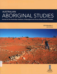
Periodical, Australian Institute of Aboriginal and Torres Strait Islander Studies, Australian Aboriginal studies : journal of the Australian Institute of Aboriginal and Torres Strait Islander Studies, 2010
Mediating conflict in the age of Native Title Peter Sutton (The University of Adelaide and South Australian Museum) Mediators have played roles in managing conflict in Aboriginal societies for a long time. This paper discusses some of the similarities and differences between older customary mediator roles and those of the modern Native Title process. Determinants of tribunal outcomes for Indigenous footballers Neil Brewer, Carla Welsh and Jenny Williams (School of Psychology, Flinders University) This paper reports on a study that examined whether football tribunal members? judgments concerning players? alleged misdemeanours on the sporting field are likely to be shaped by extra-evidential factors that disadvantage players from Indigenous backgrounds. Indigenous and non-Indigenous Australian Football League (AFL) players, matched in terms of their typical levels of confidence and demeanour in public situations, were interrogated in a mock tribunal hearing about a hypothetical incident on the football field. The specific aim was to determine if the pressures of such questioning elicited behavioural differences likely to be interpreted as indicative of testimonial unreliability. Mock tribunal members (number = 103) then made judgments about the degree to which a number of behavioural characteristics were evident in the players? testimonies. Under intense interrogation, Indigenous players were judged as presenting less confidently and displaying a greater degree of gaze aversion than non-Indigenous players. These behavioural characteristics are commonly ? and inappropriately ? used as cues or heuristics to infer testimonial accuracy. The paper discusses the implications for Indigenous players appearing at tribunal hearings ? and for the justice system more broadly. Timothy Korkanoon: A child artist at the Merri Creek Baptist Aboriginal School, Melbourne, Victoria, 1846?47 ? a new interpretation of his life and work Ian D Clark (School of Business, University of Ballarat) This paper is concerned with the Coranderrk Aboriginal artist Timothy Korkanoon. Research has uncovered more about his life before he settled at the Coranderrk station in 1863. Evidence is provided that five sketches acquired by George Augustus Robinson, the former Chief Protector of Aborigines, in November 1851 in Melbourne, and found in his papers in the State Library of New South Wales, may also be attributed to the work of the young Korkanoon when he was a student at the Merri Creek Baptist Aboriginal School from 1846 to 1847. Developing a database for Australian Indigenous kinship terminology: The AustKin project Laurent Dousset (CREDO, and CNRS, Ecole des Hautes Etudes en Sciences Sociales), Rachel Hendery (The Australian National University), Claire Bowern (Yale University), Harold Koch (The Australian National University) and Patrick McConvell (The Australian National University) In order to make Australian Indigenous kinship vocabulary from hundreds of sources comparable, searchable and accessible for research and community purposes, we have developed a database that collates these resources. The creation of such a database brings with it technical, theoretical and practical challenges, some of which also apply to other research projects that collect and compare large amounts of Australian language data, and some of which apply to any database project in the humanities or social sciences. Our project has sought to overcome these challenges by adopting a modular, object-oriented, incremental programming approach, by keeping metadata, data and analysis sharply distinguished, and through ongoing consultation between programmers, linguists and communities. In this paper we report on the challenges and solutions we have come across and the lessons that can be drawn from our experience for other social science database projects, particularly in Australia. A time for change? Indigenous heritage values and management practice in the Coorong and Lower Murray Lakes region, South Australia Lynley A Wallis (Aboriginal Environments Research Centre, The University of Queensland) and Alice C Gorman (Department of Archaeology, Flinders University) The Coorong and Lower Murray Lakes in South Australia have long been recognised under the Ramsar Convention for their natural heritage values. Less well known is the fact that this area also has high social and cultural values, encompassing the traditional lands and waters (ruwe) of the Ngarrindjeri Nation. This unique ecosystem is currently teetering on the verge of collapse, a situation arguably brought about by prolonged drought after decades of unsustainable management practices. While at the federal level there have been moves to better integrate typically disparate ?cultural? and ?natural? heritage management regimes ? thereby supporting Indigenous groups in their attempts to gain a greater voice in how their traditional country is managed ? the distance has not yet been bridged in the Coorong. Here, current management planning continues to emphasise natural heritage values, with limited practical integration of cultural values or Ngarrindjeri viewpoints. As the future of the Coorong and Lower Murray Lakes is being debated, we suggest decision makers would do well to look to the Ngarrindjeri for guidance on the integration of natural and cultural values in management regimes as a vital step towards securing the long-term ecological viability of this iconic part of Australia. Hearts and minds: Evolving understandings of chronic cardiovascular disease in Aboriginal and Torres Strait Islander populations Ernest Hunter (Queensland Health and James Cook University) Using the experience and reflections of a non-Indigenous clinician and researcher, Randolph Spargo, who has worked in remote Aboriginal Australia for more than 40 years, this paper tracks how those at the clinical coal-face thought and responded as cardiovascular and other chronic diseases emerged as new health concerns in the 1970s to become major contributors to the burden of excess ill health across Indigenous Australia. The paper cites research evidence that informed prevailing paradigms drawing primarily on work in which the clinician participated, which was undertaken in the remote Kimberley region in the north of Western Australia. Two reports, one relating to the Narcoonie quarry in the Strzelecki Desert and the other concerning problematic alcohol use in urban settings.maps, b&w photographs, colour photographs, tablesstrzelecki desert, native title, timothy korkanoon, merri creek baptist aboriginal school, austkin project, coorong, lower murray lakes district, south australia, indigenous health -
University of Melbourne, Burnley Campus Archives
Document, Report by the Working Party on the Use and Administration of College Lands, 1975
... Boulevard Richmond melbourne working party college lands agriculture ...Department of Agriculture, Victoria, 51 pp.working party, college lands, agriculture, victoria -
Lakes Entrance Historical Society
Book, A Study of Land in the Catchment of the Gippslnd Lakes Vol 1, 1988
... Department of Conservation Forests and Lands Victoria... Department of Conservation Forests and Lands Victoria ...108 printed pages in report, wire spiral boundBlue cardboard cover with title printed in golddocuments, reports -
 Whitehorse Historical Society Inc.
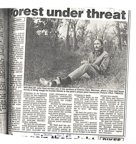
Article, Forest under threat, 13/09/1986 12:00:00 AM
... victoria. department of conservation forests and lands... robinson randall victoria. department of conservation forests ...An article in the Nunawading Gazette, naturalist John Reid has asked Council to commission a survey of flora and fauna of Antonio Park, Mitcham before this significant bushland remnant is impossible to save.native plants, antonio park, mitcham, reid, john, robinson, randall, victoria. department of conservation forests and lands -
 Whitehorse Historical Society Inc.
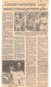
Article, Conservationists to urge weed management plan, 5/04/1989 12:00:00 AM
... Mitcham melbourne environment weeds victoria. department ...Article from Nunawading Gazette dated 5 April 1989 about a weed management plan in the City of Nunawading.environment, weeds, victoria. department of conservation, forests and lands., native plants, edwards, margaret, meagher, dorothy, witherspoon, cameron, david -
 Ballarat Tramway Museum
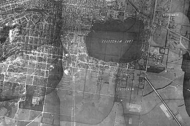
Photograph - Black & White Photograph/s, State of Victoria Lands Department, c1940
... State of Victoria Lands Department.... of Victoria Lands Department. ...Yields information about the development and Lake Wendouree from an aerial photograph c1940.Black and white photograph of an aerial view of the Lake Wendouree and the northern part of Ballarat c1940. Shows the photograph join lines, has names of suburbs, Railway lines. Purchased from rusty via Ebay 16/5/2019.trams, tramways, lake wendouree, ballarat, aerial views