Showing 4547 items matching "historical maps"
-
 Federation University Historical Collection
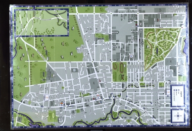
Map, Sebastopol (Delacombe, Redan and Ballarat South) Retail and Business Guide, 2005, 10/2005
Sebasgtopol is a suburb of Ballarat.Sebastopol, Delacombe, Redan and Ballarat South and business guide map.map, guide, delacombe, redan, ballarat south, victorian park, bray raceway, sebastopol equestrian centre, western oval, city oval -
 Federation University Historical Collection
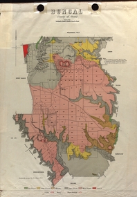
Map - Plan, E.J. Dunn, Bungal County of Grant Parish Plan
E.J. Dunn was the surveyor of this parish plan.Colour geological plan of Bungal in the County of Grant, Victoria. The areas circled in red ar craters.plan, bungal, bungeltap, black horse co. egerton, egerton, mount egerton, sister rose shaft, south learmonth co, kerrit bareet, bungaeeltap, yaloak, eastern moorabool river, corong, bungal station preemptive right, lal lal, western moorabool river, moorabool rover, borhoneychurck, mount egerton battery, bungal creek -
 Federation University Historical Collection
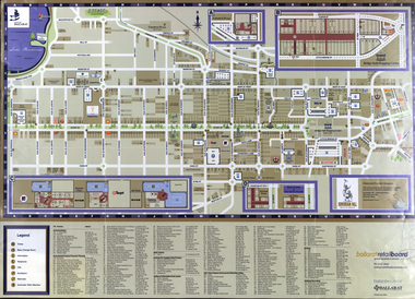
Map, Eastern Ballarat (c) Retail and Business Guide, 2004
Map of Ballarat East including Brown Hill, Mount Clear and Buninyong.brown hill, mount clear, mount helen, buninyong, university of ballarat -
 Federation University Historical Collection
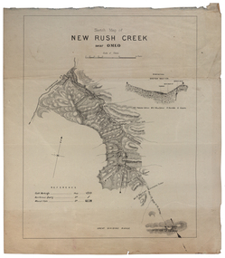
Plan, New Rush Creek near Omeo
new rush creek, omeo, map, livingstone creek -
 Federation University Historical Collection
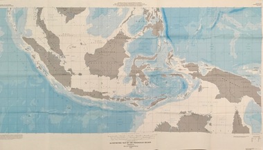
Map - Geological, U.S. Government Printing Office, Bathymetric Map of the Indonesian Region: Folio of the Indonesian Region Map I-875-A, 1974, 1974
Map was prepared on behalf of the Government of Indonesia, The United Nations Economic Commission for Asia and the Far East, the Agency for International Development and the U.S. Department of State in cooperation with the Geological Survey of Indonesia. The area covered shows the islands and seas from Latitude 12 degree North to 16 degrees South and Longitude 90 degrees to 148 degrees. Various water features are also named.Large map showing the Indonesian area - islands and seasLongitude and Latitude are shown. Major / Capitol cities indicated. Names of those responsible for the productionindonesia, united nations economic commission, department of state, geological survey, latitude, longitude, government of indonesia -
 Federation University Historical Collection
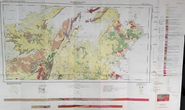
Map - Geological, Tallangatta, New South Wales: 1:250,000 Geological Series, SJ 55-3, 1966, 1966
Compiled by the Geological Survey of N.S.W., Division of Regional Geology. Topographical base compiled from Snowy Mountains Hydro Electrical Authority, Department of Lands, County maps and Snowy Lease Map. Other sheet adjoin this map. There are 13 formation sections grouped into 9 - Quaternary, Tertiary, Middle Devonian, Lower to Middle Devonian, Lower Devonian, Upper Silurian, Silurian, Upper Ordovician and Ordovician.Large coloured map showing geological features, faults, bores, rivers and mineral deposits.Scale of map, longitude and latitude, river names. "Tallangatta 1:250,00" written in black pen.tallangatta, new south wales, geological survey, topographical base, snowy mountains hydro electrical authority, department of lands, snowy lease map, department of mines, quaternary, tertiary, middle devonian, lower to middle devonian, lower devonian, uper siluran, silurian, upper ordovician, ordovician -
 Federation University Historical Collection
Map - Geological, Arnham Bay-Cove, Northern Territory: 1:250,000 Geological Series SD 53,4, 1968
-
 Federation University Historical Collection
Pamphlet, The Golden Plains Art Trail
Coloured pamphlet that folds out with a map of the locations on the Art Trailthe golden plains shire, helen lewers, dawn whitehead, edward coleridge-driver, ros lawson, arts trail -
 Federation University Historical Collection
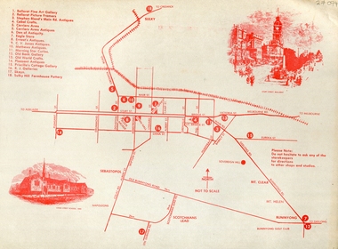
Document - Document - Tourist Guide, Jeff Zilles, ZILLES COLLECTION: Your Guide to Galleries Antique and Craft Shops in Ballarat, c1984
Zilles Printers was begun by Lewis Zilles in the early 1930s. It was in McKenzie Street Ballarat. His son Jeffrey also became a printer - letterpress, offset and screen printer. The business became Zilles Printers/Graphics and was in Armstrong Street and later Bell Street Ballarat. Tourist guide listing Galleries, Antique and Craft shops in Ballarat. Reverse side show map and locationsBuff coloured paper printing in red inkantiques, map, zilles, ballarat, gallaries, craft shops -
Federation University Historical Collection
Programme - Printed Programme, The School of Mines and Industries Ballarat Tour of Inspection
Four page programe for a Tour of Inspection of the Ballarat School of MInes. The tour included the Administration Builidng, E.J. Tippett Hall (former Wesleyan Church), Trade Workshops, Hickman Street, Army Huts (BCAE Art), Armstrong Street Vehicle Repair Trades, Electrical Trades. SMB Art, Battery (BCAE Pottery and Art), New Library Building (E.J. Barker Library. A map of the tour is given, and a development plan.ballarat school of mines, art, battery building, pottery, hickman st, trade workshops, e.j. tippett hall, map, plan -
 Federation University Historical Collection
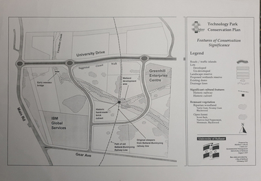
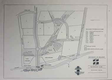
Map, Matthew Cibson, University of Ballarat Centre for Environmental Management, Ballarat Technology Park Conservation Plan, 1997, 02/1997
The Ballarat Technology Park is on the Federation University Mount Helen CampusMap showing the Ballarat Technlogy Camp, Greenhill Enterprise Centre, Canadian Wetlands. hand-made brick culvert sleepers, Ballarat-Buninyong Railway Line, IBM Global Services, early wooden bridge, Canadian Creek, Gear Avenue. ballarat technology park, canadian wetlands, greenhill enterprise centre, brick cultert, railway, ballarat-buninyong railway -
 Federation University Historical Collection
Plan - map, Ballarat Technology Park Wetlands Reserve and water retention basins, c1999
Yellow A4 page with a subdivision layout of the Ballarat Technology Park. It shows the Canadian Wetlands Researve and the water retentino.Detention Basins.canadian wetlands, ballarat technology park, mount helen campus -
Federation University Historical Collection
Book, Ballarat School of Mines Stock Register of Chemicals and Medications, 1887-1899
Joseph F. Usher was a lecturer at the Ballarat SChool of Mines from 1879-1891, and 1895-1909.A grey hard covred ledger with burgandy coloured spine and corners. Property of Dr Joseph Francis Usser M.D., L.A., H.D.. Contains 180 hand-numbered and lined pages.Zoological chart pasted inside front cover; geo-political maps of continents pasted into the back cover. Tables (some used by Usher) near the end of theis ledge book. Stocks are relevant to course at the Ballarat School of Mines.ballarat school of mines, register, j.f. usher, chemicals, medications, zoological chart, materia medica, staffmember -
 Federation University Historical Collection
Booklet - Annual Report, Greater Ballarat Association Annual Report 1952-1974, 1952-1974
The first presedent of the Greater Ballarat Association in 1938 was Robert J. Cooke. Eighteen annual reports of the Greater Ballarat Association. Each one discussed the work of the association and lists the subscribers. greater ballarat association, annual report, edgar bartrop, g.b. richmond, a.w. nicholson, g.e. deeble, r.g> caddell, l.j. fraser, t.u. haymes, a.w. lynch, keith rash, tourist bureau, botanical gardens telepone booth, pryor park tree planting, ballarat zoological gardens, centenary window dressing competition, soldier settlement, proposal for university for ballarat, caravan park, ballarat common, ballarat common development, t.t. hollway, housing commission, wendouree housing commission, industrial development, s.s. ballarat, begomia festiva, r.g. caddell, w.gordon smith, f.h. menzies, olympic rowing, royal tour decorations, begonia float, widening of railway bridge, j. chatham, l.g. chester, s.v. playsted, n. ellis, langi kal kal, langi kal kal training centre, migrants to victoria, flood lighting of the arch of victory, olympics holidays, ballarat's projected olympic pool, ballarat fish hatcheries, olympic hostel, town planning, murray byrne, titles for residence areas, service club signs, railway level crossing, traffic, ploughing competition, w. fraser, young australia league, removal of raaf from ballarat, renumbering of streets, renumbering of streets to the block system, miners' racecourse reserve, historical museum, ballarat historical society, c.m. canty, mavis canty, university status, ballarat university college, j.w. murray, p.r. gray, b.c. mcorist, n.c. ellis, w.h. heinz, save the lake campaign, lake wendouree, weed, home host scheme, b. walker, develop victoria council, eureka development, victorian decentralization league, r.h. ramsay, allan c. pittard, w. gordon smith, c.h. davis, b.c. hedgcock, les kennedy, p.j. rice, a.f. waddington, john p. cook, historic markers, maze, traffic lights, bungal dam, camera clubs, sunraysia way, map, centre of road parking, paddle steamer, wendouree apex, local government women's association, may nelson, wes sobey, melton foo, l.l. zilles, dulcie sullivan, m. barnes, lou zilles, john wesley sobey, e.r. ingles, herb warren, kryal castle -
 Bendigo Military Museum
Book, The Unit Historical Editorial Committee, White Over Green. The 2/4th Battalion & Reference to the 4th Battalion, 1963
Very light green hard cover, print is dark green ink. Image of 2/4th Battalion cover patch. 364 pages, illustrated with black & white photos, drawings & maps.Label: Rev A J & C E Kendallbooks, military history, biography -
 Bendigo Military Museum
Book - BOOK OF MILITIA UNITS, Historical Publications, Militia Units of Maryborough 1860-1901 (Victoria, Australia), 2017
Militia Units of Maryborough 1860-1901 (Victoria, Australia). Historical Publications. Included with book - Author's business card and leaflet titled "History of the/LEGION/of/FRONTIERSMEN/of the/COMMONWEALTH"Soft cover book. Soft cover - cardboard, black print on front and back, Illustration - front black and white photograph, half portrait of a soldier in uniform. Back - black and white small military coat of arms. 62 pages - cut, white, plain. Illustrated black and white photographs, maps and diagrams.books, military, history -
Federation University Historical Collection
Document, C.E. Hounam et al, Commonwealth of Australia Bureau of Meteorology - Climate of the Basaltic Plains of Western Victoria, 1963
Brown cardboard covered foolscap sized typed document with diagrams Handwritten on front. Symposium - Royal Society of Victoria "Basaltic Plains of Victoria" 12 September 1963basaltic plains of victoria, royal society of victoria, commonwealth of australia bureau of meteorology, c.e. hounam, f.a. powell, symposium, maps -
 Federation University Historical Collection
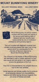
Card - Card - Advertising, ZILLES COLLECTION: Advertising Card promoting Mount Buninyong Winery
Zilles Printers was begun by Lewis Zilles in the early 1930s. It was in McKenzie Street Ballarat. His son Jeffrey also became a printer - letterpress, offset and screen printer. The business became Zilles Printers/Graphics and was in Armstrong Street and later Bell Street Ballarat. Mount Buninyong has become one of Victoria's prestigious wine growing areas due to the soil and the climate. Double-sided light beige card with black print. Map showing location.zilles printers, ballarat, mount buninyong, winery, -
Federation University Historical Collection
Book - Astronomy, Richard A. Proctor, Other Worlds Than Ours: The Plurality of Worlds Studied under the Light of Recent Scientific Researches, 1878
Richard Anthony Proctor (23 March 1837 – 12 September 1888) was an English astronomer who produced one of the earliest maps of Mars in 1867 from 27 drawings by the English observer William Rutter Dawes. He used old drawings of Mars dating back to 1666 to try to determine the sidereal day of Mars. His final estimate, in 1873, was 24h 37m 22.713s, very close to the modern value of 24h 37m 22.663s. Proctor was already a well-known populariser of science when he published this book, joining a ferocious debate about the possibility of life on other planets. The crater Proctor on Mars is named after him.Red hard covered book of 318 pages. Includes early images of planets as seen through a J. Browning Telescope. Proctor discusses Victorian discoveries about the solar system and describes what was then known about each of the planets. He evaluates the habitability of Mars, Jupiter, Mercury, Venus and Saturn in the light of his belief in the possibility of extraterrestrial life. The text includes many illustrations of the planets, a spectacular map of Mars, and theoretical views of the Milky Way. Influenced by Darwin, Proctor had a teleological view of the universe and believed that eventually the cosmos would be filled with living things. non-fictionRichard Anthony Proctor (23 March 1837 – 12 September 1888) was an English astronomer who produced one of the earliest maps of Mars in 1867 from 27 drawings by the English observer William Rutter Dawes. He used old drawings of Mars dating back to 1666 to try to determine the sidereal day of Mars. His final estimate, in 1873, was 24h 37m 22.713s, very close to the modern value of 24h 37m 22.663s. Proctor was already a well-known populariser of science when he published this book, joining a ferocious debate about the possibility of life on other planets. The crater Proctor on Mars is named after him.astronomy, planets, telescope, earth, sun, jupitar, saturn, uranus, neptune, moon, meteors, comets, solar system, nebulae, galaxies, milky way -
Federation University Historical Collection
Map, Aboriginal Language Areas in Victoria: A Reconstruction
A4 sized map of Victoria showing Aboriginal Langauge Areas. Black, white and red writing aboriginal, aboriginal language, victoria, djadja wurrung, woi wurrung, watha wurrung, gadubanud, girai wurrung, dhauwurd wurrung, djab wurrung, wiradjuri, tatungalung, wadiwadi, dadidadi, yuyu -
 Federation University Historical Collection
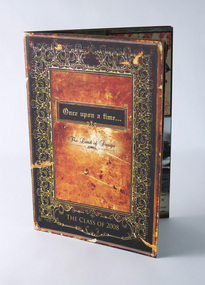
Booklet - Catalogue, Once upon a time… The Land of Design, Advanced Diploma of Arts (Graphic Design), 2008, 2008
Storybook/fairytale themed promotion of student work on completion of the two-year Advanced Diploma of Arts (Graphic Design) course at University of Ballarat, 2008. Page one features student names and photographs, plus "character" names. Pages 2-3 fairytale map. Subsequent pages include folio examples, one student per double page spread. Inside back cover notes sponsors, Sovereign Press and The Image Company. Teaching staff for duration of the two-year course listed as: James Baker, Peter Lambert, Jill Hyatt, Ben Sanders, Travis Price, Sam Harmer, Trevor Tagliabue, Alister Heighway, Sarah Lloyd. Promotional catalogue for graduating students of the University of Ballarat (TAFE), Advanced Diploma of Arts (Graphic Design). 32-page + 4-page cover saddle-stitched booklet. Full colour offset throughout.university of ballarat, federation university, graphic design, tafe, advanced diploma, arts academy, camp street campus -
 Marysville & District Historical Society
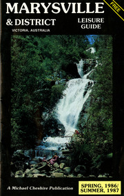
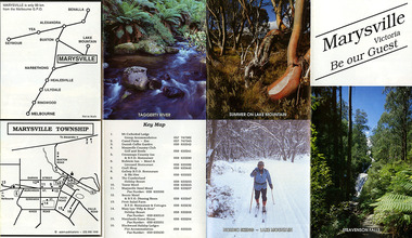
Booklet (Item) - Leisure guide, Michael Chesire & Associates Pty. Ltd, MARYSVILLE & DISTRICT LEISURE GUIDE-SPRING, 1986/SUMMBER, 1987, 1986
A free leisure guide to Marysville and the surrounding district published for Spring 1986, and Summer, 1987. This was produced by Michael Cheshire as a free publication to promote tourism in Marysville and the surrounding district. It includes maps of the Big River Valley, Cumberland Valley, Lady Talbot Forest Drive, the Marysville area, and the township of Marysville. It was released in the spring of 1986. A free leisure guide to Marysville and the surrounding district published for Spring 1986, and Summer 1987.Kilmore Historical Society *10/183 *MDL.1.marysville, victoria, australia, leisure guide, michael cheshire & associates pty ltd, marysville golf club, blackwood lodges, sir colin mackenzie fauna park, lake eildon, fraser national park, yarra valley wineries, marysville coach tours, kooringa, marylands guest house, lady talbot forest drive, wishing well, taggerty river recreation area, athols abbey, phantom falls, keppel falls, the beeches walking track, marylyn guest house, kufstein inn motel, the cumberland, marysville tourist & progress association, marysville newsagency & general store, crossways restaurant & motel, beauty spot walk, tree fern gully walk, michaeldene track, keppel track, woods lookout track, marysville hotel motel, lake mountain ski hire, marysville recreation and fun park, mytanta horseback safaris, upper big river valley, the big culvert, marysville mountain view horse hire, maryton park, amber view holiday lodges, cathedral restaurant, the top shop, tower motel, menzes garage, beauty spot nursery, marysville ski hire, lake mountain ski school, faraway forest, scenic motel, buxton trout farm, marysville hardware, timbertop steakhouse, marysville trout farm, healesville sanctuary, buxton hotel motel, nanda binya lodge, buxton antique and furniture mart, the black spur inn hotel, alexandra, lake mountain, j l gould sawmills pty. ltd., geoffrey pope & associates, marysville crafts & gifts, olde yarra track shoppe, cumberland scenic reserve, tudor lodge road house, fruit salad farm, highwayman's retreat -
 Marysville & District Historical Society
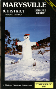
Booklet (Item) - Leisure guide, Michael Chesire & Associates Pty. Ltd, MARYSVILLE & DISTRICT LEISURE GUIDE-WINTER/SPRING 1987, 1987
A free leisure guide to Marysville and the surrounding district published for Winter and Spring, 1987. This was produced by Michael Cheshire as a free publication to promote tourism in Marysville and the surrounding district. It includes maps of the Big River Valley, Cumberland Valley, Lady Talbot Forest Drive, the Marysville area, and the township of Marysville. It was released in the winter of 1987. A free leisure guide to Marysville and the surrounding district published for Winter and Spring, 1987.marysville, victoria, australia, leisure guide, michael cheshire & associates pty ltd, marysville golf club, blackwood lodges, sir colin mackenzie fauna park, lake eildon, fraser national park, yarra valley wineries, marysville coach tours, kooringa, marylands guest house, lady talbot forest drive, wishing well, taggerty river recreation area, athols abbey, phantom falls, keppel falls, the beeches walking track, marylyn guest house, kufstein inn motel, the cumberland, marysville tourist & progress association, marysville newsagency & general store, crossways restaurant & motel, beauty spot walk, tree fern gully walk, michaeldene track, keppel track, woods lookout track, marysville hotel motel, lake mountain ski hire, marysville recreation and fun park, mytanta horseback safaris, upper big river valley, the big culvert, marysville mountain view horse hire, maryton park, amber view holiday lodges, cathedral restaurant, the top shop, tower motel, menzes garage, marysville ski hire, lake mountain ski school, faraway forest, scenic motel, buxton trout farm, marysville hardware, timbertop steakhouse, marysville trout farm, healesville sanctuary, buxton hotel motel, nanda binya lodge, buxton antique and furniture mart, the black spur inn hotel, alexandra, lake mountain, j l gould sawmills pty. ltd., geoffrey pope & associates, marysville crafts & gifts, olde yarra track shoppe, cumberland scenic reserve, tudor lodge road house, fruit salad farm, highwayman's retreat, beauty spot display gardens & nursery, ski lake mountain cross country ski hire & kitchen, buxton store, valley view marysville, acheron way, mt donna buang road, snow gum woodlands, alpine ash forests, mountain ash forests, stringybark forests, messmate forests, manna gum forests -
 Marysville & District Historical Society
Ephemera (Item) - Tourist Guide, Marysville Tourist Association, Marysville Victoria Be our Guest, Unknown
A fold out tourist guide to Marysville and the surrounding district. This map was produced by the Marysville Tourist Association.A fold out tourist guide to Marysville and the surrounding district.marysville, victoria, australia, tourist guide, steavenson falls, mt cathedral lodge, camelot camel farm, danish coffee garden, marysville country club, crossways country inn, kufstein inn, marysville craft shop, gallery restaurant, the cumberland, tower motel, marysville hotel, scenic motel, fruit salad farm, marylyn guest house, marylands guest house, blackwood lodges, taggerty river, lake mountain -
 Marysville & District Historical Society
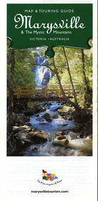
Map (Item) - Map and touring guide, Murrindindi Regional Tourism Association Inc, Marysville & The Mystic Mountains VICTORIA-AUSTRALIA, 08-2002
A fold out map and touring guide of Marysville and the surrounding district published in 2002 by Murrindindi Regional Tourism Association Inc.A fold out map and touring guide of Marysville and the surrounding district published in 2002 by Murrindindi Regional Tourism Association Inc.marysville, victoria, australia, map and touring guide, mystic mountains tourism, the beeches rainforest walk, lake mountain, cambarville, cathedral range state park, the cumberland, abbey green b&b cottages, anastasia fairytale cottage, ashlar cottage b&b, somerled mountain retreat, baree mudbrick cottages, blackwood cottages, camellia cottage, cathedral view b&b, cottage riverside, crossways country inn, dalrymples guest cottages, esa country ministries, hillcrest, keppels hotel motel, kerami house, lomatia lodge, lyell guest cottages, marylands country house, marysville caravan park, marysville holiday cottages, maryton park, melina cottage, moondai farm b&b, mountain lodge marysville, mount cathedral lodge, mystic mountains holiday cottages, nanda binya lodge, rendezvous on murchison, scenic b&b, the hermitage, tower motel, waratah house, willowbank at taggerty, woodlands of narbethong, keppels, lake mountain resort cafe, lanterns at willowbank, mantirri blueberry farm, marysville country bakery, the old woolshed cafe, clearstream olives, uncle fred & aunty val's old style lolly shop, acheron valley alpacas country store & gallery, bruno's art and sculpture garden, country touch, things of sand & stone, willowbank gallery, marysville auto & hardware, marysville newsagency & general store, marysville visitor information centre, narbethong visitor information centre, gallipoli park, keppels lookout, lady talbot drive, steavenson falls, steavenson river, taggerty river, acheron river, black spur trail riding centre, buxton trout farm, lake mountain resort ski hire, lake mountain ski school, marysville district country club, marysville ski centre, narbethong ski hire, rubicon horse riding, country touch tours, murrindindi regional tourism association inc -
 Marysville & District Historical Society
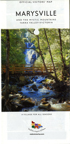
Map (Item) - Map and touring guide, Murrindindi Regional Tourism Association Inc, MARYSVILLE AND THE MYSTIC MOUNTAINS YARRA VALLEY-VICTORIA, Unknown
A fold out map and touring guide of Marysville and the surrounding district published by Murrindindi Regional Tourism Association Inc.A fold out map and touring guide of Marysville and the surrounding district published by Murrindindi Regional Tourism Association Inc.marysville, victoria, australia, map and touring guide, the cumberland, murrindindi regional tourism association inc, abbey green b&b, amberview lodge, anastasia fairytale cottage, ashlar cottage b&b, blackwood cottages, camellia log cabin, crossways country inn, dalrymples guest cottages, eagle mountain retreat, esa camping and conference centre, fruit salad farm, gilberts restaurant, keppels hotel motel, kerami house, kooringa resort and conference centre, lomatia lodge, lyelll guest cottages, marylands country house, marylyn holiday resort, marysville caravan park, marysville visitor information centre, alpacas at carmyle farm, australian adventure experience, bruno's art and sculpture garden, buxton trout farm, country touch tours, lake mountain, lake mountain ski hire, manical mechanicals, marysville district country club, marysville ski centre, rubicon valley horse riding, things of sand & stone, clearstream olives, the old woolshed cafe, fraga's cafe restaurant, lake mountain resort bistro, mantirri blueberry farm, gallipoli park, keppels lookout, cambarville, lady talbot drive, cathedral range state park, steavenson falls, steavenson river, taggerty river, acheron river, marysville auto and hardware, marysville newsagency & general store, narbethong visitor information centre, visit victoria -
 Marysville & District Historical Society
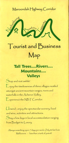
Map (Item) - Tourist and business map, Narbethong Community and Tourism Group, Narbethong Buxton Taggerty Tourist and Business Map, 04-2008
A tourist and business map of Narbethong, Buxton and Taggerty. This map was produced by the Narbethong Community and Tourism Group in April 2008. It was produced to promote the natural attractions, adventure activities and food trail from the Black Spur, through Narbethong, Buxton and Taggerty.A tourist and business map of Narbethong, Buxton and Taggerty.This publication has been produced by the Narbethong Community and Tourism/ Group (NCTG) to promote the natural attractions, adventure activities and food/ trail from the Black Spur, through Narbethong, Buxton and Taggerty./ the information provided in this publication has been supplied by the individual/ members. NCTG takes no responsibility for its accuracy./ April 2008narbethong, buxton, taggerty, victoria, australia, tourist and business map, narbethong community and tourism group, acheron valley, yarra track, wood's point, black spur, mystic mountains, the meeting of the waters, cathedral range, danico design counted cross stitch, things of sand & stone, buxton zoo nursery & oddz & enz, willowbank at taggerty, safe trek 4wd services, pnl 4wdriving, buxton trout and salmon farm, mystic mountains ski hire & outdoors, narbethong ski hire, highwood health centre, cathedral view natural therapies, narby cabinets, plants by shelian, gb timber, executive signs, rb automotive repairs, buxton car care, marysville towing & equipment hire, martyn slade building design, cathedral peak framing, black spur roadhouse & ski hire, tudor lodge roadhouse & ski hire, buxton roadhouse & persian bazzar, buxton post office general store & niche bar, igloo roadhouse, taggerty store, narby eggs, marapana agistment park, mantirri blueberry farm, carmyle farm, hazelwood hazelnuts, south cathedral lavender farm, cathedral cherries, black spur motel & caravan park, woodlands rainforest retreat, chestnut glade, black spur inn, wombat cottage, abbey lake luxury b & b spa cottages, blue views holiday cottages, camp narbethong, marapana farm stay b & b, mantirri blueberry farm b & b, little dene garden cottages, silverstream b & b cottages, nareen cabins, moondai farm b & b, south cathedral farm luxury b & b cottages, yarrolyn caravan park, sarsens rest, lomah retreat, pinjarra gardens, kingbilli country estate, henry viii manor house, buxton hotel, butters cafe of buxton, wagtail wines, little river wines, lanterns at willowbank, wirrawilla rainforest walk, wilhemina falls, the cascades -
 Marysville & District Historical Society
Map (Item) - Tourist and business map, Narbethong Community and Tourism Group, the Gateway TOURIST AND BUSINESS MAP, 08-2009
A tourist and business map of Narbethong, Buxton, and Taggerty. This map was produced by the Narbethong Community and Tourism Group Inc in August 2009. It was produced to promote the natural attractions, adventure activities, and food trail from the Black Spur, through Narbethong, Buxton, and Taggerty.A tourist and business map of Narbethong, Buxton and Taggerty.This publication has been produced by the Narbethong Community and Tourism Group Inc./ (NCTG) The information provided in this publication has been supplied by the individual/ members. NCTG takes no responsibility for its accuracy./ August 2009narbethong, buxton, taggerty, victoria, australia, tourist and business map, the gateway tourist and business map, black spur motel & caravan park, woodlands rainforest retreat, chestnut glade, black spur inn, wombat cottage, abbey lake luxury b&b spa cottages, camp narbethong, marapana farm stay b&b, mantirri b&b, little dene garden cottages, nareen cabins, silverstream b&b cottages, buxton hotel motel, south cathedral farm luxury b&b cottages, cathedral view b&b retreat, kingbilli country estate, cathedral valley farm, pinjarra gardens, willowbank at taggerty, sarsens rest, yarrolyn caravan park, danico design counted cross stitch, things of sand & stone, buxton zoo nursery, safetrek 4wd services, mystic mountains ski hire & outdoors, pnl 4wdriving, buxton trout and salmon farm, buxton bait and tackle, black spur roadhouse, tudor lodge service station roadhouse & ski hire, buxton roadhouse, buxton p.o. general store, igloo roadhouse, henry v111 manor house, buxton hotel, butters cafe, wagtail wines, little river wines, narby eggs, marapana agistment park, carmyle farm, hazelwood hazelnuts, cathedral view naturall therapies, cre8ing growth, linda hailey, naby cabinets, gb timber, narbethong timber & trading, rb automotive repairs, buxton car care, martyn slade building design, taggerty vet clinic