Showing 504 items
matching land owners
-
 Wodonga & District Historical Society Inc
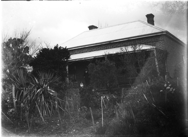
Negative - Haeusler Glass Negatives Collection - Man and a dog standing on a verandah, c1910
The Wodonga Historical Society Haeusler Collection provides invaluable insight into life in late nineteenth and early twentieth century north east Victoria. The collection comprises manuscripts, personal artefacts used by the Haeusler family on their farm in Wodonga, and a set of glass negatives which offer a unique visual snapshot of the domestic and social lives of the Haeusler family and local Wodonga community. The Haeusler family migrated from Prussia (Germany) to South Australia in the 1840s and 1850s, before purchasing 100 acres of Crown Land made available under the Victorian Lands Act 1862 (also known as ‘Duffy’s Land Act’) in 1866 in what is now Wodonga West. The Haeusler family were one of several German families to migrate from South Australia to Wodonga in the 1860s. This digital image was produced from one of the glass negatives that form part of the collection, probably taken by Louis Haeusler (b.1887) with the photographic equipment in the Wodonga Historical Society Haeusler Collection.This item is unique and has well documented provenance and a known owner. It forms part of a significant and representative historical collection which reflects the local history of Wodonga. It contributes to our understanding of domestic and family life in early twentieth century Wodonga, as well as providing interpretative capacity for themes including local history and social history.Digital image created from the Haeusler Glass negative collection. A man a dog standing on a verandah. The house is made of brick with a roof of corrugated iron.wodonga pioneers, haeusler family, glass negatives, dry plate photography, wodonga families -
 Wodonga & District Historical Society Inc
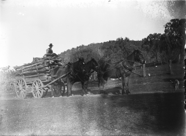
Negative - Haeusler Glass Negatives Collection - Man and horses carting timber, c1910
The Wodonga Historical Society Haeusler Collection provides invaluable insight into life in late nineteenth and early twentieth century north east Victoria. The collection comprises manuscripts, personal artefacts used by the Haeusler family on their farm in Wodonga, and a set of glass negatives which offer a unique visual snapshot of the domestic and social lives of the Haeusler family and local Wodonga community. The Haeusler family migrated from Prussia (Germany) to South Australia in the 1840s and 1850s, before purchasing 100 acres of Crown Land made available under the Victorian Lands Act 1862 (also known as ‘Duffy’s Land Act’) in 1866 in what is now Wodonga West. The Haeusler family were one of several German families to migrate from South Australia to Wodonga in the 1860s. This digital image was produced from one of the glass negatives that form part of the collection, probably taken by Louis Haeusler (b.1887) with the photographic equipment in the Wodonga Historical Society Haeusler Collection.This item is unique and has well documented provenance and a known owner. It forms part of a significant and representative historical collection which reflects the local history of Wodonga. It contributes to our understanding of domestic and family life in early twentieth century Wodonga, as well as providing interpretative capacity for themes including local history and social history.Digital image created from the Haeusler Glass negative collection. A man and 3 horses carting a load of timber. There is a dog on the far right of the image.wodonga pioneers, haeusler family, glass negatives, dry plate photography, wodonga families, timber carting -
 Wodonga & District Historical Society Inc
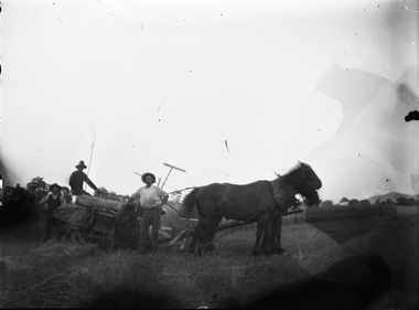
Negative - Haeusler Glass Negatives Collection - Men with horses in a paddock, c1910
The Wodonga Historical Society Haeusler Collection provides invaluable insight into life in late nineteenth and early twentieth century north east Victoria. The collection comprises manuscripts, personal artefacts used by the Haeusler family on their farm in Wodonga, and a set of glass negatives which offer a unique visual snapshot of the domestic and social lives of the Haeusler family and local Wodonga community. The Haeusler family migrated from Prussia (Germany) to South Australia in the 1840s and 1850s, before purchasing 100 acres of Crown Land made available under the Victorian Lands Act 1862 (also known as ‘Duffy’s Land Act’) in 1866 in what is now Wodonga West. The Haeusler family were one of several German families to migrate from South Australia to Wodonga in the 1860s. This digital image was produced from one of the glass negatives that form part of the collection, probably taken by Louis Haeusler (b.1887) with the photographic equipment in the Wodonga Historical Society Haeusler Collection.This item is unique and has well documented provenance and a known owner. It forms part of a significant and representative historical collection which reflects the local history of Wodonga. It contributes to our understanding of domestic and family life in early twentieth century Wodonga, as well as providing interpretative capacity for themes including local history and social history.Digital image created from the Haeusler Glass negative collection. 3 men with horses and farm machinery in a paddock.wodonga pioneers, haeusler family, glass negatives, dry plate photography, wodonga families, early farming -
 Wodonga & District Historical Society Inc
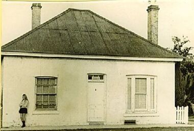
Photograph - Stonleigh, Wodonga
Stonleigh is one of Wodonga’s earliest buildings and stands on land granted to Daniel Rhodes in 1854, in one of the first land sales conducted in Wodonga. The building commenced soon after with the stone walls being 18 inches (46cm) thick. It was a four-room granite rubble stone building with central door and a window on either side, with a separate kitchen, as was typical of the worker's cottage of the day. The original roof would have been shingles but it was replaced with corrugated iron. It passed through several owners including Paul Huon in 1858. Peter Tenner, a farmer and vigneron took over in 1866 when it was described as “built of stone and having a cellar and a detached kitchen plus outside toilet, and a shed or two.” In the late 1880’s it was owned by William Smith who had come to Wodonga as a missionary for the Presbyterian Church and who, together with John Whan, storekeeper, was instrumental in building the Presbyterian Church nearby. Between 1890 and 1910 further buildings were added, consisting of double brick walls, two bedrooms, kitchen, laundry with brick and copper, bathroom and side verandah. William Smith established Wodonga Cordage Works in the Stonleigh buildings. The front room of the house was the display room for the business which manufactured and sold fishing lines, various types of cordage and water bags, the latter being of hand-sewn canvas. After 1954 Stonleigh became a bottle depot and bottle museum under ownership of Ramon Porta. At one stage he had over 50,000 bottles on display. In 1991 it was purchased by Mark Fraser, a cabinet maker, who made extensive renovations at the rear of the premises and internally, but left the façade untouched. Over recent times, Stonleigh was the home of several business including a florist, a patchwork maker and a café. Stonleigh was sold in 2021 and is now a private residence.These images capture one of Wodonga's oldest buildings.A series of photos, both colour and black and white, showing the building "Stonleigh' at different periodsstonleigh wodonga, old buildings wodonga, wodonga businesses, wodonga pioneers -
 Wodonga & District Historical Society Inc
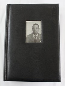
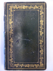
Album - Haeusler Family Photograph Album c. Mid Twentieth-Century
The Wodonga Historical Society Haeusler Collection provides invaluable insight into life in late nineteenth and early twentieth century north east Victoria. The collection comprises manuscripts, personal artefacts used by the Haeusler family on their farm in Wodonga, and a set of glass negatives which offer a unique visual snapshot of the domestic and social lives of the Haeusler family and local Wodonga community. The Haeusler family migrated from Prussia (Germany) to South Australia in the 1840s and 1850s, before purchasing 100 acres of Crown Land made available under the Victorian Lands Act 1862 (also known as ‘Duffy’s Land Act’) in 1866 in what is now Wodonga West. The Haeusler family were one of several German families to migrate from South Australia to Wodonga in the 1860s. This album contains portrait photographs of the Haeusler family in the mid-twentieth century, and images of the town of Wodonga. They were taken by Alf Haeusler (1922-1997). This item has well documented provenance and a known owner. It forms part of a significant and representative historical collection which reflects the local history of Wodonga. It contributes to our understanding of social and family life in early twentieth century Wodonga, as well as providing interpretative capacity for themes including local history and social history.A black leather photograph album containing family photographs from the early to mid twentieth-century.photograph, photographs, photography, family photos, album, photograph album, haeusler, haeusler collection, wodonga -
 Wodonga & District Historical Society Inc
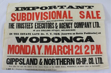
Poster - Hamilton-Smith Collection Wodonga Subdivision Poster
The Hamilton-Smith collection was donated by the children of Grace Mary Hamilton-Smith nee Ellwood (1911-2004) and John Hamilton-Smith (1909-1984) who settled in Wodonga in the 1940s. The Ellwood family had lived in north-east Victoria since the late 1800s. Grace’s mother, Rosina Ellwood nee Smale, was the first teacher at Baranduda in 1888, and a foundation member of the C.W.A. Rosina and her husband Mark retired to Wodonga in 1934. Grace and John married at St. David’s Church, Albury in 1941. John was a grazier, and actively involved in Agricultural Societies. The collection contains significant items which reflect the local history of Wodonga, including handmade needlework, books, photographs, a wedding dress, maps, and material relating to the world wars. This item has well documented provenance and a known owner. It forms part of a significant and representative historical collection which reflects the local history of Wodonga. It contributes to our understanding of social and family life in early twentieth century Wodonga, as well as providing interpretative capacity for themes including local history and social history. A white poster with black and red text advertising a subdivision sale sale, subdivision, wodonga, land, building, development, hamilton-smith, hamilton-smith collection -
 Wodonga & District Historical Society Inc
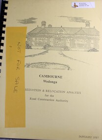
Booklet - Cambourne Wodonga : Conservation & Relocation Analysis for the Road Construction Authority, John & Thurley O'Conner, 1987
Research paper into the viability of relocating Cambourne Homestead in 2006 in order to make way for the widening and upgrade of the Hume Highway.non-fictionResearch paper into the viability of relocating Cambourne Homestead in 2006 in order to make way for the widening and upgrade of the Hume Highway. cambourne homestead wodonga, heritage building wodonga, carkeek family, potter family, building relocation -
 Linton and District Historical Society Inc
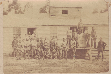
Photograph, 'Glenfine' Shearing Shed, 1890
In July 1840, Glenfine, consisting of 31,440 acres, was acquired by Thomas Downie. In March 1842 the 'Right of Run' was taken up by Thomas Chirnside who with an imported stallion 'Delapre' ran a horse stud. He apparently lived here for ten years and employed a gardener with a wife and five children from Hobart, Tasmania. Only some blocks of stone and a few trees remain of their homestead. In 1853 the property was transferred to Dr. John Chirnside, an elder brother of Thomas. I, 1857, William Rose of Naringal purchased Glenfiine where he and his family lived until 1904 when it was bought by Richard Howell's estate. It was then 39,000 acres. The present house was built by the Rowes in 1872 of bluestone quarried on the property with a cement render overall. The architect was H.R. Casselli. In 1911 R.C. Howell, son of Richard, became the owner, followed by his son in 1960. Gold was found on the property and by 1898 the township of Hollybush was first reported, situated at either side of the front entrance, on the Cressy Road. The land for the township was given by William Rowe. By 1990 Hollybush had a population of 426 persons. All of the early history of Glenfine, documents etc., were destroyed when Naringal homestead was burnt down in 1944. Glenfine was classified by the National Trust in 1974 and is on the Heritage Commission Register. Mounted black and white image of a large group of men and boys in front of a weatherboard shearing shed. The men are each holding a pair of hand shears. One young man is kneeling on top of a wool bale. A small blue biro 'x' identifies W. Todd. Glenfine was a pastoral station. The original homestead still stands.shearing sheds, shearers, rural activity, william todd, glenfine pastoral station, thomas chirnside, thomas downie, richard howell -
 City of Kingston
Photograph - Colour, Paul Tresize, 1998
The name Mordialloc was derived from the name Moody Yallock, which comes from the Bunurong language. The Bunurong Peoples are the Traditional Owners of this area. The name means “high water” or “high creek”. In 1839, colonial authorities declared the mouth of the creek, and an additional 830 odd acres as an Aboriginal Reserve, although this proclamation was never gazetted. The reserved land included part of the Carrum Carrum Swamp which was abundant with wild life and natural resources. Regular encroachments, including land sales which began in 1863, were made on the land until 1878 when the Reserve was declared closed, and the land was opened up to land sales. Market gardening and suburban house lots quickly began to develop, and Mordialloc became a renowned picnic and holiday site. Mordialloc Creek is a popular bay side destination for local and visitors, and is a site for boating, kayaking, fishing and swimming, along with many other activities.Colour photograph of Mordialloc Creek, looking out to the bay. Many small fishing and leisure craft are moored on either side of the banks of the creek. To the right hand side can be seen parklands, while the left hand side has a small inlet in which more small crafts are moored.mordialloc, bunurong, traditional owners, suburbs, boats, fishing, waterways -
 City of Kingston
Photograph - Colour, 1998
The name Mordialloc was derived from the name Moody Yallock, which comes from the Bunurong language. The Bunurong Peoples are the Traditional Owners of this area. The name means “high water” or “high creek”. In 1839, colonial authorities declared the mouth of the creek, and an additional 830 odd acres as an Aboriginal Reserve, although this proclamation was never gazetted. The reserved land included part of the Carrum Carrum Swamp which was abundant with wild life and natural resources. Regular encroachments, including land sales which began in 1863, were made on the land until 1878 when the Reserve was declared closed, and the land was opened up to land sales. Market gardening and suburban house lots quickly began to develop, and Mordialloc became a renowned picnic and holiday site. Mordialloc Creek is a popular bay side destination for local and visitors, and is a site for boating, kayaking, fishing and swimming, along with many other activities.Colour photograph of Mordialloc Creek, looking inland.Small fishing and leisure boats are moored on either side of creek, with a view of the Mordialloc Bridge Hotel in the background.mordialloc, bunurong, traditional owners, suburbs, boats, fishing, waterways, hotel -
 City of Kingston
Photograph - Colour, Paul Tresize, 1998
The name Mordialloc was derived from the name Moody Yallock, which comes from the Bunurong language. The Bunurong Peoples are the Traditional Owners of this area. The name means “high water” or “high creek”. In 1839, colonial authorities declared the mouth of the creek, and an additional 830 odd acres as an Aboriginal Reserve, although this proclamation was never gazetted. The reserved land included part of the Carrum Carrum Swamp which was abundant with wild life and natural resources. Regular encroachments, including land sales which began in 1863, were made on the land until 1878 when the Reserve was declared closed, and the land was opened up to land sales. Market gardening and suburban house lots quickly began to develop, and Mordialloc became a renowned picnic and holiday site. Mordialloc Creek is a popular bay side destination for local and visitors, and is a site for boating, kayaking, fishing and swimming, along with many other activities.Colour photograph of Mordialloc Creek, looking inland. Boats are moored on either side of the creek and the Bridge Hotel is visible in the background.mordialloc, bunurong, traditional owners, suburbs, boats, fishing, waterways, hotel -
 City of Kingston
Photograph - Colour, Paul Tresize, 1998
The name Mordialloc was derived from the name Moody Yallock, which comes from the Bunurong language. The Bunurong Peoples are the Traditional Owners of this area. The name means “high water” or “high creek”. In 1839, colonial authorities declared the mouth of the creek, and an additional 830 odd acres as an Aboriginal Reserve, although this proclamation was never gazetted. The reserved land included part of the Carrum Carrum Swamp which was abundant with wild life and natural resources. Regular encroachments, including land sales which began in 1863, were made on the land until 1878 when the Reserve was declared closed, and the land was opened up to land sales. Market gardening and suburban house lots quickly began to develop, and Mordialloc became a renowned picnic and holiday site. Mordialloc Creek is a popular bay side destination for local and visitors, and is a site for boating, kayaking, fishing and swimming, along with many other activities.Colour photograph of Mordialloc Creek with boats moored on both sides of the street and Pompei's boat yard visible on the right hand side of the creek., Main Street and St Brigid's Catholic Church are visible in backgroundmordialloc, bunurong, traditional owners, suburbs, boats, fishing, waterways, hotel, church -
City of Kingston
Photograph - Colour, Paul Tresize, 1998
The name Mordialloc was derived from the name Moody Yallock, which comes from the Bunurong language. The Bunurong Peoples are the Traditional Owners of this area. The name means “high water” or “high creek”. In 1839, colonial authorities declared the mouth of the creek, and an additional 830 odd acres as an Aboriginal Reserve, although this proclamation was never gazetted. The reserved land included part of the Carrum Carrum Swamp which was abundant with wild life and natural resources. Regular encroachments, including land sales which began in 1863, were made on the land until 1878 when the Reserve was declared closed, and the land was opened up to land sales. Market gardening and suburban house lots quickly began to develop, and Mordialloc became a renowned picnic and holiday site. Mordialloc Creek is a popular bay side destination for local and visitors, and is a site for boating, kayaking, fishing and swimming, along with many other activities.Colour photograph of Mordialloc Creek with boats moored on both sides of the street and Pompei's boat yard visible on the right hand side of the creek., Main Street and St Brigid's Catholic Church are visible in background.mordialloc, bunurong, traditional owners, boats, fishing -
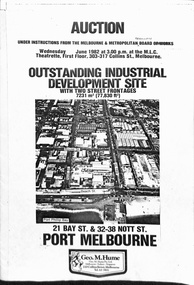 Melbourne Tram Museum
Pamphlet, Geo M Hume, "Auction - Outstanding Industrial development site - Port Melbourne", May. 1982
Draft of a pamphlet - folded A3 sheet for the sale in June 1982 of the former Port Melbourne Bus Depot, near the corner of Bay St and Beach St. Consists of two sheets of 150gsm ? paper bound together with an adhesive tape. A loose sheet showing the layout of the various titles included as well. Note the correction to the owners name from the MMBW to the MMTB. Includes an aerial photo of the site, photos of the buildings, addresses of the block, a site plan, title particular, terms of sale and the Vendors Agent, Geo M Hume.trams, tramways, mmtb, buses, sale of land, port melbourne depot -
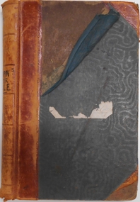
 Warrnambool and District Historical Society Inc.
Book, Thalaba the destroyer Vol 1, 1821
This book was written in 1801 in an epic poem form. It is unrhymed. It falls into the category of fantasy. The original owner of this book seems to have been John Bland. He is most important in the early history of Port Fairy and had a business in Port Fairy with John Cowtan (corn millers and general merchants). The Cowtans originally had land in the vicinity of the Cassady property of Boughton, Merri River (in Caramut Road near Cassady’s Bridge today) and were related by marriage to the Cassadys. A later owner of the book was William Anderson whose father came to the Yangery district in 1854 and established the property of Rosemount and William remained in this area until his death in 1909. The Andersons were related by marriage to the Cassadys and this book came to us following a clearance sale at the Cassady property, Boughton. This book is of great interest less for its literary content than for its ownership which probably dates back to the 1840s. It is associated with the families of Bland, Cowtan, Cassady and Anderson, all early settlers in Warrnambool and district.This is a brown leather-covered book of 271 pages. The cover has gold decorative borders and patterns and gold lettering. The pages are gilt-edged. The book is the fourth edition of volume one of a Robert Southey poem and has a Preface and Books 1 to 5 with Notes. The inscriptions are handwritten in black ink. One signature has not been deciphered. ‘Wm. Anderson’ ‘John Bland’ william anderson,, rosemount, william cassady, john bland, john cowtan, thalaba the destroyer, warrnambool, poem thalaba the destroyer, 19th century poems, robert southey books -
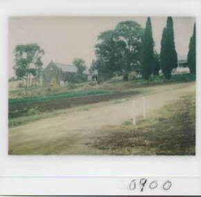 Sunbury Family History and Heritage Society Inc.
Photograph, Goonawarra Winery, c1970s
The property in the photograph is the winery building at Goonawarra Vineyard, which is situated on the east side of Jacksons Creek and on the north side of Macedon in Sunbury. The winery and homestead were established in 1858 by James Goodall Francis, who received a crown grant of land in Sunbury. From 1865 to the 1920s, the vineyard produced white wine grapes. James Goodall Francis died ion 1884 and the property was brought by M.P.Synott who ran merino sheep on the property. It wasn't until the early 1980s that Goonawarra reverted to be a vineyard after the property had been in the hands of a variety of owners. Goonawarra was one of Sunbury's earliest wineries to be established in the area.A coloured polaroid photograph with a white border, of a pathway leading to a double storey buildinggoonawarra winery, james goodall francis, wineries, jacksons creek -
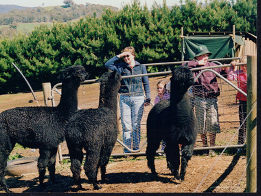
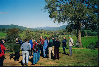 Wooragee Landcare Group
Photograph, 5 September 2004
This photograph was taken at Samaria Farm on Sunday the 5th of September as part of a day trip by the Wooragee Landcare Group. The event was about looking at land use on small farms and as a social get-together for the Group. Wooragee Landcare was also researching how small landholders could run some enterprises around the time of this trip. Samaria Farm is located in northeast Victoria, near Mount Samaria, which is located 130 km northeast of Melbourne. Samaria Farm was owned by Sue and Due Matheson at the time of the trip and had a renowned rose garden, pigs, poultry, alpacas, and goats on their nine-hectare farm. The rose garden consists of 3000 damask roses. Samaria Farm distils the oil from these roses and is the only farm in Australia to do this. Rose oil has historically been used for religious and medical use. 20 kg of rose buds are picked by hand every day, which is then distilled and produced 5 to 8 ml of oil. The entire four-week season produces 80 to 100 ml of oil. Rose water is also created during this process and produces about 300 litres per season. Along with the oil, the Farm also harvests lemons, lime, olives, and oranges. The Farm is currently owned by Utako and Anthony since 2022, with Vicki and Allan Wight being the previous owners. Wooragee Landcare Group was created in 1988. Its core mission is to work towards eradicating animals and pests from the land to protect the natural vegetation and promote revegetation projects. This photograph is a great example of the type of events that Wooragee Landcare Group has organized, while educating the public about the importance of land use management. The group is important to the community and for the environment.Landscape coloured photograph printed on gloss paperReverse: WAN NA E0NA2N2. NNN+ 2 4240/ [PRINTED] (No. 18) / 371samaria farm, wooragee, wooragee landcare group, wooragee landcare's collection, samaria, small farm, land use, social, rose oil, damask roses, pests -
 Wooragee Landcare Group
Photograph, 5 September 2004
This photograph was taken at Samaria Farm on Sunday the 5th of September as part of a day trip by the Wooragee Landcare Group. The event was about looking at land use on small farms and as a social get-together for the Group. Wooragee Landcare was also researching how small landholders could run some enterprises around the time of this trip. Samaria Farm is located in northeast Victoria, near Mount Samaria, which is located 130 km northeast of Melbourne. Samaria Farm was owned by Sue and Due Matheson at the time of the trip and had a renowned rose garden, pigs, poultry, alpacas, and goats on their nine-hectare farm. The rose garden consists of 3000 damask roses. Samaria Farm distils the oil from these roses and is the only farm in Australia to do this. Rose oil has historically been used for religious and medical use. 20 kg of rose buds are picked by hand every day, which is then distilled and produced 5 to 8 ml of oil. The entire four-week season produces 80 to 100 ml of oil. Rose water is also created during this process and produces about 300 litres per season. Along with the oil, the Farm also harvests lemons, lime, olives, and oranges. The Farm is currently owned by Utako and Anthony since 2022, with Vicki and Allan Wight being the previous owners. Wooragee Landcare Group was created in 1988. Its core mission is to work towards eradicating animals and pests from the land to protect the natural vegetation and promote revegetation projects. This photograph is a great example of the type of events that Wooragee Landcare Group has organized, while educating the public about the importance of land use management. The group is important to the community and for the environment. Landscape colored photograph printed on gloss paperReverse: WAN NA E0NA2N2. ANN+ 1 4240/ [PRINTED] (No. 19) / 372samaria farm, wooragee landcare group, wooragee, victoria, mount samaria, farming, roses, rose oil, damask roses, agriculture, pests, vegetation -
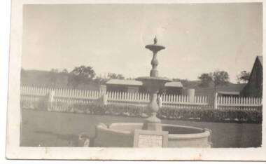 Sunbury Family History and Heritage Society Inc.
Photograph, Emu Bottom
The fountain in the image is at the entrance to the 'Emu Bottom' homestead. George Evans squatted on land to graze sheep, along the Jacksons Creek Valley, originally known as Buttlejork Valley, in 1836 and built the homestead from local Silurian sandstone and timber. Over the years it has had a number of owners. In the 1920s the property was renamed 'Holly Green' by H.L Webb after a property in Narre Warren.In the 1950s it was renamed 'Emu Bottom'. Over the years a number of fires have destroyed parts of the building and as a result, little of the original building remains. The fountain was erected in 1936 to mark the centenary of the property as well as 100 years of European settlement in theSunbury area. The property is now a private residence and function centre.'Emu Bottom' is one of the oldest homesteads in Victoria.A small non-digital sepia photograph with a cream border of a fountain, with a horse trough around the base, at the entrance of a rural property.'emu bottom', holly green, sunbury, jacksons creek, buttlejork valley, george evans -
 Flagstaff Hill Maritime Museum and Village
Map - Survey Map, F.F. McGovern, Yangery - County of Villiers, 1884
... HIll for Public Recreation. The map names the owners... names the owners of the land at that time. Hand written pencil ...A surveyor was employed to measure the land designated as Yangery, County of Villiers, in the Borough of Warrnambool. The area on the map is similar to the earlier Farnham Survey undertaken by William Rutledge in the 1850's. Warrnambool was a Borough between 1863-1883. Coutours, waterways, sea and other significant points are shown. The distances are accurately measured. This survey map was used for planning future land sales, recreation areas and roads. WILLIAM RUTLEDGE (1806-1876) William Rutledge surveyed the land known as Farnham in southwest Victoria in 1843. His tenants made him a profitable business from working the land there. In 1863 Rutledge moved from nearby Port Fairy to Farnham and became very successful in breeding sheep, which he imported from J.R. Kirkham of Lincolnshire, England. He also bred horses on his land. The survey map of Yangery is important for its connection with renowned surveyor William Rutledge. The map shows the growth of landholders in the district when compared to the original Rutledge survey of the 1850's.Survey map of Yangery, titled "Yangery - County of Villiers". Printed on white paper, mounted on brown paper. c. 1863-1876. Comments printed on the Map include; Special Survey by William Rutledge, Photo-lithographed at the Department of Lands and Survey, Melbourne by W.J. Burson, Price 1/- [one shilling]. Scale is in Chains. Map has boundaries of Koroit Borough, Meerai, Purnim, Wangoom, Borough of Warrnambool, Mentions the Proposal of Tower HIll for Public Recreation. The map names the owners of the land at that time. Hand written pencil marks and figures and "Sauls fence" drawn on map. Hand written pencil markes and figures and "Sauls fence" drawn onto map. "For Department Use only". "Scale: 8 chains to 1 inch" flagstaff hill, warrnambool, shipwrecked-coast, flagstaff-hill, flagstaff-hill-maritime-museum, maritime-museum, shipwreck-coast, flagstaff-hill-maritime-village, county of villiers map, yangery district, w.j. burson, borough of warrnambool, koroit, purnim, meerai, wangoom, proposal of tower hill for public recreation, special survey by william rutledge, william rutledge, farnham, lincolnshire sheep, clydesdale -
 Ringwood and District Historical Society
Document - Department of Lands and Survey, Wire Netting Branch, Melbourne, Victoria, Application for Vermin-Proof Fence Certificate - L.J. Mills vs John Collins, Grandview Grove, Ringwood, Victoria - 1939
Photocopied file of corresponence and documentation relating to a claim by L.J. Mills, Nurseryman, that adjoining property owner, J. Collins, Farmer, assists with replacement of a vermin proof wire netting dividing fence destroyed by 1939 bushfire. File includes 1939 and 1940 detailed property inspection reports by Vermin and Noxious Weeds Branch, Lands Department, Lilydale, describing land use in the area and signs of vermin activity. Application approved 18th April, 1940. Appeal lodged by Mr Collins disallowed in May, 1940. File closed June, 1940 with Departmental suggesion that Mr Mills consider further legal action through a Solicitor as fence had still not been wire-netted. TRANSCRIPTS: Vermin & Noxious Weeds Inspection Reports "19/9/1939 (To) Superintendent (Department of Lands and Survey, Melbourne) Re L.J. Mills application for Vermin Proof Fence. I called on Mr Mills yesterday 18th instant in connection with this matter. Mr Mills has a flower farm and claims that rabbits and hares are damaging his flowers. He showed me a bed of carnations which he stated were being damaged by rabbits. There was evidence of some leaves being nipped off, but I am unable to say whether this is due to rabbits or grubs. Very little if any real damage is being done. The property is netted on the east and south boundary and on half the north and west boundary. The surrounding country is undlating and fairly steep in places. The land to the east across Grandview Avenue (sic) is all planted out in old established orchards and well cultivated. Cleared grass land adjoins the south boundary and bush land adjoins the north and west boundaries. I walked over a large area surrounding Mr Mills land and never saw any rabbits or hares or any indications of rabbits. This locality is not rabbit infested and very little wire netting is being used. I do not consider that a vermin proof fence is necessary between these allotments. - Jas H Allison (Inspector, Vermin and Noxious Weeds Branch, Lands Department, Lilydale)." Follow up report following renewal of application for Certificate by Mr Mills, citing rabbits causing considerable damage to his flowers. He laid poison and obtained 9 carcases and stated that there is evidence of rabbit infestation from the adjoing land. "19/3/1940 (To) Mr Hannah (Superintendant, Department of Lands and Survey, Melbourne) Re L.J. Mills, Grandview Grove Ringwood, Lot 4 Grandview Estate Pt CG20 Ph of Warrandyte. I interviewed Mr Mills at his home on 15th inst. He showed me carcases of rabbits which he stated had been poisoned on his land. In places young plants had been nipped off apparently by rabbits. I made an inspection of adjoining properties and found one live burrow close to Mr Mills northern boundary. There were scratches and other evidence of rabbits on land north and west of Mr Mills property. In view of the present evidence of rabbits I consider that a vermin proof fence is now necessary to protect the flowers grown by Mr Mills. His land is netted on whole of east and south boundary and half way on west and north boundary. The adjoining land on west and north boundaries is owned by Mrs Linda Collins and John Collins resp of Brysons Road East Ringwood. - Jas H Allison (Inspector, Vermin and Noxious Weeds Branch, Lands Department, Lilydale)." -
 Bendigo Historical Society Inc.
Administrative record - LANDS OFFICE: APPLICATIONS FOR ALLOTMENTS FOR SALE 1869 - 1877, 1869 - 1877
Ledger. Hard cover journal, green cover with dark red spine and corners. Approx. 500 pages. LH page: date, parish, sec. allot. Area, applicant, address, valuation. RH page: owner of improvements, any other improvement on lot, upset price, remarks. On spine - 'applications for allotments for sale' and 'appn's for sale'.Lands Officeplace, land sales, bendigo, sandhurst -
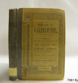 Flagstaff Hill Maritime Museum and Village
Book - Historical, Richard Osburne, The History of Warrnambool, 1887
This little book is one of only 1000 books published of the original Queen's Jubilee Edition. It spans fifty years of the history of Warrnambool from the time that the first Government Land Sales commenced. It also deliberately coincides with the 1887 celebrations of Queen Victoria's Jubilee Year of her ascension to the British Throne. The book is an invaluable reference for researchers of local Warrnambool history and has been used as a text book and reference book for local students. The book had two owners before it became part of the Warrnambool Public Library, and when the library closed down, the book was held by the Warrnambool City Council until, in 1974, it was transferred to the newly established Flagstaff Hill Maritime Museum and Village. The author, Richard Osburne, (1825-1895) was born in Australia. He moved to Warrnambool in 1847 as the first local Journalist. In 1851 he founded the Warrnambool Examiner newspaper which he operated until the end of 1880. Osburne was much involved in civic and community affairs of the town, and he set himself the task of recording the history of the city's early pioneers. In the introductory pages of the book the author refers to himself as "The Father of the Warrnambool Press". Only 1,000 copies of this edition of the book were printed. In September 1980 a facsimile edition was printed with the addition of illustrations from the period, an index and relevant annotations by local historian T.A. Wicking (Tom Wicking). This later book was named the Premier Town Edition, due to Warrnambool being awarded the title of Premier Town in Victoria in 1979-82 by the Premier of Victoria; it also received the inaugural award in 1959 and a later award in 1988-91. This book is rare. It is one of only 1000 copies printed, and one of three in the Collection of Flagstaff Hill Maritime Museum and Village. The book was dedicated to the early colonists as well as to the new arrivals by the writer, Richard Osburne, who entitles himself as "The father of the Warrnambool Press". The content of the book is invaluable as a reference for Warrnambool and District's local history in its early colonial and pioneering days. It provides the information that helps in an understanding the foundation that the city was built on, connecting the people of today to the pioneers of the past. The inscriptions of two previous owners of the book, at least one of whom was a local resident, gives additional significance to this copy. The History of Warrnambool: Capital of the Western Ports of Victoria From1847 (when the first Government Land Sales took place) up to the end of 1886, By Richard Osburne, Proprietor of the Warrnambool Examiner from 1851 to the close of 1880. Author: Richard Osburne Publisher: Prahran: The Chronicle Printing & Publishing Company Limited Date: 1887 (MDCCCLXXXVII) Edition: Original: Queen's Jubilee Edition Small book with hard cover and reinforced spine. Dust jacket front has been pasted over front hard cover. The hardcovers are covered with clear adhesive plastic covering. Inscriptions include a typed label on the spine, a stamp at base of the fly page, on the loose page inside front cover, on inside back cover, and two hand written names on the second fly page; Jackson Giblett and G. M. Potter. The first fly page has a message to the readers, as shown in the Inscriptions of this record.Label on spine "R.A. 994.57 OSB" Inscriptions on second fly page: "Jackson Giblett / 1886" and "G.M. Potter, 70 Japan Street" Printed on fly page: "PRICE, FIVE SHILLINGS" Stamp of front end paper: WARRNAMBOOL / PUBLIC LIBRARY", "000336" and in a rectangular border " - - - - - - / WARRNAMBOOL / PUBLIC LIBRARY" First fly page: "THE QUEEN'S JUBILEE EDITION. TO OLD COLONISTS AND YOUNG AUSTRALIANS, OR NEW ARRIVALS, THIS HISTORY OF THE RISE AND PROGRESS OF THE CAPITAL OF WESTERN VICTORIA, IS DEDICATED AS INTERESTING AND USEFUL, BY "THE FATHER OF THE WARRNAMBOOL PRESS" RICHARD OSBURNE." Stamp inside back cover: "WARRNAMBOOL LIBRARY/ Liebig Street / Warrnambool 3280 / (055) 6- 2258"warrnambool, shipwreck coast, flagstaff hill, maritime museum, maritime village, the history of warrnambool, richard osburne, osturne's history of warrnambool, queen's jubilee edition, 1847-1887, warrnambool history, the chronicle printing and publishing company, capital of the western ports of victoria, first government land sales, warrnambool examiner, five shillings, warrnambool's first reporter, warrnambool public library, 1887, 1979, premier town, premier edition, queen's jubliee, queen victoria's jubilee, western ports of victoria, 1847, government land sales, chronicle publishing and printing co., g m potter, 1000 copies, t a wicking, jackson giblett, 1886, japan street, old colonists, young australians, new arrivals, rise and progress, capital of western victoria, interesting and useful, the father of the warrnambool press -
Bendigo Historical Society Inc.
Document - REGISTRATION OF RESIDENCE AREAS 9433 - 13296: 1899 - 1905, 1899 - 1905
Document: hard cover journal, originally dark cover with burgundy binding on spine. In very poor condition, pages loose. Details: left hand page: date of registration, holder or owner, miners right etc., description of allotment, township or parish, memo, registration. Right hand page: same. Details land registrations in Bendigo and district.place, bendigo, land sales, bendigo, sandhurst, land sales, residence licences