Showing 726 items
matching land records
-
 Bayside Gallery - Bayside City Council Art & Heritage Collection
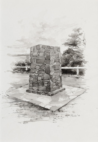
Work on paper - ink and watercolour, Annette Meikle, Moysey Memorial, 1977
In 1977, artist Annette Meikle undertook a commission to illustrate a book recording stories of places and people in the Bayside area. It was published in 1978 as Sandringham Sketchbook, with text by Elizabeth Waters. The sketches were intended to record remaining examples of Bayside’s early architecture and environment, as well as reflect newer architectural changes. Meikle went on to donate 22 of these sketches to Bayside City Council in 2003. Erected in 1964, this stone cairn on Beach Road in Beaumaris marks the site of the wattle and daub cottage of James and Susannah Moysey. James, Susannah and their cousin Nicholas arrived in Victoria in 1844 and leased land on the cliff-top. They built a cottage, cleared the land for sheep and cattle and established vegetable gardens. They later purchased the land and named it Beaumaris Park, derived from the name of the Welsh coastal resort where Edward I built Beau Marais castle.Annette Meikle, Moysey Memorial 1977, ink and watercolour, 35 x 23.5 cm. Bayside City Council Art and Heritage Collection. Donated by the artist, 2003annette meikle, sandringham sketchbook, elizabeth waters, port phillip bay, moysey memorial, coastline, stone cairn, james and susannah moysey, beaumaris -
 Bayside Gallery - Bayside City Council Art & Heritage Collection
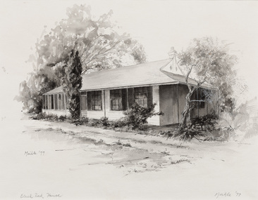
Work on paper - ink and watercolour, Annette Meikle, Black Rock House, 1977
In 1977, artist Annette Meikle undertook a commission to illustrate a book recording stories of places and people in the Bayside area. It was published in 1978 as Sandringham Sketchbook, with text by Elizabeth Waters. The sketches were intended to record remaining examples of Bayside’s early architecture and environment, as well as reflect newer architectural changes. Meikle went on to donate 22 of these sketches to Bayside City Council in 2003. Black Rock House was built in 1858 by wealthy land dealer and politician Charles Hobson Ebden as a holiday home on 112 acres of virgin scrub, taking in the area of present day Balcombe Road, Beach Road and the line of Keating Street. The house included four bedrooms, a cellar, stables and a courtyard enclosed in castle-like sandstone walls. It was named Black Rock House after Black Rock Castle near Dublin, associated with Mrs Ebden’s childhood.Annette Meikle, Black Rock House 1977, ink and watercolour, 33 x 53.5 cm. Bayside City Council Art and Heritage Collection. Donated by the artist, 2003annette meikle, sandringham sketchbook, elizabeth waters, black rock house, black rock, charles hobson ebden, architecture, historic house -
 Bayside Gallery - Bayside City Council Art & Heritage Collection
Map, H.B. Foot, Plan of the Brighton Estate containing 5120 acres, first special survey at Port Phillip, c. 1842
This plan records the Brighton Estate, also known as Dendy's Special Survey. In 1840 Henry Dendy, a farmer in Surrey, England acquired a "Special Survey" from the Commissioners for Land and Emigration which gave him the right to choose land in Port Phillip for the low price of £1 per acre for 5120 acres. Dendy appointed Jonathan Binns Were, as his agent, who later became a partner. Together, Dendy and Were decided on an area 5 miles south from Melbourne, bounded by North Road, East Boundary Road, South Road and to the west by Port Phillip Bay. Their Brighton Estate was first surveyed by T. S. Townsend in May 1841 and was re-surveyed by Robert Hoddle. Dendy and Were were making plans to sell the land and advertised a 30-guinea prize for the best subdivision which was to be divided into a village, marine residences, suburban and cultivation allotments, with the remainder being divided into country sections. The competition was won by H.B. Foot, who planned the village around a reserve and crescents and a 'green belt' forming the town boundary. brighton estate, dendy's special survey, special survey, henry dendy, jonathan binns were, w.b. were, survey, plan, map, brighton, george ward cole, baker's lithographer, hibernian, subdivision, town planning, cartographic material, h.b. foot -
 Bendigo Historical Society Inc.
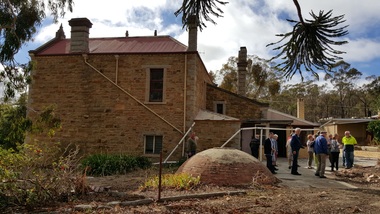
Photograph - Rocky Vale Villa, April 2016
The Beebe name was well-known in Bendigo in the last quarter of the 19th and the early part of the 20th centuries. From 1875, William Beebe senior, monumental mason, occupied a site in the centre on the city, in Mitchell Street opposite King Street. Death was more part of life in those days, and the Beebes were there to provide the burial monuments. Later, he took his sons into the business, which grew as Beebe and Son. Many examples of their work can be found in the local cemeteries. William Beebe senior (1830-1891) was born in Rutland, the smallest English county in 1830, to stonemason Chamberlain Beebe and Susannah Clements. William emigrated to Victoria in 1854 and after engaging on unknown works in Port Fairy, Dunkeld, and Melbourne arrived in Bendigo. His obituary records that he commenced work here on the site of the Bank of Australasia (opposite the Shamrock Hotel), which would have been no later than 1856. He took up a 13 acre selection on the site of Rocky Vale Villa in 1864 and continued to select or purchase further parcels of adjoining land until he owned some 150 acres, much of it unfit for cultivation. He was a keen gardener and had a garden and orchard around the house. William took over 20 years to build the two-story sandstone and granite house "Rocky Vale Villa". The house was constructed from sandstone sourced "from an adjacent ridge of rocks" (Bendigo Advertiser 28/9/1891). Granite from Harcourt was used for lintels and quoins. Not long before he died, William was still adding to the house. In the Codicil to his will, he states that "I have just built and completed two additional rooms to my Dwelling house situe at Inglewood Road aforesaid" (dated 19/9/1891). William died one week later on the 26th September 1891.Photographs of a field trip to Rocky Vale Villa, 7 Wicks Road, Maiden Gully, Bendigo by the Bendigo Historical Society.history, bendigo, rocky vale villa maiden gully, william beebe stonemason bendigo -
 Bendigo Historical Society Inc.
Financial record - Axedale Waterworks Trust
Collection of documents pertaining to the Axedale Waterworks Trust. The documents range in date from 1963 to 1968 and covers: Audit reports, Chairman letters to shareholders, financial statements, land reports. Aileen and John Ellison Collection.axedale water trust, financial record -
 Bendigo Historical Society Inc.
Administrative record - Land Leases
... ). Administrative record Land Leases ...Set of handwritten land leases book compiled by Ralph Birrell. Book 1: Leases from 1 to 313, year 1859. Book 2: 314/629, year 1860. Book 3: 630/945, year 1865. Book 4: 946/1261, year 1866. Book 5: 1262/1575, year 1869. Book 6: 1576/1720, year 1870. Book 7: 1901/2185, year 1871. Book 8: 2186/2500, year 1871. Book 9: 2501/2800, year 1872. Book 10: 2900/3214, year 1871. Book 11: 3215/3528, year 1873. Book 12: 3529/3848, year 1875. Book 13: 3849/4167, year 1877. Book 14: 4168/4157, year 1881. Book 15: 4518/4838, year 1881. Book 16: 4839/5155, year 1883. Book A: 1/450, years 1862-1863 (small white book). Book 1: 1863/3406, years 1868-1871, (small brown book). Book 2: 3407/5075, years 1871-1873 (small purple book). land leases, 1859/1883 -
 Bendigo Historical Society Inc.
Administrative record - Land Leases 1886 - 1899
... /7390, year 1899. Administrative record Land Leases 1886 - 1899 ...Dr Ralph Birrell (20/3/1927 - 7/6/2014) was a lecturer at the Bendigo School of mines and the author of numerous books about mining in Victoria, particularly Bendigo, and books on various elements of Bendigo history.Set of handwritten land leases books compiled by Ralph Birrell. Book 17: 5156/5573, year 1886. Book 18: 5574/5891. year 1887. Book 19: 5892/6211, year 1890. Book 20: 6212/6531, year 1893. Book 21: 6532/6849, year 1896. Book 22: 6849/71765, year 1897. Book 23: 7166/7390, year 1899.land leases, 1886-1899 -
 Bendigo Historical Society Inc.
Administrative record - Right to Occupy Certificates
Ten books containing stubs of Right to Occupy Certificates for 1936. Includes name and address of person receiving the Right to Occupy certificate and the description of the land including allotment, Section, City, Town, Borough or Township and Parish name. Two blue covered books used for Substitute Right to occupy certificates. One book, stubs only, dated 1976 - 1981. One with four stubs dated 1981 - 1983. Four stapled bundles of stubs dated 1937 - 1971 issued for Replacement Rights. Includes names and Receipt numbers. Yellow foolscap sheet Listing reord numbers of Rights issued during 1936 and 1937.Some items have pencil and pen marks and ink stains.right to occupy, central victoria -
 Bendigo Historical Society Inc.
Administrative record - Right to Occupy Certificates, 1936
Twelve books containing stubs of Right to Occupy Certificates for 1936. Includes name and address of person receiving the Right to Occupy certificate and the description of the land including allotment, Section, City, Town, Borough or Township and Parish name. List of record Numbers in Box 906 Some items have pencil and pen marks and ink stains.right to occupy, central victoria -
 Buninyong & District Historical Society
Photograph - B/W photograph, Mr. Clive J. Brooks, North Eastern slopes of Mount Buninyong from Yendon Road, April 1994
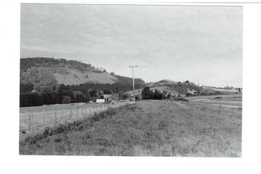
Tree cover on Mount Buninyong and agricultural use of land in 1994 clearly visible.Natural and agricultural record of Mount Buninyong in late 20th centuryBlack and white photograph of the North Eastern slopes of Mount Buninyong from Yendon No. 1 Road. Tree cover and agriculture use clearly visible.mount buninyong, landscape -
 Kew Historical Society Inc
Plan, Melbourne & Metropolitan Board of Works : Borough of Kew : Detail Plan No.1576, 1904
The Melbourne and Metropolitan Board of Works (MMBW) plans were produced from the 1890s to the 1950s. They were crucial to the design and development of Melbourne's sewerage and drainage system. The plans, at a scale of 40 feet to 1 inch (1:480), provide a detailed historical record of Melbourne streetscapes and environmental features. Each plan covers one or two street blocks (roughly six streets), showing details of buildings, including garden layouts and ownership boundaries, and features such as laneways, drains, bridges, parks, municipal boundaries and other prominent landmarks as they existed at the time each plan was produced. (Source: State Library of Victoria)This plan forms part of a large group of MMBW plans and maps that was donated to the Society by the Mr Poulter, City Engineer of the City of Kew in 1989. Within this collection, thirty-five hand-coloured plans, backed with linen, are of statewide significance as they include annotations that provide details of construction materials used in buildings in the first decade of the 20th century as well as additional information about land ownership and usage. The copies in the Public Record Office Victoria and the State Library of Victoria are monochrome versions which do not denote building materials so that the maps in this collection are invaluable and unique tools for researchers and heritage consultants. A number of the plans are not held in the collection of the State Library of Victoria so they have the additional attribute of rarity.Original survey plan, issued by the MMBW to a contractor with responsibility for constructing sewers in the area identified on the plan within the Borough of Kew. The plan was at some stage hand-coloured, possibly by the contractor, but more likely by officers working in the Engineering Department of the Borough and later Town, then City of Kew. The hand-coloured sections of buildings on the plan were used to denote masonry or brick constructions (pink), weatherboard constructions (yellow), and public buildings (grey). Development in the 20th century has irreparably altered that part of Kew represented in this plan. In the block bounded by Cotham Road, Charles Street, Wellington Street and Gellibrand; just one house standing in 1903 remains. This block included two of the most historic houses in Kew: ‘Ordsall’ (later ‘Southesk’) and ‘Madford’ (previously ‘Elm Lodge’). Ordsall was the home of the second chairman of Kew, John Halfey. It contained some of the most significant interior murals in Kew, created for Halfey by artists working for Cullen & Co. It was demolished in 1960 to make way for the Kew Civic Centre. Elm Lodge had been built for William Siddeley in ca. 1864. Arthur Septimus King purchased it in 1874. The lower paddocks of Madford were sold in 1905 by his wife to the Borough of Kew and, after landscaping by George and Thomas Pockett, opened as the Alexandra Gardens in 1908. Elm Lodge/Madford was in 1922 to become St. Anthony’s Home for Little Children before its subsequent demolition in the 1980s.melbourne and metropolitan board of works, detail plans, maps - borough of kew, mmbw 1576, cartography -
 Kew Historical Society Inc
Plan, Borough of Kew Detail Plan No.1577, 1904
The Melbourne and Metropolitan Board of Works (MMBW) plans were produced from the 1890s to the 1950s. They were crucial to the design and development of Melbourne's sewerage and drainage system. The plans, at a scale of 40 feet to 1 inch (1:480), provide a detailed historical record of Melbourne streetscapes and environmental features. Each plan covers one or two street blocks (roughly six streets), showing details of buildings, including garden layouts and ownership boundaries, and features such as laneways, drains, bridges, parks, municipal boundaries and other prominent landmarks as they existed at the time each plan was produced. (Source: State Library of Victoria)This plan forms part of a large group of MMBW plans and maps that was donated to the Society by the Mr Poulter, City Engineer of the City of Kew in 1989. Within this collection, thirty-five hand-coloured plans, backed with linen, are of statewide significance as they include annotations that provide details of construction materials used in buildings in the first decade of the 20th century as well as additional information about land ownership and usage. The copies in the Public Record Office Victoria and the State Library of Victoria are monochrome versions which do not denote building materials so that the maps in this collection are invaluable and unique tools for researchers and heritage consultants. A number of the plans are not held in the collection of the State Library of Victoria so they have the additional attribute of rarity.Original survey plan, issued by the MMBW to a contractor with responsibility for constructing sewers in the area identified on the plan within the Borough of Kew. The plan was at some stage hand-coloured, possibly by the contractor, but more likely by officers working in the Engineering Department of the Borough and later Town, then City of Kew. The hand-coloured sections of buildings on the plan were used to denote masonry or brick constructions (pink), weatherboard constructions (yellow), and public buildings (grey). MMBW Plan No.1577 includes some of the most significant houses in Kew: Herbert Henty’s ‘Roxeth’ (now part of Trinity Grammar), ‘Butleigh Wooton’, ‘Bokara’ and ‘Harrow’. It also includes the streets that have since changed their names. That part of College Parade linked to Glenferrie Road is now named College Place, College Parade now extends further north, and Charles Street did not yet reach Barkers Road. Roxeth is one of a number of Henty houses in Kew. Herbert Henty made his home here and was elected a member of Kew Municipal Council in 1864 and mayor in 1868-69. Walter Henry Serle, of Harrow served in the First World War. He was awarded the Military Medal ‘’For conspicuous bravery and devotion to duty. On 29th September near BELLICOURT he showed the greatest bravery and determination when his platoon was attacked by enemy bombing parties. It was due largely to his personal efforts that all the attacks were repulsed. Until wounded, his utter disregard of personal safety and boldness in dealing with the attacks were the means of saving the situation and were an inspiring example to his men.’melbourne and metropolitan board of works, detail plans, maps - borough of kew, mmbw 1577, cartography -
 Kew Historical Society Inc
Plan, Melbourne & Metropolitan Board of Works : Borough of Kew : Detail Plan No.1578, 1904
The Melbourne and Metropolitan Board of Works (MMBW) plans were produced from the 1890s to the 1950s. They were crucial to the design and development of Melbourne's sewerage and drainage system. The plans, at a scale of 40 feet to 1 inch (1:480), provide a detailed historical record of Melbourne streetscapes and environmental features. Each plan covers one or two street blocks (roughly six streets), showing details of buildings, including garden layouts and ownership boundaries, and features such as laneways, drains, bridges, parks, municipal boundaries and other prominent landmarks as they existed at the time each plan was produced. (Source: State Library of Victoria). This plan forms part of a large group of MMBW plans and maps that was donated to the Society by the Mr Poulter, City Engineer of the City of Kew in 1989. Within this collection, thirty-five hand-coloured plans, backed with linen, are of statewide significance as they include annotations that provide details of construction materials used in buildings in the first decade of the 20th century as well as additional information about land ownership and usage. The copies in the Public Record Office Victoria and the State Library of Victoria are monochrome versions which do not denote building materials so that the maps in this collection are invaluable and unique tools for researchers and heritage consultants. A number of the plans are not held in the collection of the State Library of Victoria so they have the additional attribute of rarity.Original survey plan, issued by the MMBW to a contractor with responsibility for constructing sewers in the area identified on the plan within the Borough of Kew. The plan was at some stage hand-coloured, possibly by the contractor, but more likely by officers working in the Engineering Department of the Borough and later Town, then City of Kew. The hand-coloured sections of buildings on the plan were used to denote masonry or brick constructions (pink), weatherboard constructions (yellow), and public buildings (grey). MMBW Plan No.1578 is significant in that it defines the extent of two private schools: Xavier College and Kew High School (now part of Trinity Grammar) by 1904. In relation to the latter, the plan clarifies which buildings the High School operated from behind the mansion ‘Molina’. Established in 1902, Trinity Grammar was to later lease and subsequently buy Molina (now ‘Merritt House’) and ‘Elsinore’ (now ‘Roberts House’). Xavier College had been established in 1872. This 1904 plan delineates the West Wing and the Great Hall (built in 1890).melbourne and metropolitan board of works, detail plans, maps - borough of kew, mmbw 1578, cartography -
 Kew Historical Society Inc
Plan, Melbourne & Metropolitan Board of Works. Borough of Kew Detail Plan No.1579, 1904
The Melbourne and Metropolitan Board of Works (MMBW) plans were produced from the 1890s to the 1950s. They were crucial to the design and development of Melbourne's sewerage and drainage system. The plans, at a scale of 40 feet to 1 inch (1:480), provide a detailed historical record of Melbourne streetscapes and environmental features. Each plan covers one or two street blocks (roughly six streets), showing details of buildings, including garden layouts and ownership boundaries, and features such as laneways, drains, bridges, parks, municipal boundaries and other prominent landmarks as they existed at the time each plan was produced. (Source: State Library of Victoria). This plan forms part of a large group of MMBW plans and maps that was donated to the Society by the Mr Poulter, City Engineer of the City of Kew in 1989. Within this collection, thirty-five hand-coloured plans, backed with linen, are of statewide significance as they include annotations that provide details of construction materials used in buildings in the first decade of the 20th century as well as additional information about land ownership and usage. The copies in the Public Record Office Victoria and the State Library of Victoria are monochrome versions which do not denote building materials so that the maps in this collection are invaluable and unique tools for researchers and heritage consultants. A number of the plans are not held in the collection of the State Library of Victoria so they have the additional attribute of rarity.Original survey plan, issued by the MMBW to a contractor with responsibility for constructing sewers in the area identified on the plan within the Borough of Kew. The plan was at some stage hand-coloured, possibly by the contractor, but more likely by officers working in the Engineering Department of the Borough and later Town, then City of Kew. The hand-coloured sections of buildings on the plan were used to denote masonry or brick constructions (pink), weatherboard constructions (yellow), and public buildings (grey). While MMBW Plan No.1579 does not include many buildings, those that it does show are significant to Kew’s history. These include the ‘Kew [Railway] Station’ in Denmark Street and the ‘Recreation Hall’ and rear courts off Wellington Street. The plan shows the outline of the Recreation Hall, constructed in 1880, at the rear of which is listed a bowling green, two tennis courts, a ‘skittle alley’ and a pavilion. When the Hall was first built, the Kew Cricket Club occupied an adjacent ground, however in 1885 this was acquired by the State Government as the future location of the Kew Railway Station. The Plan also shows a single oval at Xavier College. This oval was completed in 1883. One of the current ovals conforms to this oval’s original shape and position in the school grounds.melbourne and metropolitan board of works, detail plans, maps - borough of kew, mmbw 1579, cartography -
 Kew Historical Society Inc
Plan, Melbourne and Metropolitan Board of Works, Borough of Kew : Detail Plan No.1580, 1904
The Melbourne and Metropolitan Board of Works (MMBW) plans were produced from the 1890s to the 1950s. They were crucial to the design and development of Melbourne's sewerage and drainage system. The plans, at a scale of 40 feet to 1 inch (1:480), provide a detailed historical record of Melbourne streetscapes and environmental features. Each plan covers one or two street blocks (roughly six streets), showing details of buildings, including garden layouts and ownership boundaries, and features such as laneways, drains, bridges, parks, municipal boundaries and other prominent landmarks as they existed at the time each plan was produced. (Source: State Library of Victoria)This plan forms part of a large group of MMBW plans and maps that was donated to the Society by the Mr Poulter, City Engineer of the City of Kew in 1989. Within this collection, thirty-five hand-coloured plans, backed with linen, are of statewide significance as they include annotations that provide details of construction materials used in buildings in the first decade of the 20th century as well as additional information about land ownership and usage. The copies in the Public Record Office Victoria and the State Library of Victoria are monochrome versions which do not denote building materials so that the maps in this collection are invaluable and unique tools for researchers and heritage consultants. A number of the plans are not held in the collection of the State Library of Victoria so they have the additional attribute of rarity.Original survey plan, issued by the MMBW to a contractor with responsibility for constructing sewers in the area identified on the plan within the Borough of Kew. The plan was at some stage hand-coloured, possibly by the contractor, but more likely by officers working in the Engineering Department of the Borough and later Town, then City of Kew. The hand-coloured sections of buildings on the plan were used to denote masonry or brick constructions (pink), weatherboard constructions (yellow), and public buildings (grey). The area represented in this detail plan has undergone significant change during the 20th century. The widening of High Street in the 1930s and 1950s involved the shops on the south side of High Street being demolished and later rebuilt to fit the widened street. Another significant loss was the mansion ‘Drayton’ fronting Wellington Street, owned at this stage by Susannah Fenton. Her family name would later to be given to Fenton Way, which was to be built over the grounds of the house following its demolition. The plan of the garden is particularly interesting, containing a batten dome fronting Wellington Street, an ornamental pond, a fountain and a brick and glass conservatory. The notes by the plumbing contractor on this plan are particularly detailed. Pink borders delineate the ownership of the varying parcels of land. Some of the better known owners listed include the real estate agent Cr. Henry de Castres Kellett (bt) and John Padbury, the funeral director. This particular plan provides a clear view of the configuration of the Kew Junction in 1903 and the commercial buildings that surrounded it.melbourne and metropolitan board of works, detail plans, maps - borough of kew, mmbw 1580, cartography -
 Kew Historical Society Inc
Plan, Melbourne & Metropolitan Board of Works : Borough of Kew : Detail Plan No.1581, 1904
The Melbourne and Metropolitan Board of Works (MMBW) plans were produced from the 1890s to the 1950s. They were crucial to the design and development of Melbourne's sewerage and drainage system. The plans, at a scale of 40 feet to 1 inch (1:480), provide a detailed historical record of Melbourne streetscapes and environmental features. Each plan covers one or two street blocks (roughly six streets), showing details of buildings, including garden layouts and ownership boundaries, and features such as laneways, drains, bridges, parks, municipal boundaries and other prominent landmarks as they existed at the time each plan was produced. (Source: State Library of Victoria)This plan forms part of a large group of MMBW plans and maps that was donated to the Society by the Mr Poulter, City Engineer of the City of Kew in 1989. Within this collection, thirty-five hand-coloured plans, backed with linen, are of statewide significance as they include annotations that provide details of construction materials used in buildings in the first decade of the 20th century as well as additional information about land ownership and usage. The copies in the Public Record Office Victoria and the State Library of Victoria are monochrome versions which do not denote building materials so that the maps in this collection are invaluable and unique tools for researchers and heritage consultants. A number of the plans are not held in the collection of the State Library of Victoria so they have the additional attribute of rarity.Original survey plan, issued by the MMBW to a contractor with responsibility for constructing sewers in the area identified on the plan within the Borough of Kew. The plan was at some stage hand-coloured, possibly by the contractor, but more likely by officers working in the Engineering Department of the Borough and later Town, then City of Kew. The hand-coloured sections of buildings on the plan were used to denote masonry or brick constructions (pink), weatherboard constructions (yellow), and public buildings (grey). The streets and built structures in this plan were surveyed in 1903 and released to contractors in 1904. In addition to the designation of building types by colour, the plan includes detailed descriptions of land use and ownership. While many buildings remain from this period, a number of the buildings represented have been demolished including the original Kew Town Hall, and the Congregational and Roman Catholic churches in Walpole Street. While the mansion ‘Illapa’ in Princess Street is still extant – now part of ‘Rylands’ – the neighbouring mansion ‘Elsmere’ was demolished some decades ago. Rivalling Illapa and Elsmere in size were two mansions in Walpole Street, one named on the plan as ‘Gnarlbine’. Over time, Kew Junction and the south side of High Street have been reconfigured and widened, so that the commercial buildings on the corner of Princess and High Street no longer exist. A surprising feature of this part of central Kew to the northwest of Kew Junction is the amount of vacant land. In a number of cases, this land is noted by the contractor as used for vegetable gardens.melbourne and metropolitan board of works, detail plans, maps - borough of kew, mmbw 1581, cartography -
 Kew Historical Society Inc
Plan, Melbourne & Metropolitan Board of Works : Borough of Kew : Detail Plan No.1582, 1904
The Melbourne and Metropolitan Board of Works (MMBW) plans were produced from the 1890s to the 1950s. They were crucial to the design and development of Melbourne's sewerage and drainage system. The plans, at a scale of 40 feet to 1 inch (1:480), provide a detailed historical record of Melbourne streetscapes and environmental features. Each plan covers one or two street blocks (roughly six streets), showing details of buildings, including garden layouts and ownership boundaries, and features such as laneways, drains, bridges, parks, municipal boundaries and other prominent landmarks as they existed at the time each plan was produced. (Source: State Library of Victoria)This plan forms part of a large group of MMBW plans and maps that was donated to the Society by the Mr Poulter, City Engineer of the City of Kew in 1989. Within this collection, thirty-five hand-coloured plans, backed with linen, are of statewide significance as they include annotations that provide details of construction materials used in buildings in the first decade of the 20th century as well as additional information about land ownership and usage. The copies in the Public Record Office Victoria and the State Library of Victoria are monochrome versions which do not denote building materials so that the maps in this collection are invaluable and unique tools for researchers and heritage consultants. A number of the plans are not held in the collection of the State Library of Victoria so they have the additional attribute of rarity.Original survey plan, issued by the MMBW to a contractor with responsibility for constructing sewers in the area identified on the plan within the Borough of Kew. The plan was at some stage hand-coloured, possibly by the contractor, but more likely by officers working in the Engineering Department of the Borough and later Town, then City of Kew. The hand-coloured sections of buildings on the plan were used to denote masonry or brick constructions (pink), weatherboard constructions (yellow), and public buildings (grey). Public buildings, coloured grey on the Plan 1582 include the police station and post office, churches and schools. The earliest church school, Common School No.356 was located at the rear of the Congregational Church in Peel Street. It was constructed in 1859. The first buildings of Kew Primary School No.1075 on the other side of Peel Street were constructed in 1871. The school in 1903 only occupied a small fraction of its current site. In 1903, where the rear playground is now located, were two weatherboard and one brick villa. Trinity Grammar School was founded in 1902 and opened in the Parish Hall at the rear of Holy Trinity Anglican Church. It was not to move to its current site until 1906. The outline of the building housing the Kew Fire Brigade in the centre of the north side of Walton Street is shown but not named on the plan. Further down Pakington Street stood the two-storey Italianate mansion ‘Overton’. The home of Stanford Chapman, it was to be featured in the Imperial Institute series of bromide photographs of Victoria, Vol. 1: Homes and scenery. It was later to become a boarding house before it was later demolished.melbourne and metropolitan board of works, detail plans, maps - borough of kew, mmbw 1582, cartography -
 Kew Historical Society Inc
Plan, Melbourne & Metropolitan Board of Works : Borough of Kew : Detail Plan No.1585, 1904
The Melbourne and Metropolitan Board of Works (MMBW) plans were produced from the 1890s to the 1950s. They were crucial to the design and development of Melbourne's sewerage and drainage system. The plans, at a scale of 40 feet to 1 inch (1:480), provide a detailed historical record of Melbourne streetscapes and environmental features. Each plan covers one or two street blocks (roughly six streets), showing details of buildings, including garden layouts and ownership boundaries, and features such as laneways, drains, bridges, parks, municipal boundaries and other prominent landmarks as they existed at the time each plan was produced. (Source: State Library of Victoria)This plan forms part of a large group of MMBW plans and maps that was donated to the Society by the Mr Poulter, City Engineer of the City of Kew in 1989. Within this collection, thirty-five hand-coloured plans, backed with linen, are of statewide significance as they include annotations that provide details of construction materials used in buildings in the first decade of the 20th century as well as additional information about land ownership and usage. The copies in the Public Record Office Victoria and the State Library of Victoria are monochrome versions which do not denote building materials so that the maps in this collection are invaluable and unique tools for researchers and heritage consultants. A number of the plans are not held in the collection of the State Library of Victoria so they have the additional attribute of rarity.Original survey plan, issued by the MMBW to a contractor with responsibility for constructing sewers in the area identified on the plan within the Borough of Kew. The plan was at some stage hand-coloured, possibly by the contractor, but more likely by officers working in the Engineering Department of the Borough and later Town, then City of Kew. The hand-coloured sections of buildings on the plan were used to denote masonry or brick constructions (pink), weatherboard constructions (yellow), and public buildings (grey). This plan, which covers parts of High Street, Pakington Street and Derby Street is dominated by two historic Kew mansions: ‘Konetta’ and ‘Ramornie’. Ramornie was constructed in 1890 for James Maitland Campbell, three times Mayor of Kew. Sold in 1940, it became a boarding house known as ‘The Towers’. Now a private residence again, it has only one of its three balconies remaining. The location of the missing two balconies can be seen on the plan. In 1903, the grounds of Ramornie included a large tennis court fronting Pakington Street. The rear of the property is shown as extending to Cobden Street. One of Kew’s oldest hotels, the Prospect Hill Hotel on the corner of High and Cobden Street was established in 1858. The outline of the hotel shown on the plan represents the second building on the site. During the 19th century it was often used for electoral meetings. The Prospect Hill Hotel was to be redeveloped again in 1928, by the local architect Robert McIntyre. Since the 1980s, the hotel has been a live music venue, the home of the Melbourne Jazz Club, a restaurant and a liquor outlet.melbourne and metropolitan board of works, detail plans, maps - borough of kew, mmbw 1585, cartography -
 Kew Historical Society Inc
Plan, Melbourne & Metropolitan Board of Works : Borough of Kew : Detail Plan No.1588, 1904
The Melbourne and Metropolitan Board of Works (MMBW) plans were produced from the 1890s to the 1950s. They were crucial to the design and development of Melbourne's sewerage and drainage system. The plans, at a scale of 40 feet to 1 inch (1:480), provide a detailed historical record of Melbourne streetscapes and environmental features. Each plan covers one or two street blocks (roughly six streets), showing details of buildings, including garden layouts and ownership boundaries, and features such as laneways, drains, bridges, parks, municipal boundaries and other prominent landmarks as they existed at the time each plan was produced. (Source: State Library of Victoria)This plan forms part of a large group of MMBW plans and maps that was donated to the Society by the Mr Poulter, City Engineer of the City of Kew in 1989. Within this collection, thirty-five hand-coloured plans, backed with linen, are of statewide significance as they include annotations that provide details of construction materials used in buildings in the first decade of the 20th century as well as additional information about land ownership and usage. The copies in the Public Record Office Victoria and the State Library of Victoria are monochrome versions which do not denote building materials so that the maps in this collection are invaluable and unique tools for researchers and heritage consultants. A number of the plans are not held in the collection of the State Library of Victoria so they have the additional attribute of rarity.Original survey plan, issued by the MMBW to a contractor with responsibility for constructing sewers in the area identified on the plan within the Borough of Kew. The plan was at some stage hand-coloured, possibly by the contractor, but more likely by officers working in the Engineering Department of the Borough and later Town, then City of Kew. The hand-coloured sections of buildings on the plan were used to denote masonry or brick constructions (pink), weatherboard constructions (yellow), and public buildings (grey). This plan shows the original configuration of the Kew Post Office, Court House and Police Station, which had opened in 1888. This configuration was to essentially remain until the purchase of the Court House and Police Station by the City of Boroondara in 2007 and its subsequent renovation. Interestingly, the MMBW surveyors incorrectly labelled parts of the complex. In the triangle in front of the Post Office, before the erection of the Kew Cenotaph in 1925, was located a lawn and the Queen Victoria Jubilee Fountain. While many of the shops on the south side of High street had been constructed by 1903 a number of sites were still used as vegetable gardens. Further along High Street, on the corner of Charles Street, the Salvation Army Barracks can be seen on the plan. These Barracks predate the later Citadel and ‘Young People’s Hall’ that were opened in 1919. At 22 Charles Street can be seen the house of James Venn Morgan. Hailed as the ‘father of Kew’, Morgan arrived in Melbourne in 1840. He was first engaged as a bookmaker, but a fortunate venture on the goldfields enabled him to purchase land in Kew. He conducted a market garden and dairy in Kew for many years.melbourne and metropolitan board of works, detail plans, maps - borough of kew, mmbw 1588, cartography -
 Kew Historical Society Inc
Plan, Melbourne & Metropolitan Board of Works : Borough of Kew : Detail Plan No.1590, 1905
The Melbourne and Metropolitan Board of Works (MMBW) plans were produced from the 1890s to the 1950s. They were crucial to the design and development of Melbourne's sewerage and drainage system. The plans, at a scale of 40 feet to 1 inch (1:480), provide a detailed historical record of Melbourne streetscapes and environmental features. Each plan covers one or two street blocks (roughly six streets), showing details of buildings, including garden layouts and ownership boundaries, and features such as laneways, drains, bridges, parks, municipal boundaries and other prominent landmarks as they existed at the time each plan was produced. (Source: State Library of Victoria)This plan forms part of a large group of MMBW plans and maps that was donated to the Society by the Mr Poulter, City Engineer of the City of Kew in 1989. Within this collection, thirty-five hand-coloured plans, backed with linen, are of statewide significance as they include annotations that provide details of construction materials used in buildings in the first decade of the 20th century as well as additional information about land ownership and usage. The copies in the Public Record Office Victoria and the State Library of Victoria are monochrome versions which do not denote building materials so that the maps in this collection are invaluable and unique tools for researchers and heritage consultants. A number of the plans are not held in the collection of the State Library of Victoria so they have the additional attribute of rarity.Original survey plan, issued by the MMBW to a contractor with responsibility for constructing sewers in the area identified on the plan within the Borough of Kew. The plan was at some stage hand-coloured, possibly by the contractor, but more likely by officers working in the Engineering Department of the Borough and later Town, then City of Kew. The hand-coloured sections of buildings on the plan were used to denote masonry or brick constructions (pink), weatherboard constructions (yellow), and public buildings (grey). Surveyed by the Board of Works in 1903 and published in 1904, Plan No.1590 shows development north of Cotham Road. While this plan includes built structures in Mary Street, Cotham Road, High Street, Park Hill Road, Kent Street, Ridgeway Avenue, and Ermington Lane (now Ermington Place), only part of this section was notated and coloured in this contractor’s copy. Numerous houses, large and small are named on the plan: ‘Cholula’, ‘Belper’, ‘The Uplands’, ‘Spring Grove’ facing Cotham Road; ‘Marion’ facing Kent Street; and ‘Kia Ora’ facing Ridgeway Avenue.melbourne and metropolitan board of works, detail plans, mmbw 1590, survey plans - borough of kew, cartography -
 Kew Historical Society Inc
Plan, Melbourne & Metropolitan Board of Works : Borough of Kew : Detail Plan No.1591, 1905
The Melbourne and Metropolitan Board of Works (MMBW) plans were produced from the 1890s to the 1950s. They were crucial to the design and development of Melbourne's sewerage and drainage system. The plans, at a scale of 40 feet to 1 inch (1:480), provide a detailed historical record of Melbourne streetscapes and environmental features. Each plan covers one or two street blocks (roughly six streets), showing details of buildings, including garden layouts and ownership boundaries, and features such as laneways, drains, bridges, parks, municipal boundaries and other prominent landmarks as they existed at the time each plan was produced. (Source: State Library of Victoria)This plan forms part of a large group of MMBW plans and maps that was donated to the Society by the Mr Poulter, City Engineer of the City of Kew in 1989. Within this collection, thirty-five hand-coloured plans, backed with linen, are of statewide significance as they include annotations that provide details of construction materials used in buildings in the first decade of the 20th century as well as additional information about land ownership and usage. The copies in the Public Record Office Victoria and the State Library of Victoria are monochrome versions which do not denote building materials so that the maps in this collection are invaluable and unique tools for researchers and heritage consultants. A number of the plans are not held in the collection of the State Library of Victoria so they have the additional attribute of rarity.Original survey plan, issued by the MMBW to a contractor with responsibility for constructing sewers in the area identified on the plan within the Borough of Kew. The plan was at some stage hand-coloured, possibly by the contractor, but more likely by officers working in the Engineering Department of the Borough and later Town, then City of Kew. The hand-coloured sections of buildings on the plan were used to denote masonry or brick constructions (pink), weatherboard constructions (yellow), and public buildings (grey). That area of Kew bordered by Cotham Road, Park Hill Road, Ermington Lane (now Ermington Place), and Belmont Avenue contained some of the significant homes owned by Kew pioneers. Chief among these was ‘Park Hill’ on an enormous lot facing Park Hill Road. The Jubilee History of 1910 noted, six years after this plan was drawn, that: ‘Park Hill Road, forming the southern boundary of the cemetery, takes its name from Park Hill, the residence of Mr. Thomas Judd, who has resided there since December, 1852.’ Other named houses on the plan include ‘Ferndale’ facing Cotham Road; ‘Ermington’ adjacent to Judd’s Park Hill, facing Park Hill Road; and ‘Gilden’ and ‘Mont Belmont’ facing Belmont Avenue. Mont Belmont was designed by the architectural firm of Reed, Henderson and Smart for William George Lilley in 1887 and was completed in 1888. Lilley was Mayor of Kew in 1887-88, a Justice of the Peace and a member of the first Board of Guardians of Kew’s St. Hilary’s Church of England.melbourne and metropolitan board of works, detail plans, survey plans - borough of kew, mmbw 1591, cartography -
 Kew Historical Society Inc
Plan, Melbourne & Metropolitan Board of Works : Borough of Kew : Detail Plan No.1592, 1905
The Melbourne and Metropolitan Board of Works (MMBW) plans were produced from the 1890s to the 1950s. They were crucial to the design and development of Melbourne's sewerage and drainage system. The plans, at a scale of 40 feet to 1 inch (1:480), provide a detailed historical record of Melbourne streetscapes and environmental features. Each plan covers one or two street blocks (roughly six streets), showing details of buildings, including garden layouts and ownership boundaries, and features such as laneways, drains, bridges, parks, municipal boundaries and other prominent landmarks as they existed at the time each plan was produced. (Source: State Library of Victoria). This plan forms part of a large group of MMBW plans and maps that was donated to the Society by the Mr Poulter, City Engineer of the City of Kew in 1989. Within this collection, thirty-five hand-coloured plans, backed with linen, are of statewide significance as they include annotations that provide details of construction materials used in buildings in the first decade of the 20th century as well as additional information about land ownership and usage. The copies in the Public Record Office Victoria and the State Library of Victoria are monochrome versions which do not denote building materials so that the maps in this collection are invaluable and unique tools for researchers and heritage consultants. A number of the plans are not held in the collection of the State Library of Victoria so they have the additional attribute of rarity.Original survey plan, issued by the MMBW to a contractor with responsibility for constructing sewers in the area identified on the plan within the Borough of Kew. The plan was at some stage hand-coloured, possibly by the contractor, but more likely by officers working in the Engineering Department of the Borough and later Town, then City of Kew. The hand-coloured sections of buildings on the plan were used to denote masonry or brick constructions (pink), weatherboard constructions (yellow), and public buildings (grey). In MMBW Plan No.1592, the pink line indicates that area of the plan for which the contracting engineer was responsible. Included in the Plan are a number of primarily brick villas in a section of Belmont Avenue off Cotham Road. The house ‘Uvadale’ north of Belmont Avenue, and facing Cotham Road is also included in the contract. Excluded from the contract but shown on the Plan are ‘Glendonald’, ‘Mont Belmont’ and ‘Gilden’.melbourne and metropolitan board of works, detail plans, survey plans - borough of kew, mmbw 1592, cartography -
 Kew Historical Society Inc
Plan, Melbourne & Metropolitan Board of Works / Borough of Kew, Detail Plan No.1593, 1905
The Melbourne and Metropolitan Board of Works (MMBW) plans were produced from the 1890s to the 1950s. They were crucial to the design and development of Melbourne's sewerage and drainage system. The plans, at a scale of 40 feet to 1 inch (1:480), provide a detailed historical record of Melbourne streetscapes and environmental features. Each plan covers one or two street blocks (roughly six streets), showing details of buildings, including garden layouts and ownership boundaries, and features such as laneways, drains, bridges, parks, municipal boundaries and other prominent landmarks as they existed at the time each plan was produced. (Source: State Library of Victoria)This plan forms part of a large group of MMBW plans and maps that was donated to the Society by the Mr Poulter, City Engineer of the City of Kew in 1989. Within this collection, thirty-five hand-coloured plans, backed with linen, are of statewide significance as they include annotations that provide details of construction materials used in buildings in the first decade of the 20th century as well as additional information about land ownership and usage. The copies in the Public Record Office Victoria and the State Library of Victoria are monochrome versions which do not denote building materials so that the maps in this collection are invaluable and unique tools for researchers and heritage consultants. A number of the plans are not held in the collection of the State Library of Victoria so they have the additional attribute of rarity.Original survey plan, issued by the MMBW to a contractor with responsibility for constructing sewers in the area identified on the plan within the Borough of Kew. The plan was at some stage hand-coloured, possibly by the contractor, but more likely by officers working in the Engineering Department of the Borough and later Town, then City of Kew. The hand-coloured sections of buildings on the plan were used to denote masonry or brick constructions (pink), weatherboard constructions (yellow), and public buildings (grey). The laborious task of hand-tinting these Board of Works plans was not without hazards as is evidenced by Plan No. 1593. On the Plan, the original colourist spilt black and green ink, partially obscuring some parts. The most obvious casualty is ‘Clifton’ located on the corner of Cotham Road and Park Street [now Adeney Avenue]. Included in this Plan, and outlined in pink is that part of the section that the contracting engineer was tasked with completing. This included sewering on both sides of this part of Cotham Road, but excluded properties such as ‘Glendonald’ and ‘Monnington’. This area was to undergo a series of subdivisions including the ‘Clifton Estate’, which created housing lots on Adeney Avenue and Florence Avenue in 1916. The most notable occupant of Clifton was William Adeney [died 1893], a pioneer of Camperdown, after which Park Street was later renamed.melbourne and metropolitan board of works, detail plans, survey plans - borough of kew, mmbw 1593, cartography -
 Kew Historical Society Inc
Plan, Melbourne & Metropolitan Board of Works : Contour Plan of Melbourne & Suburbs : Melbourne Sewage, 1894
The Melbourne and Metropolitan Board of Works (MMBW) plans were produced from the 1890s to the 1950s. They were crucial to the design and development of Melbourne's sewerage and drainage system. This plan forms part of a large group of MMBW plans and maps that was donated to the Society by the Mr Poulter, City Engineer of the City of Kew in 1989. Within this collection, thirty-five hand-coloured plans, backed with linen, are of statewide significance as they include annotations that provide details of construction materials used in buildings in the first decade of the 20th century as well as additional information about land ownership and usage. The copies in the Public Record Office Victoria and the State Library of Victoria are monochrome versions which do not denote building materials so that the maps in this collection are invaluable and unique tools for researchers and heritage consultants. A number of the plans are not held in the collection of the State Library of Victoria so they have the additional attribute of rarity.Digital copy of an original MMBW plan. This contour plan shows the area identified by the MMBW for purposes of drainage and sewerage in 1894. The suburbs represented extend from Williamstown in the west to Bulleen in the east, and from Preston in the north, south to Sandringham. Suburbs are outlined in coloured ink. Red lines indicate main and branch sewers in existence at the beginning of 1894 in central and inner Melbourne. These extended as far as Williamstown and Brighton, but not yet as far as Kew, where sewering did not commence until 1901. Contour lines show the topography, which was important for indicating the fall of the land for the laying of sewers and drainage channels. Kew appears to be fairly undeveloped at this date except for railway lines and stations (the Kew and Outer Circle lines), main roads, the Kew Lunatic Asylum Reserve and Studley Park. However, the contour plan does not accurately represent the density of settlement, nor the large number of houses, which were being built in Kew and other suburbs from the 1850s to the land boom of the late 1880’s and early 1890’s. This plan is part of a large and historically significant group of MMBW plans and maps that was donated to the Society by the Mr Poulter, City Engineer of the City of Kew in 1989.mmbw contour plan of melbourne and suburbs, melbourne and metropolitan board of works, melbourne sewage, cartography -
 Kew Historical Society Inc
Legal record - The Indenture, Crown Portion 86, otherwise known as 'The Morgan Deed', 1852 (and later)
This indenture once formed part of the City of Kew's Municipal Collection. Cr. W.D. Vaughan in his history 'Kew's Civic Century' (1960) records on page 194 that: "The original deed of conveyance of the land being all of Crown Portion 86, Kew, purchased by John Quick, James Venn Morgan, Samuel Derrick and William Derrick was presented by the Historical Society of Victoria on behalf of Mrs Fryer, a daughter of the later J.V. Morgan, to the [Kew] Council on August 5, 1941. Crown Portion 86, comprised all the land between Cotham Road and High Street to an alignment opposite the east boundary of Glenferrie Road. On it the first residential house was built by Mr. J.V. Morgan in 1852." Following the donation, the Indenture was surrounded by other original related text and explanatory notes and framed. The resulting framed documents are the largest framed objects in the collection.The Indenture and the accompanying contextual documents are some of the most historically significant manuscripts to have survived since the settlement of Kew in the 1850s. They provide a link to Kew's most famous pioneering families.Framed 1952 Indenture recording the sale of land in Kew to pioneering Kew families.james venn morgan, john quick, william derrick, samuel derrick, kew (vic) - history, kew (vic) - pioneers, samuel watts, kew (vic.) — municipal collection -
 Kew Historical Society Inc
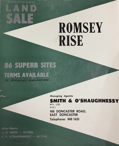
Plan - Subdivision Plan, Romsey Rise, Doncaster East
Real estate brochure for a land sale of 86 sites in East Doncaster. Roads identified in the plan include: George Street, Dennert Street, Worthing Avenue, Sandhurst Street, Belinda Crescent, and Romsey Rise.Historic subdivision plan of a Doncaster East EstateFour page colour real estate brochure including on page 2 a subdivision plan for the Romsey Rise estate in East Doncaster. This record also includes a separate price list for the lots.real estate plans, subdivision plans - doncaster east, romsey rise estate - doncaster east (vic) -
![Understanding Documents for Genealogy & Local History / [by] Bruce Durie](/media/collectors/550653872162f11fb04854aa/items/5ed04a3cdcf9cd08346b9695/item-media/5ed04b15dcf9cd08346ba396/item-fit-380x285.jpg) Kew Historical Society Inc
Kew Historical Society IncBook, The History Press, Understanding Documents for Genealogy & Local History, 2013
... , contracts, indentures, charters, land records, personal letters ...Genealogists and local historians have probably seen every birth, marriage, death and census record available, and are adept at unsing the internet for research. However, once they have learnt everything they can from them, the next step is reading and understanding older documents. These can be hard to find (not many are online), are often written in challenging handwriting and use legal and other unfamiliar terms. Some will be in Latin, antiquated English or Scots. Readers need to be able to understand the nature and intent of a range of documents as well as the palaeography (the handwriting) and orthography (the 'shape' of the contents). Documents covered include wills and testaments, contracts, indentures, charters, land records, personal letters, official records, Church records and others, mainly from the period 1560 to 1800. Also covered are dates, numbers, calendars, measurements and money, abbreviations, transcription conventions, letter-forms and glossaries, and it includes a Latin primer.448 pages : illustrations (black and white) ; 25 cm.Genealogists and local historians have probably seen every birth, marriage, death and census record available, and are adept at unsing the internet for research. However, once they have learnt everything they can from them, the next step is reading and understanding older documents. These can be hard to find (not many are online), are often written in challenging handwriting and use legal and other unfamiliar terms. Some will be in Latin, antiquated English or Scots. Readers need to be able to understand the nature and intent of a range of documents as well as the palaeography (the handwriting) and orthography (the 'shape' of the contents). Documents covered include wills and testaments, contracts, indentures, charters, land records, personal letters, official records, Church records and others, mainly from the period 1560 to 1800. Also covered are dates, numbers, calendars, measurements and money, abbreviations, transcription conventions, letter-forms and glossaries, and it includes a Latin primer.genealogy -- handbooks, local history -- archival resources., genealogy -- archival resources. -
 Kew Historical Society Inc
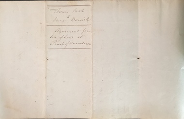
Legal record (Item), Thomas Judd to James Bonwick: Agreement for Sale of Land at Parish of Boroondara, 1853, 28/02/1853
James Bonwick (1817-1906), the Victorian educator and historian, acquired land in Kew on which to establish a home and school in 1853, not 1854 as more commonly stated. Bonwick returned to England in 1859 for a period, later returning to Melbourne and settling in St Kilda. He was the author of a number of histories and an official transcriber of Government records.This newly acquired document, from a former owner of 'Parkhill' (20 Hillcrest Avenue, Kew), is of statewide importance as it is the original copy of the agreement made between Thomas Judd of Parkhill and James Bonwick in 1853 for the purchase of land in Kew. Both Thomas Judd and James Bonwick were significant pioneers of Victoria.TRANSCRIPT [TITLE] Thomas Judd to James Bonwick Agreement for Sale of Land at Parish of Boroondara [PAGE 1] Articles of agreement made and entered into this the Twentyth eighth day of February One thousand Eight Hundred and fifty three Between Thomas Judd of Melbourne in the Colony of Victoria Gentleman of the one part and James Bonwick of Melbourne in the Colony of Victoria Gentleman of the other part whereby the said Thomas Judd agrees to sell unto the said James Bonwick who hereby agrees to purchase a piece or parcel of land containing two and half acres be the land more or less part of Portion Number Eighty five of the Parish of Boroondara in the County of Bourke commencing at a point on the Northern boundary line of the said Portion Seventeen Chains fifty links East from the North West angle of the same and bounded on the East by other part of said Portion in a line bearing South Eight Hundred and sixty two feet on the South by other part of said Portion Eighty five in a line bearing West one Hundred twenty six and half feet on the West by other part of said Portion Eighty five in a line bearing North Eight Hundred and Sixty two feet on the North by the Northern boundary line of the said Portion Eighty five in a line bearing East one Hundred twenty six and half feet to the commencing point at or for the price or sum of one [PAGE 2] One Hundred Pounds to be paid and payable in the manner hereinafter mentioned that is to say the Sum of Thirty pounds to be paid on the day of the date hereof and the sum of forty pounds by the acceptance of the said James Bonwick for that sum at three months bearing interest thereon after the rate of Eight Pounds per centum per annum and the Sum of Thirty pounds by the acceptance of the said James Bonwick for that sum after Six months with interest thereon after the rate of Eight pounds per centum per annum It is furthermore agreed that the said James Bonwick shall have access by a right of way fifteen feet wide reserved by the said Thomas Judd to the Government Road being the Southern Boundary of Portion Eighty five. That in case default shall be made in the payment of any of any of the Acceptances above mentioned the amount paid shall be actually forfeited to the said Thomas Judd who shall be at liberty to resell the premises. That upon payment of the whole amount of the purchase money the said Thomas Judd shall execute a conveyance of the premises to the said James Bonwick Such conveyance to be prepared by and at the expense of the said James Bonwick who - [PAGE 3] who shall also pay the cost of any attested copies he may require. ---- As witness the hands of the said parties this the twenty first day of February one thousand Eight Hundred and fifty Three. ----- [Signature] T. Judd [Signature] Jas Bonwick Witness [Signature illegible] £ Received Cash on account of the above 30.0.0 Thirty Pounds Bill at three Months with interest 42.4.0 Bill at Six Months with interest 31.4.0 _____ £103.8.0 _____ [Signature] T. Judd [Signature] Jas Bonwick ------------ Transcribed David White 25/08/2020 james bonwick, thomas judd, land titles - kew (vic), pioneers - kew - victoria -
 Kew Historical Society Inc
Clothing - Girl's dress, 1858
This dress belonged to Alice Frances Henty (1852-1932) the youngest daughter of Francis Henty (1815-89) and his wife Mary Ann Henty [nee Lawrence] (1821-81). It is recorded that Alice wore the dress at the age of six. Alice's father, Francis Henty, was the youngest son of Thomas Henty, who with his family, their retainers and property moved to the Australian colonies between 1829 and 1832. In 1834, Francis’ older brother, Edward, sailed from Launceston in Van Diemen’s Land to what was to become Portland in the western part of Port Phillip District [Victoria]. Francis, together with the first flock of Merino sheep [in Victoria], followed some months later. The first and second generations of the Henty family established vast pastoral properties in the Western part of the Port Phillip District. Francis Henty managed ‘Merino Downs’ near Casterton, while also living in his retirement at ‘Field Place' in Kew. The Henty Collection of nineteenth and twentieth century clothing, including outerwear and underwear, was collected, stored and exhibited over time by female family members descended from Francis and Mary Ann Henty. During the twentieth century, items from the collection were modelled in two fashion parades by various descendants [1937, 1959]. The items in the collection are historically and aesthetically significant, with provenance provided by oral and written tradition within or held by the family. A number of the items in the collection are very rare survivors, and provide researchers with the evidence needed to reconstruct the lives of notable women in the Port Phillip District [later Victoria] during the nineteenth and early twentieth century.Girl's two-tone, one-piece cotton voile dress from the 1850s has a high round neck and short sleeves has a lace insert on the front of the bodice and matching lace at the rear. The layered skirt is bordered with lace. Measurements (mm): Girth - Neck 609.6, Chest 635, Waist 558.8, Cuff 203.2, Hem circumference 2108.2. Vertical - Front neck to hem 685.8, Front waist to hem 508, Back neck to hem 723.9, Back waist to hem 534.4, Sleeve length 63.5. Horizontal - Neck to sleeve head 38.1, Cross back 304.8, Underarm to underarm 406.4.fashion -- 1850s, children's clothing, alice frances henty -
 Kew Historical Society Inc
Photograph - Yarra in Flood from Willsmere, North Kew, 1923
Flooding of the Yarra Valley, including that section of the Yarra bordering Kew and Kew East in the north and west of the municipality, was a regular occurrence. Extreme flood events of the Yarra River are recorded to have occurred in 1891, 1901, 1916, 1923 and 1934. The Municipality of Kew's response to these floods was to enact planning decisions restricting residential development in flood prone areas following the floods of 1916, 1921 and 1934. While floods continued after the development of the Upper Yarra Reservoir (construction 1948-57), the regularity and extent of these inundations diminished. Original, large sepia photograph showing men, women and children who have gathered on a grassy verge, probably farm land, to look out across the flooded Yarra Valley at Willsmere, North Kew. In the medium distance are three houses that are largely submerged by the flood waters as well as a number of Eucalypts. Judging by the clothes of the spectators, the date might be 1901 or 1916, but probably the latter due to the hats worn by a number of the women. Inscribed reverse: "Gift of Kerrie Woollard (KCC) (P)C.1923yarra river valley, kew east (vic.), floods, willsmere