Showing 580 items
matching large shops
-
 Kew Historical Society Inc
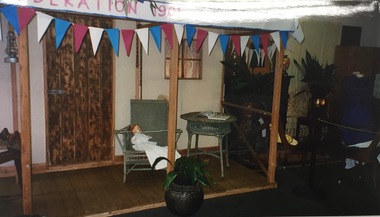
Photograph, Kew Historical Society, Historical Display, Kew Festival, 2001, 2001
The Kew Historical Society, founded in 1958, is one of the oldest continuing historical societies in the Greater Melbourne region. For over 60 years, the Society has worked with local government and other community organisations to stimulate interest in Kew’s history and heritage. From its beginnings, the Society held local exhibitions, sometimes in shop windows, on other occasions in civic halls, and now at the Kew Court House and Kew Library. This and other photos taken in the same year are examples of an exhibition in the Phyllis Hore Room at the Kew Library. The modern kew Festival wa initiated in 1974. Initially held every two years, it soon became an annual festival. The Society was a founding participant in the festival, mounting regular displays and participating in marches. In 2001 they mounted a large display in the Phyllis Hore Room of the Kew Library.Photograph of historical items displayed by Kew Historical Society in the Phyllis Hore Room at the Kew Library during the 2001 Kew Festival.kew historical society - exhibitions, kew festival --2001 -
 Kew Historical Society Inc
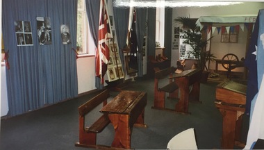
Photograph, Historical Display, Kew Festival, 2001
The Kew Historical Society, founded in 1958, is one of the oldest continuing historical societies in the Greater Melbourne region. For over 60 years, the Society has worked with local government and other community organisations to stimulate interest in Kew’s history and heritage. From its beginnings, the Society held local exhibitions, sometimes in shop windows, on other occasions in civic halls, and now at the Kew Court House and Kew Library. This and other photos taken in the same year are examples of an exhibition in the Phyllis Hore Room at the Kew Library. The modern kew Festival wa initiated in 1974. Initially held every two years, it soon became an annual festival. The Society was a founding participant in the festival, mounting regular displays and participating in marches. In 2001 they mounted a large display in the Phyllis Hore Room of the Kew Library.Photograph of historical items displayed by Kew Historical Society in the Phyllis Hore Room at the Kew Library during the 2001 Kew Festival.kew historical society - exhibitions, phyllis hore room, kew library -
 Kew Historical Society Inc
Plan, Melbourne & Metropolitan Board of Works : Borough of Kew : Detail Plan No.1573, 1905
The Melbourne and Metropolitan Board of Works (MMBW) plans were produced from the 1890s to the 1950s. They were crucial to the design and development of Melbourne's sewerage and drainage system. The plans, at a scale of 40 feet to 1 inch (1:480), provide a detailed historical record of Melbourne streetscapes and environmental features. Each plan covers one or two street blocks (roughly six streets), showing details of buildings, including garden layouts and ownership boundaries, and features such as laneways, drains, bridges, parks, municipal boundaries and other prominent landmarks as they existed at the time each plan was produced. (Source: State Library of Victoria)This plan forms part of a large group of MMBW plans and maps that was donated to the Society by the Mr Poulter, City Engineer of the City of Kew in 1989. Within this collection, thirty-five hand-coloured plans, backed with linen, are of statewide significance as they include annotations that provide details of construction materials used in buildings in the first decade of the 20th century as well as additional information about land ownership and usage. The copies in the Public Record Office Victoria and the State Library of Victoria are monochrome versions which do not denote building materials so that the maps in this collection are invaluable and unique tools for researchers and heritage consultants. A number of the plans are not held in the collection of the State Library of Victoria so they have the additional attribute of rarity.Original survey plan, issued by the MMBW to a contractor with responsibility for constructing sewers in the area identified on the plan within the Borough of Kew. The plan was at some stage hand-coloured, possibly by the contractor, but more likely by officers working in the Engineering Department of the Borough and later Town, then City of Kew. The hand-coloured sections of buildings on the plan were used to denote masonry or brick constructions (pink), weatherboard constructions (yellow), and public buildings (grey). This plan has detailed annotations written in red or blue ink, showing prices, which may be the annual valuations of the properties, and some owners’ names, a most unusual feature on contractor's maps. Some areas, such as the buildings of Methodist Ladies’ College (MLC), include the school’s tennis court and swimming pool, but are not coloured to show building materials – did the draftsman just run out of time, or ink, or enthusiasm, before his plan had to be submitted? MLC had been founded in 1882 as a ‘modern school of the first order’ with buildings that formed ‘a collegiate institution for girls unsurpassed in the colonies’. The goal of its founders was to provide a high-class Christian education for girls, comparable with that provided elsewhere for boys. Some shops are shown along Edgevale Road, though they are not designated as commercial premises. Larger houses are depicted, including ‘Fairlawn’ in Barkers Road, and ‘Clevedon’ and ‘Rosehill’ (now demolished) in Fitzwilliam Street.melbourne and metropolitan board of works, detail plans, mmbw 1573, maps - borough of kew, cartography -
 Surrey Hills Historical Society Collection
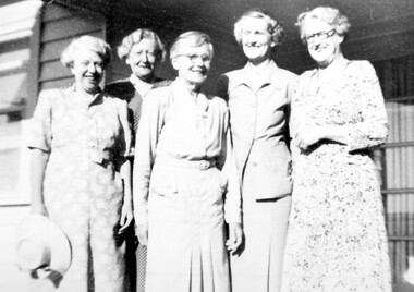
Photograph, Miss Jane Elizabeth (Jean) Pearson and her sisters in 1952, 1952
Miss Jane Elizabeth (Jean) Pearson is second from the left. From c1927 - c1950 Miss Pearson had the cake and confectionery shop at 147 Union Road. It was later a milk bar, next to Henry Jamieson’s radio and electrical shop. Miss Pearson sold Farey’s cakes which were very popular and in a trellised-off section also served morning and afternoon teas. Her sisters often helped. Silversticks, white knights, licorice straps were among a wide selection of sweets to be bought for 1d. – or even ½d. Jean was one of a large family born to John William Pearson and Agnes Yeaman. Jean was born at Riddell's Creek in c1884. She died in 1966. She had 3 brothers and a total of 6 sisters. Lillias Irene and Grace Stewart died in infancy or childhood, so the other sisters in the photo were (not necessarily in order): Ethel Agnes born in 1885, who married James Charles Robertson; Catherine Myra born in 1887, unmarried; May Dempster born 1891, unmarried; and Stella Christie born 1897, who married Cecil Hunt Aston in 1928. Jean was in business as a confectioner at 3 High Street, Malvern in 1927; in Union Road 1941-1949 and resided (presumably in retirement) at 37 Mayston Street, Hawthorn in 1954. At the later address May and Catherine are also listed variously in 1954 and 1963. (Ref: electoral rolls). The Hawthorn address was the 'family home' - address of John William Pearson who died in 1944, appointing Jean as his executrix. (Ref: Trove - The Argus 19 July 1944) Black & white copy of a group of 5 smiling older women with a strong family resemblance against a weatherboard background.147 union road, (miss) jean pearson, surrey hills, milk bar, shops, confectionary shop, cake shop, tea rooms, (miss) jane elizabeth pearson, (miss) ethel agnes pearson, (mrs) ethel agnes robertson, (miss) catherine myra pearson, (miss) may dempster pearson, (miss) stella christie pearson, (mrs) stella christie aston, (mr) john william pearson, (miss) agnes yeaman, (mrs) agnes pearson -
 Surrey Hills Historical Society Collection
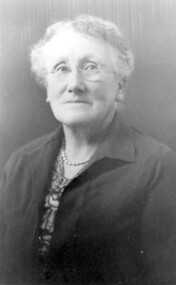
Photograph, Mrs Florence Margaret Tacey (nee Edwards)
Mrs Florence Margaret Tacey (nee Edwards) was the mother of Albert Arthur Tacey. She was born in 1863; died in 1943 in Camberwell. Her husband was William Tacey born in the Buckland Valley near Bright in 1857. There were many members of the Tacey family who were butchers. Various members of the family were associated with Tacey's Butchers at 629 Canterbury Road, Surrey Hills. According to a Context P/L heritage assessment of the property the land on which the business was built "was purchased by Edward Tacey on 16 September 1889. Edward Tacey was a butcher and the Sands & MacDougall street directory indicates that a butcher’s shop had been constructed on the site and was operating by 1890. It seems that the family lived for some time at a house located next door to the shop at 627 Canterbury Road (visible on the 1909 MMBW plan, but since demolished). On 15 June 1920 Edward Tacey transferred all three blocks of land to Joseph Tacey, most likely his son * and also a butcher, who carried on business from the same premises. Joseph Tacey died on 20 February 1933, after which administration of his estate (which included the three blocks of land) passed to his widow, Mary Dorothy Tacey." Edward Tacey (1863 - 1952) was the brother of William Tacey (1857 - 1920). The property passed to Joseph Charles Tacey (1887 - 1933), his nephew and son of William, not his son. His wife was Mary Dorothy Coates. Albert Arthur Tacey was a brother of Joseph Charles Tacey. The SHNCHC has a large framed photo collage of the Tacey butcher's shop at 629 Canterbury Road. It hung in various Tacey family-owned butcher's shops around Victoria before coming back to Surrey Hills. The donor was the daughter of Albert Arthur Tacey (1902-1959). A black and white photograph of an older lady. She has greying hair, is wearing rimless glasses, pearls and a jacket over her dress.surrey hills, butchers, mrs florence margaret tacey, miss florence margaret edwards, william tacey, joseph charles tacey, albert arthur tacey -
 Surrey Hills Historical Society Collection
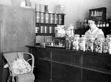
Photograph, Anne's Pantry, 165 Union Road, Surrey Hills in 1947
In 1930 Miss Anne Cook opened Anne’s Pantry, a home-made cakeshop at 165 Union Road, but later moved to 135 Union Road. The business of the same name is currently (2018) located at 139 Union Road. Miss Cook used to catch the first train up from Auburn and usually worked into the evening. Eventually the long hours took their toll and she had to sell. Miss E Porteous, her assistant, pictured in this photo, remained for many years with later owners. She recalled: “On the first day we opened at 10 a.m., the people surged in and within half an hour there wasn’t a cake left.” A black and white photograph of a shop interior. There are a number of large jars full of biscuits sitting on the counter. Large tins and boxes are on the shelf to the left hand side. A wicker chair is beside the counter, and part of a table and chair is on the far left hand side. A lady with glasses is standing behind the counter.Original: Top LH corner: Just in case / you forget / Anne's Pantry / 1947 Top Middle: PS/ How could we forget / love Mumunion road, businesses, surrey hills, cake shop, pastry shop, shopkeepers, 1930, 1947, anne's pantry, e. porteous (miss), anne cook (miss) -
 Surrey Hills Historical Society Collection
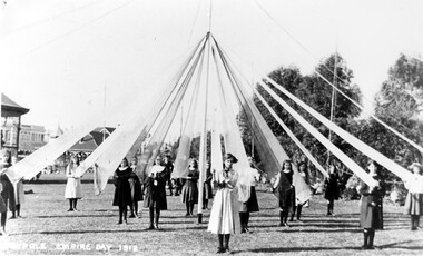
Photograph, Maypole dancing, Empire Day 1912, 1912
Black and white photo taken in the Canterbury Gardens of 15 girls from Surrey Hills State School taking part in maypole dancing. (Others are beyond the range of the photo.) The girls are not uniformly dressed but each holds a large ribbon. Part of the bandstand can be seen to the left of the photo. The Canterbury Library is the large building in the near background; further in the distance are some of the double-storey shops along Canterbury Road. Two of the girls are Elsie Wappet (nee Sherar) and Doris Turnball (nee Dixon). Lower LH corner: "MAYPOLE EMPIRE DAY 1912"empire day, surrey hills state school, surrey hills primary school, festivals and celebrations, maypole dancing, post card, doris turnball, doris dixon, elsie sherar, elsie wappet, canterbury gardens, rotunda, canterbury library -
 Surrey Hills Historical Society Collection
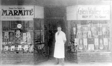
Photograph, Edward Blanchford Wright's grocery shop, Canterbury Road, Surrey Hills
Edward Blatchford Wright was born in 1894 in Birmingham, son of Edward Wright and Florence Emuss. It is not known when he migrated to Australia but he served in the AIF during WW1, seeing action in France. On enlistment aged 20 years 9 months, he gave his occupation as farmer. He married Gertrude Matilda Wain in 1919. He came to Surrey Hills c1924. He was a grocer in the area for several decades with shops in Canterbury Road. In 1942 he is listed at 235 Union Road. This was a residential address. Alan Holt's Surrey Hills property register places him at 365 Canterbury Road (c1920-1930) and 359 Canterbury Road (c1930-1940). He died in 1972 in Mont Albert. His last electoral roll entry in 1968 gives 18 Serpentine Street, Mont Albert. He and his wife are buried in Burwood Cemetery.Black and white photo of the exterior of Edward Blanchford Wright's grocery shop in Canterbury Road, Surrey Hills. The screen door is open and William Reynolds stands in the opening, dressed in a long white coat. The window displays are stacked high with cans and packages and large signs advertising the prices of goods. There is advertising on the windows for Marmite, Glen Valley tea, Preservene soap and Brockoff's biscuits. advertising, shops, grocers, businesses, union road shops, edward blatchford wright, william reynolds, burwood cemetery, world war 1, canterbury road -
 Surrey Hills Historical Society Collection
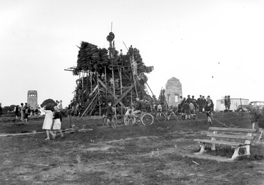
Photograph, Bonfire, Beckett Park, Balwyn (Surrey Hills), c1937/8, 1937
"The bonfire at Beckett Park was the culmination of the EMPIRE DAY/CELEBRATIONS in Surrey Hills in 1935 and 1936. In 1937 vandals lit the fire prematurely but residents hastily rebuilt it - about / 100 tons including old tyres. A volunteer fire-watcher had his caravan close by until lights-up time on Saturday night. / Courtesy Ian Barkla. / see 180 (handwritten on backing board)." / "BONFIRE BUILDING at BECKETT PARK/EMPIRE DAY CELEBRATIONS IN 1930s/ The celebrations were centred on the/ shopping centres in Surrey Hills and/Mont Albert to boost local business (and/ the spirits of residents) after the Depression./ - from a glass negative - Mr Ian Barkla."Image depicting the building of a large bonfire made primarily from rubber tyres, supported by a wooden frame c1937/8. There is a significant crowd of people watching the erection of the pyre from ground level. Several members of the crowd are seated or holding bicycles. There are multiple persons situated on the pyre or on a ladder propped up against the mound of tyres. The area containing the pyre has been fenced off with rope (?). A white coloured caravan in situated to the right (facing) of the bonfire in close proximity to a dark coloured car. Two stone towers and a park bench are also visible in the image.Black and white, W 25.3 cm x H 20.3 cm, landscapeparks and reserves, beckett park, balwyn, bicycles, crowds, empire day, depression 1929-1939, economic depression, frank leslie barkla, bonfires -
 Surrey Hills Historical Society Collection
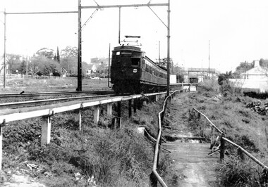
Photograph, At Surrey Hills - Railfan tour to Belgrave for the South Pacific Electric Railway Group, 1 October 1966
We have an original copy donated by Iam Barkla and a larger one copied by Ken Hall. The Barkla original has a sticker with his reference details on the back. The occasion was a Railfan tour for the South Pacific Electric Railway Group to Belgrave. Photo taken on 1 October 1966. A black and white photo of an electric train near the Surrey Hills railway station. The shops in Union Road, the pedestrian overpass at the station and houses in Windsor Crescent can be seen in the background.surrey hills railway station, railfan tour, south pacific electric railway group, 1966, union road shops, windsor crescent -
 Surrey Hills Historical Society Collection
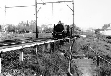
Photograph, Loco N 468 at Surrey Hills on Railfan Tour to Healesville for the Australia Railway Enthusiasts Group, 1 October 1966
We have an original copy donated by Iam Barkla and a larger one copied by Ken Hall. The Barkla original has a sticker with his reference details on the back. The occasion was a Railfan tour to Healesville for the Australian Railway Enthusiasts Group. Photo taken on 1 October 1966. A black and white photo of steam train. Some of the houses in WIndsor Crescent can be seen on the left hand side of the photograph; also some of the Union Road shops and the pedestrian overpass at the Surrey Hills station.surrey hills railway station, 1966, railfan tour, australia railway enthusiasts group, union road shops, windsor crescent -
 Brighton Historical Society
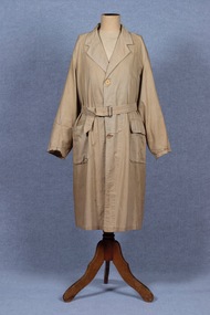
Coat, Dustcoat, c.1948
Dust coat worn by Mr Frederick Alister Jennings when he managed a family grocery store circa 1948 at 510 Point Nepean Road, East Brighton. Frederick was born at Nagambie, Victoria in 1909 and died in Brighton in 1979. He was the son of Hugh Edwin Jennings and Alice Constance Warren. He married Margaret Jean Hughes in 1934 and served in the Second World War. He lived at 1 Valda Grove Brighton. Frederick was a commercial traveller as well as his time spent managing the store in Point Nepean Road. It is believed this coat dates from his time at the store c1948 - 1955. The store was owned for many years by his father-in-law W. G. Hughes and was one of a group of shops near the corner of Centre Road. In 1944-45 the group of shops included Fletcher’s fuel merchants, a haberdasher, butcher, fruiterer, grocer, Brighton East post office, a ladies’ hairdresser and Hughes’ grocer. In 1950 Hughes’ grocery store was between a service station and the Commercial Bank on what had been renamed Nepean Highway. The business was sold to G. S. Maynard, grocer, sometime before 1960.Unlined dustcoat of beige cotton. Fastens centre front with three brown plastic buttons. Two large patch pockets. Separate cloth belt with metal buckle. Signs of wear and mending. .1 - coat .2 -beltGarment label reads: APEX (RLG.) Dust Coat DEPT. MYER STORE for MEN. MELBOURNE & ADELAIDEdustcoat, occupational dress, grocer, hughes grocery store, brighton, frederick alister jennings -
 Vision Australia
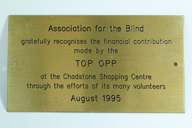
Photograph - Image, Top Opp recognition plaque
Part of the AFB network of fundraising involved the use of opportunity shops in various locations. The Top Opp was a large contributor and the work of those who volunteered is acknowledged in this plaque.Gold coloured metal plate with black writingAssociation for the Blind gratefully recognises the financial contribution made by the Top Opp at the Chadstone Shopping Centre through the efforts of its many volunteers August 1995association for the blind, fundraising -
 Port Fairy Historical Society Museum and Archives
Photograph
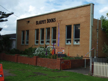
this building was built to house the Port Fairy Masonic Lodge No 67 with two seperate large spaces a general l meeting room in the front and the formal Lodge space to the rear. it is now occupied as a book shop by ‘Blarney Books’Coloured photograph of brick fronted building housing Blarney Booksshop, commercial, port fairy masonic lodge no.67, blarney books, books -
 Port Fairy Historical Society Museum and Archives
Container - Tin, Glaxo Laboratories, 1930's
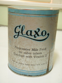
Glaxo's Port Fairy Factory was built in 1929 as a milk factory it had a tin shop where the tins were manufactured and the milk was dried and sold as some of the first formula milk for babieslarge tin with printed information "Glaxo" progressive milk food for older infants enriched with Vitamin D Blue bands and silverGlaxo Progressive milk food for older infants enriched with Vitamin D Young or delicate babies should have Glaxo No 1. Table of quantities and directions for useglaxo, factory, princes highway, manufacturer, milk, baby food -
 Port Fairy Historical Society Museum and Archives
Postcard, Mail Car Orford
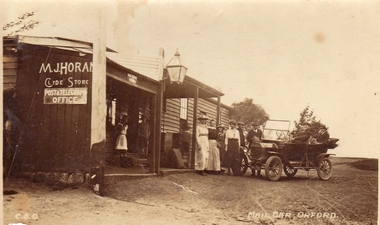
M.J.Horan's post office and general store with the mail car out the frontBlack & white photograph of a weatherboard building (shop) with a verandah and a large lantern in front and carMail car Orford Real Photo Post card, the "Rose" series deluemail, car, orford, m.j.horan, post office, store -
 Port Fairy Historical Society Museum and Archives
Drawing - large picture, Webb Bros Cordial Factory
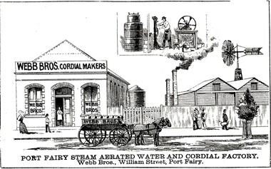
This lithograph shows William Webb's Cordial and Aerated Waters factory on William Street. An 1887 plan shows three buildings forming part of the factory. Black & white etching of Large building of Webb Bros Cordial factory with delivery cart out front and lower wooden buildings to the leftPort Fairy Steam Aerated Water and Cordial Factory Webb Bros. William Street Port Fairyfactory, business, shop -
 Vision Australia
Container - Object, Cane large basket
Basket weaving and brush making was a source of income for those who worked in the workshops at RVIB and other institutions in New South Wales and Queensland. A diverse range products could be produced with cane, such as cane chairs, cots, washing baskets and trolleys, and the Institution sought to highlight these in the annual report. Over time the demand for, and supply of, cane changed - particularly during World War 2 when Asian sources were under attack or destroyed. At home, other materials such as plastics as well as the ability to import cheaper pre-produced products further reduced the demand for workshop pieces. This laundry basket was reinforced with a solid heavy base that gave it both strength and the ability to remain upright as clothing items were placed inside. This cane laundry basket made in the basket shop of RVIB for use in the organisation possibly between 1930-1940, not for sale. Held with staff in the Enterprises section since the move to 201 High Street in the early 1990s.1 cane basket with lidroyal victorian institute for the blind, employment -
 Vision Australia
Functional object - Object, Wooden donation boxes, 1970-1990
Coin collections have a long and varied history. Coins were often collected in churches in a box located near the entrance/exit, and later via a collection plate that was passed amongst the congregation Funds were used to repair the church or feed the poorest of the parish. The donation of coins is and was considered part of religious life and mentioned in Christian, Jewish and Islamic texts. With the need and expansion of charitable works occurring outside religious life, charity boxes began to spread into hospitals, orphanages and asylums. The need for non-fixed boxes grew with the rise in charities and their activities outside a fixed building. Collection boxes could be large (and therefore hard to move) or could be held by individuals acting as collection agents, working at a specific location, moving between dwellings or at events. In this example, the boxes were placed in a semi-permanent location, such as a shop counter or bar, for people to donate money. Periodically it would be emptied by a collector, who either unlocked the padlock that was usually attached or replaced it with a new box.2 wooden boxes with paper label, perspex or glass,metal hinges and locking mechanism.Blind Babies, Children & Adults Royal Victorian Institute for the Blind Phone 51 1381 All services provided by the RVIB are free - thanks to your helproyal victorian institute for the blind, fundraising -
 Vision Australia
Functional object - Object, RVIB Wooden donation boxes, 1970-1990
Coin collections have a long and varied history. Coins were often collected in churches in a box located near the entrance/exit, and later via a collection plate that was passed amongst the congregation Funds were used to repair the church or feed the poorest of the parish. The donation of coins is and was considered part of religious life and mentioned in Christian, Jewish and Islamic texts. With the need and expansion of charitable works occurring outside religious life, charity boxes began to spread into hospitals, orphanages and asylums. The need for non-fixed boxes grew with the rise in charities and their activities outside a fixed building. Collection boxes could be large (and therefore hard to move) or could be held by individuals acting as collection agents, working at a specific location, moving between dwellings or at events. In this example, the boxes were placed in a semi-permanent location, such as a shop counter or bar, for people to donate money. Periodically it would be emptied by a collector, who either unlocked the padlock that was usually attached or replaced it with a new box.2 wooden boxes with paper label, perspex or glass,metal hinges and locking mechanism.Blind Babies, Children & Adults Royal Victorian Institute for the Blind Phone 51 1381 All services provided by the RVIB are free - thanks to your helproyal victorian institute for the blind, fundraising -
 Federation University Art Collection
Artwork - Ceramics, Ceramic Forms by Elsa Adern
Elsa ADERN (1918-2006) Born New Zealand Arrived Melbourne 1942 Elsa Ardern was living at Warrandyte in 1954 when she started studying pottery under John Bernard Knight at the Melbourne Technical College. In 1961 she was a founding member of Potters' Cottage at Warrandyte with friends Sylvia Halpern and Kate Janeba. She worked from a studio under the family home, exhibiting at the cottage and also through the Victorian Ceramic Group when it was set up in 1969. In 1980 she established a workshop at Tathra on the far south coast of NSW, sharing her time between Tathra and Warrandyte for the next 25 years. Amongst the work made at Tathra were some very large pieces which she fired in the Stafford Brothers' wood-fired brick-kiln at Kalaru. Part of the clay for these came from the Staffords' clay-pits. Elsa Adern is known for her strong form of her pots, enhanced by her characteristically subtle wood-ash glazes. Her works are signed with an incised 'Elsa Ardern' or 'EA'. (http://www.australianpotteryatbemboka.com.au/shop/index.php?manufacturers_id=32)available, elsa adern, available ceramics, ceramics -
 Falls Creek Historical Society
Photograph - Harold and Jean Cuming with staff
Cuming's Ski Hire was an early establishment in Falls Creek, owned and operated by Harold and Jean Cuming. Located in Main Falls Creek Road only 70 yards from the top station of the chairlift, it had a wide range of skis for hire and many other accessories for sale. It also operated simple accommodation, a cafe and apres ski shop. The business changed hands and the cafe had many names throughout its history. It was the centre of many activities - including skiers using the roof as a ski jump!This image is significant because it depicts Harold and Jean Cuming and staff from the Cuming's Ski Hirage Centre at Falls Creek, Victoria.A black and white photo of the Harold and Jean Cuming with staff and a large snowmancuming's ski hire, harold cuming, jean cuming, ski hire falls creek -
 City of Greater Bendigo - Civic Collection
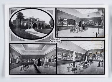
Souvenir - Reproduction of postcard, Bendigo Art Gallery
Bendigo Art Gallery was founded in 1887 and has over the years undergone extensive building and renovation programs in recent years adding a new contemporary wing, storage areas, and a new entrance and gallery shop. This photographic reproduction of an older post card shows the interior of the rooms now known as the 'historic courts' and an exterior front view c. 1910. Photographic reproduction of unknown post card. Possibly larger than original size. Writing on reverse. Believed to be related to Cat No 0306.Reverse: BENDIGO ART GALLERY 1910 / "The interior architecture remains / largely the same.' / *This photograph is the property / of the Bendigo Art Gallery, and / should be returned promptly.bendigo art gallery, city of greater bendigo tourism -
 Melton City Libraries
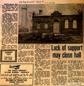
Newspaper, Lack of support may close hall, 1977
"The Mechanics Institute movement flourished in Victoria from 1839 to 1950. It was based on the development of Mechanics’ Institutes in Scotland and England from the 1820s, which were intended to educate and enlighten the working classes. The term ‘mechanic’ in those days meant an artisan, craftsman or working man, especially those who had moved from rural areas to work in new city factories during the Industrial Revolution. The early Institutes were usually equipped with a reading room, a library and a lecture room. Although enjoying mixed success in Britain, they contributed to the development of public education and library services. The movement was adopted more enthusiastically in the colonies. It began slowly in Victoria but its expansion after the gold rushes population influx was rapid, especially in rural areas. Every suburb and town wanted to have a Mechanics’ Institute. During the 1850s approximately forty Institutes were established, with even greater growth in the period 1860 to 1900. By 1900 there were 400 Institutes in Victoria. The establishment of a Mechanics’ Institute was often a great achievement for a local community, requiring organising committees to raise substantial funds for a building site (where this had not been granted by the Government), and the building. Once built, the committee then had to purchase books, provide a caretaker or librarian, and finance the ongoing use of and improvements to the building. ‘The history of many Institutes is a story of tremendous community effort, and often, financial difficulties’. In addition to being monuments to local enterprise and community life, the Mechanics’ Institutes played a vital role as an intellectual forum, and in contributing to an informed and participatory democracy in the late nineteenth and early twentieth centuries. They provided journals and other reading matter on local, state, national and international issues, and hosted of lectures and held debates about wider issues such as Federation, colonial nationalism, defence, female suffrage, the price of land and labour. With the development of the school and technical education in the latter part of the nineteenth century, the need for community technical and adult education declined. As a result of the introduction of government library grants in 1867, many Mechanics’ Institutes incorporated a free library in their buildings to finance collection of their books. By 1884-85, there were 257 free libraries in Victoria. However, government support and library grants dropped off in the 1890s depression. Entertainment took on a greater role in the 1890s, with the introduction of moving pictures, billiards rooms, games rooms (chess), concerts and dances. The First World War had a devastating impact on many rural communities, and some Mechanics’ Institutes were no longer viable. On the other hand the early twentieth century was also a time of agricultural development, and many country towns were growing in this period. The 1930s depression further limited growth of many libraries and reduced grants substantially. In response many Mechanics’ Institutes were renamed, for example as memorial halls, in order to retain and attract more patrons (eg at nearby Sunbury). The diminishing role for Mechanics’ Institutes and the preference for larger and better appointed halls (with supper rooms, cloak rooms etc) resulted in demolition of some small Institutes. The advent of cars, radios, and television also provided other opportunities for recreation, learning and entertainment. The greater role of municipalities in providing library services also eroded the need for free libraries. While over 500 Mechanics’ Institutes or halls are extant, very few of these retain their original role as ‘diffusers of useful knowledge’. Most are still available for community purposes, as venues for meetings, socials, civic occasions etc, while others are employed as museums, shops and theatres. Most buildings are on Crown land, and managed by a delegated committee of management, who are responsible for raising revenue to maintain aging buildings. Many of those which were originally established on private land, such as Melton, have since reverted back to the Crown, and municipal Councils. The most common Mechanics Institute building form is the simple weatherboard gable building with iron roofs, notable for their ‘honest simplicity’ rather than as ‘monuments of the ancients’. At the other extreme there are some magnificent two storeyed brick and stucco structures with elaborate ornamentation (as was apparently envisaged by some in Melton in 1905-10)". The future of Melton Mechanic Institute Gazette articlelocal architecture -
 Mont De Lancey
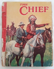
Book, Renwick of Otley, The Chief, early c.1900's
a collection of short adventure stories written for boysQuite a damaged large thin format storybook for boys - the front and back covers are detached and depict a coloured illustration of an Indian chief, two other Indians and a European man all on horses. On the back of the front cover is printed bookplate - This book belongs to..... Inside there are black and white illustrations. There is a separate loose page presumed to be part of the original book, a coloured picture of a schoolboy standing outside a Tuck Shop taking money out of his pocket to buy sweets. There is a short poem at the bottom of the page and the title - That Empty Feeling is written about the overall picture. At the top is an inscription written in ink, To Lance with all good wishes from Auntie Ada and in pencil - Xmas 1932.fictiona collection of short adventure stories written for boys children's stories, adventure stories -
 Parks Victoria - Mount Buffalo Chalet
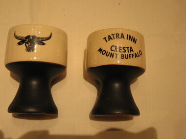
Mugs / goblets, 1964 - 1975
Found in an opportunity shop in Melbourne and purchased by the donor. 'Souvenirs in relation to the Chalet and Mount Buffalo were first mentioned in December 1912... A large range of souvenirs has since been associated with the Chalet and Mount Buffalo from crafted wooden items, silver spoons, cups etc... The collection includes a broad selection of products that have been sold throughout much of the Chalet's history, each representative of the transient fashions of their period.' (Pg 114. Historica) Tatra Inn was built in 1964, after an Act was passed in 1960 to allow private development leases in national Parks. The lease was terminated in 1975 and Tatra was taken over by the Government. Tatra was renamed the Lodge throughout the Belles 10 years management, from 1993.Listed in Draft Inventory of Significant Collection Items . Appendix A.3. Souvenirs. (Pg 168. Historica).A pair of ceramic mugs / goblets. The foot is black and the top of these mugs is sandy coloured with a black buffalo and a black inscription on reverse sideTATRA INN CRESTA MOUNT BUFFALO -
 Parks Victoria - Mount Buffalo Chalet
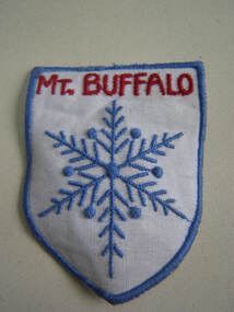
Badge
'Souvenirs in relation to the Chalet and Mount Buffalo were first mentioned in December 1912... A large range of souvenirs has since been associated with the Chalet and Mount Buffalo from crafted wooden items, silver spoons, cups etc... The collection includes a broad selection of products that have been sold throughout much of the Chalet's history, each representative of the transient fashions of their period.' (Pg 114. Historica) Manufactured as a souviner of MtBuffalo. Intended to be used, sewn onto a jacket sleeve. Purchased from an opportunity shop and donated.Listed in Draft Inventory of Significant Collection Items . Appendix A.3. Souvenirs. (Pg 168. Historica).White cotton badge in a shield shape. Has blue machine embriodery around edge and sewn in the centre to represent a snowflake. "MT.BUFFALO" is embriodered in red across the top."MT.BUFFALO" -
 Parks Victoria - Mount Buffalo Chalet
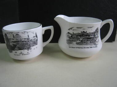
Crockery
The jug and cup were purchased from a second - hand shop in Bairnsdale. Jug is older than cup as the chalet is represented as a single storey structure. The cup is later as the second storey appears in the illustration. 'Souvenirs in relation to the Chalet and Mount Buffalo wee first mention in December 1912... A large range of souvenirs has since been associated with the Chalet and Mount Buffalo from crafted wooden items, silver spoons, cups etc... The collection includes a broad selection of products that have been sold throughout much of the Chalet's history, each representative of the transient fashions of their period.' (Pg. 114. Historica) 'A group of tableware items is notable for its black transfer printed decoration, which features the Chalet building. Interestingly, the printed designs represent the Chalet at two different stages in its building history under the Victorian Railways, in 1926 after completion of the north wing, and 1937-39, after the second storey is added to the front.. manufactured in England by A.B. Jones and sons, a Stoke on Trent pottery firm which operated under the trade name of Grafton China between 1900-1972.' (Pg. 114. Historica)Listed in Draft Inventory of Significant Collection Items . Appendix A.3. Souvenirs. (Pg 168. Historica)..1] Ceramic jug. Souvenir of Mt Buffalo. White ceramic squat milk jug with a black transfer illustration/drawing on front side. Picture is of the MtBuffalo Chalet from the front. Some worn gold glaze detail. It appears to be a single story building with a planted garden at the front with a fence. Trees to one side and people walking up steps. "THE CHALET, MT BUFFALO NATIONAL PARK, VICTORIA." is written under the illustration. Jug has a faint crack. .2] White ceramic cup with gold edging around top of cup. Black transfer drawing of the chalet with a second storey. Rocks and tree in foreground and "THE CHALET. MT BUFFALO." underneath transfer. .1] "THE CHALET, MT BUFFALO NATIONAL PARK, VICTORIA." is written under the illustration. On the base of the jug, with sun motif, "ENGLAND / GRAFTON CHINA /A / B J / & SONS / LOFTUS MORA / PTY. LTD" .2] "THE CHALET. MT BUFFALO." underneath transfer. Under cup, "A.B.J. / GRAFTON / CHINA / MADE IN / ENGLAND" -
 Bacchus Marsh & District Historical Society
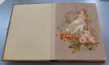
Album, Jeremeas Family Album of Photographs of Bacchus Marsh and District in 1883 by Stevenson and McNicoll
In late 1883 the Melbourne based photographers Stevenson and McNicoll visited the Bacchus Marsh township and nearby districts. They are known to have been visiting the town in September 1883 and by November 1883 they were reported to have moved on to Myrniong and Ballan. During their visit they took numerous photographs. The images produced comprise scenes of shops and businesses in Bacchus Marsh, public buildings like the Court House and Bacchus Marsh Primary School, houses and their owners and several broader views of streets. The photos were then offered for sale. Photography businesses also sold albums for purchasers to display their photos.A unique and comprehensive set of images of people and places in the Bacchus Marsh town and district at a particular period in time, September-November 1883. This album of "carte de visites" photographs presents a rare compilation of the work of the Stevenson and McNicoll photography business. This team of photographers are known to have made several visits to towns and districts in the rural areas of Victoria and southern New South Wales in the 1880s and this album represents a very rare example of their non-portrait photography. The album is an example of the Victorian middle-class fashion to display family photographs for themselves and their visitors. These albums were often very expensive and in themselves evidence of the affluence of the family. They were made possible by the popularisation of photography as a social medium and were a forerunner of the coffee-table book. Medium sized leather-bound album, brown, front cover engraved with gold tooling in a starburst pattern. Pages are gold-lined. The inside front and end covers are in pale blue silk embossed with a gold floral pattern. The metal locking clasp is broken. The front page has a floral wreath of roses and forget-me-nots and a dragon-fly. The word "Album" is in the centre of the wreath, printed in gold in Gothic print. There are nine pages with pockets for four 65mm x 105mm sized "carte de visites" style photographs. Several feature pages have a single pocket for a larger photograph, or double pockets, possibly designed for family portraits. These portrait pages are also decorated with floral wreaths and insects, reflecting the theme of the frontispiece page. The smaller photos in the album were taken by the Melbourne photographers Stevenson and McNicoll, There are 48 of these smaller images. The images were created around September 1883 when photographers for Stevenson and McNicoll are known to have visited Bacchus Marsh and district. The images comprise scenes of shops and businesses in Bacchus Marsh, public buildings like the Court House and Bacchus Marsh Primary School, houses with their owners and several broader views of streets. References to various photos being created and being available for sale are mentioned in the Bacchus Marsh Express newspaper during September to November 1883. Each smaller photo has printed on the verso: Light & Truth. Copies of this Portrait can be had at any time by sending the Name and Post Office Money Order or Stamps for the amount of order to Stevenson & McNicoll, late Benson & McNicoll, Photographers. 108 Elizabeth Street, Melbourne.bacchus marsh vic. history, streetscapes, shops bacchus marsh vic., roads and streets bacchus marsh vic., stevenson and mcnicoll photographers, stevenson and mcnicoll 1883 photographs of bacchus marsh and district -
 Mont De Lancey
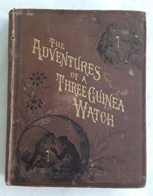
Book, Talbot Baines Reed, The Adventures of a Three Guinea Watch, c 1883
A vintage early 1800's adventure story for teenage boys with black lined illustrations. A boy is given a watch for his 13th birthday as he goes off to school. The watch narrates his own story as he changes 'owners' and travels to London, a pawn shop, a university, to the seaside, India and back to..... There are strong religious themes throughout.A vintage early 1800's brown hardcover children's book with the title The Adventures of a Three Guinea Watch printed in gold diagonal letter on the front cover with a black lined illustration of two boys playing with a fob watch sitting inside a large barrel. The spine has the title and RTS symbol for the publisher printed in gold lettering. The back cover has a black lined drawing of a boy reading a book in front of a bookcase with the heading: THE BOYS OWN BOOKSHELF printed in a banner above. There are flowers and butterflies too. The frontispiece illustration depicts a woman and a man with a boy in football clothes talking. It is covered with faded tissue paper. The title page has the title, author, publisher details and the same black lined illustration as is featured on the back cover. Throughout the book are many black lined illustrations. At the back is page of further Books for Boys published by The Religious Tract Society. The author,Talbot Baines Reed wrote school stories for boys. Pp. 226.fictionA vintage early 1800's adventure story for teenage boys with black lined illustrations. A boy is given a watch for his 13th birthday as he goes off to school. The watch narrates his own story as he changes 'owners' and travels to London, a pawn shop, a university, to the seaside, India and back to..... There are strong religious themes throughout.children's books, books, children's stories, adventure stories, teenage stories, boys' stories