Showing 697 items matching "location map"
-
 Marysville & District Historical Society
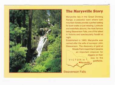
Postcard (item) - Colour postcard, Neil Cutts, The Marysville Story-Steavenson Falls, Pre 2009
... On the front of the postcard is a short story of Marysville as well as a map of Victoria with the location of Marysville depicted with a red dot....On the front of the postcard is a short story of Marysville as well as a map of Victoria with the location of Marysville depicted with a red dot. ...A postcard in a series produced by the Rose Stereograph Company in Victoria, Australia as a souvenir of Marysville.A colour photograph of Steavenson Falls in Marysville, Victoria. The Steavenson Falls is named after the Victorian Assistant Commissioner of Roads and Bridges, John Steavenson, who arrived in Victoria in the early 1860s. At 84 metres high, Steavenson Falls is Victoria's tallest cascading waterfall. The falls are split into roughly five cascades, with the last of these plunging into a small, picturesque rock pool. The Rose Series postcard No. 3530. The Marysville Story/ Marysville lies in the Great Dividing/ Range, a peaceful town where lush/ mountain forests provide a perfect setting/ for bush walks or just relaxing. Lookouts/ and waterfalls abound, the most famous/ being Steavenson Falls, one of the tallest/ in Victoria and spectacularly floodlit at/ night./ Established in 1863, Marysville was/ named after the wife of surveyor John/ Steavenson. The discovery of gold at/ Woods Point meant that it became/ an important stopover for/ diggers on their/ way to the/ goldfields. Steavenson Falls POST CARD The "Rose" Series/ De Luxe Proudly Printed in/ Australia Since 1880 AFFIX/ STAMP/HERE/ Rose Series/ Post Card No./ 3530 ADDRESS/ POSTCODE the MARYSVILLE STORY & Steavenson Falls/ MARYSVILLE, VICTORIA, AUSTRALIA/ Photo Neil Cutts Copyright Rose Stereograph Co., Glen Waverley, Victoria (03) 9560 7772marysville, steavenson falls, victoria, postcard, souvenir, rose stereograph co, 3530, john steavenson -
 Marysville & District Historical Society
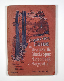
Book, The Atlas Press, Companion Guide to Healesville, Blacks' Spur, Narbethong & Marysville, 1904
... The book contains 65 photographs and information relating to the locations listed on the front cover. There is a pull-out map located on the inside of the back cover. ...map. Paperback. Front cover has a drawing of a countryside outlook. The book contains 65 photographs and information relating to the locations listed on the front cover. ...A companion guide to Healesville, Blacks' Spur, Narbethong & Marysville. With photographs, information and a pull-out map.Paperback. Front cover has a drawing of a countryside outlook. The book contains 65 photographs and information relating to the locations listed on the front cover. There is a pull-out map located on the inside of the back cover. Back cover has details of the rail and coach services available to travel to the destinations mentioned in the book. non-fictionA companion guide to Healesville, Blacks' Spur, Narbethong & Marysville. With photographs, information and a pull-out map.healesville, black spur, narbethong, marysville, victoria, history -
 Marysville & District Historical Society
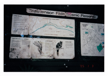
Photograph (item) - Colour photograph, 03-01-2005
... Shows a map of the reserve, information panels on the mountain forest, the lyrebirds and the bobucks (mountain brushtail possums that are all native to the area and a map showing the location of the falls. On the front of the photograph is the date the photograph was taken....Shows a map of the reserve, information panels on the mountain forest, the lyrebirds and the bobucks (mountain brushtail possums that are all native to the area and a map showing the location of the falls. On the front of the photograph is the date the photograph was taken. ...Shows the sign at the Steavenson Falls Scenic Reserve.Shows the sign at the Steavenson Falls Scenic Reserve. This sign was destroyed in the 2009 Black Saturday bushfires. The Steavenson Falls is named after the Victorian Assistant Commissioner of Roads and Bridges, John Steavenson who arrived in Victoria in the early 1860s.'05 1 3 3.01.05. Marysville (from Helga Walsh)steavenson falls, steavenson falls scenic reserve, mountain forest, lyrebird, bobuck, mountain brushtail possum, marysville, victoria, john steavenson, 2009 black saturday bushfires -
 Marysville & District Historical Society
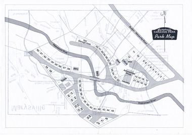
Map (Item) - Marysville Caravan Park map, Marysville CARAVAN PARK-Park Map, Unknown
... A map of the Marysville Caravan Park showing the location of the various sites and facilities available to guests....A map of the Marysville Caravan Park showing the location of the various sites and facilities available to guests....A map of the Marysville Caravan Park showing the location of the various sites and facilities available to guests. marysville victoria australia marysville caravan park map A map of the Marysville Caravan Park showing the location of the various sites and facilities available to guests. ...A map of the Marysville Caravan Park showing the location of the various sites and facilities available to guests.A map of the Marysville Caravan Park showing the location of the various sites and facilities available to guests.marysville, victoria, australia, marysville caravan park, map -
 Marysville & District Historical Society
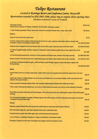
Ephemera (item) - Dinner menu, Tulips Restaurant, Unknown
... On the reverse of the menu is a small town map showing the location of the restaurant....On the reverse of the menu is a small town map showing the location of the restaurant. The menu has also been laminated....On the reverse of the menu is a small town map showing the location of the restaurant. The menu has also been laminated. ...A dinner menu from Tulips Restaurant which was located in Kooringa Resort and Conference Centre in Marysville. On the reverse of the menu is a small town map showing the location of the restaurant.A dinner menu from Tulips Restaurant which was located in Kooringa Resort and Conference Centre in Marysville.marysville, victoria, australia, kooringa, frederick webb, cuzens brothers, betha wilhelmina christina unmack, minnie webb, t.e. foster, edgar charles webb, clarence thomas pitman, jacob pitman, sir isaac pitman, caroline anna blood newenham, henry newenham pitman, carrie rosalind persse pitman, reginald william stringer, alice burton pitman, clarence edward pitman, newenham mueller pitman, olive birch, constance may pitman, olive dora blakeney pitman, gwendoline de burch pitman, kooringa guesthouse, lilian may shelton, thomas henry branchflower, wilbur anderson, peter mackey, caroline anna pitman, joyce anderson, barry brenton, kathy brenton, kooringa tourist house, photograph, kooringa conference centre, kooringa resort and conference centre -
 Marysville & District Historical Society
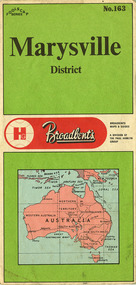
Ephemera (Item) - Tourist map, The Paul Hamlyn Group, Marysville District No. 163, 1950s
... Has a legend, scale and a town map of Marysville. Has an index of locations and their grid details. ...Has a legend, scale and a town map of Marysville. Has an index of locations and their grid details. ...A tourist map of Marysville and the district which was produced by Broadbent's, a division of The Paul Hamlyn Group. Drawn map of Marysville and the district. Has a legend, scale and a town map of Marysville. Has an index of locations and their grid details. Gives details of addresses in New South Wales and Victoria for The Paul Hamlyn Group.A tourist map of Marysville and the district which was produced by Broadbent's, a division of The Paul Hamlyn Group.marysville, victoria, maps, broadbent's, the paul hamlyn group -
 Marysville & District Historical Society
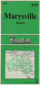
Ephemera (Item) - Tourist map, Lansdowne Press, Marysville District No. 163, Unknown
... Has a legend, scale, and a town map of Marysville. Has an index of locations and their grid details. ...Has a legend, scale, and a town map of Marysville. Has an index of locations and their grid details. ...A tourist map of Marysville and the district which was produced by Broadbent's, a division of Lansdowne Press. Drawn map of Marysville and the district. Has a legend, scale, and a town map of Marysville. Has an index of locations and their grid details. Shows a list of other maps in the Robinson's and Broadbent's range.A tourist map of Marysville and the district which was produced by Broadbent's, a division of Lansdowne Press.marysville, victoria, maps, broadbent's, lansdowne press -
 Victorian Railway History Library
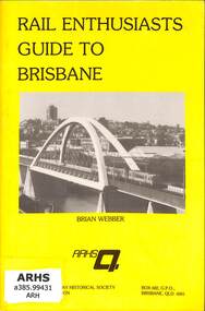
Book, Webber, Brian, Rail Enthusiasts Guide to Brisbane, 1986
... Victorian Railway History Library 39 St Edmonds Rd Prahran Prahran Railroad operations - Queensland - history Railroads - Queensland - history A guide to railway locations for railway enthusiasts visiting Brisbane in Queensland. ill, maps, p.52. ...A guide to railway locations for railway enthusiasts visiting Brisbane in Queensland.ill, maps, p.52.non-fictionA guide to railway locations for railway enthusiasts visiting Brisbane in Queensland.railroad operations - queensland - history, railroads - queensland - history -
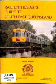 Victorian Railway History Library
Book, Webber, Brian, Rail Enthusiasts Guide to South East Brisbane, 1994
... Victorian Railway History Library 39 St Edmonds Rd Prahran Prahran Railroad operations - Queensland - history Railroads - Queensland - history A guide to railway locations for railway enthusiasts visiting the south eastern suburbs of Brisbane & the Gold Coast in Queensland. ill, maps, p.80. ...A guide to railway locations for railway enthusiasts visiting the south eastern suburbs of Brisbane & the Gold Coast in Queensland.ill, maps, p.80.non-fictionA guide to railway locations for railway enthusiasts visiting the south eastern suburbs of Brisbane & the Gold Coast in Queensland.railroad operations - queensland - history, railroads - queensland - history -
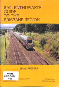 Victorian Railway History Library
Book, Webber, Brian, Rail Enthusiasts Guide to the Brisbane Region, 1999
... Victorian Railway History Library 39 St Edmonds Rd Prahran Prahran Railroad operations - Queensland - history Railroads - Queensland - history A guide to railway locations for railway enthusiasts visiting the Brisbane region in Queensland. ill, maps, p.88. ...A guide to railway locations for railway enthusiasts visiting the Brisbane region in Queensland.ill, maps, p.88.non-fictionA guide to railway locations for railway enthusiasts visiting the Brisbane region in Queensland.railroad operations - queensland - history, railroads - queensland - history -
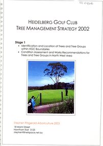 Heidelberg Golf Club
Document - Report, Stephen Fitzgerald Arboriculture, Tree management strategy 2002: Stage 1, 2002=2003
... location of trees and tree groups within HGC boundaries and condition assessment and works recommendations for trees and tree groups in North West area. By Stephen Fitzgerald Arboriculture (Hawthorn East). Includes 3 inserts dated 2024 of plant lists, Banyule planting schemes and significant tree registers. Heidelberg Golf Club - History Course Layout Tree planting Trees Various paging, maps ...Stage 1 deals with identification and location of trees and tree groups within HGC boundaries and condition assessment and works recommendations for trees and tree groups in North West area. By Stephen Fitzgerald Arboriculture (Hawthorn East). Includes 3 inserts dated 2024 of plant lists, Banyule planting schemes and significant tree registers.Various paging, maps, illus. Clear cover, metal spiral binding. heidelberg golf club - history, course layout, tree planting, trees -
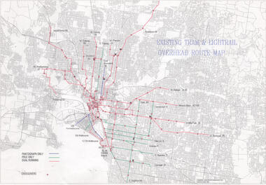 Melbourne Tram Museum
Drawing, Public Transport Corporation (PTC), "Existing tram & Light rail overhead route map", 1996
... location of cross overs, and track availability of pantograph only, pole only and dual running. Dated 5/6/1996 Demonstrates a PTC document for detailing overhead availability and cross overs. tramways PTC Pantographs Trolley Poles overhead cross overs route numbers tram routes Drawing - Document - folded A3 sheet "Existing tram & Light rail overhead route map" Drawing Public Transport Corporation (PTC) ...Drawings shows on a street plan of Melbourne, tram routes, route numbers location of cross overs, and track availability of pantograph only, pole only and dual running. Dated 5/6/1996Demonstrates a PTC document for detailing overhead availability and cross overs.Drawing - Document - folded A3 sheettramways, ptc, pantographs, trolley poles, overhead, cross overs, route numbers, tram routes -
 Melbourne Tram Museum
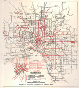
Map, "Tramway Map of Melbourne and Suburbs", c1950
... Map of Melbourne's Tram and Bus routes, route destinations, all-night bus routes, depots, golf links and sporting grounds, rail lines, and location of major places of interest. ...Melbourne Tram Museum 8 Wallen Road Hawthorn melbourne Map of Melbourne's Tram and Bus routes, route destinations, all-night bus routes, depots, golf links and sporting grounds, rail lines, and location of major places of interest. ...Map of Melbourne's Tram and Bus routes, route destinations, all-night bus routes, depots, golf links and sporting grounds, rail lines, and location of major places of interest. Titled - "Tramway Map of Melbourne and Suburbs" - c1950, after the La Trobe or Latrobe St lines opened. Not known who produced the map. Does not give route numbers. See also Reg Item 2300 for an MMTB Map of the same era, 3720 for a similar version with the MMTB guest houses shown, and 4525.1 for an MMTB Photograph.Yields information about Melbourne tram routes prior to Bourke St being built.Fold out map (6 sections), two colours. Has been removed from a book with the remnants of other paper in the top left-hand side.has "1950" in top left hand corner in ink.trams, tramways, melbourne, map, tram & bus services, all night services, mmtb -
 Melbourne Tram Museum
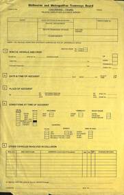
Document, Melbourne & Metropolitan Tramways Board (MMTB), "Traffic employees accident report - Collisions trams", c1975
... Form used by the MMTB traffic staff to report accidents, provide information, details of the event, conditions, damage, names of those involved, cause of the collision, map or drawing of the location, witness details and sobriety of the people involved. ...Melbourne Tram Museum 8 Wallen Road Hawthorn melbourne Form used by the MMTB traffic staff to report accidents, provide information, details of the event, conditions, damage, names of those involved, cause of the collision, map or drawing of the location, witness details and sobriety of the people involved. ...Form used by the MMTB traffic staff to report accidents, provide information, details of the event, conditions, damage, names of those involved, cause of the collision, map or drawing of the location, witness details and sobriety of the people involved. Has a drawing of both W and Z class trams - form 3/396Demonstrates an accident report form used by the MMTB c1975Form - four foolscap pages printed on yellow paper and stapled in top left hand corner.trams, tramways, mmtb, accidents, forms, collisions -
 Melbourne Tram Museum
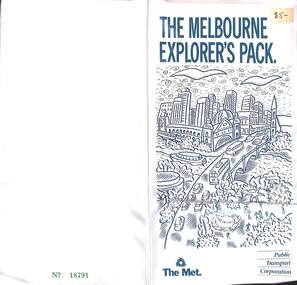
Document - Folder, Public Transport Corporation (PTC), "The Melbourne Explorer's Pack", c1992
... Contains 1 - 12 fold "The Met's Melbourne Explorer's Map" with a map of the CBD, train, tram light rail networks and points of interest and locations. ...Contains 1 - 12 fold "The Met's Melbourne Explorer's Map" with a map of the CBD, train, tram light rail networks and points of interest and locations. ...Plastic folder, white plastic containing clear plastic partitions on the inside. Titled "The Melbourne Explorer's Pack", with The Met and PTC badges. Contains 1 - 12 fold "The Met's Melbourne Explorer's Map" with a map of the CBD, train, tram light rail networks and points of interest and locations. Includes a note on the Bus Network and routes. Folds to 167H x 95W 2 - Book - 48 pages + light card cover, "The Explorers Guide to Melbourne" - has a table of contents and index - details of Melbourne, what to see etc. 165H x 96W .3 - ticket - white card, punched for Nov 6, number EP6362 - has conditions of travel on the rear. 60H x 91W Available for zone 1 only .4 - 3 fold DL, advertising the Explorers Pass - three separate tickets, enabled the purchaser to pick the days. $12. .5 - single DL card as for .4, price $13, dated 1/1/1993. On the front is a hand written price label $5-, indicating that it had been purchased after use.trams, tramways, tickets, all lines tickets, passes, melbourne, the met, ptc -
 Melbourne Tram Museum
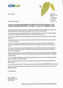
Letter, Yarra Trams, "Tram track renewal and tram stop upgrade works", 1/06/2012 12:00:00 AM
... Gives timetable for works, access arrangements for the apartments and the tram depot. Has a map showing work locations. Dated 18/6 and 22/6/2012, signed by John Uiterwijk, Manager Renewals Yarra Trams....Gives timetable for works, access arrangements for the apartments and the tram depot. Has a map showing work locations. Dated 18/6 and 22/6/2012, signed by John Uiterwijk, Manager Renewals Yarra Trams. ...Set of two A4 sheets, printed both sides, titled "Tram track renewal and tram stop upgrade works", for the reconstruction of the intersection of Power Street, Wallen Road and Riversdale Rd.", Saturday 30/6 to 5/7/2012. Work included the construction of the platform stop, relocation of the cross over from Riversdale Rd to Wallen Road and the reconstruction of the track into the Hawthorn depot. Gives timetable for works, access arrangements for the apartments and the tram depot. Has a map showing work locations. Dated 18/6 and 22/6/2012, signed by John Uiterwijk, Manager Renewals Yarra Trams.trams, tramways, yarra trams, trackwork, wallen rd, riversdale road, riversdale junction, power st, hawthorn depot -
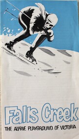 Falls Creek Historical Society
Booklet - Falls Creek THE ALPINE PLAYGROUND OF VICTORIA
... The leaflet information about the size and location of Falls Creek including names of several lodges and a map of the Tourist Village on the back cover....The leaflet information about the size and location of Falls Creek including names of several lodges and a map of the Tourist Village on the back cover. ...This publication was released by the Falls Creek Tourist Area Management Committee during the 1969 snow season. It followed decisions to expand the accommodation and services to approximately double its size at that time. It was aimed at promoting the Resort in an effort to attract further interest and potential investment in this development.This brochure is significant because it documents the manner in which the Tourist Resort was prompted for investors.A fold out brochure with a skier on the front cover. The leaflet information about the size and location of Falls Creek including names of several lodges and a map of the Tourist Village on the back cover.Front cover: Falls Creek THE ALPINE PLAYGROUND OF VICTORIAfalls creek tourist resort, falls creek development, falls creek promotion -
 Sunshine and District Historical Society Incorporated
Photograph - Kealba Photographs 2020, John Alchin, 2020
... The location of the photos is bounded by Rowan Drive, Stensons Road, Green Gully Road and the Maribyrnong River. A map...The location of the photos is bounded by Rowan Drive, Stensons Road, Green Gully Road and the Maribyrnong River. A map ...These photographs provide unique images of the remains of the original boundary / fence lines of some of the early Keilor Commons (Now Kealba) land holders photographed in 2020. The location of the photos is bounded by Rowan Drive, Stensons Road, Green Gully Road and the Maribyrnong River. A map is provided to provide the boundary lines and property owners' names.This photograph collection documents Kealba in 2020.5642.01 - Kealba 2020 Photographs.jpg 5642.02 - D. Donnelly Property Photo 01.JPG 5642.03 - Fence Line Between C. Stenson And Government Rd Photo 01.JPG 5642.04 - Fence Line Between C. Stenson And Government Rd Photo 02.JPG 5642.05 - Fence Line Between C. Stenson And Government Rd Photo 03.JPG 5642.06 - Fence Line Between C. Stenson And Government Rd Photo 04.JPG 5642.07 - Fence Line Between C. Stenson And Government Rd Photo 06.JPG 5642.08 - Fence Line Between D. Donnelly And E. Cahill Photo 01.JPG 5642.09 - Fence Line Between D. Donnelly And E. Cahill Photo 03.JPG 5642.10 - Fence Line Between D. Donnelly And E. Cahill Photo 06.JPG 5642.11 - Fence Line Between D. Donnelly And E. Cahill Photo 07.JPG 5642.12 - Fence Line Between D. Donnelly And E. Cahill Photo 09.JPG 5642.13 - Fence Line Between E. Cahill And Maribyrnong River Photo 01.JPG 5642.14 - Fence Line Between E. Cahill And Maribyrnong River Photo 03.JPG 5642.15 - Fence Line Between E. Cahill And Maribyrnong River Photo 05.JPG 5642.16 - Fence Line Between E. Cahill And Maribyrnong River Photo 06.JPG 5642.17 - Fence Line Between E. Cahill, P. Donnelly And Maribyrnong River Photo 01.JPG 5642.18 - Fence Line Between E. Cahill, P. Donnelly And Maribyrnong River Photo 03.JPG 5642.19 - Fence Line Between E. Cahill, P. Donnelly And Maribyrnong River Photo 05.JPG 5642.20 - Fence Line Between M. Fox And Government Rd Photo 01.JPG 5642.21 - Fence Line Between M. Fox And Government Rd Photo 03.JPG 5642.22 - Fence Line Between M. Fox And Government Rd Photo 05.JPG 5642.23 - Fence Line Between P. McShane And E. Cahill Photo 01.JPG 5642.24 - Fence Line Between P. McShane And E. Cahill Photo 03.JPG 5642.25 - Fence Line Between P. McShane And E. Cahill Photo 05.JPG 5642.26 - Fence Line Between W. Sydenham And Stenson Rd Drain Photo 01.JPG 5642.27 - Fence Line Between W. Sydenham And Stenson Rd Drain Photo 02.JPG 5642.28 - Fence Line North Side P. McShane Photo 01.JPG 5642.29 - Fence Line North Side P. McShane Photo 03.JPG 5642.30 - Fence Line North Side P. McShane Photo 05.JPG 5642.31 - Stenson Rd Drain Photo 02.JPG 5642.32 - Stenson Rd Swimming Hole Photo 01.JPG 5642.33 - W. Sydenham Property Photo 01.JPG kealba, keilor commons -
 Sunshine and District Historical Society Incorporated
Map - City of Sunshine Maps
... Collection of City of Sunshine Maps 160 ft to 1 inch Maps showing streets, lots & lot numbers including location of some of the larger factories. ...City of Sunshine Map City of Sunshine Maps 160 ft to 1 inch Maps Collection of City of Sunshine Maps 160 ft to 1 inch Maps showing streets, lots & lot numbers including location of some of the larger factories. ...City of Sunshine Maps 160 ft to 1 inch Mapscity of sunshine, map -
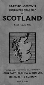 Sunshine and District Historical Society Incorporated
Map - Bartholomew's Contoured Road Map of Scotland
... Handwritten text and arrowed line in pencil indicating location of where "Coldstream" is on the map....Scotland Map Handwritten text and arrowed line in pencil indicating location of where "Coldstream" is on the map. ...Handwritten text and arrowed line in pencil indicating location of where "Coldstream" is on the map.scotland, map -
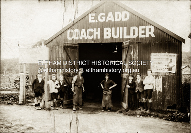 Eltham District Historical Society Inc
Photograph, E. Gadd Coach Builder, Eltham, c. March 1930
... location for the blacksmith shop, being a coach builder, would be near or on the main road. The only area in Eltham relative to other businesses that has a flattish topography with hills in the distant is around the railway station. E. Gadd’s Blacksmith shop was situated on the western side of Main Road, between Arthur and Dudley Streets and does appear to be visible in the 1931 aerial photo held by the Society. A map...location for the blacksmith shop, being a coach builder, would be near or on the main road. The only area in Eltham relative to other businesses that has a flattish topography with hills in the distant is around the railway station. E. Gadd’s Blacksmith shop was situated on the western side of Main Road, between Arthur and Dudley Streets and does appear to be visible in the 1931 aerial photo held by the Society. A map ...Note with photo: "Man with hammer is Mr Gadd; always wore leggings and played violin at local dances. On his left is Harold Norman of Research. (Sam Howard played banjo). Mrs Read (Jock's mother) played piano by ear. Research called Normantown because no one could remember who was related to who." Note the school children; one of whom may be Jock Read. In April 1922, E.Gadd took over the West Bros. blacksmithing business at Eltham. He had many prior years’ experiences with horses and their ailments, such as diseased feet and bad breath. He advertised that he kept horse medicines in stock and was prepared to undertake clipping. [THE Eltham and Whittlesea Shires Advertiser AND Diamond Creek Valley Advocate. (1922, April 7). Eltham and Whittlesea Shires Advertiser and Diamond Creek Valley Advocate (Vic. : 1917 - 1922), p. 3 (AFTERNOON.). Retrieved July 31, 2025, from http://nla.gov.au/nla.news-article57640818] A poster on the exterior wall of the shed promotes protection of vineyards from Prohibition by voting No. This would date this photo around March 1930. A vote was being held by the Victorian government which the vineyard growers were opposed to due to the ramifications it would have upon the wider industry for dried fruits and table grapes, etc as well and how it was in direct conflict with the federal government's actions of WW1 Soldiers Settlements on vineyards as it would ruin them. [HOW VINE GROWERS WOULD BE PENALISED (1930, March 28). Advertiser (Hurstbridge, Vic. : 1922 - 1939), p. 4 (AFTERNOON). Retrieved July 31, 2025, from http://nla.gov.au/nla.news-article57762063] Edward Gadd died of pneumonia, July 1937. He had operated his coach building business in Eltham for about 17 years (1920-1937). He lived in Research and left a wife and three sons. He was actively involved with the Research Hall and was largely instrumental in its establishment. [Death of Mr. Edward Gadd. (1937, July 23). Advertiser (Hurstbridge, Vic. : 1922 - 1939), p. 1. Retrieved July 31, 2025, from http://nla.gov.au/nla.news-article56845399] Following Gadd’s death, P. Sloan of Warrandyte took over the business, which he advertised as 'Eltham Shoeing Forge'. [Advertising (1937, July 30). Advertiser (Hurstbridge, Vic. : 1922 - 1939), p. 6. Retrieved July 31, 2025, from http://nla.gov.au/nla.news-article56845470] The photo was taken around March 1930 and Gadd operated his business between 1922 and 1937. This would suggest the shed would be visible in the November 1931 aerial photograph. Looking past the shed to the left the topography is relatively flat. The most probable location for the blacksmith shop, being a coach builder, would be near or on the main road. The only area in Eltham relative to other businesses that has a flattish topography with hills in the distant is around the railway station. E. Gadd’s Blacksmith shop was situated on the western side of Main Road, between Arthur and Dudley Streets and does appear to be visible in the 1931 aerial photo held by the Society. A map drawn up by Doug Orford of businesses and homes along Main Road in the 1930s shows the Gadd blacksmith shop in this precise location, just south of Staff’s general store. (See EDHS_05122). Other photos show the blacksmith shop adjacent to the Railway store and it had “Electrine Candles” advertising painted on the roof facing the southern approach along Main Road (SEPP_0611) and is just visible to the left of Lloyd’s Store c.1916-c.1922 (EDHS_02160). The rear of the shop facing the railway line is visible in EDHS_05593 Panorama at Eltham c. 1925. Sepia photographcoaches, dance band, edward gadd, eltham, harold norman, jock read, mrs read, prohibition vote, research (vic.), sam howard, vineyards, industry, school children -
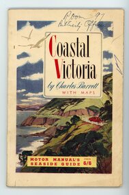 Orbost & District Historical Society
Booklet - Coastal Victoria, Charles Barrett, c.1950s
... Back cover has a map of Victoria shown in a reddish colour with roads and locations marked on it. ...Back cover has a map of Victoria shown in a reddish colour with roads and locations marked on it. ...This Motor Manual for Coastal Victoria is c.1950s and represents a must-have for the growing population of motoring public in Australia after World War II.This booklet is significant because it relates to the growing population of Australians with cars following World War II, people who were keen to explore Victoria. A booklet of 106 pages. Front cover has a coloured illustration of a red car driving around hills with the ocean below on the left hand side. Back cover has a map of Victoria shown in a reddish colour with roads and locations marked on it. Coastal Victoria by Charles Barrett with maps MOTOR MANUAL'S SEASIDE GUIDE price 6/6motoring, tourism, coastal victoria -
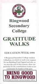 Ringwood and District Historical Society
Pamphlet, Ringwood Secondary College - Gratitude Walks- Education Week 1999
... .-------- The rear of this pamphlet is largely a map of the locations of the people honoured on the Gratitude Walks.....-------- The rear of this pamphlet is largely a map of the locations of the people honoured on the Gratitude Walks. ...Red, Pink, Green and White coloured multi-fold gloss publication- six small pages and one large image on the rear of all of the small pagesThis publication deals with a Ringwood Secondary College Walkathon, in which they sought support for their Building Fund Appeal, and also wished to show their gratitude for the contribution made to the Ringwood community by leaders of the past. The notable locations and people written about are arranged alphabetically. They are - Dexters Bush (Mick and Liz Dexter), Harpers Bush (John and Joan Harper), A.F.B. Long Reserve (Arthur Frederick Burbridge Long), McAlpin Reserve (George McAlpin and family Reserve), Fred Dwerryhouse Pool, B.J.Hubbard (Ben) Reserve, Loughies Bushland (named after Anthony Loughnan- early settler), Douglas Maggs Reserve, Greenwood Park (named after Edmund Wilson Greenwood (local MLA from 1927 to 1929), A.G. Lavis Pavilion (Albert George Lavis - Mayor and Councillor), Russell Lucas Oval (situated at Jubilee Park), Mahon Reserve (Hugh and his son Arthur Mahon - apple and Cherry orchardists), H.E. Parker Reserve (Henry Ernest Parker), Herman Pump Reserve, F.J.C. Rogers Reserve (Fred), Staley Gardens (named after Andrew Gray Staley), Kevin Pratt Pavilion (at Jubilee Park), A.C. Robertson Field (Alan Robertson - Proclamation Park), R.O. Spencer Pavilion (Reginald Owen Spencer), Peter Vergers Reserve.-------- The rear of this pamphlet is largely a map of the locations of the people honoured on the Gratitude Walks. -
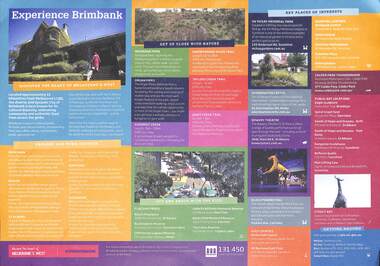 Sunshine and District Historical Society Incorporated
Poster - Experience Brimbank Poster
... Derrimut Golf Club, Brimbank Cente Shopping Centre, Keilor Central Shopping Centre, Sunshine Marketplace Shopping Centre, Sunshine Plaza Shopping Centre, Watergardens Shopping Centre, Clader Park Thunderdome|Public Art locations - Eagle sculpture Federation Trail Brooklyn, Spiral Graph Seat Lennon Parkway Derrimut, Seeds of Hope and Dreams Drift Alfredia St, Seeds of Hope and Dreams Yam Daisy St. Albans Square, Kangaroo Sculpture Matthews Hill, Reflexio Qualis sculptures Sunshine Bus Interchange and City Place, Man Lifting Cow Hampshire Rd Two sided poster with map of Brimbank on front and detailed description of key places of interest on back Poster Experience Brimbank Poster ...Poster produced by the City of BrimbankExperience Brimbank|Explore town centres of Deer Park, Keilor, St. Albans, Sunshine & Sydenham|Get up close with nature - Brimbank Park, Maribyrnong River Trail, Organ Pipes, Taylors Creek Trail, Kororoit Creek & Jones Creek Trail|Out and about with the kids - Alice's Playspace, Buckingham Reserve, Cliff Harvey Lagoon Reserve, Isabella Williams Memorial Reserve, Kevin Flint Memorial Reserve & The Lakes Reserve|Key places of interest - H.V. McKay Memorial Park, Overnewton Castle, Bowery Theatre, Black Powder Mill, Keilor Golf Course, Mt. Derrimut Golf Club, Brimbank Cente Shopping Centre, Keilor Central Shopping Centre, Sunshine Marketplace Shopping Centre, Sunshine Plaza Shopping Centre, Watergardens Shopping Centre, Clader Park Thunderdome|Public Art locations - Eagle sculpture Federation Trail Brooklyn, Spiral Graph Seat Lennon Parkway Derrimut, Seeds of Hope and Dreams Drift Alfredia St, Seeds of Hope and Dreams Yam Daisy St. Albans Square, Kangaroo Sculpture Matthews Hill, Reflexio Qualis sculptures Sunshine Bus Interchange and City Place, Man Lifting Cow Hampshire Rdbrimbank -
 Sunshine and District Historical Society Incorporated
Map - City of Sunshine Maps C1976
... Collection of rolled up maps showing street names and other locations of interest in the former City of Sunshine C1976...City of Sunshine Map City of Sunshine Maps C1976 Collection of rolled up maps showing street names and other locations of interest in the former City of Sunshine C1976 Map City of Sunshine Maps C1976 ...City of Sunshine Maps C1976city of sunshine, map -
 Sunshine and District Historical Society Incorporated
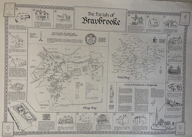
Map - The Parish of Braybrooke Map
... Large white map that lists the locations of multiple buildings within the Parish of Braybrooke...Braybrook Map The Parish of Braybrooke|Church|Wantage Farm|The Old Sun Inn|The Bridge & Bridge House|Baptist Chapel & Bowden Bridge|Castle Farm|Braybrooke Castle|Probable Site of Braybrooke Orange|Workhouse Row and Jubilee Tree|The Old Post Office|Green Lane Cottage|Old Parish Houses|Bleak House|Old Village Store and Club House|Jim Robinson's Cottage|The Old School|The Swan Inn|Mrs Underwood's House|The Old Rectory|Village Hall|Braybrooke Primary School Large white map that lists the locations of multiple buildings within the Parish of Braybrooke Map The Parish of Braybrooke Map ...The Parish of Braybrooke|Church|Wantage Farm|The Old Sun Inn|The Bridge & Bridge House|Baptist Chapel & Bowden Bridge|Castle Farm|Braybrooke Castle|Probable Site of Braybrooke Orange|Workhouse Row and Jubilee Tree|The Old Post Office|Green Lane Cottage|Old Parish Houses|Bleak House|Old Village Store and Club House|Jim Robinson's Cottage|The Old School|The Swan Inn|Mrs Underwood's House|The Old Rectory|Village Hall|Braybrooke Primary Schoolbraybrook, map -
 Sunshine and District Historical Society Incorporated
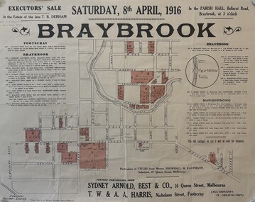
Document - Estate of the late T. B. Derham Land Sale Map, 1916
... Map showing the location and description of the Estate of the late T. ...Derham Saturday 8th April 1916 in the Parish Hall Ballarat Road Braybrook Map showing the location and description of the Estate of the late T. ...Executive sale in the Estate of the late T. B. Derham Saturday 8th April 1916 in the Parish Hall Ballarat Road Braybrookthomas burge derham -
 Williamstown Historical Society Inc
Book - Book - Community of Believers. Westbourne Grammar School, 1867 - 2017, Bounce Books, Community of Believers. Westbourne Grammar School, 1867 - 2017, 2017
... It documents the school's journey from Williamstown to its current location. 271 pages : illustrations (some colour), maps (some folded), portraits (some colour), photographs (some colour) Community of Believers. ...Community of Believers: Westbourne Grammar School 1867-2017 is a 271-page history book celebrating the school's 150th anniversary, published by Bounce Books in 2017. It documents the school's journey from Williamstown to its current location.271 pages : illustrations (some colour), maps (some folded), portraits (some colour), photographs (some colour) non-fictionCommunity of Believers: Westbourne Grammar School 1867-2017 is a 271-page history book celebrating the school's 150th anniversary, published by Bounce Books in 2017. It documents the school's journey from Williamstown to its current location.westbourne grammar school, schools, private schools, truganina, williamstown -
 Sunshine and District Historical Society Incorporated
Map - The Aiatsis Map of Indigenous Australia, David R. Horton, 1996
... The Aiatsis Map of Indigenous Australia showing the general locations of larger grouping of people which may include clans, dialects or individual lanuages|Aboriginal...Aborigine Aboriginal First Nation The Aiatsis Map of Indigenous Australia showing the general locations of larger grouping of people which may include clans, dialects or individual lanuages|Aboriginal Large laminated colored map Map The Aiatsis Map of Indigenous Australia David R. ...The Aiatsis Map of Indigenous Australia showing the general locations of larger grouping of people which may include clans, dialects or individual lanuages|Aboriginalaborigine, aboriginal, first nation -
 Sunshine and District Historical Society Incorporated
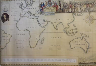
Map - Voyage of the First Fleet Map
... Voyage of the First Fleet Map including dairy entries of the conditions at sea & stop over location...First Fleet Map Voyage of the First Fleet Map including dairy entries of the conditions at sea & stop over location A map showing the route of the First Fleet Map Voyage of the First Fleet Map ...Voyage of the First Fleet Map including dairy entries of the conditions at sea & stop over locationfirst fleet, map