Showing 16883 items matching "plenty-river"
-
 Marysville & District Historical Society
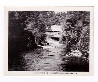
Photograph (item) - Black and white photograph, Murray Views, Murray Views No. 11. Taggerty River, Marysville, Vic, Post 1929
An early black and white photograph of the Steavenson River in Marysville, Victoria.An early black and white photograph of the Steavenson River in Marysville, Victoria. The Steavenson Falls is named after the Victorian Assistant Commissioner of Roads and Bridges, John Steavenson who arrived here in the early 1860s. This photograph was published by Murray Views in Gympie, Queensland, as a souvenir of Marysville.marysville, victoria, photograph, murray views, souvenir, steavenson river, john steavenson -
 Marysville & District Historical Society
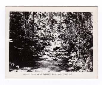
Photograph (item) - Black and white photograph, Murray Views, Murray Views No. 45. Taggerty River, Marysville, Vic, Post 1929
An early black and white photograph of the Taggerty River in Marysville, Victoria. An early black and white photograph of the Taggerty River in Marysville, Victoria. This photograph was produced by Murray Views in Gympie, Queensland as a souvenir of Marysville.taggerty river, marysville, victoria, murray views, photograph, souvenir -
 Marysville & District Historical Society
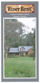
Flyer (item) - Accommodation flyer, 'River Rest', Unknown
An information flyer regarding accommodation at River Rest cottage in Buxton.An information flyer regarding accommodation at River Rest cottage in Buxton.buxton, victoria, australia, river rest country cottage, accommodation, flyer -
 Eltham District Historical Society Inc
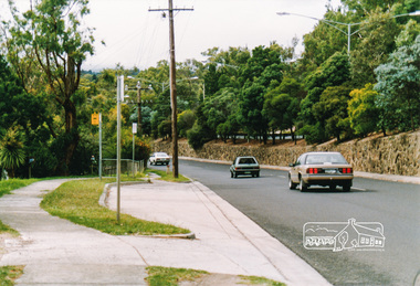
Photograph, Doug Orford, Lower Plenty Bridge, Old Eltham Road, Lower Plenty, 1998
Originally the boundary between the former Shire of Eltham and the City of Heidelberg, a toll gate existed on the Eltham side. The bridge has since been restored and is now part of the Plenty River Trail.Two colour photograph prints 10 x 15 cm (2 copies)bridges, lower plenty, main road, plenty river, old eltham road -
 Orbost & District Historical Society
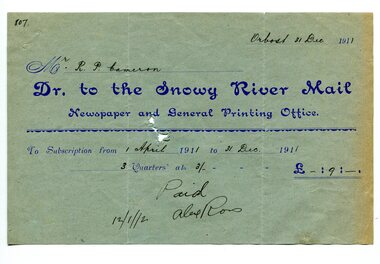
account, 12.12.1912
Previously published as The Snowy River mail and Tambo and Croajingolong gazette from 1890 to 1911. The Gippsland Courier merged with the Snowy River Mail when proprietor Lachlan Ross moved to Orbost in 1910. In 1999 the paper was acquired by the Yeates family when the Hollins family retired from the newspapers business. The paper is still being produced by the fourth generation of the Yeates family as part of East Gippsland Newspapers. They also produce the Bairnsdale Advertiser, the East Gippsland News and the Lakes Post and the yearly publications East Gippsland Visitor Guide and the Great Alpine Road Touring Guide. Robert Pullar Cameron was a Shire Councillor for many years. He married Penuel Hossack and had a family of James, Flora, Penuel and Alex.This item is an example of the early book-keeping of the Snowy River Mail newspaper and is a useful research tool.A light blue paper account with dark blue print from The Snowy River Mail, Newspaper and General Printing to R. Cameron.snowy-river-mail cameron-robert-pullar -
 Orbost & District Historical Society
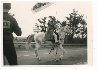
black and white photographs, November 1976
All of these photographs were taken prior to 25th November, 1876, the official opening and crossing of the current Snowy River Bridge. Gary Downey, an Orbost Apeian, did a "De Groot" and crossed the bridge on horseback prior to the official cars crossing the bridge to signal the opening of the new structure. There was a closing ceremony for the old bridge with a group arriving in a 1927 Chrysler, owned by Apexian, Peter Dreverman. This was watched by groups of school students. Some of the Apex members, including Jim Duggan, Noel Smart and Pat Hall, dressed in formal attire to speak to the audience.This event was organised by the Apex Club of Orbost.The Apex Club of Orbost was a volunteer service club which contributed to the Orbost community. A declining population has led to the demise of many social groups in the area.Ten black / white photographs related to the unofficial opening of the Snowy River Bridge at Orbost. snowy-river-bridge-1976 apex-club-orbost ceremony -
 Wodonga & District Historical Society Inc
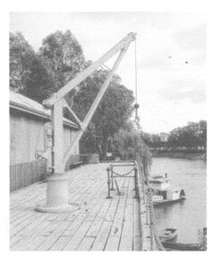
Photograph - The River Port of Red Bank
THE RIVER PORT OF REDBANK During the 1870s, Red Bank would have been one of the busiest ports on the Murray River. When the railway line was being built from Melbourne to Wodonga all the railway material was brought up river from Echuca by paddle steamer and barge and unloaded at Red Bank. The material was loaded onto horse teams or bullock wagons and taken along the route of the spur line. During the 187 MacCulloch & Co. handled 3000 tons of railway material here' The port was operational from approximately 1870 until 1874. THE FIG TREES The fig trees and a small bank of gravel are the only visible reminders of where the spur line from the wharf at Red Bank met the main line. It was at this point that all the material for the mainline was transferred from the small locomotives and wagons from Red Bank. It would have been carried by bullock wagons and horse teams and unloaded at different places as the line progressed. After the line was completed in 1873 the fettlers from Wodonga would patrol this length of the line.These images are significant because they document an important stage in the development of transportation in North East Victoria.Images of the River Port of Red bank near Wodonga on the Murray River. 1. The wharf 2. All that remainsred bank port, historic wharf wodonga, river transport -
 Marysville & District Historical Society
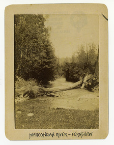
Photograph (Item) - Black and white photograph, Maroondah River - Fernshaw, c1900
An early black and white photograph of the Watts River at Fernshaw. The photograph has been incorrectly labeled as the Maroondah River - Fernshaw.An early black and white photograph of the Watts River at Fernshaw. The photograph has been incorrectly labeled as the Maroondah River - Fernshaw.ARMSTRONG COLLECTION 42 STATION STREET/ SANDRINGHAM 3191/ TEL. (03) 9521 5442/ IAN M.L. ARMSTRONG OAMwatts river, fernshaw, maroondah river, victoria -
 Orbost & District Historical Society
black and white photographs, February 17 1971
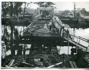
After the damage from the February 1971 floods at Orbost when the abutment to the Snowy River road bridge was washed away a Bailey bridge, portable, pre-fabricated, truss bridge, was put into place to ensure town access, the C.R.B. rebuilt the approach to the bridge driving new piles and constructing the Bailey bridge. They worked late into the night under flood lights to ensure the link from the Orbost township to the Princes Freeway would be open to traffic as soon as possible.These photographs are pictorial records of a significant event in the history of Orbost.Three black / white photographs of a Bailey bridge being erected across a river. 3245.1 and 3245.2 are the same. bailey-bridge orbost-snowy-river-bridge bridge-orbost -
![Waterfall Scene Near the Buchan River / [by] Nicholas Caire, circa 1876](/media/collectors/550653872162f11fb04854aa/items/57825da5d0cdd1176ce3ed3d/item-media/57825e03d0cdd1176ce418cf/item-fit-380x285.jpg) Kew Historical Society Inc
Kew Historical Society IncPhotograph, Anglo-Australasian Photographic Company, Waterfall Scene Near the Buchan River, c. 1876
Nicholas Caire was born on Guernsey in the Channel Islands in 1837. He arrived in Adelaide with his parents in about 1860. In 1867, following photographic journeys in Gippsland, he opened a studio in Adelaide. From 1870 to 1876 he lived and worked in Talbot in Central Victoria. In 1876 he purchased T. F. Chuck's studios in the Royal Arcade Melbourne. In 1885, following the introduction of dry plate photography, he began a series of landscape series, which were commercially successful. As a photographer, he travelled extensively through Victoria, photographing places few of his contemporaries had previously seen. He died in 1918. Reference: Jack Cato, 'Caire, Nicholas John (1837–1918)', Australian Dictionary of Biography.An original, rare photograph from the series 'Views of Victoria: General Series' by the photographer, Nicholas Caire (1837-1918). The series of 60 photographs that comprise the series was issued c. 1876 and reinforced a neo-Romantic view of the Australian landscape to which a growing nationalist movement would respond. Nicholas Caire was active as a photographer in Australia from 1858 until his death in 1918. His vision of the Australian bush and pioneer life had a counterpart in the works of Henry Lawson and other nationalist poets, authors and painters.‘Waterfall scene near the Buchan River’ : Views of Victoria (General Series), No.39 : Albumen silver photograph | Photo on card with Title and Description on reverse | Mounted 24 x 30 cm; Photo 12 x 17 cm.On Reverse: ‘The Buchan River is a tributary of the great Snowy River, which extends itself from Port Ricardo, on the Gipps Land coast, to considerably beyond Mt. Kosciusko, in New South Wales. It is comparatively but a stream, but, like most of the smaller rivers in Victoria, it contains some beautiful scenery, peculiar to itself. Our present illustration is characteristic of its scenery, and is taken from a creek close to the River.’nicholas caire (1837-1918), buchan river, landscape photography - victoria -
 Kew Historical Society Inc
Photograph, Standard Newspapers, Charles Grimes Re-enactment, Yarra River, 1978
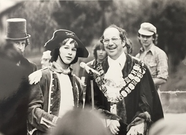
The party of the British surveyor Charles Grimes were the first Europeans to view the River Yarra, as it was later to be named. Members of the party reached the area now known as Studley Park in 1803. This local re-enactment commemorated 175 years since that event. Charles Grimes Re-Enactment, Yarra River, Kew, 1978. The photograph is of a student of Trinity Grammar School and the Mayor of Kew, Cr. Whiting. Inscription on reverse: "KH-161. Society's contribution to the 1978 Festival of Kew. Re-enactment of first white man's journey and discovery of the Yarra River and the area now know (sic) as Kew. 1978. This was in the year 1903 when Grimes and party came upon the Yarra to seek a possible site for a new convict settlement. Cr. Whiting, Mayor of Kew, receiving the report from Grimes, 'Andrew Allen'. Cr. Hutchinson in top hat 'town cryer'. Bush band in backround." Ripped stamp on reverse: "Standard N[ewspapers]."charles grimes re-enactment, trinity grammar school, cr whiting -- mayors -- kew (vic.), yarra river, andrew allen, kew historical society -
 Marysville & District Historical Society
Photograph (Item) - Black and white photograph, Fred Kruger, Scene on the Watts River near Fernshaw, Unknown
A copy of a black and white photograph on the Watts River near Fernshaw in Victoria.A copy of a black and white photograph on the Watts River near Fernshaw in Victoria taken by Fred Kruger. Fred Kruger (born Johan Friedrich Carl Kruger, 18 April 1831 – 15 February 1888) was a German-born photographer noted for his early photography of landscape and indigenous peoples in Victoria, Australia. Fernshaw was a rural township 63 km northeast of Melbourne and 10 km northeast of Healesville. Situated on the Watts River, near where a log had fallen making a convenient crossing, Fernshaw was settled in the 1860s. It provided good country for orchards and berry growing. The location was at the foot of Blacks Spur, with Mounts Juliet and Mondah rising on either side, providing spectacular scenery. There were nearby fern gullies giving rise to the name – ‘shaw’ is old English for thicket or wood. By 1875 Fernshaw had a post office (1865), two hotels, a school (1871), and stores. It was famed for its beauty, attracting tourists. In 1886 the Melbourne and Metropolitan Board of Works began work on the Watts River water catchment scheme – later to become Maroondah – and the Board obtained approval for the catchment country to be reserved and kept free of settlement. This required the removal of the Fernshaw township, which was completed by about 1890.fernshaw, watts river, victoria, fred kruger, photograph -
 Stawell Historical Society Inc
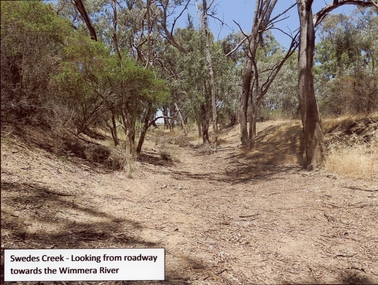
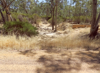
Photograph, Swedes Creek Looking looking towards the Wimmera River 2017 -- Coloured
Colour Photo of Swedes Creek looking from roadway towards the Wimmera River 2017. (Jan)Colour photograph of a dry creek bed. Trees along and around the dry creek.Swedes Creek - Looking from roadway towards the Wimmera River.water -
 Warrnambool and District Historical Society Inc.
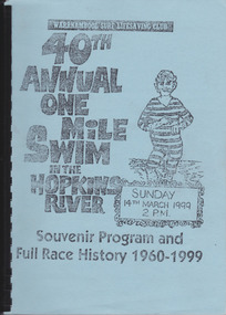
Work on paper - Report, Warrnambool Surf Lifesaving Club, 40th Annual One Mile Swim of the Hopkins River, 1999
The Hopkins River One Mile Swim started in 1960 as part of an Aquatic Day to raise funds for the Warrnambool Olympic Pool. Since 1961 a measured One Mile Course (1600 metres) was used, the course being up river for approx. 286 metres, then to the bridge and back to the jetty to the finishing line. It was a handicap race. The race was abandoned after 46 years (2005). The booklet is of some importance as it gives the details of the Hopkins River One Mile Race, an event that was a prominent one in Warrnambool for 46 years. The booklet records the achievements of the competitors and the work of the committees involved and will be useful for researchers. This is a booklet containing a souvenir program for the 40th Annual One Mile Swim in the Hopkins River in 1999 and a Full Race History from 1960 to 1999. It has been produced in-house by the Warrnambool Surf Lifesaving Club and has a blue cardboard front cover and a grey back cover. The photocopied and typed pages have been bound with black plastic. The contents include newspaper cuttings, photocopies of photographs, lists of winners and a list of the race’s sponsors. There are three loose sheets.Front Cover: Warrnambool Surf Lifesaving Club, 40th Annual One Mile Swim in the Hopkins River, Sunday 14th March 1999, 2 p.m., Souvenir Program and Full Race History 1960-1999warrnambool surf lifesaving club, hopkins river mile swim, hopkins river -
 Greensborough Historical Society
Slide - Photograph, John Ramsdale, Plenty Gorge: Slide 11, 1990s
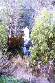
Photograph shows a river through bushland; this is the Plenty Gorge.Part of the John Ramsdale collection of slides and audio visual material.Colour photograph scanned from slide.No maker's marks. No caption on slide.plenty river, plenty gorge metropolitan park -
 Greensborough Historical Society
Slide - Photograph, John Ramsdale, Plenty Gorge: Slide 59, 1990s
Photograph shows a river through bushland. This is in Plenty Gorge.Part of the John Ramsdale collection of slides and audio visual material.Colour photograph scanned from slide.No maker's marks. No caption on slide.plenty gorge, plenty gorge metropolitan park -
 Eltham District Historical Society Inc
Photograph, Main Road, Lower Plenty
Black and white photograph of Main Road, Lower Plenty looking west from Old Eltham Roadlower plenty, main road, old eltham road -
 Eltham District Historical Society Inc
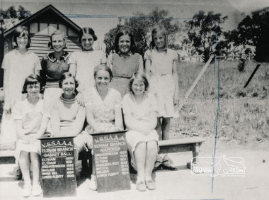
Photograph, Lower Plenty Basketball Team, c.1935, 1935c
Black and white photograph copy of an original image of Lower Plenty Girls Basketball team, c.1935basketball, netball, sports, lower plenty -
 Eltham District Historical Society Inc
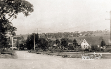
Photograph, Main Road, Lower Plenty
Colour photograph of Main Road, Lower Plenty/Montmorency east of Grand Boulevard looking towards Elthammain road, lower plenty, montmorency -
 Stawell Historical Society Inc
Photograph, Dunmunkle Creek looking towards Wimmera River 2017 -- Coloured
Colour Photo of Dunmunkle Creek looking towards Wimmera River 2017.Colour photograph of dry creek bed surrounded by vegetation. Dunmunkle Cree looking towards Wimmera River from roadway - 2017.water -
 Eltham District Historical Society Inc
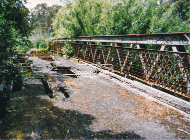
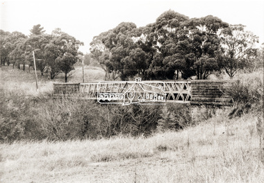
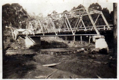
Photograph, Old Lower Plenty Bridge, c.1970
Old bridge across the Plenty River at Lower Plenty now part of the Plenty River Trail. Part of a slide show presentation "Bridges & Waterways of the Shire" by Russell Yeoman to the 13 September 1989 Society meeting. The presentation included slides of historic photos from the Shire of Eltham Pioneers collections as well as several recent views.Black and white photographmain road, plenty river, bridge, lower plenty, plenty river trail -
 Eltham District Historical Society Inc
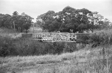
Negative - Photograph, Russell Yeoman, Old Lower Plenty Bridge, c.1970
Old bridge across the Plenty River at Lower Plenty now part of the Plenty River Trail. Part of a slide show presentation "Bridges & Waterways of the Shire" by Russell Yeoman to the 13 September 1989 Society meeting. The presentation included slides of historic photos from the Shire of Eltham Pioneers collections as well as several recent views.Roll of 35mm black and white negative film, 4 of 7 stripsIlford HP4bridge, lower plenty, main road, plenty river, plenty river trail -
 Queenscliffe Maritime Museum
Pamphlet - Clyde River Scotland, Pamphlets, brochures and news article re travelling on the Clyde River Scotland
Clyde River boats ScotlandClyde River boatsColourt & B&W brochures, pamphlets & news article re boats on the Clyde River Scotland.Reverse " NIL "historical references -
 Greensborough Historical Society
Slide - Photograph, John Ramsdale, Plenty Gorge: Slide 106, 1990s
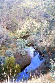
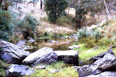
Photograph shows a rocky area near river in Plenty Gorge.Part of the John Ramsdale collection of slides and audio visual material.Colour photograph scanned from slide.No maker's marks. No caption on slide.plenty river, plenty gorge -
 Greensborough Historical Society
Photograph - Digital Image, Pipes over Plenty, construction of original bridge for Watts Reservoir aqueduct, 1950-1970
Photograph of the Maroondah aqueduct bridge over the Plenty River in Greensborough.Digital copy of black and white photograph.maroondah aqueduct, aqueduct, plenty river -
![Advertising Leaflet, John McEwen and Co, Heidelberg Park Estate [Lower Plenty], 1913c](/media/collectors/4f729f5697f83e03086015b8/items/5dcfb52321ea671434e9ca4c/item-media/5dcfb56321ea671434ea0352/item-fit-380x285.jpg) Greensborough Historical Society
Greensborough Historical SocietyAdvertising Leaflet, John McEwen and Co, Heidelberg Park Estate [Lower Plenty], 1913c
Copy of auction leaflet for the sale of land fronting the Plenty River. Known as Heidelberg Park, this land is in what is now Lower Plenty. Sale circa 1913Digital copy of auction leaflet, 1 page.heidelberg park, lower plenty, land sales -
 Eltham District Historical Society Inc
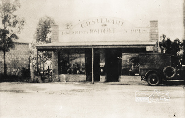
Photograph, C.D. Stewart Lower Plenty Post Office and Store, 1920s
Black and white photograph of post office store, Lower Plenty, C D Stewart proprietor c.1920s.post office, shops, lower plenty, c.d stewart, main road -
 Eltham District Historical Society Inc
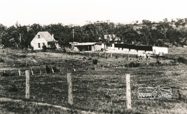
Photograph, De Bondy house, Lower Plenty
Four black and white photograph reproductions showing De Bondy house and property, Main Road, Lower Plentyhouses, main road, lower plenty, de bondy -
 Orbost & District Historical Society
display book, Andrews, Gordon, Foundation and Establishment of the Snowy River Co-op Recollections, September 2006
Snowy River Seeds started life as a farmers' co-operative (Snowy River Co-op) in 1967 specialising in horticulture. Gordon Andrews was the author of the book Snowy River Pioneers.This a documented history of the Snowy River Co-op the original creators of Snowy Seeds.A grey plastic display book containing computer printed pages, copies of newspaper articles and photos. it has been compiled by Gordon Andrews.on label on front cover - Foundation and Establishment of the Snowy River Co-op Recollections by Gordon Andrews, Sept 2006 snowy-river-co-op andrews-gordon -
 Tatura Irrigation & Wartime Camps Museum
Book, The River Murray, 1990
Written to record history of River Murray from aboriginal times, early settlers, riverboats, maps, irrigation, agriculture.Map of Murray River and districts on front cover. 4 river scenes in square boxes. Gold disc, paddle steamer, names of 3 states. Early scenes n back cover. 1 present day.irrigation, books, reference, rural, industry