Showing 25578 items matching "plenty-township-estate"
-
 Eltham District Historical Society Inc
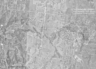
Work on paper (Sub-Item) - Photograph, Diamond Creek from Wattletree Road, Eltham to Diamond Creek township
Black and white aerial view of Diamond Creek from Wattletree Road, Eltham to Diamond Creek Townshipeltham, drain, diamond creek -
 Eltham District Historical Society Inc
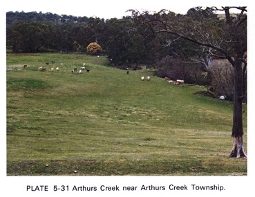
Work on paper (Sub-Item) - Photograph, Arthurs Creek near Arthurs Creek township, 1976
Colour photograph of Arthurs Creek near Arthurs Creek township. Hilly grassed landscape with cattle in the backgroundarthurs creek, cattle, farm -
 Bacchus Marsh & District Historical Society
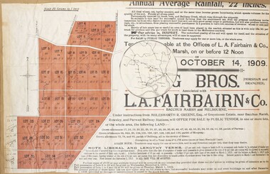
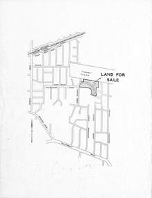
Map, Greystones Estate Land Sale 1909
This map was produced sometime around mid 1909 to advertise portions of land from the Greystones Estate for sale by public tender. The selling agents were Young Brothers of Horsham and L.A. Fairbairn of Bacchus Marsh and Melbourne. The seller was Molesworth R. Greene who was a pioneer pastoralist in the Bacchus Marsh area and had also acquired other properties in Victoria and interstate. Molesworth Greene died in 1916 so this sale came towards the end of his life. A total of 4,176 acres was offered for sale in multiple lots. Successful tenderers could buy single or multiple lots. The results of the sale were reported in the Bacchus Marsh Express newspaper on the 16th October 1909, page 3. At the sale a total of 3, 420 acres was sold. A single page paper map showing portions of land for sale from the Greystones Estate near Bacchus Marsh. The map includes extensive details about the property, number of allotments for sale, terms and conditions of the sale and prices. The map includes an inserted reference map showing the location of the property in relation to Melbourne, Geelong, Ballarat and Castlemaine. The top of the map appears to be missing resulting in some loss of the text. The sale notice in the Bacchus Marsh Express of 10 July, 1909, page 3, column 1 appears to duplicate the text overall in the auction plan. Based on this the missing text is likely to be: "Important Subdivisional Sale 'Of Portion of One of the Best and Most Favourably known Estates IN THE RENOWNED BACCHUS MARSH DISTRICT. And situated only six miles from that prosperous township, two miles from Rowsley, and three miles from Parwan, all Railway towns, connected with the Estate by metal roads." Scale: 20 chains to 1 inch The map is pasted into a bound volume containing 76 maps or plans in total. bacchus marsh victoria maps, land sales, land sales bacchus marsh, greystones estate bacchus marsh, molesworth r. green 1827-1916, land sales rowsley -
 Ringwood and District Historical Society
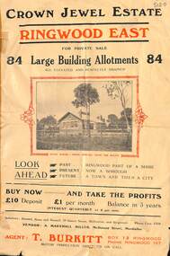
Flyer, Subdivisional Land Sale Brochure, Crown Jewel Estate, Ringwood East, Vic. - c.1925
In May 1884, George Smart of Bulleen Road Kew, brickmaker, bought the 23 acres one rood and twenty nine and three tenths perches, or 9.4834 hctares from Arthur Bailey Clements of Ringwood for the sum of 600 pound sterling. (Extract from The Story of the Crown Jewel Estate in Ringwood East pdf)Double sided folded page with black and red print on both sides advertising auction sale of residential and business sites and highlighting local facilities, services and layout of the estate.Subdivision includes Mount Dandenong Road, Valda Avenue, Evon Avenue, Mirabel Avenue, and Velma Grove. (Agent) T. Burkitt, Box 12 Ringwood, Phone Ringwood 157. Vendor: A. Marshall Miller, McDonald Street, Mordialloc. Solicitors: Russell, Bona and Russell, 19 Queen Street Melbourne, and Ringwood - Phone Cent. 4308. -
 Whitehorse Historical Society Inc.
Pamphlet - Advertising brochure, Arlington Estate
Estate Agent's advertising brochure for Arlington Estate,Estate Agent's advertising brochure for Arlington Estate, Blackburn including Molleton Street. Baldwin Street and Canterbury Road.Estate Agent's advertising brochure for Arlington Estate,arlington estate, blackburn, molleton street, canterbury road, baldwin street, land subdivision -
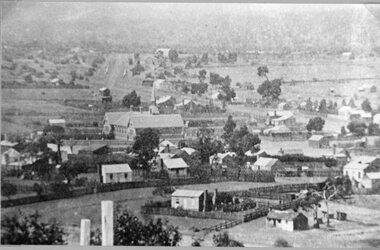
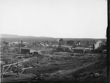 Stawell Historical Society Inc
Photograph, Panorama of Stawell Township taken from Big Hill c1905 -- 4 Photos
Panorama of Stawell Township c1910 Taken from Big Hill. Three original images in Photo Cabinet 3.stawell mining -
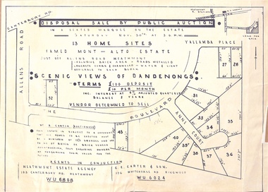 Ringwood and District Historical Society
Flyer - Auction, Mont-Alto Estate, Heathmont, Victoria - circa 1960
Single page advertisement for auction of 13 home sites on Saturday 30th November (1957?) with map of subdivsion, terms of sale, and reference to brick covenant. Subdivision includes Yallamba Place, The Boulevard, and Anne Court, Heathmont. Agents - Heathmont Estate Agency, 103 Canterbury Road, Heathmont (Telephone) WU6808, and C.E. Carter & Son, 126 Whitehorse Road, Ringwood, WU6024. Auctioneer - Mr. A. Carter."This Estate is subject to a covenant that all homes to be erected must be a minimum of 12-1/2 squares and are to be of brick or brick veneer construction, thus ensuring owners of preserving their value for the future." -
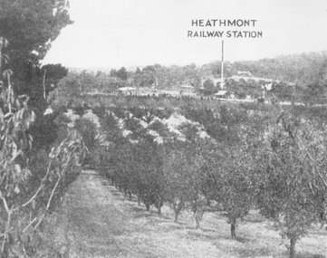 Ringwood and District Historical Society
Photograph, View of what was Heathmont township taken from about Royal Avenue looking at Mr. Herman Pump's orchard. Old bridge over Canterbury Road can be seen on left
Typed below photograph, "View of what was Heathmont township taken from about Royal Avenue looking at Mr. Herman Pump's orchard. Old bridge over Canterbury Road can be seen on left." -
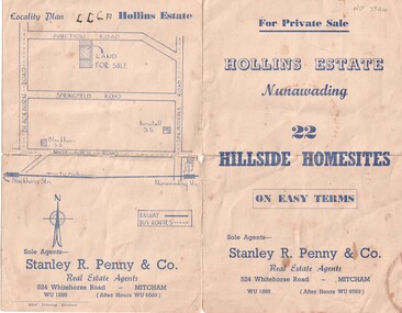 Whitehorse Historical Society Inc.
Document, Hollins Estate, 1955
Private sale of 22 hillside home-sites on Junction Road, Blackburn, called Hollins Estate by Stanley R. Penny & Co., 524 Whitehorse Road, Mitcham.hollins estate, stanley r. penny & co., real estate agents, blackburn, junction road, suto, joyce -
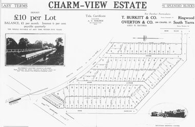 Ringwood and District Historical Society
Photograph, Land sale advertisement for Charm View Estate, Heathmont - 1927
Map - Charm-View EstateTyped below photograph, "From 1927 land subdivision brochure". -
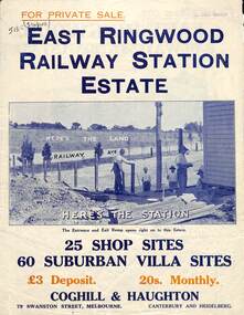 Ringwood and District Historical Society
Flyer, Land Sale Brochure, East Ringwood Station Estate - c.1925
Multi-fold double sided sheet with yellow and blue print and blue monotone photographs advertising private sale of retail and residential sites. Brochure includes price list, and details of subdivision features and local facilities, with photographs. Additional clipped map of Estate on cardboard backing with handwritten sales notations and title ref LP11245.Subdivision includes Railway Avenue, Dublin Road, Lawrence Grove, Stanley Avenue. Agents - Coghill & Haughton, 79 Swanston Street, Melbourne, Phone Central 2793. Photographs include construction of East Ringwood Railway Station, "The Dive" where aquatic sports are held, Old East Ringwood Township, Davey's Hill. -
 Clunes Museum
Photograph, 1865
VIEW IN TOWNSHIP CLUNES, SOUTH EAST. PERIOD 1865. TAKEN FROM HILLSIDE BELOW CAMP PARADE, VICINITY MR. SWANTON'S HOUSE PHOTOGRAPH OF TOWNSHIP OF CLUNES, SOUTH EAST .1 SEPIA PHOTOGRAPH MOUNTED ON CARDBOARD. .2 BLACK AND WHITE PRINT .3 SEPIA PHOTO PRINT .4 BLACK AND WHITE PHOTO PRINT .5 BLACK AND WHITE PHOTO PRINT HOUSES SURROUNDED BY PICKET FENCES, POPPET LEGS AND CHIMNEY STACK.VIEW IN TOWNSHIP CLUNES. SOUTH EAST.local history, photography, photographs, clunes township -
 Stawell Historical Society Inc
Photograph, Stawell Township looking towards Sister Rocks which includes Stawell East School 1880 -- later becoming Stawell High School
Stawell Township - includes Stawell East School 1880. Later Stawell High School. Looking towards Sister Rocks.stawell -
 Stawell Historical Society Inc
Photograph, Great Western Township looking North from Paxton Street c1890's
Great Western Township c1890's looking North from Paxton Street. Original Hotel. Store. Salinger's and Cottages.stawell -
 Kew Historical Society Inc
Plan - Subdivision Plan, Thornton Estate, 1918
The ‘Thornton Estate’ was the final subdivision of ‘Thornton’ in Studley Park Road. Thomas Cubitt Balmain originally owned Thornton, next to John Carson’s ‘Clutha’. Before its final subdivision, the Thomson family owned it. The Estate was a subdivision of 15 residential allotments running between Studley Park Road and Stevenson Street. The allotments faced these streets as well as Thornton Street, which the vendor undertook to make. Contemporary newspaper advertisements advised that ‘The estate possesses many advantages, notably its private and secluded, though convenient, position, splendid frontages and depths, and being close to the electric tram and Kew train, also within easy walking distance of the Victoria-street cable tram’. The terms offered purchasers were ten per cent deposit, with the balance to be paid in ten equal half-yearly payments at a rate of 5 per cent.The ‘Thornton Estate’ was the final subdivision of ‘Thornton’ in Studley Park Road. Thomas Cubitt Balmain originally owned Thornton, next to John Carson’s ‘Clutha’. Before its final subdivision, the Thomson family owned it. The Estate was a subdivision of 15 residential allotments running between Studley Park Road and Stevenson Street. The allotments faced these streets as well as Thornton Street, which the vendor undertook to make. Contemporary newspaper advertisements advised that ‘The estate possesses many advantages, notably its private and secluded, though convenient, position, splendid frontages and depths, and being close to the electric tram and Kew train, also within easy walking distance of the Victoria-street cable tram’. The terms offered purchasers were ten per cent deposit, with the balance to be paid in ten equal half-yearly payments at a rate of 5 per cent.subdivision plans - kew, thornton estate, studley park road -- kew (vic.), thornton avenue -- kew (vic.), stevenson street -- kew (vic.) -
 Ringwood and District Historical Society
Document - Folder, Byways Estate Residential Subdivision, Ringwood East, Victoria 1965-1970
Collection of Subdivision brochures, plans, maps and sales information for sectional releases of Byways Estate.Subdivision plans include: First and second release (1965-66) - Alexandra Road, Isabel Avenue, Byways Drive and Buronga Avenue. Third release (1967) - Byways Drive, Buronga Avenue, Hender Street, Lester Avenue and Jess Court. Fourth and final release (1970) - Hume Street, Walhalla Drive and Hender Street. (Agent) C.E. Carter & Son R.E.S.I. 126 Whitehorse Road, Ringwood, 3134 (Telephone) 870 2519, 870 6830, 870 6024, A.H. 723 3298, 870 4604, 870 6454. Accompanying handwritten sales notes researched in 2024 by Richard Carter - Carter Real Estate - "Vendors - Jessie May Cleland & Alan Cleland of (what became) 4 Bywats Drive. Vendors retired to Buronga near Mildura. Rex was (I think) their son. Jess Court reflects vendor's name. See also History of Byways & Coolooli by Richard Carter in RDHS archives." (Vic Collections RDHS 18023 refers.) -
 Kew Historical Society Inc
Plan - Subdivision Plan, Pointed Firs Estate, 1936
The Kew Historical Society collection includes almost 100 subdivision plans pertaining to suburbs of the City of Melbourne. Most of these are of Kew, Kew East or Studley Park, although a smaller number are plans of Camberwell, Deepdene, Balwyn and Hawthorn. It is believed that the majority of the plans were gifted to the Society by persons connected with the real estate firm - J. R. Mathers and McMillan, 136 Cotham Road, Kew. The Plans in the collection are rarely in pristine form, being working plans on which the agent would write notes and record lots sold and the prices of these. The subdivision plans are historically significant examples of the growth of urban Melbourne from the beginning of the 20th Century up until the 1980s. A number of the plans are double-sided and often include a photograph on the reverse. A number of the latter are by noted photographers such as J.E. Barnes.An almost identical plan of the ‘Pointed Firs Estate’ is in the State Library of Victoria. The plan unusually uses a photograph to show the panoramic views from the Estate. A prospective purchaser could expect to look across the Yarra Valley to Eaglemont and Heidelberg. The 36 lots advertised for sale faced Doncaster Road, Houghton Street, Maud Street and Thackray Street in Balwyn North.subdivision plans - balwyn, pointed firs estate -
 Clunes Museum
Map
MAP DATED JULY 21ST,1873MAP OF CLUNES WATER SUPPLY, TOWNSHIP OF CLUNES, SHOWING SYSTEM OF DISTRIBUTION.TOWNSHIP OF CLUNESlocal history, document, maps, clunes water -
 Eltham District Historical Society Inc
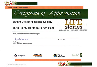
Certificate, Certificate of Appreciation, Yarra Plenty Regional Library to Eltham District Historical Society for hosting the Yarra Plenty Heritage Forum, 26 June 2012, 26/06/2012
EDHS hosted a quarterly meeting of the Yarra Plenty Heritage Group network of local history groups.A4 colour print certificate of appreciation, eltham district historical society, yarra plenty heritage forum, yarra plenty regional library -
 Eltham District Historical Society Inc
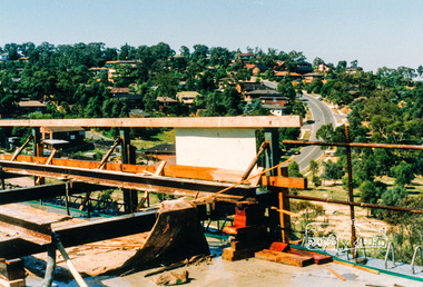
Photograph, Southeast view from new bridge over Plenty River looking along Plenty River Drive, Greensborough Bypass construction, c.1986, 1986c
Mura Close and Tangari Court visible on left, Warriparri Crescent on right of Plenty River Drive.Colour photograph originally located in a magnetic style album titled 'Greensborough Bypass 1990s 5' suffering significant degradation. No information contained in album or on reverse of photos except where noted. Relocated to archival photosafe storage.greensborough bypass, road construction, greensborough, mura close, tangari crescent, plenty river drive, warriparri crescent -
 Eltham District Historical Society Inc
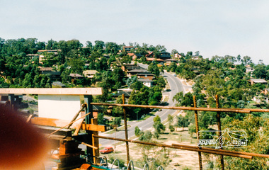
Photograph, Southeast view from new bridge over Plenty River looking along Plenty River Drive, Greensborough Bypass construction, c.1986, 1986c
Mura Close and Tangari Court visible on left, Warriparri Crescent on right of Plenty River Drive.Colour photograph originally located in a magnetic style album titled 'Greensborough Bypass 1990s 5' suffering significant degradation. No information contained in album or on reverse of photos except where noted. Relocated to archival photosafe storage.greensborough bypass, road construction, greensborough, mura close, tangari crescent, plenty river drive, warriparri crescent -
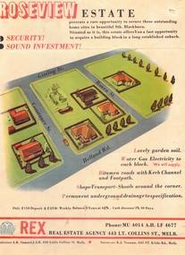 Whitehorse Historical Society Inc.
Document, Roseview Estate, 1959
Brochure for auction of 59 lots in 'Roseview Estate'Brochure for auction of 59 lots in 'Roseview Estate', Blackburn South, 14 March 1959. Agent : Rex Real Estate Agency.Brochure for auction of 59 lots in 'Roseview Estate'auctions, roseview estate, blackburn south, holland road, gissing street, rosen street, constance street, rex real estate agency -
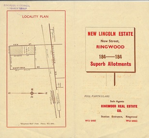 Ringwood and District Historical Society
Document - Folder, Land Sale Brochure, New Lincoln Estate, Ringwood, Vic. - circa 1960. Also 1951 newspaper advertisement
Bi-fold advertisement for sale of residential allotments - New Lincoln Estate, New Street, Ringwood, with summary of local facilities and services, locality plan, layout of sub-division, and price list. Also an advertisement from Ringwood Mail dated 12 July 1951. Subdivision includes New Street, Heywood Street, Barkly Street, Keith Grove, Maurice Avenue, Inez Avenue, Catherine Street, Neville Street, Neale Grove (later Heather Grove), and Sylvia Grove. Agent - Ringwood Real Estate Co., Station Entrance, Ringwood. (Phone) WU 6661, WU 6662.Accompanying handwritten sales notes researched in 2024 by Richard Carter - Carter Real Estate ... "Maurice Ashkanasy KC CMG owned the rectangular estate located between New, Barkly, Heywood Streets and Sylvia Grove in South-West Ringwood. It was given the name "The New Lincoln Estate". It was first advertised around July 1951 as "48 superb allotments", through Ringwood Real Estate (Station Entrance). A sub-divisional plan from CE Carter showed 152 blocks with 60-foot frontages and varying between 110 and 150 feet in length. Later, in 1954 house and land packages were offered through William White in Elsternwick - "Three modern bedrooms, large lounge-dining-room, kitchen with dinette, nicely equipped bathroom - £2,685 to £2,762, deposit £300". The roads were created and named after family members - Neale (later Heather) Grove - after Maurice's son Neal Mark Ashkanasy. The street was later re-named Heather Grove after Maurice's wife, Heather Helen Ashkanasy (Epstein), who passed away in 1999, aged 95. Neville Street - after Marice's other son, Aaron Solomon Neville Ashkanasy known as Neville. Catherine Street and Inez Street - after Heather's mother Catherine Inez Epstein. Maurice Avenue - after Maurice Ashkanasy, vendor. Keith Grove - after Keith Epstein. ..." -
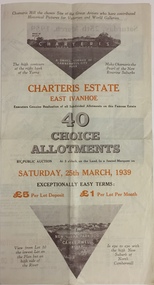 Kew Historical Society Inc
Plan - Subdivision Plan, Charteris Estate, East Ivanhoe, 1939
The Charteris Estate in Ivanhoe was sold in a number of sections. Copies of a subdivision plan of the first section is in the State Library of Victoria collection. This later section of the Charteris Estate includes lots in the Government Boulevard, Castella Street, McArthur Road, Burke Road North, Charteris Drive and Warncliff Road.Subdivision plans like that for the Charteris Estate are invaluable records for local historians identifying when lots in streets were promoted for sale.Four-fold brochure advertising the Charteris Estate in East Ivanhoe in 1939. Streets named on the plan include: the Government Boulevard, Castella Street, McArthur Road, Burke Road North, Charteris Drive and Warncliff Road. The brochure contains photos of Charterisville, the home of F De Castella Esq and also of attractive rolling hills. Annotations in pencilcharteris estate - east ivanhoe (vic), subdivision plans - east ivanhoe (vic) -
 Greensborough Historical Society
Newspaper Clipping, Domain Review et al, 10 Ellen Court Greensborough, 21/11/2018
11 Ellen Court Greensborough, 3 bedroom home, sold 21/11/2018 for $890,000; previous sales: September 2003 $325,000, May 1984 $73,500, December 1983 $21,000, and March 1980 $13,500.Real estate advertising in newspaper, colour imageellen court greensborough -
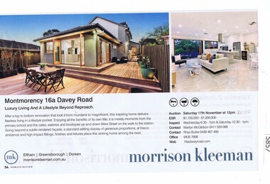 Greensborough Historical Society
Newspaper Clipping, Domain Review et al, 16a Davey Road Montmorency, 17/11/2018
16a Davey Road Montmorency, 4 bedroom home, sold 17/11/2018 for $1,050,000; previous sales: October 2012 $585,000. Real estate advertising in newspaper, colour imagedavey road montmorency -
 Greensborough Historical Society
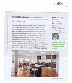
Newspaper Clipping, Domain Review et al, 51 Killarney Ridge Greensborough, 16/11/2018
51 Killarney Ridge Greensborough, 4 bedroom home, sold 16/11/2018 for $951,000; previous sales: December 2002 $178,000. Real estate advertising in newspaper, colour imagekillarney ridge greensborough -
 Greensborough Historical Society
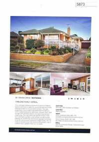
Advertising Leaflet, Buckingham and Company Estate Agents, 36 Orana Drive Watsonia, 2018_08
Advertising for 36 Orana Drive Watsonia, 3 bedroom house, sold December 2018 for $715,000. Colour page from real estate magazine.orana drive watsonia -
 Greensborough Historical Society
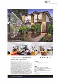
Advertising Leaflet, Buckingham and Company Estate Agents, 8 Glengala Court Greensborough, 2018_08
Advertising for 8 Glengala Court Greensborough, 3 bedroom house, sold October 2018 for $790,000; previous sales: February 2014 $552,500, April 1982 $68,000 and September 1977 $14,500. Colour page from real estate magazine.glengala court greensborough