Showing 972 items matching "tree planting"
-
 Federation University Historical Collection
Book, Victoria Education Gazette and Teachers' Aid, 1911-1919, 1910-1919
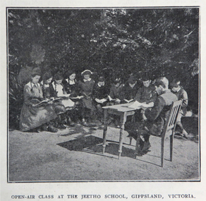
... , Arbour Day, Henry Harding of Yinnar, Planting Trees and Shrubs..., Arbour Day, Henry Harding of Yinnar, Planting Trees and Shrubs ...Black hard covered book with red spine, holding Victorian Education Gazettes for one calendar year. .1) 1910 .2) 1912 .3) 1911 .4) 1914 .5) 1918 Images: Open Air Classroom Black Rock; Open Air Classroom, Jeetho, Gippsland; Open Air Nurses bedroom, Mildura; Gym at Canterbury School ; Babies and Nurses at Melbourne Foundling Hospital; Camp at Portland; Alexander Peacock Opens a Melbourne School; Unveiling Major Mitchell Memorial at Mt Arapiles; Agricultural Plot; School Interior; Swimming Drill; Graham Dux Prize Board; Bathing Place; Classroom with blackboard and pictures; Major Mitchell's Map; Melbourne, Derbyshire; Market Place Melbourne; The Blackwood; World War One Send-off at The Athenaeum; Scarsdale Old Boy's logo; Sloyd articles for the Field Hospital; World War One; Gifts for Transport to the Wharf; soldiers; ANZAC Day; ANZAC Day Medalion .5) 1915: Education Department's War Relief Fund, William Park obituary, Closer Settlement Act 1912, Agriculture, needlework, Swimming and Life Saving, explorers, Gregory Blaxland, Matthew Flinders, Composition, Geography, potatoes, onions, gardens, Needlework for Infants, Iona and Staffa, Trained Primary Teacher's Course, Electricity, Electrical Technology, hygiene, Arbour Day, Horticulture, Wattle Day, Bird Day, Technical Schools, Landing at Gaba Tepe, Evils of Alcohol, Old Boys of Scarsdale, Belgium, Teachers' College Images: The British at War, The Sonnet, History and Patriotism, Male Swimming Teachers Summer School at Geelong, Women Swimming Teachers at Port Fairy, Buln Buln State School, Burwood East State School, needlework plans, methods of Rescue and Resucitation. plan of the journey of Gregory Blaxland, Macquarie House, teachers killed (William Ross Hoggart, Stanley Robert Close, William Roy Hodgson, Campbell McDiarmid Peter, William Henry Dawkins, William Hugh Hamilton, Frederick McRae Neal, Vernon Brookes, Frank J. Olle, Alfred J. Collins, Ernest R. Fairlie, William J. McLaren, A.E. Smith, Thomas Patton, Francis W. Kemp, Frederick G. Hall, Rupert O. Hepburn, Woolston J. Govan), Frederick Harold Tubb VC, Botanic Gardens Red Gum, Shelter Pavillions, Head of Wheat, Australian Commonwealth Flag, Iona Cathedral, Drawing exercises, ANZAC Madallion, School Rolls of Honor .6) 1916 - Nature Study, war relief, school gardening, horticulture, singing class, geography of the war, School Rolls of Honour, Ponsonby Carew-Smyth, Astronomy, ANZAC Day, Empire Day, Arbor Day, "Some Suul of Goodness in Things Evil" by Frank Tate, War Relief Gardeners' League, ANZAC Day medallion, Solar System, Abolition of German Schools in Victoria, ANZAC Avenues, avenues of honour, Geography of the War: The West, War relief and handwork, Victorian State Schools Horticultural Society, Patrick Maloney obituary, formalin lamps, Victoria League of Victoria, Wonwondah East Roll of Honor Images - Teachers killed (John Clarke, A.C.H. Jackson, Alexander Robertson, Noel Gambetta, Ralp E. Leyland, Laurance J. Woodruff, Walter E. Cass, Percy D. Moncur, Thomas M. Carmichael, Edward G. Brain, Reginald N.F. Woods, George E. James, William Colvin, David Dobson, Stanley L. Robinson, Charles Allen, G.E. James, H.F. Curnow, Franl L. Cousins, James R. Thompson, Henry H. Campbell, George E. Read, Ernest D. Morshead, Wilfred S. Merlin, Henry R. Wright, George B. Webb, Noel Nicholas, David H. Thomas, Charles A. Levens, Thomas R. Fenner, John M. Daniell, P.J. Larkin, Ralph Smith, Philip Ormsby), school rolls of honour, Swimming Instructors at Queenscliff, The Southern Sky, Map of the North Sea and its Littorals, Easter School of Horticulture at Oakleigh, Map of the Eastern Front, Map of Mesopotamia, Map of the War Area in the Egyptian Campaign, leeches for the Melbourne Hospital .7) 1917 - Swimming and Life-Saving, Childre's FLower Day, Education Department's War Relief Fund, State War Council, Horticulture, Bird Day, Swimming, Growing Chicory at Cowes Images - Teachers killed during World War One (G.M. Nicholas, William C.W. Spencer, J.W.C. Profitt, Ivon C. Bromilow, John Colwell, Robert W. Campbell, Arthur P. Bourchier, Francid G. Houston, Claude N. Harrison, Edgar Williams, Leslie A. Stevens, Charles E. W. Chester, Stanley R. Green, Walter Baker, Arthur G. Scott, Harry L. Swinburne, Horace W. Brown, Arnold Bretherton, Edward W. Jenkins Aubrey Liddelow, Ewen A. Cameron, Edmund R. Lyall, John H. Martin, Harry Bell, Frank L. Nicholls, Melville R. Hughes, Edwin W. Hauser, Walter S. Filmer, Walter G. Barlow, Henry A. Donaldson, Edward H. Jones, Walter W. Raw, Alfred W. Dean, Wiliam Lea, Frederick G. Drury, J.T. Richards, Norman G. Pelton, Lance-Corporal Doran, Kenneth F. McKenzie, William F. Robertson, Wiliam Jarrott, Norman Graham, George G. Paul, Victor Green, Arthur William Rennie, Alfred J. Glendinning, Robert B. Liston, Eward P. Toll, George Jones, Errol E. Rodda, Christian P. Christensen, Charles F. Sydes, H.G. Clements, Norman C. Fricker, J.M. Romeo. Eric N. Lear, Thomas J. Bartley, Norval Birrell, Frederick H. Tubb. J.T. Hamilton Aram, Arthur Wilcock, William M. Conroy, Alex. H. Miller, Patrick J. Cunningham, Charles S. Mitchell, John R. Maddern, James Roadknight, Harry Arundel, Jack C. McKellar, duncan M. McKellar, George S. Manfield, Edgar C. Holmes, George A. Young, Raymond A. Gardiner, William B. Bell, William Opie, George R. Scott, Richard V.B. Vine, Herbery S. Marshall, Hugh St Omer Dentry, George B. Fullerton, Harry Oulton, Iva F. Morieson), School Honor Books, Drawing, Presentation of 30,000 pounds to the British Red Cross at Melbourne Town Hall .8) 1918 .9) 1919 - Photographs of World War One soldiers from the Education Department, Margaret Montgomery Memorial, 1918 Act relating to State School Teachers, State Scolarships, Victorian State Schools' Horticultural Society, Pneumonic Influenza, Spanish Flu, epedemic, swimming and life savinfJunior cadet training, vacancies in Fiji, School Committees, Arbor Day, Arbour Day, Henry Harding of Yinnar, Planting Trees and Shrubs, Juvenile Crime, The use of 'Get', Soldier-Teachers from Overseas in Congress London, Australia's Effort in the War, Military, Working Bees, Tree Planting, fence building, Welcoming Home a Returned Soldier, Avenue of Honour planting, Discipline, Unveiling an Honor Board, School gymnasium, school tennis court, E. E. Crogger grave at Aldershot, The School Honor Book. War Relief Fund, Commonwealth War Record, Caulfield Military Hosptial, ANZAC Day Pilgrimage, Jimmie Panikin, Donald Fraser, Arthur Mee, Card Sun Dial, Balboa Day in Honolulu, William Hamilton, Alfred Jackson, The Backward Child, Flies, Language Teaching and Learning, Spelling, The Education of the Adolescent, victorian education gazette, education gazette and teachers' aid, sloyd, william a. cavanagh, james i froebel, school, education, world war one, memorials, alfred williams, exploration and settlement, cadets, australian naval college, bernard o;dowd, birds, swimming, drawingempire league, eucalypts, paper in history, forestry, arbor day, identification of trees, forestrey museums, fiji, gravel hill school band, horticulture, hygiene, gould league of bird lovers, life saving, la perouse, bandin, j. holland, w. hamilton, charles sturt, principles of archimedes, james holland, william hamilton, scarsdale old boys' reunion, foundling home melbourne, montessori education, open air schools, james hughes, marie corelli, flinders sydney harbour, major mitchell's map, tooth brushing, r.h.s. bailey -
 Melton City Libraries
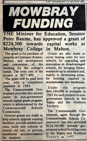
Newspaper, Mowbray Funding, Unknown
... ... During some classes we used to do horticultural work and planted... ... During some classes we used to do horticultural work and planted ..." Designed by architect Norman Day, the school was built in an innovative postmodern style. Day’s vision was for the school’s students to feel as comfortable and familiar at school as in their own homes. He based the design on the local suburban typology. The buildings consisted of individual self-contained classrooms, each with a front door, back door and garden. Each class retained the same homeroom for the duration of their schooling. Norman Day won the inaugural Lustig & Moar Architectural Prize in 1988 for his Mowbray College design, and the Australian Library Promotion Council/RAIA Library Design Award for the school’s library building. The school officially opened on 7 February 1983 with an enrolment of 93 students from Prep to Year 7. Mark Fergus was a Prep student in the school’s inaugural year. He later remembered: It was good then because everyone knew each other. Our first few weeks at school we had classes in the Guide Hall because the Mill wasn’t finished. The rest of the school where the Labs and Coppin Court are now was only a big paddock. Another Prep student, Brooke Harrison, recalled: The only recreation we had was the rough playground which consisted of monkey bars, old tractor tyres and a sandpit and high bars. Accidents were a frequent occurrence in those days! It was a friendly atmosphere, you know everyone and their business ... During some classes we used to do horticultural work and planted trees out the front of the school. In 2003, Mowbray College celebrated two decades of educating students in Melton. By that stage, the school had expanded to two campuses with over 1,450 students and 120 staff. It was estimated that over the twenty years since its establishment, 13,000 students passed through the gates. By the mid-2000s, the school offered an International Baccalaureate program and operated across three campuses: the original campus, named Patterson after the first principal, and the Brookside and Town Centre campuses, both located in Caroline Springs. Unfortunately, in 2012 Mowbray College found itself in an unmanageable situation. The community had lost faith in the school’s financial security and as a result some parents withheld their school fees, fearing the school would collapse. It had been in financial difficulty since the mid-2000s and by 2012 was $28 million in debt. 84 In June 2012, all three campuses closed and within four months, each of the campuses of the former Mowbray College had been purchased by other education institutes. Heathdale Christian College bought the original Mowbray campus and established its own campus there and Grace Children’s Services bought the Brookside campus. The Town Centre campus was purchased by Intaj Khan from the Western Institute of Technology but remained vacant after some failed attempts at re-establishing a school. In 2017 the Australian International Academy established an Islamic school on the site".The Express article about a grant for Mowbray Collegeeducation -
 Glen Eira Historical Society
Article - Outer Circle Linear Park
... Line, and a description of notable plants and trees. A double... Circle Railway Line, and a description of notable plants ...OUTER CIRCLE LINEAR PARK, joint submission by cities of Kew, Camberwell, Malvern and Caulfield. A bound fifteen page submission, dated 08/07/1985, by four councils urging the creation of the Outer Circle Linear Park. Includes map and photographs. OUTER CIRCLE RAILWAY: A PLAN FOR A LINEAR PARK, report of the Outer Circle Study Group. Bound booklet of one hundred and thirty five typewritten and photocopied pages about the creation of this park. The Introduction was signed by Tom Roper, Minister for Planning and Environment, and by Joan Kirner, Minister for Conservation, Forests and Lands. Undated but the Introduction states that public submissions must be received by 31/05/1988. Includes maps, sketches of proposed facilities, a history of the former Outer Circle Railway Line, and a description of notable plants and trees. A double sided, one page leaflet, published by the Murrumbeena Outer Circle Parkland Retention Group, MOCPRG, with timeline of the park and map. Undated but the last date on the timeline is 1985. Includes small sheet headed WHAT CAN YOU DO? Cutting from the CAULFIELD CONTACT titled A NEW PARK IT’S OFFICIAL, dated 26/02/1988, on official announcement of the new park. Two copies of OUTER CIRCLE LINEAR PARK, a four paged pamphlet published by Outer Circle Linear Park Implementation Committee on the new park. Includes detailed map. Letter between Felicitie E. Campbell of the Caulfield Historical Society, dated 14/09/1988 supporting the naming of a section of the Linear Park as Boyd Park. Two pages typed and a hand written copy. Also a type written letter from Jim Badger, Manager, Cultural Services, City of Caulfield, supporting the naming as Boyd Park, dated 16/08/1988. An album of thirty five colour photographs by Peter Foeden and Associates, of the official opening of the Outer Circle Linear Park by Premier John Cain, 1988. Photographs are numbered and the album includes handwritten descriptions of each photograph. Two mounted photographs of the Caulfield section of Linear Park, undated. One black and white and one colour.outer circle linear park, outer circle railway, parks, saunders r. e., briggs a. g., quinn m., rudski b., outer circle study group, roper tom, kirner joan, dunstan david, railways, trees, murrumbeena, campbell felicitie e., badger jim, peter foeden and associates, campbell adack, lang robert, gallney cr., cain john, cain nancy, boyd john, boyd arthur, boyd merric, boyd penleigh, boyd robyn, boyd james, boyd guy, ballantyne mr. -
 Nillumbik Shire Council
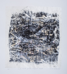
Print (woodcut and etching on chine-colle): John WOLSELEY (b.1938 Somerset, UK; arrived 1976 Melb., AUS), John Wolseley, 'Life world of the Longicorn beetle' from the 'Baldessin & Friends commemorative folio', 2016
... plants, birds, trees, rocks and earth of a particular place... of collaborating with the actual plants, birds, trees, rocks and earth ...Painter, printmaker and installation artist John Wolseley was born in Somerset, England. He lived and worked throughout Europe before relocating to Australia in 1976. His work explores how people dwell and move within landscape. Wolseley see's himself as a hybrid mix of artist and scientist; one who tries to relate the minutiae of the natural world - leaf, feather and beetle wing - to the abstract dimensions of the earth's dynamic systems. Using techniques of watercolour, collage, frottage, nature printing and other methods of direct physical or kinetic contact Wolseley finds ways of collaborating with the actual plants, birds, trees, rocks and earth of a particular place. George Baldessin was one of the first artists John Wolseley met when he arrived in Australia in 1976. Both immigrated to Australia and connected through this shared experience. They were both at 'Realities Gallery' with Marianne Baillieu in the 1970s and 80s. George Baldessin (1939-1978) was born in San Biagio di Callalta, in the Veneto in Northern Italy and arrived in Australia ten years later. A printmaker and sculptor he built his bluestone studio at St Andrews (Nillumbik) in 1971 with his partner Tess and the three Hails brothers, Rob, Doug and Don. Made of recycled materials the studio today contains all of George’s equipment including the large press, which he modelled himself with the help of Neil Jeffrey (Enjay Presses). George won many prizes throughout his career and is represented in many of Australia's public art collections including his famous 'Pears' sculpture in front of the National Gallery of Australia, Canberra. In 1975 he represented Australia in the Sao Paulo Biennale, before living and working in Paris until his return to St Andrews in 1977. In 1978 George was killed in a car accident aged 39 years. In 2001 Tess returned to St Andrews to reclaim the run-down studio and reconstitute it as The Baldessin Press & Studio - a printmaking retreat. It operates in George’s memory, so that artists may continue to create, perpetuating the generous spirit of George. 'Life world of the Longicorn beetle' is one of eight prints in the 'Baldessin & Friends commemorative folio. The folio was conceived by Tess Edwards as a fundraising initiative in celebration of the The Baldessin Press & Studio's fifteen year anniversary, and as a way to honour George Baldessin's memory. The Baldessin Press & Studio is a not-for-profit organisation created in memory of the late George Baldessin (1939-1978), whose original studio is now open to the public for creative use and as a practical legacy to living artists. The Studio is located in St Andrews, Nillumbik. The folio is a unique coming together of seven very different and acclaimed artists who are connected by their friendship to the missing eighth member, George Baldessin. Communion and collaboration with nature are central to Wolseley's practice. He assembles different drawing methods to represent a kind of inventory or document about the state of the earth. His interest is to paint the processes and energy field of the living systems of this land. 'Life world of the Longicorn beetle' is his continued exploration of Australia's natural eco-systems. The beetle attacks the eucalypt and in the process of tunnelling into the wood of the tree leaves scribbly patterns. The work celebrates the cycle of life, and the wisdom and delicacy of these creatures. This three dimensional work consisting of three layers of paper is a varied edition, offering just the slightest difference between each print, reflective of variation in nature. The found log used as a woodcut acknowledges the interconnectedness of nature and living beings; the log is not apart from the art and the beetle has become an active artistic collaborator. An intimate and layered print of a tree log with line trails from the Longicorn beetle. Patches of pink, yellow and orange watercolour placed randomly. Woodcut from found log and etching on chine-colle with water colour on Gampi (top layer), Mulberry (middle layer) and Arches (bottom layer) paper. In pencil (handwritten): low plate: left '14/25' (edition); centre 'Life world of the Longicorn beetle' (title); right 'John Wolseley' (signature); low paper: right emboss 'GB' (Baldessin Press & Studio monogram)woodcut, etching, chine-colle, landscape, environment, longicorn beetle, print, baldessin, ekphrasis2018, eco, mixed media -
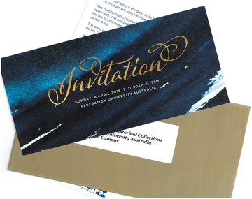 Federation University Historical Collection
Invitation, Invitation to Attend a Luncheon with HRH Prince Edward at Federation University Mt Helen Campus, 2018, 2018
... of the luncheon, HRH The Earl of Wessex planted a tree at the Student... planted a tree at the Student Commons Courtyard. The visit ...Federation University Australia showcased its students and research at a luncheon for His Royal Highness The Prince Edward, Earl of Wessex KG GCVO, at the Mt Helen Campus on Sunday, 8 April. The University’s student leaders and academics joined other dignitaries and business representatives for the special event. “The University is deeply honoured to host HRH The Earl of Wessex and share his passion for volunteerism and The Duke of Edinburgh’s International Award,” Professor Helen Bartlett, Vice-Chancellor, said. Prior to the luncheon HRH The Earl of Wessex experienced a Welcome to Country and Smoking Ceremony at the University. The program included showing HRH The Earl of Wessex concept plans for a refurbished Sports Science facility at the Mt Helen Campus. Guests were treated to a performance by the Arts Academy’s renowned vocal ensemble Word of Mouth. At the conclusion of the luncheon, HRH The Earl of Wessex planted a tree at the Student Commons Courtyard. The visit to the University by HRH The Earl of Wessex was the first by a member of the Royal Family since Prince Charles visited in 1974. HRH The Earl of Wessex was in Australia to attend the Commonwealth Games and undertake additional engagements to recognise and promote The Duke of Edinburgh’s International Award in Australia. HRH The Earl of Wessex, who is the Chair of The Board of Trustees of The Duke of Edinburgh’s International Award Foundation, attended 32 engagements across Melbourne, Ballarat, Hobart, Brisbane, and Adelaide, from formal receptions, Award presentations, meetings with government officials and the community sector, to meeting Award Participants and their families at community centres. The events enabled HRH The Earl of Wessex to engage with over 1,000 young people undertaking the Award, and over 3,400 Award volunteers and supporters who will have the opportunity to discuss their activities and showcase the work being done to help young Australians dream big, challenge themselves and find their purpose, passion and place in the world. HRH The Earl of Wessex’s visit celebrates significant milestones and growth in the diversity of The Duke of Edinburgh’s International Award program in Australia. “The Award’s relevance to all young Australians is as important today as it was when it started over 60 years ago,” Mr Peter Kaye AM, Chief Executive Officer of The Duke of Edinburgh’s International Award – Australia, said. “Employers in particular are recognising the ‘soft skills’ that are so necessary for a well prepared future employee.”Invitation and dress code in a gold envelope. Addressed "Ms Clare Gervasoni Curator, Art & Historical Colelctions Federation University Australia Mt Helen Campus"prince edward, earl of wessex, helen bartlett, visitors, royal visit -
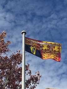 Federation University Historical Collection
Photograph - Photograph - Colour, Suzanne Godfrey, The Royal Standard Flying at Federation University Mt Helen Campus, 2018, 09/04/2018
... of the luncheon, HRH The Earl of Wessex planted a tree at the Student... planted a tree at the Student Commons Courtyard. The visit ...Federation University Australia showcased its students and research at a luncheon for His Royal Highness The Prince Edward, Earl of Wessex KG GCVO, at the Mt Helen Campus on Sunday, 8 April. The University’s student leaders and academics joined other dignitaries and business representatives for the special event. “The University is deeply honoured to host HRH The Earl of Wessex and share his passion for volunteerism and The Duke of Edinburgh’s International Award,” Professor Helen Bartlett, Vice-Chancellor, said. Prior to the luncheon HRH The Earl of Wessex experienced a Welcome to Country and Smoking Ceremony at the University. The program included showing HRH The Earl of Wessex concept plans for a refurbished Sports Science facility at the Mt Helen Campus. Guests were treated to a performance by the Arts Academy’s renowned vocal ensemble Word of Mouth. At the conclusion of the luncheon, HRH The Earl of Wessex planted a tree at the Student Commons Courtyard. The visit to the University by HRH The Earl of Wessex was the first by a member of the Royal Family since Prince Charles visited in 1974. HRH The Earl of Wessex was in Australia to attend the Commonwealth Games and undertake additional engagements to recognise and promote The Duke of Edinburgh’s International Award in Australia. HRH The Earl of Wessex, who is the Chair of The Board of Trustees of The Duke of Edinburgh’s International Award Foundation, attended 32 engagements across Melbourne, Ballarat, Hobart, Brisbane, and Adelaide, from formal receptions, Award presentations, meetings with government officials and the community sector, to meeting Award Participants and their families at community centres. The events enabled HRH The Earl of Wessex to engage with over 1,000 young people undertaking the Award, and over 3,400 Award volunteers and supporters who will have the opportunity to discuss their activities and showcase the work being done to help young Australians dream big, challenge themselves and find their purpose, passion and place in the world. HRH The Earl of Wessex’s visit celebrates significant milestones and growth in the diversity of The Duke of Edinburgh’s International Award program in Australia. “The Award’s relevance to all young Australians is as important today as it was when it started over 60 years ago,” Mr Peter Kaye AM, Chief Executive Officer of The Duke of Edinburgh’s International Award – Australia, said. “Employers in particular are recognising the ‘soft skills’ that are so necessary for a well prepared future employee.”Photograph of the Royal Standard Flying on the Federation University Mt Helen Campus flagpoles during the visit of HRH the Prince Edward, Earl of Wessex, KG GCVO. Prince Edward visited the Mount Helen campus as the Chair of the trustees of The Duke of Edinburgh's International Award Foundation. The award is the world's leading youth achievement award. It has helped inspired, empower, connect and recognise the achievements of more than 8 million young people in more than 140 countries. The Award presents a balanced, non-competititive program of voluntary activites that encourage personal discovery, growth, resilience, perseverance, responsibility and community service. It is about individual challenge and encouraging young people to become mature and active citizens who positively contribute to society, through activities that inspire them.prince edward, earl of wessex, royal visitor, duke of edinburgh's international award foundation, federation university, royalty -
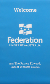 Federation University Historical Collection
Poster, Federation University Australia Welcome to HRH Prince Edward, 2018, 09/04/2018
... of the luncheon, HRH The Earl of Wessex planted a tree at the Student... planted a tree at the Student Commons Courtyard. The visit ...Federation University Australia showcased its students and research at a luncheon for His Royal Highness The Prince Edward, Earl of Wessex KG GCVO, at the Mt Helen Campus on Sunday, 8 April. The University’s student leaders and academics joined other dignitaries and business representatives for the special event. “The University is deeply honoured to host HRH The Earl of Wessex and share his passion for volunteerism and The Duke of Edinburgh’s International Award,” Professor Helen Bartlett, Vice-Chancellor, said. Prior to the luncheon HRH The Earl of Wessex experienced a Welcome to Country and Smoking Ceremony at the University. The program included showing HRH The Earl of Wessex concept plans for a refurbished Sports Science facility at the Mt Helen Campus. Guests were treated to a performance by the Arts Academy’s renowned vocal ensemble Word of Mouth. At the conclusion of the luncheon, HRH The Earl of Wessex planted a tree at the Student Commons Courtyard. The visit to the University by HRH The Earl of Wessex was the first by a member of the Royal Family since Prince Charles visited in 1974. HRH The Earl of Wessex was in Australia to attend the Commonwealth Games and undertake additional engagements to recognise and promote The Duke of Edinburgh’s International Award in Australia. HRH The Earl of Wessex, who is the Chair of The Board of Trustees of The Duke of Edinburgh’s International Award Foundation, attended 32 engagements across Melbourne, Ballarat, Hobart, Brisbane, and Adelaide, from formal receptions, Award presentations, meetings with government officials and the community sector, to meeting Award Participants and their families at community centres. The events enabled HRH The Earl of Wessex to engage with over 1,000 young people undertaking the Award, and over 3,400 Award volunteers and supporters who will have the opportunity to discuss their activities and showcase the work being done to help young Australians dream big, challenge themselves and find their purpose, passion and place in the world. HRH The Earl of Wessex’s visit celebrates significant milestones and growth in the diversity of The Duke of Edinburgh’s International Award program in Australia. “The Award’s relevance to all young Australians is as important today as it was when it started over 60 years ago,” Mr Peter Kaye AM, Chief Executive Officer of The Duke of Edinburgh’s International Award – Australia, said. “Employers in particular are recognising the ‘soft skills’ that are so necessary for a well prepared future employee.”Blue Federation University poster created to welcome HRH Prince Edward to the Mount Helen Campus poster, banner, prince edward, royal visitor -
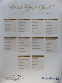 Federation University Historical Collection
Photograph - Colour, Clare Gervasoni, Federation University Seating Arrangement for lunch with HRH Prince Edward, 2018, 09/04/2018
... of the luncheon, HRH The Earl of Wessex planted a tree at the Student... planted a tree at the Student Commons Courtyard. The visit ...Federation University Australia showcased its students and research at a luncheon for His Royal Highness The Prince Edward, Earl of Wessex KG GCVO, at the Mt Helen Campus on Sunday, 8 April. The University’s student leaders and academics joined other dignitaries and business representatives for the special event. “The University is deeply honoured to host HRH The Earl of Wessex and share his passion for volunteerism and The Duke of Edinburgh’s International Award,” Professor Helen Bartlett, Vice-Chancellor, said. Prior to the luncheon HRH The Earl of Wessex experienced a Welcome to Country and Smoking Ceremony at the University. The program included showing HRH The Earl of Wessex concept plans for a refurbished Sports Science facility at the Mt Helen Campus. Guests were treated to a performance by the Arts Academy’s renowned vocal ensemble Word of Mouth. At the conclusion of the luncheon, HRH The Earl of Wessex planted a tree at the Student Commons Courtyard. The visit to the University by HRH The Earl of Wessex was the first by a member of the Royal Family since Prince Charles visited in 1974. HRH The Earl of Wessex was in Australia to attend the Commonwealth Games and undertake additional engagements to recognise and promote The Duke of Edinburgh’s International Award in Australia. HRH The Earl of Wessex, who is the Chair of The Board of Trustees of The Duke of Edinburgh’s International Award Foundation, attended 32 engagements across Melbourne, Ballarat, Hobart, Brisbane, and Adelaide, from formal receptions, Award presentations, meetings with government officials and the community sector, to meeting Award Participants and their families at community centres. The events enabled HRH The Earl of Wessex to engage with over 1,000 young people undertaking the Award, and over 3,400 Award volunteers and supporters who will have the opportunity to discuss their activities and showcase the work being done to help young Australians dream big, challenge themselves and find their purpose, passion and place in the world. HRH The Earl of Wessex’s visit celebrates significant milestones and growth in the diversity of The Duke of Edinburgh’s International Award program in Australia. “The Award’s relevance to all young Australians is as important today as it was when it started over 60 years ago,” Mr Peter Kaye AM, Chief Executive Officer of The Duke of Edinburgh’s International Award – Australia, said. “Employers in particular are recognising the ‘soft skills’ that are so necessary for a well prepared future employee.”Photograph of the seating arrangements for the dinner with HRH Prince Edward at Federation University Mount Helen Campus poster, prince edward, royal visitor, seating arrangement -
 City of Moorabbin Historical Society (Operating the Box Cottage Museum)
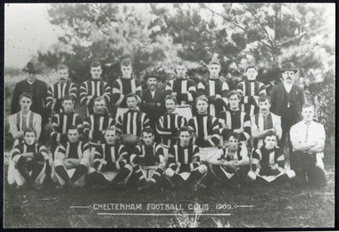
Photographs, x 3 Black & White Cheltenham Football Club 1909,1913, 1946, 20thC
... and erected a post and rail fence around the ground. Pine tree shrubs... and erected a post and rail fence around the ground. Pine tree shrubs ...Known as the Rosellas, the early Cheltenham Football Club sides began playing on a regular basis in 1890, and would travel long distances by steam train to play country teams, such as Ballarat where they would arrive at their destination, play the match, socialize then return to the station. Opposition players and supporters would give three hearty cheers on their departure. The Cheltenham home games were played on a paddock on the corner of Park and Charman roads in Cheltenham. In 1907 the Cheltenham progress committee made an application to the board of land works for land in Weatherall Road for recreational service to the public. That application was received and granted, then developed where Cheltenham Recreational Reserve now stands. The land in the early days was virgin bush and the response for voluntary help to clear the area was outstanding. Nearly all the market gardeners in the district along with horses, ploughs, axes, shovels completely cleared the area in three weeks. The Moorabbin council then leveled the playing area and erected a post and rail fence around the ground. Pine tree shrubs were then planted on the west side of the ground. The ground was opened in 1909 and the first Cheltenham side entered in the newly formed Federal Football Association along with seven other foundation members, Mordialloc, Mentone, Moorabbin, Frankston, Glenhuntly, Elsternwick, and Ellindale. The grand final for that year, 1909 was a hard encounter between Cheltenham and Ellindale with Cheltenham coming out victors, thus becoming the inaugural Federal Football Association premiers. Cheltenham went onto win five senior premierships in the Federal Football Association by the end of the 1920s, they won the flags in 1909, 1911, 1913, 1922 and 1925, with the late Percy Woff playing in all 5 premiership sides and was captain in 1922. 1928 saw the start of an outstanding career from our oldest living player Tom Connor. Cheltenham continued to win premierships in the 1920’s and 1930’s with juniors taking out the 1929 and 1933 flags, under the guidance of Woff, and that continued in 1934 when Cheltenham took out the 1st XVIII and 2nd XVIII premierships. Cheltenham produced its only Brownlow medallist in Peter Box who played in the late 1940s, before going to Footscray where he became a champion. The 3rd XVIII went through the season undefeated in 1974 winning the premiership, with Trevor Barker a key player before going to St Kilda the following year. The club won three senior premierships under coach Barry White in 1992, 1993 and 1995. ( from CFNC website 2019) Cheltenham Football Club was formed 1890 and succeeded in winning many Premierships as a member of the Federal Football Association, Outstanding players Peter Box Brownlow Medalist 1956 Footscay VFL, , Trevor Barker and Kevin Roberts St Kilda VFL.3x Black & White photographs of the players in the Australian Rules Cheltenham Football Club 1909, 1913 and 1946 extra photo of Peter Box Folio 10 MAV 01059a) CHELTENHAM FOOTBALL CLUB 1909 Cheltenham Football Club 1909. Back row: A Chandler, committee member; R. Robertson, back-pocket; J. Harris, half back flank; J Adams, ruck and forward-pocked; M. J. Monk, club president; L. Woff, back-pocket; W. Adams, ruck and back-pocket; P. Woff, rover and forward-pocket; A Monk, committee member. Middle row: W. Hore, back pocket and ruck; A. Towns, half-forward flank; W. Carson, full back; F. Andrews, captain-half forward flank; H. Butler, centre half back; J. Warburton, centre half-forward; A. Slater, half-back flank; F. Fisher, half-forward flank; C. Sherwood, trainer. Front Row: G Gouldthorpe, wing; H. King, full-forward; W. Johnston, ruck and forward-pocket; P Spears, rover and forward-pocket; F. Bichl, wing; A. Bichl. rover and forward-pocket; F. Butler, centre player. Courtesy, Lionel Seal. ( from CFC website 2019) b) CHELTENHAM 1913 PREMIERS c) CHELTENHAM -1946 / Back row - J. Fisher, G.Corrigan, N.Hocking, F.Virtue, R.Craven, L.Baker, M.Blundell / 2nd Row - J.Phillips, T.Connor, E.Hawkins, A.Blakely, G.Baker, A.Dark, J.Barker, D.Craven, J.Pickering, P.Cameron,/ W.Hicks, G.Hoskings, R.Beihl, A.Hubbard, R.Kier, C.Russell. / Front Row - Clark Taylor, J.Slade, N.Niel, J.Brooks, T,Butler, H.Hosking, C.Hacusler, E.Hornibrook, W.Briggs, B.Russell, L.Biehl, / W Ripponcheltenham football club, australian rules football, victorian football association, victorian football league, smith j l; smith mary ann, stanley helen, , chaff cutter, horse drawn carts, toll gates brighton, motor cars 1900, steam engines, early settlers, bentleigh, parish of moorabbin, city of moorabbin, county of bourke, moorabbin roads board, shire of moorabbin, henry dendy's special survey 1841, were j.b.; bent thomas, o'shannassy john, king richard, charman stephen, highett william, ormond francis, maynard dennis, market gardeners, vineyards, orchards, cheltenham, two acre village, holloway josiah,, woff percy, connor tom, box peter, barker trevor, white barry, browlow charles, -
 Eltham District Historical Society Inc
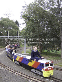
Photograph - Digital Photograph, Marguerite Marshall, Diamond Valley Railway, Eltham Lower Park, 7 September 2008
... trees and bushes planted by volunteers, stands on crown land... trees and bushes planted by volunteers, stands on crown land ...Kids of all ages enjoy the Miniature Railway. Published: Nillumbik Now and Then / Marguerite Marshall 2008; photographs Alan King with Marguerite Marshall.; p163 On Sundays in Eltham thousands of children, mums, dads and grandparents can be seen travelling around Lower Eltham Park in tiny trains. They are among the two and half million passengers who have travelled on the Diamond Valley Railway since it officially began in 1961. The miniature railway originally operated from the 1940s at Chelsworth Park, Ivanhoe, until flooding caused it to be moved to the Eltham Lower Park in 1959. The railway is modelled on the 1920s era – the heyday of passenger rail travel – and the trains are built on a scale of two inches to the foot (1/6). Although not exact replicas, trains include models of the Spirit of Progress, Puffing Billy, The Overland, Dog Boxes, Vic Rail S class, G class and a NSW 81 Class. The three and a half kilometres of track is set amongst native plants and picnic areas. A friendly hoot or the clang of a bell occasionally punctuates the tranquillity as a train emerges from a treed bend with passengers excitedly waving to onlookers. For $3 the train takes you on a 13-minute two-kilometre ride. Passengers sit in single file in the narrow train, which clatters along tracks built to the scale of the Australian narrow gauge of three feet six inches (1.1m). These are used in Queensland, South Australia, Tasmania and Western Australia. Safety standards are stringently kept. Even before you buy a ticket notices tell you that you must wear closed shoes. You can even borrow these, and you are given a pair of socks for the ride! Blue-overalled volunteers check tickets, see you aboard, and drive the train. They are mainly retired men who can at last devote their time to what little boys dream of – playing with trains. Passengers are instructed in safe behaviour, then the station master waves a white flag and off we go. The guard sits at the back with his whistle and green flag at the ready. The winding track, fringed by native trees and bushes planted by volunteers, stands on crown land managed by Nillumbik Council. The train clatters along the track and crosses a bridge over a drain elevated by name to The Blow Fly Creek. We pass by Meadmore Junction at a speed of three kilometres an hour. Then on through a tunnel, accompanied by squeals of delight, and after a few moments of blackness, light glimmers at the end. On we go, past the original platform, along another route past busy Main Road through Pine Creek Station, over a bridge and through another tunnel with more screams of delight.Then a signal stops us before the ‘all clear’ to return to our original point of departure. The railway services its passengers – the largest number of any miniature railway in Australia – with a fleet including: six diesel locomotives, three steam locomotives, eight sets of passenger cars and one battery electric Dog Box set. Members also privately own 20 locomotives and powered carriage sets as well as four carriage sets.1 All the trains are stored on-site in workshops, sheds and a tunnel. The railway is entirely run by volunteers, so that all ticket money is used for maintenance and extensions, and some goes to local charities. Since 1991, the entire railway has been rebuilt, including an upgraded signalling system. About half of the 120 volunteer members are active with about 35 working each Sunday, and a dozen or so working every Wednesday. Members are trained to positions of station assistant, booking officer, train guard, train driver or signalman. Members construct new carriages and locomotives as well as maintaining track, signalling and rolling stock.This collection of almost 130 photos about places and people within the Shire of Nillumbik, an urban and rural municipality in Melbourne's north, contributes to an understanding of the history of the Shire. Published in 2008 immediately prior to the Black Saturday bushfires of February 7, 2009, it documents sites that were impacted, and in some cases destroyed by the fires. It includes photographs taken especially for the publication, creating a unique time capsule representing the Shire in the early 21st century. It remains the most recent comprehenesive publication devoted to the Shire's history connecting local residents to the past. nillumbik now and then (marshall-king) collection, diamond valley railway, eltham lower park -
 Eltham District Historical Society Inc
Photograph - Digital Photograph, Alan King, Panton Hill Hotel, 27 March 2008
... at their orchard in Cherry Tree Road. Many settlers planted vineyards... at their orchard in Cherry Tree Road. Many settlers planted vineyards ...Today’s Panton Hill Hotel was built around 1920. Published: Nillumbik Now and Then / Marguerite Marshall 2008; photographs Alan King with Marguerite Marshall.; p61 Panton Hill was originally known as Kingstown, and consisted of only one hotel when the Orams Reef was discovered in 1859. Kingstown was a quartz mining centre and many old mine shafts remain in the area. Orams Reef was one of the first reefs with a rich find of gold in the area. The Hotel Francais, which had been operating in 1861, was well situated on the way to Queenstown (later St Andrews). So was Herr Hirt’s Hotel and store at Smiths Gully. The Kingstown hotel, known as the Frenchman’s and in 1864 as the Hotel de France, was run by a Monsieur Emile Hude and his wife Jeanne, and known for its good food. They hosted social events, business conventions and debates, attracting patrons from as far as Melbourne. The hotel’s name was changed to Panton Hill Hotel in 1905. In 1883 Charles Caudwell built another hotel nearby, possibly in Long Gully Road,3 which it is thought, was burnt down early last century. Today’s Panton Hill Hotel, built around 1920, is the only one of the cluster of buildings in the main road, not to date from around the turn of last century. It was severely damaged by fire in 2003, then underwent extensive alterations. It is the township’s only hotel and is an example of a modest hotel building exterior, constructed early last century. In its early days the hotel also housed the first post office, newsagency and store. Orams Reef yielded a total of £100,000, and fossikers also found alluvial gold in the creeks and gullies, but there is no record of the total value of their finds. Gold greatly increased the Panton Hill population, which peaked between 1865 and 1885. On holidays large sports meetings were held with wood chopping contests and foot races and the day would end with a ball. Miners came from various countries to seek their fortune, including many from China. The Chinese became unpopular however, and gradually left the district, although some stayed and grew and sold vegetables.5 Panton Hill was named after Joseph Panton, who in 1862 was appointed Police Magistrate for the Woods Point, Heidelberg and Yarra districts. Panton was an outstanding man, who in 1852, was Commissioner of Crown Lands and Assistant Commissioner of Goldfields at Bendigo. In 1874 he was promoted to Chief Magistrate for the Melbourne Police. Panton was also an artist, becoming president of the Victorian Arts Society in 1888, and in 1913, president of the Royal Geographical Society. Despite Panton Hill’s prosperity, it still lacked many services as poor roads made access to Melbourne difficult. A horse-drawn mail coach travelled to Melbourne until 1890, when the railway came to Heidelberg. The nearest doctor was at Yarra Glen or Heidelberg, and the Indian hawker Singh’s annual visit was very welcome. A miner’s shack opposite the school was used as a post office. Today’s general store and post office in the main road dates from early last century, and has changed considerably. While most people searched for gold, the more enterprising ones established farms to feed the diggers. Farmers grew wheat, barley and oats, and sent animal skins to the Eltham tannery, to make furs in Melbourne. As gold became scarce from around 1880, miners took up farming on 19 to 20 acre (8ha) allotments. The first settlers in Cherry Tree Road included Purcell, Smith, Owens, Hughes and Shillinglaw. By 1900 all the land had been taken up around Panton Hill and Hurstbridge. The orchards in Panton Hill and the wider district, particularly of apple and pear, were very successful, and made Panton Hill a cohesive and successful community. About 1914 the Moores built the first cool-store and refrigeration plant at their orchard in Cherry Tree Road. Many settlers planted vineyards and made high quality wine, but in 1922 the blight destroyed them.This collection of almost 130 photos about places and people within the Shire of Nillumbik, an urban and rural municipality in Melbourne's north, contributes to an understanding of the history of the Shire. Published in 2008 immediately prior to the Black Saturday bushfires of February 7, 2009, it documents sites that were impacted, and in some cases destroyed by the fires. It includes photographs taken especially for the publication, creating a unique time capsule representing the Shire in the early 21st century. It remains the most recent comprehenesive publication devoted to the Shire's history connecting local residents to the past. nillumbik now and then (marshall-king) collection, panton hill hotel -
 Eltham District Historical Society Inc
Photograph - Digital Photograph, Alan King, Heritage apple tree, 24 January 2008
... that Melbourne Founder John Batman may have planted the tree and later... that Melbourne Founder John Batman may have planted the tree and later ...This old apple tree situated beside the Plenty River Trail at Greensborough has been associated with Melbourne Founder John Batman. Known as Batman's Tree, this apple tree is on the bank of the Plenty River near Leischa Court, Greensborough. It is said that Melbourne Founder John Batman may have planted the tree and later signed his treaty here with the Aboriginal people. It still bears fruit and its recorded on the National Trust's Register of Significant Trees, as the oldest apple tree in Victoria. Published: Nillumbik Now and Then / Marguerite Marshall 2008; photographs Alan King with Marguerite Marshall.; p7 Was This John Batman's Tree? An apple tree on the bank of the Plenty River near Leischa Court, Greensborough, is believed to have belonged to Melbourne’s founder, John Batman. It could also stand where John Batman signed his famous treaty with the Aboriginal people.1 Known as Batman’s Tree, it still bears fruit and is recorded on the National Trust’s Register of Significant Trees, as the oldest apple tree in Victoria. It is ‘Believed to have been planted by either John Batman, (c1837) or Martin Batey (1841)’.2 In 1966 a Horticultural Adviser, Mr Rolfe, after extensive questioning of aged Greensborough residents, wrote: ‘it thus seems fairly certain that the old tree on the banks of the Plenty River is an original Batman apple tree’. Mr Rolfe said that the tree stood on a spot formerly called Wattle Bend: ‘one of the sites claimed to be where John Batman signed his famous treaty with the aboriginals. ‘My main source of information has been interviews with people who attended school in the Greensborough area from 70 to 80 years ago. Their parents were close to the days when Melbourne was founded so information passed on by word of mouth.’ Around 1920 the tree was struck by lightning and a concrete block was placed in the split. The concrete is inscribed with the date 1841 when the tree was thought to have been planted. Not everyone agrees with Mr Rolfe however. Former secretary of the Nillumbik Historical Society, Kevin Patterson, said there was no written evidence to support the claim. But he said the tree had been known to locals for decades as Batman’s Tree. In the 1920s a holiday resort in the area advertised: ‘Come to Greensborough and see John Batman’s tree’. Mr Patterson said it was thought that when Batman died in 1839 his land was sold and a Greensborough man Frederick Flintoff bought seedlings from his orchard for £1 each. This was the only one left.3 Mr Rolfe said: ‘If planted in 1837, or even a few years later, it undoubtedly is the oldest living apple tree in Victoria. Title records of the property on which the tree grows show that the land was a crown grant of F D Wickham in 1840. Mr Wickham was reputed to be a friend of John Batman. All the early settlers prior to the crown grants were squatters, by virtue of Batman’s treaty. This treaty was revoked by the then New South Wales Government, so it is likely that Wickham or an agent was in occupation before 1840. ‘According to Mrs Mavis Latham (John Batman – Great Australian Series, Oxford University Press) when Batman came to Port Phillip in 1835 he brought fruit trees with him. He failed to get a crown grant for his selection on Collins Street, which included 20 acres (eight ha) of orchard and cultivation. His residence became the Government Office and Melbourne grew from wild bushland in 1835 to a town of over 20,000 people by 1841. It is possible Batman visited Wickham and presented him with a tree.’ However a Flintoff descendant in 1933 said Frederick Flintoff ordered his bailiff Martin Batey to transplant the Batman Tree from the Spencer Street orchard to its present site as a memorial to his friend Batman.4 Mr Rolfe spoke to many people, including descendants of the Bateys and Flintoffs and pupils at the Greensborough Primary School. Many had gained their information from a ‘very highly respected’ head master Lewis Amiet at the Greensborough School from 1895 to 1917. He must have gained this information from residents in the district and had this information been incorrect, the parents of the children would have promptly corrected him.’ One woman who attended the school before Mr Amiet’s appointment, said the previous teacher also taught that the tree on the Plenty River was a Batman tree, Mr Rolfe said.This collection of almost 130 photos about places and people within the Shire of Nillumbik, an urban and rural municipality in Melbourne's north, contributes to an understanding of the history of the Shire. Published in 2008 immediately prior to the Black Saturday bushfires of February 7, 2009, it documents sites that were impacted, and in some cases destroyed by the fires. It includes photographs taken especially for the publication, creating a unique time capsule representing the Shire in the early 21st century. It remains the most recent comprehenesive publication devoted to the Shire's history connecting local residents to the past. nillumbik now and then (marshall-king) collection, greensborough, john batman tree, plenty river trail -
 Eltham District Historical Society Inc
Photograph - Digital Photograph, Alan King, Eltham Living and Learning Centre, 26 January 2008
... and planted fruit trees and a vegetable garden. In the early 1970s... and planted fruit trees and a vegetable garden. In the early 1970s ...In 1857, tanner John Pearson purchased three and a half acres of land in Little Eltham, at the western end of Pitt Street, with a 70-foot frontage to Maria Street (Main Road) and stretching down to the Diamond Creek for £100. He contracted Benjamin Oliver Wallis to build house for him. Wallis, a mason by trade who originated from the Cornish village of Newlyn, migrated to Melbourne in 1853 and was shortly engaged by Richard Warren to build the Eltham Hotel, which opened in 1854. When Warren fell into financial difficulty in 1858, Wallis purchased the hotel. That same year, Pearson constructed a tannery below the house with access to the water in the Diamond Creek. When Pearson became bankrupt in 1867, Wallis similarly acquired the house from Pearson’s creditors in 1868 and lived there until his death in 1896. For some of this time the house was in the name of Wallis’s son Richard but following his death in 1888, ownership reverted to his father. It was purchased by retired teacher Richard Gilsenen in 1899. Gilsenen was made acting head teacher at the Eltham State School in 1906 following the sudden death of head teacher John Brown. In the 1950s the house was bought by retired engineer Dr Alfred Fitzpatrick and his wife Claire who made various modifications to house goats and poultry as well as structural modifications to the house. In the early 1970s, Eltham Shire Councillors Frank Maas and Don Maling proposed an extended communities’ activities program be set up and the Commonwealth Grants Commission was approached for financial assistance. In 1974 a $50,000 Commonwealth Grant was received by the Shire Council to acquire the Fitzpatrick property as part of the planning to establish an extended communities’ activities program. The Fitzpatricks moved next door and Claire taught at the new Living and Learning Centre, which began in 1975, one of the first community education centres in Victoria. Covered under Heritage Overlay, Nillumbik Planning Scheme. Published: Nillumbik Now and Then / Marguerite Marshall 2008; photographs Alan King with Marguerite Marshall.; p59 It’s a centre for sharing knowledge and friendship and it stands on the former hub of Eltham’s original township near Pitt Street. The Eltham Living and Learning Centre, with around 2000 participants a year, began in 1975 as one of the first Community Education Centres in Victoria. Classes ranging from macramé to wine making to environmental living have enriched the lives of thousands of people through the generosity of tutors sharing their skills free of charge. The centre’s heart is the brick cottage, built in 1858 by tanner John Pearson. He bought the three and a half acre (1.4ha) allotment fronting Maria Street (now Main Road) and stretching down to the Diamond Creek. The allotment formed part of a 316 acre (127.8ha) subdivision, owned by Josiah Holloway, called Little Eltham, north of the original Eltham Reserve.1 The allotment then passed through the hands of several speculators before it was sold to Pearson for £100 in 1857. Mr Pearson’s children attended the Eltham Primary School from 1864 to 1867. But creditors took possession of the property when his tannery folded in 1867. It was then sold to publican Benjamin Wallis, who owned the Eltham Hotel at the corner of Pitt Street and Main Road. In 1899 the property was bought by Richard Gilsenan, who became acting head teacher of the Eltham Primary State School in 1906. In the 1950s, retired engineer Dr Alfred Fitzpatrick and his wife Claire bought the property, and made structural changes. Claire, a journalist and community campaigner, modified and built pens for goats and poultry, a stable, a garage and planted fruit trees and a vegetable garden. In the early 1970s a young woman called Carina Hack approached Gwen Wesson at the Diamond Valley Learning Centre (Victoria’s first Community Education Centre) about starting a community centre. Following Wesson’s suggestion, Hack spoke to Shire President Alistair Knox ‘one bleak rainy afternoon, sipping hot drinks and discussing life’.2 Eltham Shire Councillors Frank Maas and Don Maling proposed a community activities program and the council received a $50,000 Commonwealth Government Grant for this venture.3 The Fitzpatricks sold their property to the council and moved next door and Claire taught at the new centre, which Hack named. Eltham obviously wanted such a centre as Hack recalls. ‘During the next two months we had about 50 volunteers working day, night and weekends, scrubbing down, plastering and painting walls, replacing floors, repairing fences, recycling furniture, sewing curtains and cushions, donating furniture, toys, equipment, clean-ing and gardening…’4 The first enrolment day saw a queue stretching up the driveway nearly to the gate and the first sessions attracted 270 people a week. Soon the outbuildings were converted into pottery studios and a large workshop. From 1979 the Eltham Art and Craft Market was held in the centre’s grounds and the Friends of the Centre ran it from 1980. A former program coordinator, Margaret Johnson, remembers enrolment day in the late 1970s and 1980s, when hundreds of people would queue – and some even camped overnight! Overnighters were greeted in the morning with fresh tea and toast. Another tradition was The Enrolment Day Cake with Recipe, given to volunteers. ‘One happy Enrolment Day fell on February 14 and let’s just say that St Valentine found some willing participants, paying $2 for a kiss.’5 Meanwhile the participants’ children could play at the Council Eltham Lower Park house in Hohnes Road, later in Susan Street. But the centre has had difficulties too. In 1990 a fire destroyed the stable and the police suspected arson. However the pavilion was built in its place.This collection of almost 130 photos about places and people within the Shire of Nillumbik, an urban and rural municipality in Melbourne's north, contributes to an understanding of the history of the Shire. Published in 2008 immediately prior to the Black Saturday bushfires of February 7, 2009, it documents sites that were impacted, and in some cases destroyed by the fires. It includes photographs taken especially for the publication, creating a unique time capsule representing the Shire in the early 21st century. It remains the most recent comprehenesive publication devoted to the Shire's history connecting local residents to the past. nillumbik now and then (marshall-king) collection, benjamin oliver wallis, claire fitzpatrick, don maling, dr alfred fitzpatrick, eltham living and learning centre, frank maas, john pearson, richard gilsenen, tannery -
 Eltham District Historical Society Inc
Photograph, Entrance to Shire of Eltham Memorial Park, Garden Hill, Eltham-Yarra Glen Road, Kangaroo Ground, c.1923
... sought as to the ‘class of ornamental trees most suitable... sought as to the ‘class of ornamental trees most suitable ...View to south-east from Shire of Eltham Soldiers' Memorial Park showing the carriageway from the road to top of Memorial Park. Accompanying notes state that the entry gate was put in place in May 1921. Eltham and Whittlesea Shire Advertiser and Diamond Creek Valley Advocate Fri 21 May 1920 p 2 reported: Kangaroo Ground Memorial Park "It was decided to arrange for a working bee on Saturday, 29th inst., for the purpose of forming and gravelling the track leading to the Park, and of carrying out other necessary works." A history summary of the Shire of Eltham Soldiers’ Memorial Park • The summit at Garden Hill was a popular tourist lookout and picnic spot from the 1880s. Virtually the entire Shire of Eltham and beyond could be viewed from this location. • A local farmer, Mr Walter A. D. Wippell is credited as being the first to propose the idea of a war memorial park and offered £50 towards the purchase of the land. • The earliest public reference to this project is to be found in the local Advertiser newspaper edition of August 9th, 1918. A report of the August Council meeting records the Eltham Shire President, Cr. Robert White, saying: "some time back it was proposed that the Council obtain and place on an Honour Board in the Council Chamber [at Kangaroo Ground] containing names of the lads who had enlisted. Just recently however, it had been suggested that a more fitting memorial would be the obtaining of a piece of land on the summit of Garden Hill, Kangaroo Ground, and the formation of a memorial park in which a monument could be erected to represent the whole of Shire. If a couple of acres could be obtained a gentleman had promised to donate 50 pounds, and another one would fence it, and other contributions, he was sure, could be obtained." • Councillors were favourable of the proposal and the President, Shire Secretary and Shire Engineer were deputised to wait on Messrs Mess Bros. (the owners of the Garden Hill farm) and ascertain if they would gratuitously give the land. The Mess Bros. land adjoined the farm/stud of Mrs Fanny White (Cr Robert White’s mother), daughter of Andrew Harkness who established their property on Garden Hill around 1846. • Access to the land came in February 1919 when several Councillors and the Shire Engineer surveyed the actual two acres of '5 chains along the road and 4 chains deep'. The Engineer volunteered his services free to do this task. The Mess brothers however demanded £100 per acre but eventually agreed to take £50 per acre. • Entry from the Kangaroo Ground-Yarra Glen road was seen to be a problem and Mrs. White, who owned the land beside the park, was asked to donated a triangle of her property to allow this access. • By September 1919 returned soldiers were employed by the Shire and volunteers were called to clear the hilltop by ploughing up the rocks and clearing the area, the fencing was put into place and in May 1921 the Council erected three gates, within an archway, at the entrance to the drive and pathway to the summit. • Public subscriptions were sought through the Advertiser newspaper to beautify the site. The views of the Curator of the Melbourne Botanical Gardens were sought as to the ‘class of ornamental trees most suitable for planting in the Park area”. • The Memorial Park or Shire of Eltham Soldiers’ Memorial Park was officially opened by Mr. W.H. Everard, M.L.A., 3 September 1921. • In 1922 plans were made to place a War Memorial in the Park. Funds were donated by the Council of £250 and a challenge to the community, to match this money with contributions was met. • On Anzac Day 1923, 1,000 people gathered on the summit in the park for a memorial service. A much smaller group of about 50 people gathered around a newly constructed cairn and flagstaff in the afternoon of Anzac Day 1924 amidst rain and a squally southerly wind, the morning service being cancelled. • A meeting for those interested in establishing a War Memorial monument within the park was held in January 1924 and the Eltham Shire War Memorial League was formed and a design competition decided upon. • The Shire of Eltham War Memorial tower was built in 1926 at a cost of £1,023 and 5 shillings with locally quarried stone donated by Dr Ethel and Professor William Osborne. It was formally known as the ‘Shire of Eltham War Memorial’ and was unveiled on 11 November 1926. The large bronze inscription above the entrance to the tower states: SHIRE OF ELTHAM WAR MEMORIAL THESE MEN DIED FOR THEIR COUNTRY 1914 IN REMEMBRANCE THIS TOWER WAS BUILT 1918 • The Caretaker’s hut was built in 1927 with left over from the tower construction. • A returned soldier was appointed to act as caretaker for the memorials. Tiny Carrol, a huge man, was the first caretaker and lived in the stone hut. There was a push to have alterations made at one stage to provide additional rooms for a married caretaker but was rejected. • A new Caretaker Cottage was built in 1951 at a cost £2,500. The cottage had been subjected to raids by thieves three times during construction until a guard from the Returned Servicemen’s League was posted until its opening. • The War Memorial tower was re-dedicated by Sir Dallas Brooks on 8 November 1951, unveiling new bronze plaques containing the names of those who fell during the Second World War. Sir Dallas also officiated the opening of the new Caretaker’s Cottage. • A toilet block was built in 1965. • A further dedication of the Shire of Eltham War Memorial tower took place 11 November 2001 to recognise the men who fell in subsequent campaigns up to and including Vietnam. • Four land titles are involved: o The purchase of the two acres from owners Ruth Gosling, Alexander Mess, James Johnson Mess and Joseph Mess is recorded in two actions, the first being the payment of £100 for the two acres, the second showing that the Shire of Eltham did not get a transfer of title until 14th January 1952. o The access land donated by Mrs. Fanny White is dated 26 February 1924. A further need to widen the entry came after the deepening of the road cutting and another land donation was given by Sir Herbert Gepp, title dated 15th May 1952. This would have been about the time he sold off the former White ‘Garden Hill’ property. o The land reserve to increase the area and possibly allow a circuit road to be put in place on the western side of the park was purchased by the Shire of Eltham, title dated 16th February 1973. Rare photograph of the entrance to the Shire's Memorial Park during early stages of development prior to the erection of the Shire of Eltham War MemorialSepia photograph printed with white border with slight crack lower left hand corner and three significant vertical cracks fanning from lower centre edge to upper edge Digitally enhanced version to minimise impact of crackseltham-yarra glen road, entrance gate, garden hill, kangaroo ground, shire of eltham memorial park, shire of eltham war memorial, kangaroo ground war memorial park -
 Eltham District Historical Society Inc
Document - Archive Box, 1570 Main Road, Research (Research Primary School)
... on poster to possibly include tree planting as part of 125th... on poster to possibly include tree planting as part of 125th ...Contents: 1. Andrew Lemon's Working File of Return to Research Andrew Lemon's Working File for his 1989 book, “Return to Research: A Centenary History of Research Primary School" (EDHS_00867). Includes a disassembled copy of the book. (All other documentation and photos passed to Research Primary School 3 September 2013) 1.1. EDHS_05004 - Cassette Tape of "Afternoon Tea with Senior Residents Nov 1st 1984" Reminiscences, chit chat and banter between group of senior citizens at an afternoon tea held for them at Research Primary School. 1.2. School Register 1935-1994 (Box 1) Photocopy of Research Primary School register from 1935 to 1994 (originals held at school) From 1994 onwards registrations were made online via the Education Department CASES system. 1.3. School Register A-Z 1935-1987 (Box 2) Computer print-out of alphabetized register 1935-87 (Research Primary School) (Done by David and Sue Grigg in 1987 from the register) Contains some extra details/corrections/current addresses Plus disks containing this data (not housed in box – there is a separate floppy disc box containing several 5 ¾” and 3 ½” floppy disks which are not readable as no hardware/software to support) 1.4. Research Locality History (Yellow Folder 1) Research Locality History Newspaper cuttings, Photocopies etc Collection for Research Primary School History 1989 Contents • 3 x photocopies (A3) regarding sale of Raglan Estate, Research [2 x A3 and 1 x composite A3 colour photocopy] • Souvenir Map of area with pictures of historical items and wild life - A Visitor's Guide Map; ELTHAM, WARRANDYTE and Environs (see also EDHS_01633-1) • EO article 26 Mar 1897 "Research State School picnic expedition to Mordialloc" • TA article 25 Jul 30" Research Affairs" plus an add for J Ingram's Research Bakery • DVN articles 14 Jan 69 (2 pages) "Research Fire Victim (Bill Pelling) still in hospital" • DVN 14 Jan 69 Page of Deaths, In Memories, Obituaries, Church Notices, Public Notices and Notices • Age article 24 Jan 84 "Eltham before the Mud Bricks" • DVN article 21 Oct 86 "Facing Good and Bad Times with enthusiasm - Keith Maxwell" • DVN article 29 Aug 87 "Eltham - the historic haven" • DVN article 25 Aug 87 "Eltham - a piece of living history, (the historic haven cont…)" • DVN article 20 Oct 87 "When push bikes were made for touring - Sam Howard" • 6 x pages of what appear to be various student's workbooks/ projects from 1944/45 era • ''They lost their homes- Historical places go at Research" plus other articles on fires 8 Jan 69 [Located in Folder 2] • DVN articles 23 Oct 84 "Centenary Plans" & Folklore surrounds Research township" [Located in Folder 2] • DVN article 23 Sep 86 "The teacher who had cut cane but never used one" Frank Sheehan (3 copies) [Located in Folder 2] • 2 x copies of booklet "Memories of Eltham" [Located in Folder 3] • Photocopy of subdivision Parish of Nillumbik [Located in Folder 4] DVN = Diamond Valley News, EO = Evelyn Observer TA= The Advertiser 1.5. Copies of items held by Public Records Office Victoria (Yellow Folder 2) Copies of items held by Public Records Office Photos and display items from Research Primary School Centenary August 19, 1989 • Laminated photocopy: “State School No. 2959, Copy of the above school property,” signed Henry L. Cole 18.6.91 • Photocopy: Petition for a school at Research, 13/11/1888; Public Record Office Victoria School Building File – School 2959 CUPRS 795/1717 • Photocopy: Negotiation to buy school site – part of Allotment 2, owned by the West family (copy attached to letter) 15/1/1890; Public Record Office Victoria School Building File – School 2959 CUPRS 795/1717 • Photocopy: Frank Scott, Head Teacher Research 1904-1907, letter of explanation (first page) to Department re poor results by pupils at the school, 24/8/1907; Public Record Office Victoria School Building File – 640 / School 2959 • Photocopy: Anton Brinkkotter’s Certificate for Regular Attendance 1908 (This was ‘traded in’ in 1911 for a certificate to mark six years without missing a day of school; Public Record Office Victoria School Building File – 640 / School 2959 for 1911 • Photocopy: Education Department Memorandum 1949 re need for extensions and improvements; Public Record Office Victoria School Building File – 795 / School 2959 • Photocopy: Looking to the future about expanding site for additional land for play space, 1950, Education Department Inspector to Department; Public Record Office Victoria School Building File – 795 / School 2959 • Photocopy (laminated, 2 sheets) First School Fire -1953 copy of Police Report. The old school building was badly damaged but repaired. It burnt down in 1976; Public Record Office Victoria School Building File – 795 / School 2959 • Photocopy: The Argus (28 July 1953) & the (Sun 28 July 1953) Two newspaper cuttings and notes re school fire 1953; Public Record Office Victoria School Building File – / School 2959 • Photocopy: Head Teacher Reg Jackman expresses concern to Education Department about conditions as he takes charge of Research State School, 1957; Public Record Office Victoria School Building File – 640 / School 2959 • Photo print (x2) of Education Department Qualifications and Certificates, Lyla Dickson, State School. (1) Print missing (2) Education department Victoria, Merit Certificate, This is to certify that Lyla Dickson has completed satisfactorily the Course of Study presented for the Eight Grade in Elementary Schools, dated at research Elementary School, this 20th day of November A.D. 1923 • Copy of original photo owned by Nell Howard “Fancy dress night in the school house – 1920s”, black and white print, 10.5 x 18 cm, attached to A4 photocopy of photo with names inscribed10.5 x 18 cm • Copy of original photo (stamped Reynolds Collection), black and white print, 24.5 x 16 cm, attached to paper sheet 37.6 x 25.5 cm, inscribed “Miss Doney” and “Elizabeth Doney and her family owned and ran Research’s Store and Post Office for many years after buying the property from the wests. This land surrounded the school site and includes today’s [1989] Kanandah Ct, Raglan St and shops” • Black and white photo print, 20 x 25 cm, Reconstruction of Main Road in front of Research Primary School, August 1989 • Black and white photo print, 20 x 25 cm, Eastern end of old oval, Research Primary School, 1989 • Black and white photo print, 20 x 25 cm, Portable Buildings, Research Primary School, 1989 • Black and white photo print, 20 x 25 cm, Gymnasium, Research Primary School, 1989 • Black and white photo print, 20 x 25 cm, Administrative Art Building, Research Primary School, c.1989 • Black and white photo print, 20 x 25 cm, Betty Kicker, Cleaner at Research Primary School, c.1989. Betty worked at the school from early 1970s to 1990s 1.6. ‘Memories of Research 1951-1968’ (Yellow Folder 3) Interview by Sue Grigg of Florence Egglestone for publication in Return to Research. Original handwritten notes, ‘Memories of Research 1951-1968’ 1.7. Centenary Committee Minutes & Newsletters (Yellow Folder 4) Centenary Committee Minutes and Newsletters Information regarding attendance of 100th anniversary including lists of staff contact details 1983-1986 Request (1985) to Shire of Eltham Historical Society for information and memorabilia • Letter: Ann Bouchier, Convenor – Centenary Committee, Research Primary School to R. Yeoman, Shire of Eltham Historical Society, 15 October 1985; enquiring about memorabilia etc that could be used in a proposed compilation on the “History of the School.” • Minutes of Meeting, Centenary Sub-Committee, Research Primary School Council o 17 June 1985. Also includes a list of general aim, specific aims and methods for the research Primary School Centenary - 1989 o 15 October 1985. o 17 September 1986. o 20 August 1987. o 2 May 1988. o 9 June 1988. o 22 August 1988. o 12 October 1988. o 24 November 1988. o 17 April 1989. o 24 July 1989. • Outline of Historical Events 1884-1954 (3 pages) • Centenary Newsletters o Number 1 (1989) o Number 2 (1989) o Number 3 (1989) o Newsletter (c. Aug. 1989) • Information re attendance of 100th Anniversary, Research Primary School, 19 August 1989 o Research Primary School – Staff 1984 (includes Name, Address, Telephone) o Research Primary School – Staff 1985 (includes Name, Address, Telephone) o Research Primary School – Staff 1986 (includes Name, Address, Telephone) o Emergency Teacher List 1983 o Emergency Teacher List 1986 o Previous teachers 1984 on • Quotation No. 733, Major Graphics for Engraved Brass Commemorative Plaque for opening of School Gymnasium • Centenary Invitation; Program and Souvenir and Chicken & Champagne Supper order forms • Various Centenary Invitation lists with notations, and various returned RSVPs • Centenary Program and map • Photocopy: 11 pages typed with hand corrections, draft manuscript for Andrew Lemon’s book, Return to Research (pages 13-24) • Bulletin: “I’m an Aussie” Week – 15th-19th April 10/4/85 • Bulletin: Research Centenary 26/4/88 • Bulletin: Official Centenary Logo For Research Primary School 15/12/88 • Bulletin: Centenary School Activity – “Colonial School” 23/5/89 • Bulletin: Centenary Activity Days – Monday, 14th August, Tuesday, 15th August 7/8/89 • Advertisement: A3 photocopy, Centenary Bush Dance, Sat. 4th March featuring “Paradiddle” Bush Band • Photocopy Master: Invitation (blank) to attend “Return to Research” celebration and Official Opening of the School Gymnasium on Saturday, August 19th from 1.00p.m. to 5.00p.m. and attached RSVP (also includes yellow paper sample -blank) • Photocopy Master: Tickets for Centenary Chicken & Champagne Supper, Friday, 18th August 1989, 7.30p.m., $5.00 per head (2 yellow paper samples marked on reverse ‘13’ and ‘55’) • Photocopy Master: Centenary Gift Donated by slips including multiple blank samples • Promotional Notices o Letter, Robert Wenn, Principal, 29 November 1988 for placement of “HELP WANTED” in Public Notices of The Age o Information provided to Ian Reid Real Estate Agent for Board to promote Centenary Bush Dance Paradiddle Band, Saturday 4 March 1989 o Notice Board promoting ‘Old Time’ Gala Fete Saturday 17 June 1989 o Letter, Robert Wenn, Principal, 24 August 1989 to Ian Reid Real Estate thanking for support of Centenary celebration and successful book launch and seeking further support for next event being school musical production “Spirit of Research” written by Andrew Lemon to be performed December 7th. 1.8. 1989 Research Primary School Centenary Visitors Register and Sue Grigg Correspondence (Red Folder) Sue Grigg’s Folder of Visitors to 1989 Centenary Celebrations and correspondence to Sue Grigg as organiser of Centenary Celebrations • 22 A3 Sheets of 1989 Research Primary School Centenary Visitors Register (approx. 238 entries) • Correspondence to Sue Grigg as Organizer of Centenary Celebrations o Trace B? – Ingram, Dunolly, 30 January 1990 re photo of Ingrams Road. Includes hand drawn map of various buildings on Ingrams Road. Also black and white print copy (12.5 x 17.5 cm) of photo of Ingrams and Main Road (possibly one sent to her) – see SEPP_0511 o Barbara Booth (nee Coles); thanks for wonderful celebration o Len and Marlene Parsons, 21 August 1989 o Mrs R. Towers, n.d. thanks for school photo ordered o Winifred L. Lade, 7 August 1989, gg grandparents William and Mary Crozier, daughter Sarah married Thomas Baillie (her g grandparents). Thomas Baillie was one of the petitioners for the school o Winifred L. Lade, n.d., thanks for photo and map o Carol Mathews, thanks for celebrations and payments for photos. Written on reverse of Sue Grigg’s letter to her of 19 September 1989 o Kenneth Ingram, Monday 14th, thanks for invitation but unable to attend • Photo of Ingrams and Main Road 1.9. Student Photos c.1970s (Buff Folder 1) [Not in Archive Box] Quantity of photos of students taken by Mrs Avril Baker (Staff Member) In 1970s 1.10. 1989 Centenary Questionnaires (Buff Folder 2) Research Primary School, 1989 Centenary Questionnaires from school families (approx. 190 responses) 1.11. Archive and Class Photos 1890s-1961 (Buff Folder 3) • Archive photographs of Research and District; 10 x 15 cm prints and digital files on thumb drive (copied to Collection catalogue) o RPS 1- Henry Cole Head Teacher 1891 to 1903. Photo from Mrs E. Williams o RPS 2 - Mary Jane Cole with eldest daughter Doris c 1905 o RPS 3 - Wedding Photo Mary Jane Rodda and Henry Cole o RPS 4 - Joseph Rodda of Chun Grove, Research o RPS 5 - Walter Rodda 1917 son of Joseph Rodda o RPS 6- Henry Cole and Pupils 1897 (Reynolds Collection) o RPS 7 - Elizabeth Doney (Reynolds Collections) o RPS 8 - Doney's Store early 1960's o RPS 9 - Main Road Research to Left, lngrams Road to Right o RPS 10- Main Road Eltham from Griggs family o RPS 11- Eltham near Station from Griggs family o RPS 12 - The Main Street Eltham from Griggs family (Rose Series 4344) o RPS 13 - The Rev and Mrs Thomas Cole. Parents of Henry Cole o RPS 14- Henry Cole as a boy with older brother Tom. From Mrs E. Williams. o RPS 15- Mary Jane Rodda as Mrs Henry Cole, Sewing Mistress Research State School 1891 to 1897 o RPS 16 - Etta Rodda Sewing Mistress Research State School 1897 -1904 o RPS 17 - Frederick Rodda son of Joseph Rodda o RPS 18- Bush Fires 1963 o RPS 19 - The view to the northeast from the top of the School Grounds 1989 o RPS 20- Edwin Rodda son of Joseph Rodda • Class and Staff photos, some with lists and names for identification [see separate folder of digital files – no hard copies in folder] Decade Years Represented 1890-1899 1897 1900-1909 1900, 1904 1910-1919 1910 1920-1929 1922, 1925 1930-1939 1930, 1932, 1937 1940-1949 1940, 1942 1950-1959 1950, 1951, 1952, 1953, 1954, 1955, 1956, 1957, 1958 1960-1969 1960, 1961, 1969 1970-1979 1970, 1971, 1972, 1973, 1975, 1976, 1977, 1978, 1979 Staff: 1971, 1976, 1978, 1979 1980-1989 1980, 1981, 1982, 1983, 1984, 1985, 1986, 1987, 1988, 1989 Staff: 1981, 1982, 1985, 1986, 1987, 1988, 1989 1990-1999 1990, 1991, 1994, 1995, 1996, 1997, 1998, 1999 Staff: 1990, 1994, 1995, 1996, 1998, 1999 2000-2009 2000, 2001, 2002, 2003, 2004, 2005, 2006, 2007, 2008, 2009 Staff: 2000, 2002, 2003, 2004, 2005, 2006, 2007, 2008, 2009 2010-2019 2010, 2011, 2012, 2013, 2014 Staff: 2010, 2011, 2012, 2013, 2014 • Class names; 4 pages handwritten and 2 numbered diagrams of Class names: o 1942 whole school o 1975 Grade 1 o 1976 Grade 2-3 o 1977 Grade 3 o 1978 Grade 4 o 1979 Grade 5 o 1980 Grade 6 • Negatives of photographs, 1 x roll of 36 and contact prints, copied at or for the Centenary 1989 o Neg. S – same as Neg. 27 o Neg. 1 – 1961 2/3 o Neg. 2 – 1960 5/6 o Neg. 3 – 1960 2/3 o Neg. 4 – 1960 Prep o Neg. 5 – 1957 Gr 2 o Neg. 6 – 1956 1A & II o Neg. 7 – Prep & I o Neg. 8 - 1955 o Neg. 9 – 1955 I & II o Neg. 10 – 1958 Gr II o Neg. 11 - 1960 3A & 4 o Neg. 12 – 1961 4 & 5 o Neg. 13 – same as Neg. 17 o Neg. 14 - 1925 o Neg. 15 - 1930 o Neg. 16 - 1942 o Neg. 17 – 1927 whole school o Neg. 18 - 1937 o Neg. 19 - 1932 o Neg. 20 - 1953 o Neg. 21 – 1951 Prep - 3 o Neg. 22 - 1954 o Neg. 23 - 1952 o Neg. 24 – Gr 4-7 o Neg. 25 – 1956 V & VI o Neg. 26 - 1940 o Neg. 27 – 1961 Gr 1 & 2 o Neg. 28 – SEPP_0610 (and 12.5 x 17.5 cm black and white print) o Neg. 29 – SEPP_0611 (and 12.5 x 17.5 cm black and white print) o Neg. 30 – SEPP_0612 o Neg. 31 – SEPP_0516 o Neg. 32 – SEPP_0509 (and 12.5 x 17.5 cm black and white print) o Neg. 33 – SEPP_0510 o Neg. 34 – SEPP_0511 o Neg. 35 – SEPP_0513 • Requests for copies of photos including explanation from Andrew Lemon that copies were made by camera of original photos provided by their owners • Colour photo print (copy of original), 12.5 x 17.5 cm, Doney’s Store, Main Road, Research, early 1960s including black and white photocopy of original print showing slightly wider field of view • Colour photo print, 10 x 15 cm, marked on reverse “19A” and “1 copy”, Aerial view of Research Primary School, c.1989 • Black and white print, 9 x 9 cm, Burnt out houses Ingrams Road Research near Cassell's Road after 1963 bushfire • Black and white print, 9 x 9 cm, Sight see-ers Ingrams Road Research near Cassell's Road after 1963 bushfire • Black and white photo print (copy of original), 20 x 25 cm, A memento of the Eltham Higher Elementary School Past Pupils Association Ball, Research Hall, 9 October 1966; inscribed and stamped on reverse “Reynolds Collection” • Colour photo print (copy of original), Kodak A4 photo paper, Pittaways cnr Main Road and Parsons Road c.1968 • Colour photo print (copy of original), Kodak A4 photo paper, Pittaways cnr Main Road and Parsons Road, my dad’s boat, c.1970, • Black and white photocopies of photos from Reynolds Collection o EDHS_00799-20 - The Research Hotel o EDHS_00799-22 - General Store, Research o EDHS_00799-27 – Plumtree Creek, Blashik family home, Ingrams Road o EDHS_00799-30 - Research o EDHS_00799-34 - Research Gully Bridge, Research Gully Road, c.1895 o EDHS_00799-35 - Research o EDHS_00799-37 - Waiting for the taxi-bus, Main Road, Research o SEPP_0524 - A Bush Home - Research, Vic.. 1.12. Research Primary School Centenary 1989 Display Photos (Buff Folder 4) 7 display pages, 37.8 x 25.5 cm, with 10 x 15 cm sepia coloured reproduction photographs attached and handwritten notations [some have come loose or missing] • Henry Cole, Head Teacher, Research, 1891-1903 o RPS-14 Henry Cole as a boy with his older brother Tom o 2 photos as a young man (missing) • Rodda Family, Jospeh B Rodda and two of his daughters o RPS-4 Joseph Rodda of Chun Grove Research o RPS-15 Mary Jane Rodda as Mrs Henry Cole, Sewing Mistress, Research State School, 1891-1897 o RPS-16 Ettie Rodda, Sewing Mistress, Research State School, 1897-1904 • Cole Family o Henry Cole, Head Teacher, 1891-1903 o RPS-3 Wedding photo 1894, Mary Jane Rodda and Henry Cole (missing) o RPS-2 Mary Jane Cole with eldest daughter, Doris, c.1905 (missing) • Cole Family; The Rev. and Mrs Thomas Cole, parents of Henry Cole o Rev. Thomas Cole o Mrs Thomas Cole o RPS-13 The Rev & Mrs Thomas Cole parents of Henry Cole • Cole Family o Reg Cole, O.B.E., as Town Clerk of Hobart meeting Queen Elizabeth and Prince Phillip, 1954. HJR (Reg) Cole was the eldest child of Henry and Mary Jane Cole, and was a pupil at Research State School c.1900-1903 • Sons of Joseph B. Rodda of ‘Chune Grove’, Research o RPS-17 Frederick Rodda o RPS-20 Edwin Rodda o RPS-5 Walter Rodda, 1917 • The Aqueduct (20 x 25 cm black and white reproduction print); built for opening in 1891 to take water from Maroondah to Reservoir (Reynolds Collection) 1.13. Class Photos (photocopies) - with names identified at Centenary 1989 (Buff Folder 5) [Not in Archive Box] Research Primary School- Class Photos (photocopies) -with names identified at Centenary 1989 1964 - 1984 1.14. News Paper Cuttings (Folder 2) News Paper Cuttings • Diamond Valley News - 23 Oct 1984-Centenary Plans - Folklore surrounding Research Township • Diamond Valley News 23 September 1986 - The Teacher who had cut can but never used one (4 copies) • Diamond Valley News- 20 October 1987 - When push bikes were made for touring (2 copies) • Diamond Valley News-14 January 1969 - They lost their homes (Historical places go at Research) • Diamond Valley News- 14 January 1969 - Bush Havoc ( 10 houses burnt at Warrandyte) • The Age - 24 January 1984- Eltham before the Mud Brick • Diamond Valley News - 14 January 1969- First Fire Call came at 10:25 am • Diamond Valley News - 14 January 1969 - Black Wednesday • The Advertiser- 25 July 1930- Research Affairs and add Research Bakery • Evelyn Observer - 26 March 1897 - Research State School part of a district schools expedition to Mordialloc (2 copies) • Diamond Valley News- 21 October 1986- Facing good and bad times with enthusiasm • Diamond Valley News- 14 January 1969 -Obituary David Leslie Mitchener • Diamond Valley News- 25 August 1987 - Eltham - the historic haven (2 copies) • Diamond Valley News-14 January 1969 - Research fire victim still in hospital 1.15. Reminiscences (Folder 3) • Memories of Eltham (Multiple authors) (2 copies) • List of names of children who attended Research Primary School as recalled by Kenneth Ingram (b.1907) provided in 1987 by his niece Grace Burrows (nee Ingram) including names of students and teachers she recalled from her time at school 1936-1941 • Photocopy of Interview by Sue Grigg of Florence Egglestone for publication in Return to Research, ‘Memories of Research 1951-1968’. [Original handwritten version in Yellow Folder 3.] 1.16. School Site and Buildings (Folder 4) • 3 x photocopies of photos of early school building • Raglan Estate Research • Plan of subdivisions Research 1920s • 1981 Education Department Building Operation process to be followed in the event of criminal damage 1.17. School Historical Documents (Folder 5) School Historical Documents • Certificate of Merit Ernest Reynolds • Inventory of Books and Equipment 1891 • Letter from Teacher Frank Scott explain poor results • Letter from Henry Cole recommending appointment of Mary Jane Rodda as Sewing Mistress • Special Certificate for Regular Attendance Anton Brinkkotter (2 copies • Certificate of Merit Anton Brinkkotter 1911 • Merit Certificate Lyla Dickson 1922 • Special Certificate for Regular Attendance Margery Palmer 1927 • Letter from Head teacher Reg Jackman 1957 • Petition to Education Dept 1884 from Research Gully to open a school • Joseph Mankey's complaints about temporary classroom 1890 • Research 1890 - Plan of one acre site to be purchased by education Dept for permanent school • List of buildings and dates • Need for extensions and improvements 1949 • Looking to the Future 1950 • Negotiations to buy school site 1890 2. Magenta Folio 1. USB drive containing • Class photos 1897-2014 • Class photo names • List of head teachers/Principals 1989-2014 • List of Infant Productions 2001-2010 • School photo names typed up identified at centenary reunion 1925-1984 • List of school camps 1964-2014 • List of Senior Productions 1986-2014 • Staff list 1989-2014 • List of grades by year taught by Mrs Avril Baker 1976-2010 2. CD of School and Class Photos 2013-2014 including laminated print of school photo 2014 3. 2 x CD of photos of Research Remembered. CD 1 containing 20 images of various activities from Centenary Celebrations and CD 2 containing 12 images of various student activities (1990s) 3. Clear Folio 1. Additional RPS Material • History of Research State School No. 2959; F.P. Sheehan (Principal) and Mrs M. Allwood (Historian) – duplicate copy of EDHS_03095-1570 held in Main Road property file. • Invitation; The Official Opening of 4 New Classrooms & Library Extension • Program; The Official Opening of 4 New Classrooms & Library Extension, 27 April 1996 • News clipping; Remember Sleepy Swipers Gully? Diamond Valley News, July 22, 1980, pp28-29 • Site plan of building layouts • Colour photo paper print of Rob Wenn’s retirement, June 1999 • Email from former teacher Brett Barnett sent March 2008 (teacher 1967-1980) with references to pet python that students would look after, and which perished when original school building used as a library burnt down • 2 letters (2009) from Peta McGinley offering some papers and photos for school archives. Her father, Rix McGinley was Principal for 1984 till his retirement in 1987. She was also a casual Relief Teacher in her first year of teaching in 1984. • List of 60 names associated with engraved bricks 2. 100th Anniversary 1989 • News clipping; Celebrations and nostalgia at school, Diamond Valley News, Tuesday, August 29, 1989, p28 3. 120th Anniversary 2009 • Notes of contact details of some former students who expressed interest in a reunion 4. 125th Anniversary 24 August 2014 • 3 pages handwritten of reminiscences of a group of mums whose children attended RPS during the 1980s. • 2 pages dated 29 March 2014 typed by Janet Page (nee Zambra) of reminiscences of her years at school (1948-1954) in support of 125th Anniversary Reunion (24 August 2014) sent to Joy Pagan with some queries noted by Maggie Sakko • Reminisces (single sheet double sided handwritten) of teacher Mrs Jacqui Edwards 1989-2001 retired and Casual Relief Teacher 2001-2014 sent to Maggie Sakko in support for 125th Anniversary book and follow up queries from Maggie Sakko (18 July 2014) • List of regular Casual Relief Teachers established by Brooke and Maria for Maggie Sakko • Two pages of working notes • News clipping: Ring in the years, Diamond Valley Leader, Wednesday, August 27, 2014, p1 – Illustrated – “Koray, Aidan and Lasenya helped ring in the 125th anniversary of Research Primary School. A huge reunion brought together past and present students and staff who reminisced about their school days. Report Page 14” • News clipping: School back to the past, Diamond Valley Leader, Wednesday, August 27, 2014, p14 – Illustrated (2 copies) • Poster: Arbor Week June 23-29 (2008) – Arbor Week is the same age as Research Primary School – note written on poster to possibly include tree planting as part of 125th celebrations 5. Centenary of Federation Medal presented to students of Research Primary School (2001) by former student, Miss Ivy Reynolds • Letter: Ivy Reynolds to staff and children, May 22, 2001, letter of thanks for privilege of sharing the celebrations with her • 9 x laminated paper colour prints of students with medals and Ivy Reynolds 6. Newspaper and Magazine Articles • Newspaper Article: Grand designs at Research Primary School by James Poyner; Manningham and Nillumbik Bulletin, February 2022, p8 • Newspaper Article: School’s reconciliation in action by Fiona Vale; Manningham and Nillumbik Bulletin, September 2022main road, property, research (vic.), research state school no. 2959, caledonian gold field, swiper's gully, wallaby town, research gully, discovery gold plenty ranges, fountain of friendship hotel, ray morris, alice russell, norma family, bettison family, reynolds family, william west, joseph m makey, henry james cole, mary jane rodda, florissa milton, f p sheehan, m allwood, research hotel -
 Ballarat Tramway Museum
Book, H.P. James, "Out of the Past", 1940
... service of Mr. E. R. Bodycomb (Ballarat Gas) and planting of trees... service of Mr. E. R. Bodycomb (Ballarat Gas) and planting of trees ...ESCo Employee Hours Work Record book that has been used by an ESCo/SEC inspector, H. P. James as a record / note book for his personal collection or papers or journal titled "Out of the Past". Book sewn with string in 36 page sections, blank end papers, board covers with stipple paper out sides and Rexene cloth binding. Comprising plain paper end papers and 104 printed pages (52 leaves), with each sheet printed in black on feint ruled paper for recording the hours worked and other details of drivers and conductors employed by ESCo. Printed for daily use, with Day and date page headings - made out for the 1930's. Images: Book - i1 Inside front cover - i2 Members Certificate - i3 Has been used to gather mementos such as photos, articles, newspaper clippings, letters and other miscellaneous documents on Ballarat local history. Newspaper cuttings etc often have side notes written by Mr. James. Inside front cover has certificate recording Mr. James membership to the Ballarat Historical Society for 1940. Receipt signed by Edward Crimmins. Also a newspaper cutting on the cost of pensions to Lord Nelson's family. On facing page a photo of Queen Elizabeth, a printer colour cover or sheet about Walt Disney's "Pinocchio", a newspaper cutting regarding Father's Day and a black and white photograph of a young girl in a hospital carriage being pushed by a man. Pages numbered odd numbers only in the top right hand corner in pencil. Primary items are: 1 - Coloured cover to a writing tablet, titled "Australian Birds". Underlying this on the back of the writing tablet is two newspaper cuttings: the Ballarat Historical Society - reports on the 6th Annual meeting of the Society. 3 - Photo of the pattern Ballaarat Horse Tram company tram outside the Duncan and Fraser's Carriage Works in Adelaide with hand written notes underneath, including a sketch of a horse tram drivers seat - see Reg. Item 2527. 4, 6 - Group of nine black and white printed cards (15 illustrations) of early Ballarat pasted onto the sheet - see Reg. Item 2528. 5, 7 & 9 - Printed notes titled "Valedictory to Bob Haines" - see Reg. Item 2529. On page 9 in the left hand margin, a printed list of Church Officers; Church of England. 8 - Newspaper cuttings titled "The Heralds Man's Quiz" and the answers adjacent. City of Ballaarat - Public Inoculation Depot - Influenza form for HP James of ESCo - See Reg. Item 2530. Page Numbering from this point changes - even numbers in top right hand corner of folios instead of odd numbers. 9A - Newspaper cuttings about a Theatre Show, 54 years service of Mr. E. R. Bodycomb (Ballarat Gas) and planting of trees in the Avenue of Honour - with a red line around H. P. James names and a reproduction of the opening photograph of ESCo Electric Trams - noting 30 years ago - See Reg. Item 310.2. ESCo 4d Ticket - Purple - Grenville St to Sebastopol Terminus - See Reg Item 2531. ESCo 3d Adult Transfer Ticket - See Reg. Item 2532. Illustration - cartoon - H.P. James - See Reg. Item 2533. 10 - Newspaper cutting "From Horse Tram to Trolley Bus" - See Reg Item 2534. Newspaper cutting "Melbourne's First Tramcars" - See Reg Item 2535. An inscription or written note from T. Thomas etc. on lower edge of the sheet. 11,12 - Newspaper cuttings about the Passing of Melbourne's Cable Trams, including a photo of cable trailer No. 1 - See Reg. Item 2536. Other cuttings about early residents of the Ballarat district. 13 - Newspaper cutting dated 2/5/1936 about the donation from the CTA to the Ballarat Hospital. 14 - Newspaper cuttings - Photo of Ballarat Bicycle and Tricycle Club in the Gardens, the issue of a stamp to commemorate the Centenary of Ballarat, radio stations in Sydney, Ballarat Choirs and fire brigade demonstrations trophies. 16 - Copy of the "City of Ballaarat Regulation No. 13" concerning Hackney and Stage coaches working within the City - See Reg. item 2537. 18, 20 - Newspaper cutting - "The Working Classes in Early Ballarat" - Nathan Spielvogel 21 - handwritten note on "Doctor" Thomas Blackett who died during 1940. 22 - Miscellaneous cuttings from the Melbourne Sun. 23 - Newspaper cuttings "Story of South Street", Show Grounds, and "The Alfred" Hall and a photograph of the 1938 Floral Carpet at Alfred Hall. 24 - Newspaper cutting - obituary and hand written note on Ballarat identity Mr. J. P. Bourke. 25 - Newspaper cutting - cartoon "Tiddley" Winks and Wally - Stan Cross (later "Wally and the Major" 26 - Newspaper cutting - "Ballarat in the sixties" - General R.E. Williams and "Early Recollections" - Arthur Reid. 27 - Handwritten note re Mrs. Bill Danks, dated Jan. 1941 - Tobacconist in Bridge St. 28 - Newspaper cutting - "First Town Hall" and note on "City Hall". 30 - Newspaper cuttings - "Good Friday, Now and Then - T.P. Long, Mont Albert and "On Fashions" James R. Pound. 32 - Newspaper cutting "School and School life in old Ballarat" - Nathan F. Spielvogel. 34 - Newspaper cutting continued from page 32 and Obituary - Mr. Archie Dawson and Tom Blackett. 35 - Newspaper cutting of Ballarat - 4 photos - include Bridge St. with a tram. 36 - Newspaper cutting - "Ballarat - Pastoral and Industrial Resources" from a Melbourne paper, 17/2/1940. 38 - Newspaper cuttings - obituaries - Mr. R. E. Tunbridge, Graeme Dowling and Thomas Crosthwaite. 39 - Illustration - black and white - Late Mr. P. J. Pringle - See Reg. Item 2538. 40 - Handwritten notes on Ballarat Trams and the power station staff - See Reg. Item 2539. 41 - Handwritten notes on Ballarat Pie Stalls 42 - Newspaper cuttings - cartoon "Professor Nimbus", photo of the Norwegian town of Hell (Railway station); bicycles on a Copenhagen bridge following German occupation and dragon flies in Melbourne. 43 - Newspaper cutting on the official opening of the Ballarat Historical Society's Museum. 44 - Newspaper cuttings and associated handwritten notes on a fire in Ballarat, poultry fanciers, historical dates for August. 46 - Newspaper cuttings - "Victoria's first profitable goldfield" - Ballarat and the unveiling of the Sovereign Hill direction pillar. 48 - Newspaper cutting - "Worked 27 years without holiday" - See Reg. Item. 2540. - Other newspaper cuttings - thoughts of a visitor to Ballarat from Sydney and H.P. James - Liquor control in Ballarat and "This Week at the Zoo". 50 - Handwritten notes on clothing. 51 - Handwritten note on a visit to W. H. Middleton 52 - Newspaper cuttings "The Kings Empire", "Ballarat Birthdays" for Sept and Oct and an obituary on Mr. W. H. Middleton. 54 - Newspaper cuttings "Richmond has Links With Early Goldfields" - Malcolm McCullum and "England's Greatest Battle" 55, 56 - Newspaper cuttings - "Ballarat Birthdays" for November and December, a photograph of Nick Oliver - former Ballarat fireman and "Railway Birthday" - birth of the VR. 57, 58 - Handwritten notes on Ballarat tram timetables, weekly tickets, motorman's record cards, tourist tickets and sample tickets or cards, See Reg. Item 2541. Lunch Hour Weekly Ticket - Reg. Item 2542 Morning and Evening Weekly Ticket - Reg. Item 2543 Motorman's Record - Reg. Item 2544 Tourist Ticket - 1/- - Reg. Item 2545. 60 - Newspaper cuttings - parts 1 and 2 - "The Two Ballarat" by Nathan Spielvogel. 62 - Newspaper cuttings - continued from page 60, the death of comedians Sam Mayo and Gus Bluett and some handwritten notes on comedians. 64 - Newspaper cuttings on cricket, choir rules, a Methodist ladies function at the home of H.P. James, Footballer Percy Beames and entertaining air force recruits at the showgrounds. 66 - Newspaper cuttings - "The Anvil Chorus" - Hitler and Mussolini and "Strength against Nazi Threat". 68 - Newspaper cuttings - 50 years ago in Ballarat, Social function at H.P. James house, coldest morning in Ballarat and the death of Col. A. W. Bennett. 70 - Newspaper cuttings - about the sale of spirits in early Ballarat, the first motorcars in Ballarat and handwritten note about Mr. Jago. 72 - Newspaper cuttings - misc. about horse racing, trainers and racing. 73 - Newspaper cuttings and handwritten notes about Ballarat Schools. 74 - Newspaper cuttings - Bruno Hauptmann (Charles Lindbergh) and the death of actor Darcy Kelway. 75, 76 - Newspaper cuttings - Rail services to and from Ballarat, effects of the war and Ballarat 70 years ago, the invasions of Britain and "A stroll down Memory Lane" - T.P. Long of Mont Albert. 77,78 - Newspaper cuttings - Lake Wendouree - Nathan Spielvogel, the opening of the new Ballarat Historical Society's Museum and farewell function of Mr. James Shannon. 79 - Newspaper cuttings - about boats on lake Wendouree. 99 - Obituary and hand written note re Mr. Arthur M. David. 100 - Newspaper cuttings - cartoon "Wally and the Major", Dr William Maloney, Gus Bluett and "Old Rowley" - in connection with the Melbourne Cup of 1940. 101 - Cartoon advertisement for Kolynos Dental Cream Inside rear cover - Programme for the Centenary of Thanksgiving Service - Back to Ballarat 1934, dated 4/11/1934 (has been affected by other sheets of paper due to their acidic nature), printed notes titled "A ramble on stilts with Freddie" written by Baker James. Many in pencil and inktrams, tramways, h.p. james, esco, horse trams, ballarat, civic history -
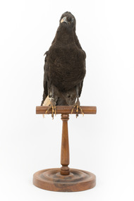 The Beechworth Burke Museum
Animal specimen - American Crow, Trustees of the Australian Museum, 1860-1880
The American Crow is common throughout North America. They reside in areas with open view and trees but can often frequent city parks, suburbs of large cities and along the seashore. The Crow is a robber and therefore, find living in locations which they can raid for food perfect. These birds are sociable animals and are often found in small groups made up of family members. All their lives they reside in the one location; however, they do migrate south during the autumn. They usually find their food by walking along the ground and eat both plant and animal foods. This includes worms, larvae, insects and fruits and nuts. Crows are also known to feed on small rabbits, frogs and mice. They are also identified as nest predators because they feed on eggs. In areas occupied by humans, the Crow will find their food source from trash and also road kill. The American Crow is not considered to be an endangered species and list them on the IUCN Red List as Least Concern. However, large amounts of crows are killed for sporting and during campaigns (having a desire to reduce the population of the Crow in America). This specimen is part of a collection of almost 200 animal specimens that were originally acquired as skins from various institutions across Australia, including the Australian Museum in Sydney and the National Museum of Victoria (known as Museums Victoria since 1983), as well as individuals such as amateur anthropologist Reynell Eveleigh Johns between 1860-1880. These skins were then mounted by members of the Burke Museum Committee and put-on display in the formal space of the Museum’s original exhibition hall where they continue to be on display. This display of taxidermy mounts initially served to instruct visitors to the Burke Museum of the natural world around them, today it serves as an insight into the collecting habits of the 19th century.This specimen is part of a significant and rare taxidermy mount collection in the Burke Museum. This collection is scientifically and culturally important for reminding us of how science continues to shape our understanding of the modern world. They demonstrate a capacity to hold evidence of how Australia’s fauna history existed in the past and are potentially important for future environmental research. This collection continues to be on display in the Museum and has become a key part to interpreting the collecting habits of the 19th century.This American Crow has black plumage which has slightly faded in colour. This colour fading could also indicate that the bird was molting because the feathers of the American Crow appear brownish when the are about to molt and these feathers give way to new glossy black feathers. The specimen has two black glass eyes, a dark bill and dark legs with talons. Both the edges of the bill and the talons are faded into a pale buff colour. It is likely that the legs and talons were painted a dark black by the taxidermist and the paint has either worn off or faded over the years. The bird is standing tall on a wooden mount and looking forwards. It has a paper identification tag attached to the right leg. The tail is short and the feathers are rounded at the ends.153a. / See catalogue page 61taxidermy mount, taxidermy, animalia, burke museum, beechworth, australian museum, skin, reynell eveleigh johns, bird, america, crow, american crow -
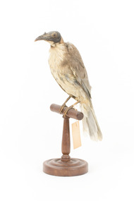 The Beechworth Burke Museum
Animal specimen - Noisy Friarbird, Trustees of the Australian Museum, 1860-1880
... mainly seen in small groups and often active in flowering plants... plants, especially eucalyptus trees. Noisy Friarbirds are found ...The Noisy Friarbird are conspicuous and active Honey-eaters mainly seen in small groups and often active in flowering plants, especially eucalyptus trees. Noisy Friarbirds are found along the east coast of Australia, from north-eastern Queensland to north-eastern Victoria. They often feed in noisy flocks, alongside other Honey-eaters such as the Red Wattlebird. This specimen has been mounted in an accurate, yet stylised fashion. This specimen is part of a collection of almost 200 animal specimens that were originally acquired as skins from various institutions across Australia, including the Australian Museum in Sydney and the National Museum of Victoria (known as Museums Victoria since 1983), as well as individuals such as amateur anthropologist Reynell Eveleigh Johns between 1860-1880. These skins were then mounted by members of the Burke Museum Committee and put-on display in the formal space of the Museum’s original exhibition hall where they continue to be on display. This display of taxidermy mounts initially served to instruct visitors to the Burke Museum of the natural world around them, today it serves as an insight into the collecting habits of the 19th century.This specimen is part of a significant and rare taxidermy mount collection in the Burke Museum. This collection is scientifically and culturally important for reminding us of how science continues to shape our understanding of the modern world. They demonstrate a capacity to hold evidence of how Australia’s fauna history existed in the past and are potentially important for future environmental research. This collection continues to be on display in the Museum and has become a key part to interpreting the collecting habits of the 19th century.The Noisy Friarbird has a characteristically black head which lacks plumage and has a prominent casque (bump) on the base of its strong bill. The specimen has an off-white underbody and neck, a light brown back and tail with a white tip at the end of the tail. This specimen stands upon a wooden platform and has an identification tag tied around its leg.59a / Friarbird / See Catalogue Page 18 /taxidermy mount, taxidermy, animalia, burke museum, beechworth, australian museum, skin, bird, noisy friarbird, friarbird, australian birds, oz animals, wattlebird -
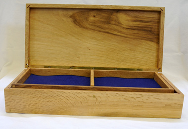 Orbost & District Historical Society
wooden box, McLean, Don, Just prior to January 2010
This box was crafted from a portion of one of the original oak trees in the Jarrahmond WW11 Avenue of Honour.The Avenue was planted in 1955 and linked the farms of the two servicemen from Jarrahmond who lost their lives in WWII. It consisted of English Oaks interspersed with flowering peaches and cherries. Wood for the box was collected in the early 1990's by Stan Weatherall following a windstorm. Stan had the timber rough-sawn into planks by local sawmiller Max Reynolds. The timber was stored for a number of years before being given to Don McLean.A hand-made oak box. The inside base is lined in green felt. The lid is single hinged. the front panel displays a radiating pattern in the grain of the oak wood that resembles the rising sun badge of the Australian Defence Forces. Two brass pins are symbols of Australian military regalia. Inside the box is an envelope with information and letters on the manufacture of the box and presentation to Orbost. The information concerns the Jarrahmond School and the Avenue of Honour.handcraft oak jarrahmond-avenue-of-honour container -
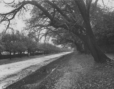 The Beechworth Burke Museum
Photograph
This photograph was taken of an avenuw of acacias on Sydney Rd, Beechworth. Picture on the left hand-side is a row of Liquidamber trees also known as American storax, hazel pine, bilsted, redgum, satin-walnut, star-leaved gum, alligatorwood, or simply sweetgum. On the right is a row of English Oak trees commonly known as common oak, pedunculate oak, or European oak. Behind the English oaks is Old Beechworth Goal. Many of the trees in the Beechworth township were planted in the 1860's and today have exceptional historical, botanical or cultural value. Their place within the built environment reflects the importance in the Victorian era of town planning for a community, wealthy in gold and civic pride.Black and white rectangular photograph. The image is printed on gloss photographic paper and mounted on cardboard. Obverse: NO INSCRIPTION Reverse: 7760 The old Acacia Avenue alongside the jail. Sydney Road Beechworth Gardens & Parks beechworth, acacia avenue, gaol, sydney road, burke museum, photograph, post card, english oak, liquidambar -
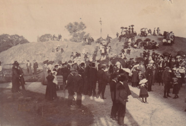 The Beechworth Burke Museum
Photograph, c. 1902
... collection of historic trees and plants, which have been listed ...Taken in c. 1902, depicted is a group of adults and children dressed in formal clothing, with some of the women in the crowd carrying parasols, standing and sitting around and upon the rock at Queen Victoria Park on the Ford Street side of the park. This group is celebrating the official opening of the park. On top of the rock is a gas lamp post.Originally known as the Beechworth Botanical Gardens, the Queen Victoria Park features a extensive collection of historic trees and plants, which have been listed on the Indigo Shire’s Significant Tree Register. Sepia rectangular photograph printed on matte photographic paperReverse: 3716 (in black pen)/ 97.2273 (in pencil)/entertainment album, beechworth, queen victoria park, gardens & parks, opening, burke museum -
 The Beechworth Burke Museum
Photograph, c. 1905
... Park features a extensive collection of historic trees ...Taken in c. 1905, depicted is a large group of children and adults dressed in formal attire sitting and standing upon a granite rock that is located in the centre of Queen Victoria Park. In front of the group is a wooden picket wire fence that sides the granite rock. On top of the rock is a gas lamp post.Originally known as the Beechworth Botanical Gardens, the Queen Victoria Park features a extensive collection of historic trees and plants, which have been listed on the Indigo Shire’s Significant Tree Register.Black and white rectangular reproduced photograph printed on matte photographic paperReverse: 6956 (in pencil)/ ©/ DONALD HAYES/ BEECHWORTH (stamped in orange ink)/entertainment album, burke museum, beechworth, queen victoria park, park -
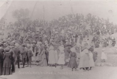 The Beechworth Burke Museum
Postcard, c. 1903
... features a extensive collection of historic trees and plants, which ...Taken in c. 1903, depicted is a large group of adults and children dressed in formal attire gathered around and upon the granite rock in the centre of Queen Victoria Park.Originally known as the Beechworth Botanical Gardens, Queen Victoria Park features a extensive collection of historic trees and plants, which have been listed on the Indigo Shire’s Significant Tree Register.Black and white rectangular postcard printed on cardObverse: QUEEN'S ROCK VICTORIA PARK BEECHWORTH Reverse: 3701/ 3641 (this has been crossed out)/ Parks & Gardens/ 1998.00059/ entertainment album, burke museum, beechworth, queen victoria park, gardens & parks -
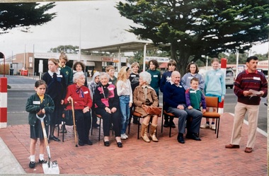 Phillip Island and District Historical Society Inc.
Photograph, Centennial planting of trees in Cowes 1994
... Centennial planting of golden cyprus trees in Thompson...Centennial planting of trees at Cowes. Seniors - Edna... Matthew Wright Centennial planting of trees at Cowes. Seniors ...Centennial planting of golden cyprus trees in Thompson Avenue, Cowes. 2/9/1994. Megan Fuller was grand daughter of Min Lawrence, Matthew Wright was great grandson of Peter ForrestHistorical Coloured photo of people sitting and standing on path in Cowes. 4 guests seated and 1 official standing. Group of schoolchildren behind them. One girl with spade at front left. Also 4 strips of negatives [ 13 photos] taken at the same function.Centennial planting of trees at Cowes. Seniors - Edna Thompson, Min Lawrence, Isa Niven, Peter Forrest & grandchildrengolden cyprus trees, centennial, edna thompson, min lawrence, isa niven, megan fuller, peter fuller, matthew wright -
 Bendigo Military Museum
Container - BOX - METAL
Ornamental brass box of unknown use. Item in the collection of "Richard William McGILVERY" RAAF. Refer Cat No. 7287P for his service details, photo and awards.Silver metal box with separate lid. Lid has inlays of Japanese scenery of antelope, tree, buuildings. Mostly gold colour but with red plants. Centre of lid has hole cut into it.ornamental box, bcof -
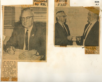 Bendigo Military Museum
Mixed media - SCRAPBOOK BENDIGO RSL, C. 1967 - 1972
... and article re planting a Lone Pine tree. Page 9. Two articles and two.... Phot and article 1969 re the planting of an Aleppo Pine tree ...This is the 2nd set of 6 pages from Scrap book Cat No 8225. Page 7a. Photo and article re Sam Ryan receiving a Life Membership of the RSL. Refer Cat No 8225. Page 7b. Photo and Article of Sam Ryan President Bendigo RSL receiving a cheque from Mr W.P. Casey Chairman of Directors of the Bendigo Easter Fair. Page 8. Phot and article 1969 re the planting of an Aleppo Pine tree from the original on Gallipoli. On the Left is Jack Plant President Bendigo RSL, the other two persons unknown as section of the text is missing. Page 9a. Anzac Appeal 1969, Mr John Ogden pins an Anzac token on the coat of Phillip Rice. Page 9b. From the "Mufti" RSL Magazine showing Delegates to the RSL State Conference 1969. Three of the six are known, W.B. Nicholls, D.J. Osborn, J. Hipworth State Councillor. Page 9c & d. Jack PLant in both photos on the left, other man unknown as well as place. Page 10. From the bendigo Advertiser relating to the Bendigo RSL Annual Dinner held on Saturday 10th 1971. From the left is G. Garth President Kangaroo Flat RSL, Lt Col W. Howarth Commanding Officer AHQ Survey Regiment, T. Shaw State Executive of the RSL, J Plant President Bendigo RSL, T Stephens Deputy Commissioner Repatriation Department and Cr N.J. Oliver the Mayor of Bendigo. Page 11a. Photo from a Bendigo RSL Annual Dinner year unknown, 2nd from the left is Bruce Ruxton State President of the Victorian RSL, 2nd from the right is possibly W.B. Nicholls, others onknown. Page 11b. This is a photo of RSL Annual Dinner 1971, same as per Page 10 for details. Page 12. Photograph of Bendigo RSL Annual Dinner year unknown. 2nd from the left is Jack Plant, the man to the left of man standing is possibly W. Howarth CO Survey Regiment.Six articles and Spiroflex sketch book. Page 7. Photo and article re the award of a Life Membership. Page 8. Photo and article re planting a Lone Pine tree. Page 9. Two articles and two photos re Appeals and State Conference. Page 10. Photo and article re RSL Annual Dinner. Page 11. Two photos re RSL Annual Dinners. Page 12. One photo re RSL Annual Dinner. Page 8 hand written, "1969". Page 9, hand written names as per "Context"brsl, smirsl, scrapbook -
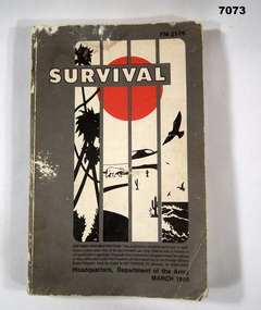 Bendigo Military Museum
Book, US Army, Survival, 1986
Item in the collection re Craig Triffett. Refer Cat No 5997.5 for his service details.This is a paperback book. Front cover has grey background. In the centre are images of palm trees, bear, birds, desert and oceans. A Red sun is at top of page. At bottom of front page is USA distribution regulations. It has 16 plus chapters on how to survive plus Annexes A-G. It has written text, numerous diagrams, and colour photos of plants and snakes.book, survival -
 Eltham District Historical Society Inc
Photograph, Peter Pidgeon, Avenue of Honour, Main Road, Eltham, 2 Aug. 2022
... -1917 by the Welcome Home Committee with the planting of over...-1917 by the Welcome Home Committee with the planting of over ...View looking up Main Road and the Avenue of Honour from opposite Dalton Street. The former Jarrold Cottage and Bootmakers shop on left. The Avenue of Honour was established in 1916-1917 by the Welcome Home Committee with the planting of over 100 trees dedicyted to the eternal memory of soldiers from the Eltham district who served in the First World War (1914-1918). Comparison photo: 00533 Part of a presentation by Peter Pidgeon to the Society, 13 August 2022 showcasing a series of photographs taken by John Henry Clark over the period 1895 to 1930. John Henry Clark was the youngest of three boys born to William Henry Clark (1823-1877) and Maria White (1843-1914). He and his brothers, William Charles Clark (1872-1945), Clement Kent Clark (1874-1912) operated a photography business (Clark Bros.) from 25 Thomas Street, Windsor near Prahran during the period c.1894 to 1914. Following death of Clement in September 1912 and their mother in 1914, the Clark Bros business appears to have dissolved, the premises demolished, and a new house was under construction in 1915. John set up business independently in 1914 operating out of 29 Moor Street, Fitzroy where he is registered in the 1914 and 1915 Electoral Rolls. By 1916 John had relocated to Eltham where he continued his practice as a photographer and took many of the early images around the district of Little Eltham. Around 1930 John changed professions and opened a small cobbler's shop in 1931 near the pond opposite Dalton Street adjacent to the Jarrold family cottage. He never married and continued his profession as a bootmaker from this little shop, maintaining a close relationship with Mrs Jarrold for the rest of their lives. His bootmaker shop remains today beside the Whitecloud cottage and is one of only three remaining shops in the area from the early 20th century.Comparative photo taken 2022 with one taken from same location over 100 years earlier by noted local photographer J.H. ClarkBorn Digitaleltham, j.h. clark photo (2022), dalton street, main road, bootmaker's shop, jarrold cottage, white cloud cottage, avenue of honour -
 Eltham District Historical Society Inc
Photograph, Peter Pidgeon, Avenue of Honour, Main Road, Eltham, 2 Aug. 2022
... by the Welcome Home Committee with the planting of over 100 trees... by the Welcome Home Committee with the planting of over 100 trees ...View looking down Main Road and the Avenue of Honour from Brougham Street. The Avenue of Honour was established in 1916-1917 by the Welcome Home Committee with the planting of over 100 trees dedicyted to the eternal memory of soldiers from the Eltham district who served in the First World War (1914-1918). Comparison photo: SEPP_0748 Part of a presentation by Peter Pidgeon to the Society, 13 August 2022 showcasing a series of photographs taken by John Henry Clark over the period 1895 to 1930. John Henry Clark was the youngest of three boys born to William Henry Clark (1823-1877) and Maria White (1843-1914). He and his brothers, William Charles Clark (1872-1945), Clement Kent Clark (1874-1912) operated a photography business (Clark Bros.) from 25 Thomas Street, Windsor near Prahran during the period c.1894 to 1914. Following death of Clement in September 1912 and their mother in 1914, the Clark Bros business appears to have dissolved, the premises demolished, and a new house was under construction in 1915. John set up business independently in 1914 operating out of 29 Moor Street, Fitzroy where he is registered in the 1914 and 1915 Electoral Rolls. By 1916 John had relocated to Eltham where he continued his practice as a photographer and took many of the early images around the district of Little Eltham. Around 1930 John changed professions and opened a small cobbler's shop in 1931 near the pond opposite Dalton Street adjacent to the Jarrold family cottage. He never married and continued his profession as a bootmaker from this little shop, maintaining a close relationship with Mrs Jarrold for the rest of their lives. His bootmaker shop remains today beside the Whitecloud cottage and is one of only three remaining shops in the area from the early 20th century.Comparative photo taken 2022 with one taken from same location over 100 years earlier by noted local photographer J.H. ClarkBorn Digitaleltham, j.h. clark photo (2022), main road, avenue of honour -
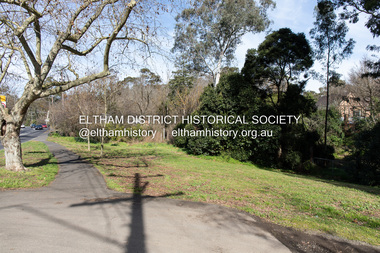 Eltham District Historical Society Inc
Photograph, Peter Pidgeon, Avenue of Honour, Main Road, Eltham, 2 Aug. 2022
... in 1916-1917 by the Welcome Home Committee with the planting... in 1916-1917 by the Welcome Home Committee with the planting ...View looking down Main Road and the Avenue of Honour from near Brougham Street. The Avenue of Honour was established in 1916-1917 by the Welcome Home Committee with the planting of over 100 trees dedicyted to the eternal memory of soldiers from the Eltham district who served in the First World War (1914-1918).Born Digitaleltham, main road, avenue of honour