Showing 176535 items
matching will street
-
 Glenelg Shire Council Cultural Collection
Photograph - Photograph - Bentinck and Julia Streets, Portland Victoria, n.d
Black and white photo of Bentinck St, corner of Julia St, looking south. London Hotel on corner, Gordon and Mac's Hotels visible. Cypress pines on right, single horse and dray in street.Back: '12' 'Bentinck Street, Portland (looking south) ' handwritten, black pen -
 Kew Historical Society Inc
Plan - Subdivision Plan, J R Mathers & McMillan, Normanby Estate, c.1913
The Kew Historical Society's map collection includes a substantial number of real estate subdivision plans, mainly of Kew but also of surrounding suburbs in Melbourne. Most of the subdivision plans date from the 1920s and 1930s when the districts old homes and local farmland were being split up to accommodate residential growth in the postwar period. These early plans were assembled by a local firm, Jas R Mather & McMillan, which had an office in Cotham Road. Many of the plans, and sometimes photos, were annotated by the agents.Subdivision plans are historically important documents used as evidence for the growth of suburbs in Australia. They frequently provide information about when the land was sold as well as evidence relating to surveyors and real estate and financial agents. The numerous subdivision plans in the Kew Historical Society's collection represent working documents, ranging from the initial sketches made in planning a subdivision to printed plans on which auctioneers or agents listed the prices for which individual lots were sold. In a number of cases, the reverse of a subdivision plan in the collection includes a photograph of a house that was also for sale by the agent. These photographs provide significant heritage information relating house design and decoration, fencing and household gardens.The photograph may also be aesthetically significant depending on the importance of the photographic atelier.The Normanby Estate, which was adjacent to Normanby Road, Kew East, included thirty-one lots for sale. Streets on the subdivision plan include Adeney Avenue, Park Hill Road, Normanby Road, Weir Street and Wharton Street. Cotham Road and its tramway are shown nearby. The plan is interesting as it shows Wharton Street, named after the architect and town planner George Wharton, who was the first chairman of the Municipality of Kew. The street was to later be renamed Cecil Street. Also shown are proposed ‘Municipal Gardens’ where Parkhill Drive is now located."D" in top left corner. Stamped auctioneers contact details: "Jas. R. Mathers & Son & McMillan / Auctioneer & Land Salesmen, / 271 Collins Street / Melbourne" and Jas. R. Mathers / Estate & Financial Agent / Cotham Road / Kew".weir street - kew, wharton street - kew, normanby road - kew, cotham road - kew, municipal gardens - kew, park hill parkhill road - kew, braemar - kew, subdivision plans - kew -
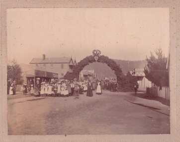 Clunes Museum
Photograph
UNIDENTIFIED PHOTOGRAPH DONATED BY W. GAYFORD, 20 WOLSLEY STREET, MONT ALBERTBLACK AND WHITE PHOTOGRAPH STREET PARADElocal history, photography, photograph, events and celebrations -
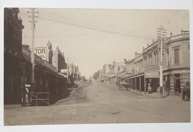 Kew Historical Society Inc
Photograph, High Street, Kew, 1891
Early photograph of High Street, Kew, looking east from Kew Junction.High Street, Kew, circa 1891.high street, kew, kew junction, streets -- kew (vic) -
Bendigo Historical Society Inc.
Book - BORONIA BABIES, MAY GIBBS
Book, ''Boronia Babies'', May Gibbs .A selection of short stories , Angus & Robertson Ltd, Sydney. W.C.Penfold & Co Printers 183 Pitt Street Sydney. Stamp of R.H.S.of Victoria,Bendigo Branch on front page & last page.''To Elma with love and best wishes'' inscibed on first page.W.C.Penfold & Co., Printers, 183 Pitt Street , Sydney.book, boronia babies, may gibbs. -
Whitehorse Historical Society Inc.
Map, Subdivision Plan for part of Blackburn Park, c1910
Photocopy of advertisement for sale of subdivision of area in BlackburnPhotocopy of advertisement for sale of subdivision of area in Blackburn between the railway line and Whitehorse Road between Station Street and Alfred Street. Some purchasers noted between 1903 - 1912.Photocopy of advertisement for sale of subdivision of area in Blackburnland subdivision, whitehorse road, blackburn, station street, blackburn, railway road, blackburn, queen street, blackburn, albert street, blackburn, chapel street, blackburn, george street, blackburn, cottage street, blackburn, alfred street, blackburn -
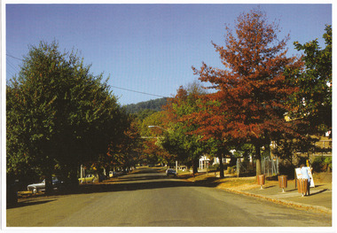 Marysville & District Historical Society
Photograph (Item) - Colour photograph, 04-1982
A colour photograph of Murchison Street in Marysville in Victoria.A colour photograph of Murchison Street in Marysville in Victoria.MARYSVILLE - APRIL 1982murchison street, marysville, victoria, photograph -
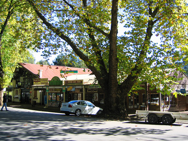 Marysville & District Historical Society
Photograph (Item) - Colour photograph, Travel Victoria, 2006
A colour photograph of Murchison Street in Marysville in Victoria.A colour photograph of Murchison Street in Marysville in Victoria. The buildings along Murchison Street were destroyed in the 2009 Black Saturday bushfires.murchison street, marysville, victoria, photograph, 2009 black saturday bushfires -
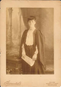 Bendigo Historical Society Inc.
Photograph - FEMALE PORTRAIT: ACADEMIC, 1906
Sepia studio photo. Woman wearing academic regalia, pincenez, ring on 4th. L.H. finger. Figure holds sheet music in both hands. Cane table at figure's right. Studio view in background. Printed in script 'Stewart and Co. Printed in capitals '284 - 286 Bourke Street, Melbourne'at bottom left. Writtyen back"Mr and Mrs Dowsey. With fond love from Auntie May. 19.11.06Stewart and Co., Bourke Street, melbourneperson, individual, female - academic -
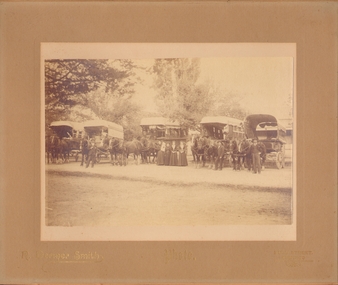 Bendigo Historical Society Inc.
Photograph - C.BUTTON, BENDIGO
Sepia photograph, outside. Large trees in b/ground. 5 covered horses. Drawn wagons with curtains. At centre, 4 females, one holding a child, dressed in white, 3 men standing by horses heads, 2 figures are seated in centre wagon. Wagons at centre + R marked 'C.Button, Bendigo' (C maybe Chas). Inscription: On Front Bottom, 'R.Dermer Smith. Photo. Bull Street/Bendigo'R.Dermer Smith. Bull Street Bendigocottage, miners -
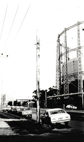 Port Melbourne Historical & Preservation Society
Photograph - Graham Street towards Albert Park, Reverend Donald LANGFORD, June 1973
Taken from the corner of Seisman Place looking towards Albert Park, the photograph was taken before the demolition of the gasometer shown on the on right. The original Albert Park High School can be seen behind the Pickles Street sign.B & W photograph of Graham Street, Port Melbourne looking towards Pickles Street.built environment - demolition, built environment - industrial, transport - roads, education - secondary schools, gasometer -
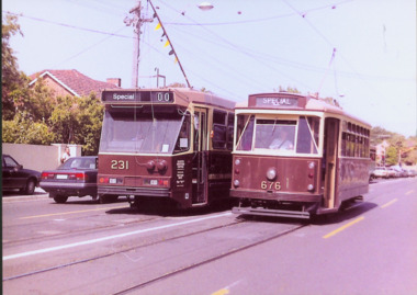 Kew Historical Society Inc
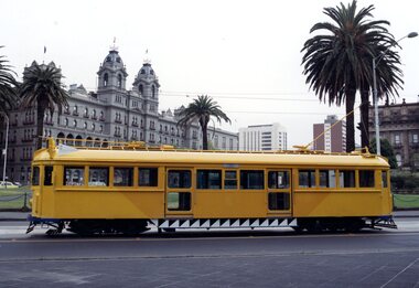
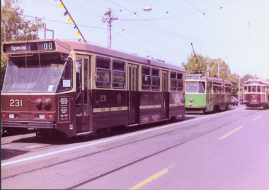
Photograph - Class A 231 & X2 Class 676 in High Street South, 1990
This colour photograph, with 15 others are enlargements gifted to the Society by Mel Lawrence in 2016. They were taken at a commemorative event from the Kew Tram Depot. Laminated colour enlargement of a Class A 231 & X2 Class 676 in High Street South taken at a re-enactment from the Kew Depot in 1990.Annotation reverse: "Kew Depot 1990. Class A 231 & X2 Class 676 in High Street South"kew tram depot, class a trams - melbourne, x2 class trams - melbourne -
 Stawell Historical Society Inc
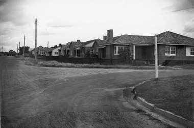
Photograph, Housing Commission House in Dawson Street -- Photo & Newspaper Clipping
The first Housing Commission homes of brick and tiled roof built after WW2 in Stawell Dawson Street c 1950's. Also in the file a Newspaper clipping from News, Saturday, October 11. 1947. "George Mitchell Square" the first Housing Commission homes built in Stawell. George Mitchell was a member of Borough Council for 40 years and Mayor for 4 years. The housing estate was named in his honor. The architects "Buchannan Laird & Buchanan Geelong.Black and white photograph of a street scene. The photograph shows a line of brick houses along the street with timber fences. Four electric power lines are along the street with 2 in the distance. The street also has curb and guttering. The street to the right has a street post with "George Mitchell St" written on the street sign.stawell -
 Melbourne Tram Museum
Photograph - SW5.758 on Macarthur Street, Michael McLeod, c. 1980s
Photograph shows SW5 No. 758 on Macarthur Street. Trolley poles are visible and in use. The Hotel Windsor in Spring Street is visible in the background. The tram is painted in a livery of the Transporting Art program, as a so-called "Art Tram." The artwork is by Michael Johnson, sponsored by the State Insurance Office. Photo by Michael McLeod.Shows a now-withdrawn tram with obsolete equipment (i.e., trolley poles) and livery representing a culturally important event in Melbourne's transit history.Colour Photograph - SW5.758 on Macarthur Streettrams, tramways, sw5 class, art trams, transporting art, public transport, tram 758 -
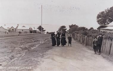
 Phillip Island and District Historical Society Inc.
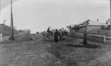
Photograph, Main Street, Cowes
Building on the right is Robb Brothers StoreCopy of a sepia photo of Main Street,[Thompson Ave] Cowes, showing dirt road with buildings on the right side.Looking south uphill along Thompson Ave. A man on a jinker on road talking to 2 women and another woman standing on right side of road.Main Street [Thompson Ave] Cowes. Robb Bros Storecowes, thompson avenue cowes, photographs, transport - jinker, robb brothers -
 Kew Historical Society Inc
Photograph - A Class 231, Y1 Class B11 & W2 Class 380 in High Street South, 1990
This colour photograph, with 15 others are enlargements gifted to the Society by Mel Lawrence in 2016. They were taken at a commemorative event from the Kew Tram Depot. Laminated colour enlargement of trams in High Street South during a re-enactment from the Kew Depot in 1990.Annotation reverse: "Kew Depot 1990. A Class 231, Y1 Class, B11 & W2 Class 380 in High Street South"kew tram depot, a class trams, trams -- melbourne, y1 class trams, w2 class trams -
 Marysville & District Historical Society
Photograph (Item) - Colour photograph, Unknown
A colour photograph of Murchison Street in Marysville in Victoria.A colour photograph of Murchison Street in Marysville in Victoria.murchison street, marysville, victoria, photograph -
 Marysville & District Historical Society
Photograph (Item) - Colour photograph, Unknown
A colour photograph of Murchison Street in Marysville in Victoria.A colour photograph of Murchison Street in Marysville in Victoria.murchison street, marysville, victoria, photograph -
 Uniting Church Archives - Synod of Victoria
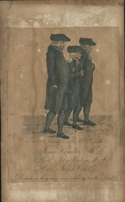
Printed etching, Undated c.1790
James Hamilton (1740-1827) joined the fledgling Methodist society and became a local preacher. He helped John Wesley to organise Methodism in Scotland. He became an influential member at Wesley's Chapel in City Road London. John Wesley 1703-1791 was the founder of Methodism.Printed etching mounted on timber. Depicts 3 men in profile view as they walk down the street.1. James Hamilton M.D. 2. Revd. John Wesley M.A. 3. Revd. Joseph Cole Drawn as they were seen walking in the Streetjames hamilton, rev john wesley, rev joseph cole, methodist -
Stawell Historical Society Inc
Realia, Heslop's Ash Tray, 1970'2
Advertising for electrical Shop on the corner of Main Street and Victoria PlaceClear Glass ash tray marked for Advertising: Compliments of Heslop's BP. Fuels - Lubricants Heslop Electrics149 151 Main Street Stawell Phone 51803advertising smoking -
![[Section] Drawing room ceiling , 'Villa Alba', Walmer Street (Kew)](/media/collectors/550653872162f11fb04854aa/items/658d13590f23e8f1e738caea/item-media/658d13c20f23e8f1e738ce30/item-fit-380x285.jpg) Kew Historical Society Inc
Kew Historical Society IncPhotograph - Drawing room ceiling , 'Villa Alba', Walmer Street (Kew), c. 1965
"Villa Alba is of significance for the outstanding late Victorian painted decoration throughout its interior. The consistently high standard of design in the decoration, and high, and at times, superb quality of its execution, the variety of illustrative techniques, the variety of illusionist effects and the hierarchy of treatments between the rooms of the house all contribute to the significance. The decorative scheme is also of significance as a fine example of the work of the leading Melbourne decorators, the Paterson Brothers. It is one of their first interiors to depart totally from the use of pre-prepared wallpapers of repetitive designs and it is a rare and comprehensive extant example of their domestic work. The decorative schemes in the ground floor hall, the dining room, the drawing, the vestibule, the stair hall, the upper hall, bedroom 1 and the boudoir are also individually of significance as outstanding examples of Victorian decoration.." (Victorian Heritage Database, 2023)This work forms part of the collection assembled by the historian Dorothy Rogers (1905-1973), donated to the Kew Historical Society by her son in 2015. The manuscripts, photographs, maps, and documents were sourced by her from both family and local collections or produced as references for her print publications. Many were directly used by Rogers in writing ‘Lovely Old Homes of Kew’ (1961) and 'A History of Kew' (1973), or the numerous articles on local history that she produced for suburban newspapers. Most of the photographs in the collection include detailed annotations in her hand. The Rogers Collection provides a comprehensive insight into the working habits of a historian from the 1960s to the 1970s. Original print monochrome photograph of a section of the drawing room ceiling in 'Villa Alba', Walmer Street (Kew)Annotation on reverse: "Villa Alba ceilings. [Stamp - The Royal Women's Hospital, 212 Cardigan Street, Carlton. With Compliments of Public Relations Office]"dorothy rogers, villa alba museum, paterson bros, interior decoration -- 1880s -
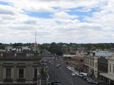 Ballarat Heritage Services
Photograph - Photograph - Colour, Ballarat From the Regent Cinema, Lydiard Street North, Ballarat, 2015, 27/12/2016
Lydiard Street is known as an axcellent example of Victorian architecture.Various views of Ballarat's Lydiard Street Northballarat, lydiard street north, buildings, aerial, birds eye, sebastions, regent cinema -
 Phillip Island and District Historical Society Inc.
Photograph, Cowes Phillip Island, 1920
A stretch of the main Street of Cowes, looking towards Westernport Bay. A narrow strip of the Peninsula in the background. Left side of road depicts a group of buildings and Post Office. A Norfolk Pine in the background. On right side of road on footpath are three women and a child. The women are attired in long black dresses and large smart hats. Along side them is a picket fence, shrubby garden and a house. A small child and male figure popping out the gate.Thompson Avenue, CowesMain Street Coweslocal history, photographs, streetscape, cowes, black & white photograph, mary robb -
 Tatura Irrigation & Wartime Camps Museum
Photograph, Westpac, Hogan Street, Tatura
Shows picture of businesses looking east down Hogan street towards the Clock Tower intersection, Hogan Street, Tatura. Colour photograph showing businesses looking east down Hogan Street towards where the Clock Tower is located in Hogan Street, Tatura. Photograph stuck onto piece of white cardboard. hogan street tatura, criterion hotel tatura, westpac tatura, chemmart tatura, maskell real estate tatura, middle cafe tatura -
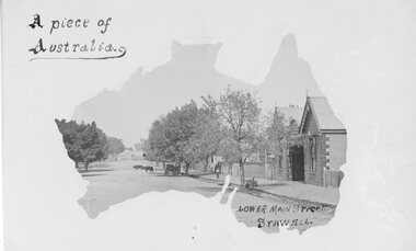 Stawell Historical Society Inc
Postcard, Railway Hotel in Lower Main Street Stawell c1900 -- Postcard
Postcard with Australia outline Wooden Railway Hotel Lower Main Street Stawell c1900 with Cattle on roadway near rail crossing. By the "Merle Studio" Main Street Stawell.Postcard with Australia outline Wooden Railway Hotel Lower Main Street Stawell c1900 with Cattle on roadway near rail crossing. By the "Merle Studio" Main Street Stawell.stawell -
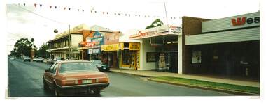
 Surrey Hills Historical Society Collection
Book, City of Whitehorse Heritage Review (as it relates to Surrey Hills), 1999
A street by street survey of each of the proposed precincts was undertaken. For each precinct, building fabric was defined in terms of intactness, scale, construction type, architect and predominant eras of construction.A street by street survey of each of the proposed precincts was undertaken. For each precinct, building fabric was defined in terms of intactness, scale, construction type, architect and predominant eras of construction.cultural property, protection of historic sites, heritage overlay precincts, heritage review, building citations -
 Port Melbourne Historical & Preservation Society
Photograph - Launch of History of a Street Precinct, 25 Sep
In 2005, members of the PMH&PS undertook a study of the residents of the houses in a Port Melbourne street precinct from the 1880s to 1960. The area is bounded by Evans Street, the E side of Bridge Street, S side of Williamstown Road, Farrell Street both the E & W sides plus the section of Ross Street between Farrell and Bridge and the part of Derham Street between Farrell and Bridge. The resulting map and an interactive CD won the Best Community Research, Registers & Records project at the 2007 Victorian Community History Awards. The project was launched on the railway reserve near the corner of Evans & Farrell streets. LL - R - unknown, Pat GRAINGER, Graham BRIDE.Pat GRAINGER, Graham BRIDE at the launch of the History of a Street Precinct project. 25/9/05 Not Known, Pat Grainger, Graham Bridepat grainger, graham bride, history of a street precinct -
 Linton and District Historical Society Inc
Photograph, Patrick O'Sullivan's Saddlery, Sussex Street, Linton circa 1930-1940, Copy of original photograph, made 2010
This scanned and labelled image has been copied from an original image lent from the LDHS collection in June 2001; copied by John O'Sullivan, the great grandson of Patrick and Ellen O'Sullivan.Black and white photograph of O'Sullivan's saddlery/harness-maker shop in Sussex Street, Linton. Photograph is believed to have been taken during the 1930s or 1940s (dated by Bennett home next to the saddlery, which was built around 1928)."Patrick O'Sullivan's Saddlery, Sussex Street, Linton c.1930-1940s".patrick o'sullivan, ellen o'sullivan, john o'sullivan, saddlers, sussex street linton -
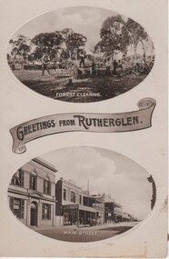 Rutherglen Historical Society
Image, Greetings from Rutherglen, 1910 to 1912
Black and white postcard with two oval photographs with "Greetings from Rutherglen" on a banner between them. The top photograph is of workmen cutting down trees. The bottom one is a view of Main Street looking west.At bottom of top photograph: "Forest Clearing." At bottom of bottom photograph: "Main Street."land clearing, timber felling, main street, bank of australasia, s younkman & co, victoria hotel -
 Melton City Libraries
Photograph, Melton Court House, Unknown
The Melton Court House constructed in 1892 and operated for nearly 100 years. It is one of only two early buildings remaining in Melton's main shopping street, and the only nineteenth century building in the street. It has been converted into the visitor centre and cafe.Melton Court House, High Street Meltonlocal architecture