Showing 17492 items
matching plenty-hotel
-
 Tarnagulla History Archive
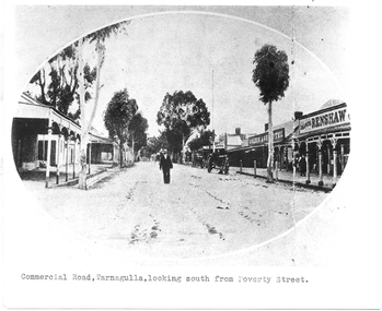
Photograph of Commercial Road, Tarnagulla looking south from Poverty Street, Commercial Road, Tarnagulla Looking South from Poverty Street, January 1907, at the time of the Poseidon Gold Rush, circa 1890 - 1900
Murray Comrie Collection. This is a reasonable copy of an older original. Copy probably made by Murray Comrie in the 1970s. Monochrome photograph. View of Commercial Road Tarnagulla looking south. A man at centre, walking toward camera. Right of this figure are two carts standing at the road's edge. Far right is Renshaw's Drapery and left of that the Golden Age Hotel. A man is walking along the footpath in front of Renshaw's. Typed caption on original is 'Commercial Road, Tarnagulla, looking south from Poverty Street'.tarnagulla, commerce, stores, shopping, shops, draper, hotels, golden age hotel, buildings, commercial road, main street -
 Tarnagulla History Archive
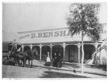
Photograph of Renshaw's Victoria House Store, Tarnagulla, 1890-1916
Murray Comrie Collection. Murray Comrie's information about Renshaw's to be added. This photograph is a dark copy probably created from an older original.Monochrome photograph of people outside Renshaw's Store in Tarnagulla. Three women standing on curb and a man standing on wagon with two harnessed horses. The woman in the middle is Mary Renshaw, and she is surrounded by her daughters. The gable roof of the Golden Age Hotel can be seen dimly on the left.tarnagulla, renshaw's, renshaws, renshaw, shops, businesses, commercial road -
 Wodonga & District Historical Society Inc
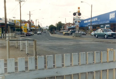
Photograph - Codling Collection 01 - High Street Wodonga looking north from the railway crossing, 1987
Miss Olive Codling was a Foundation Member and a Life Member of the Wodonga Historical Society. Many of her prize-winning photos are held in the Society Collection. She also held a range of roles and committee positions in a wide range of Wodonga community organisations. These included the Horticultural Society, the Wodonga Arts Council, the Wodonga Camera Club and the Wodonga Lapidary Club. This photo collection is significant as it documents how the businesses and buildings in Wodonga have evolved and contributed to community throughout the 20th century.High Street Wodonga looking north from the railway crossing. Railway crossing lights and fence in the foreground. Businesses include Wodonga Shopping Centre Pty Ltd, Lunn & Fordyce and Manns on the right. The Terminus hotel can be seen on the left. This photo was taken for Heritage Week 1987.wodonga businesses, high st wodonga, railway crossing, manns, lunn & fordyce -
 Lakes Entrance Historical Society
Photograph, Holding M, 2005
Date made August 2005Colour photograph showing Central Hotel, taken from Mechanic Street. Covered seating area and outside furniture in Sports Bar, and glimpsed on right hand side driveway for the drive-in bottle shop. Taken from outside of highway showing all lanes. Lakes Entrance Victoriahotels, architecture -
 Port Melbourne Historical & Preservation Society
Legal Record - Affidavit, Missing licence, Foresters Arms Hotel, Dec 1885
.01 Affidavit (handwritten on pale blue printed legal form) and .02 'The Eighth Schedule' (handwritten on poor paper, stained and insect damaged) regarding missing licence during transfer of the Foresters Arms Hotel licence from Thomas De Gruchy to Henry Charles Sansom, 18852built environment - commercial, foresters arms hotel, business and traders - hotels, thomas degruchy, henry charles sansom -
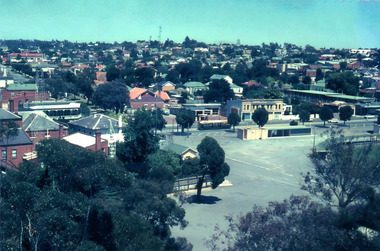 Bendigo Historical Society Inc.
Photograph - ROY J MITCHELL COLLECTION: VIEW FROM LOOKOUT TOWER, QUEEN ELIZABETH OVAL, BENDIGO
Colour photograph taken from lookout tower, Queen Elizabeth Oval, Bendigo, looking southeast. Rifle Brigade Hotel on extreme RH side, carpark behind Art Gallery complex in centre of image. Written on back :'January 1972, Bendigo, Victoria. From Lookout Tower'Roy J Mitchellbendigo, streetscape, queen elizabeth oval -
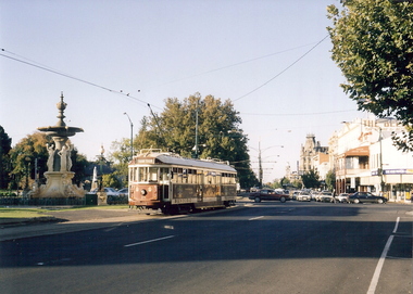 Bendigo Historical Society Inc.
Photograph - CHARING CROSS Bendigo, c2001
Color photograph. Taken from Charing Cross looking back down Pall Mall. Bendigo Tram, Alexandra Fountain, Queen Victoria behind fountain, Shamrock Hotel down Pall Mall, The Behive sign is also visible on the side of the Behive store. Taken April 2001.Willa, Wenybendigo, charing cross, gordon & wendy willa, alexandra fountain, queen victoria, pall mall, shamrock, streetscape -
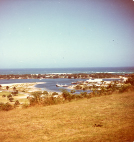 Lakes Entrance Historical Society
Photograph - Bullock Island, Fraser Ian, 1975c
Color photograph of the eastern part of Bullock Island, showing buildings of Lakes Entrance Fishing Co-Operative and PWD, spit opposite Club Hotel has been sown with grass, hummocks and Bass Strait in distance. Taken from Seaview Parade Kalimna. Lakes Entrance Victoriawaterways, islands, land reclamation, topography -
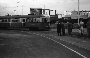 Melbourne Tram Museum
Negative, Wal Jack, 25/06/1955 12:00:00 AM
Black and white negative, by Wal Jack, of PCC 980 in the yard at East Preston depot during the AETA tour of 25/6/1955. The tram has the AETA sign board promoting electric traction. In the background is a advertisement for Goodyear Tyres and Gowerville Hotel advertising Fosters Lager.trams, tramways, aeta, tours, tram 980, pcc class, east preston depot, mmtb -
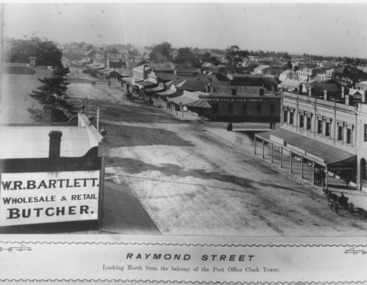 Lakes Entrance Historical Society
Photograph, Caire, Nicholas John, Raymond Street Sale Victoria c1905, 1905c
Raymond Street, looking north from the balcony of the Post Office Clock Tower.Black and white photograph of Raymond Street, showing Bartletts Butcher Shop in foreground and the view looking north down Raymond Street with the fun streetscape in full view and many other shops, including Feilchenfelds Store, W.Puttick - Tailor, and the Albion Hotel. The verandas are a feature. Sale Victoriaroads and streets, architecture, retail trade -
 Clunes Museum
Photograph, BEAUCHAMP PHOTOGRAPHY, CLUNES, C 1881
SEPIA PHOTOGRAPH OF CLUNES TOWNSHIP, TAKEN FROM ANGUS STREET HILL, LOOKING SOUTH; BUILDINGS INCLUDE WESLEY CHURCH, TOWN HALL, CATHOLIC CHURCH, C. OF E. CHURCH; CLUB HOTEL AND BANKS IN FRASER STREET; LIBRARY, FIRE BRIGADE BELL TOWER - FAR RIGHT.photographs, clunes township -
 Wooragee Landcare Group
Photograph, 5 September 2004
This photograph was taken at Tatong Tavern, Victoria on Sunday the 5th of September as part of a day trip by the Wooragee Landcare Group. The event was about looking at land use on small farms and as a social get-together for the Group. Wooragee was also researching how small landholders could run some enterprises around the time of the trip. This photograph includes Jo Luisi, Bob Bennet, Christine Stewart, and Julius Holt. Tatong Tavern was built in the 1880's as Tatong Hotel or 'Pub' hotel for Mr. William Worrall. The original hotel was destroyed in 1923 by a fire, but was rebuilt for Mr. M. C. Clarke. The building is a representation of the changing society, as it changes as its uses and visitors change. The photograph shows the beer garden, which has been added more recently. The Tavern has a bar, restaurant, and accommodation area. Wooragee Landcare Group was created in 1988. Its core mission is to work towards eradicating animals and pests from the land to protect the natural vegetation and promote revegetation projects.This photograph is a great example of the type of events that Wooragee Landcare Group has organized, while educating the public about the importance of land use management. It showcases the social aspect of the Group, as well as the historic Tatong Tavern. Landscape colored photograph printed on gloss paper. Reverse: WAN NA E0NA2N2. NNN+ 1 4240/ [PRINTED] (No. 22) / 375wooragee, wooragee landcare group, wooragee landcare's collection, land use, social, tatong tavern, tatong hotel, tatong pub -
 Wooragee Landcare Group
Photograph, 5 September 2004
This photograph was taken at Tatong Tavern, Victoria on Sunday the 5th of September as part of a day trip by the Wooragee Landcare Group. The event was about looking at land use on small farms and as a social get-together for the Group. Wooragee was also researching how small landholders could run some enterprises around the time of the trip. This photograph includes Christine Stewart, Julius Holt, Graeme Missen, Peter Finedon, and Sue Brunskill. Tatong Tavern was built in the 1880's as Tatong Hotel or 'Pub' hotel for Mr. William Worrall. The original hotel was destroyed in 1923 by a fire, but was rebuilt for Mr. M. C. Clarke. The building is a representation of the changing society, as it changes as its uses and visitors change. The photograph shows the beer garden, which has been added more recently. The Tavern has a bar, restaurant, and accommodation area. Wooragee Landcare Group was created in 1988. Its core mission is to work towards eradicating animals and pests from the land to protect the natural vegetation and promote revegetation projects.This photograph is a great example of the type of events that Wooragee Landcare Group has organized, while educating the public about the importance of land use management. It showcases the social aspect of the Group, as well as the historic Tatong Tavern.Landscape colored photograph printed on gloss paper. Reverse: WAN NA E0NA2N2. NNN+ 2 4240 / [PRINTED] (No. 23) / 376wooragee, wooragee landcare group, wooragee landcare's collection, land use, social, tatong tavern, tatong hotel, tatong pub -
 Federation University Historical Collection
Photograph - Photograph Album, Photographs of Ballarat Buildings, 1967, 1967
When these photos were taken Geoffrey Biddington was highly involved with the Ballarat Branch of the National Trust. At one time Her Majesty's Theatre was known as the Memorial Theatre. Lenaghan of Tourello "Master Dan Lenaghan, eldest son of Mr. and Mrs. R. Lenaghan, of Tourello, has been successful in obtaining a Government scholarship, tenable for four years at St. Patrick's College, Ballarat.(Melbourne Advocate, 02 March 1939) Two Black folders of Ballarat photographs as follows: .1) Interior of Ballarat Railway Station .2) Interior of Ballarat Railway Station .3) Craig's Hotel .4) Craig's Hotel .5) Craig's Hotel .6) Craig's Hotel .7) Ballarat Fine Art Gallery later Art Gallery of Ballarat .8) Cuthberts, corner Lydiard and Mair Streets .9) Golden City Hotel (GCs) .10) Golden City Hotel (GCs) .11) Reid's Coffee Palace .12) Alexandria Tea Rooms, neighbouring Old Colonists' Club, Ballarat, Lydiard Street North .13) ? .14 Caste iron drink fountain, corner of Strurt and Drummond Streets, October 1967 .15) Lal Lal Blast Furnace .16) Ballarat Botanical Garden Gates .17) Ballaarat Old Cemetery Gates .18) Novar gate .19) Ballaarat Old Cemetery Gates .20) ? .21) Webster Street .22) Doveton Street South .23) ? .24) ? .25) .26) .27) Iron hitching Rail .28) Iron hitching Rail .30) Postal Box, Corner or Armstrong Street South and Eyre Street, October 1967 .31) Iron Drinking Fountain in the Ballarat Botanical Gardens .32) Iron Drinking Fountain in the Ballarat Botanical Gardens .33) Killarney, Warrenheip .34) Killarney, Warrenheip .35) Killarney, Warrenheip .36) Killarney, Warrenheip .37) Bailey's Mansion, Drummond Street .38) Bailey's Mansion, Drummond Street .39) Beaufort House .40) Beaufort House .41) ? .42) ? .43) ? .44) ? .45) ? .46) ? .47) ? .48) Lenaghan's Tourello, February 1968 .49) Lenaghan's Tourello, February 1968 .50) ? .51) ? .52) ? .53) ? .54) ? .55) ? .56) ? .57) ? .58) ? .59) ? .70) Her Majesty's Theatre, Lydiard Street .71) Her Majesty's Theatre, Lydiard Street .72) Dana Street Primary School, September 1967 .73) Ballarat School of Mines Administration Building, September 1967 .74) Eureka Street Primary School ? .75) Selkirk Brick Chimney? .76) Grigsby's Foundry, Mair Street, September 1967 .77) Pratt's Warehouse, Camp Street .78) Premises of R. And R.A. Williams, Mair Street, September 1967 .79) City Oval Grandstand, with fire training tower in the background, .80) City Oval Grandstand .81) City Oval Grandstand .82) Smythesdale Post Office, October 1967 .83) Court House Hotel. Smythesdale, October 1967 .84) Smythesdale, October 1967ballarat, buildings, bluestone, iron, architecture, biddington, geoff biddington, railway, old colonists, lal lal blast furnace, beaufort house, her majesty's theatre, craig's hotel, botanical gardens, bailey, cuthbert, lenaghan, tourello, smythesdale post office, court house hotel, smythesdale, smythesdale, alexandria tea rooms, cast iron, eureka street primary school, dana street primary school, ballarat school of mines administration building, grigsby brass founder, foundry, pratt's warehouse, selkirk bricks, grandstand, court house hotel -
 Eltham District Historical Society Inc
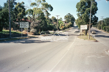
Negative - Photograph, Main Road, Eltham, c.Dec. 1983
Road sign advising of proposed reconstruction works of Main Road to install a roundabout at Mount Pleasant Road. Traffic to Lower Plenty and Templestowe to be diverted down Bridge Street (and Bolton Street) effective January 1984. The proposed roundabout did not proceed. Instead traffic islands on Mount Pleasant Road were installed in place of temporary blocked out islands.Film - Kodak CM 400 5079 7 strips, 26 framesinfrastructure, roads, road construction, roundabout, road sign, main road, mount pleasant road -
 Greensborough Historical Society
Article - Article, Journal, Melbourne Harbor Trust, "The Word is Progress": by Robin Hay, 1960_03
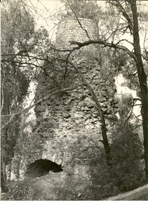
The opening of Reid's Lightweight Aggregate Pty Ltd ( a subsidiary of Reid's Quarries Ltd) in Greensborough, circa 1960. Explains the method of manufacture and uses of shalite in building industry. Reid's later became Albion Reid before being taken over by Boral. The shalite quarry, now closed, was on the site now called Blue Lake in Yellow Gum Park, Plenty.7 photocopied pages, text and colour and black nd white illustrations.reids quarries, shalite, aggregate, yellow gum park, plenty -
 Greensborough Historical Society
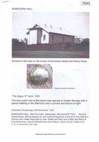
Article and Photograph, Bundoora Hall, 2019_
Compilation of transcriptions of newspaper articles and photographs from The Argus 06/04/1923; Advertiser (Hurstbridge) 23/11/1923 and 25/071924 and Diamond Valley News 21/07/1967. The first Bundoora District Hall on the corner of Grimshaw Street and Plenty Road Bundoora was opened in April 1923; its replacement on Noorang Avenue Bundoora in November 1967.4 p. black and white text and colour photographsbundoora district hall, bundoora hall, grimshaw street bundoora, plenty road bundoora -
 Greensborough Historical Society
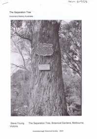
Article, The Separation tree, 2019_
The tree was one of two original red river gums that pre-dated European occupation, and was the site where colonists congregated to celebrate the announcement of Victoria's separation from New South Wales on 15 November 1850. It died as the result of vandalism in 2010 and 2013. Saplings of the original are planted around Melbourne, including along the Plenty River Trail in Greensborough3 p. Wikipedia article; photograph of the tree in the Botanical Gardens, Melbourne (before it was vandalised), and copy of the document of separation of the province of Victoria from the Colony of New South Wales, owned by Colin Boucher..separation tree -
 Greensborough Historical Society
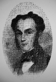
Photograph - Digital image, Portrait of Edward Green, 1850c
Portrait of Edward Green. In the 1840s, Edward B. Green ran the mail service between Melbourne and Sydney and owned a parcel of land on the Plenty River. He engaged a surveyor to draw up plans and lay out a township on the slopes overlooking the river, and to mark out small farm holdings on the flats. This small township named after him is now Greensborough.Digital copy of portrait.edward bernard green, greensborough history -
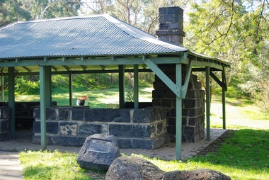
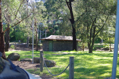
 Greensborough Historical Society
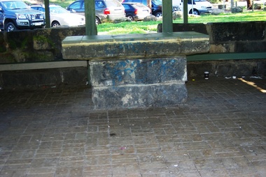
Photograph - Digital Image, Pioneer Reserve 2014 -2, 01/10/2014
Pioneer Reserve, Greensborough is a small park on the corner of St Helena and Diamond Creek Roads. It is adjacent to the site of Greensborough's first bridge across the Plenty River, c. 1864 - 1960s. The shelter, viewing platform, retaining wall and entrance are built from the bridge's massive bluestone arched abutments dismantled between 1974 and 1983. Photograph by Marilyn Smith 2014.Digital copy of colour photograph.pioneer reserve greensborough -
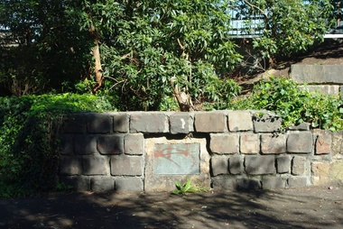
 Greensborough Historical Society
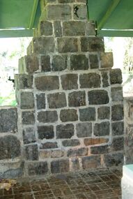
Photograph - Digital Image, Pioneer Reserve 2014 -3, 01/10/2014
Pioneer Reserve, Greensborough is a small park on the corner of St Helena and Diamond Creek Roads. It is adjacent to the site of Greensborough's first bridge across the Plenty River, c. 1864 - 1960s. The shelter, viewing platform, retaining wall and entrance are built from the bridge's massive bluestone arched abutments dismantled between 1974 and 1983. Photograph by Marilyn Smith 2014.Digital copy of colour photograph.pioneer reserve greensborough -
 Greensborough Historical Society
Photograph - Digital Image, Pioneer Reserve 2014 -4, 23/09/2014
Pioneer Reserve, Greensborough is a small park on the corner of St Helena and Diamond Creek Roads. It is adjacent to the site of Greensborough's first bridge across the Plenty River, c. 1864 - 1960s. The shelter, viewing platform, retaining wall and entrance are built from the bridge's massive bluestone arched abutments dismantled between 1974 and 1983. Photograph by Marilyn Smith 2014.Digital copy of colour photograph.pioneer reserve greensborough -
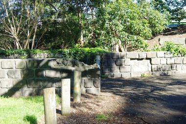
 Greensborough Historical Society
Photograph - Digital Image, Pioneer Reserve 2014 -5, 23/09/2014
Pioneer Reserve, Greensborough is a small park on the corner of St Helena and Diamond Creek Roads. It is adjacent to the site of Greensborough's first bridge across the Plenty River, c. 1864 - 1960s. The shelter, viewing platform, retaining wall and entrance are built from the bridge's massive bluestone arched abutments dismantled between 1974 and 1983. Photograph by Marilyn Smith 2014.Digital copy of colour photograph.pioneer reserve greensborough -
 Greensborough Historical Society
Photograph - Digital Image, Pioneer Reserve 2014 -6, 23/09/2014
Pioneer Reserve, Greensborough is a small park on the corner of St Helena and Diamond Creek Roads. It is adjacent to the site of Greensborough's first bridge across the Plenty River, c. 1864 - 1960s. The shelter, viewing platform, retaining wall and entrance are built from the bridge's massive bluestone arched abutments dismantled between 1974 and 1983. Photograph by Marilyn Smith 2014.Digital copy of colour photograph.pioneer reserve greensborough -
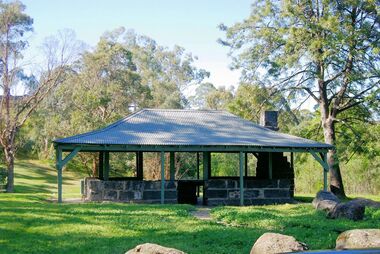 Greensborough Historical Society
Photograph - Digital Image, Pioneer Reserve 2014, 23/09/2014
Pioneer Reserve, Greensborough is a small park on the corner of St Helena and Diamond Creek Roads. It is adjacent to the site of Greensborough's first bridge across the Plenty River, c. 1864 - 1960s. The shelter, viewing platform, retaining wall and entrance are built from the bridge's massive bluestone arched abutments dismantled between 1974 and 1983. Photograph by Marilyn Smith 2014.Digital copy of colour photograph.pioneer reserve greensborough -
 Greensborough Historical Society
Photograph - Digital Image, Pioneer Reserve 2014 -8, 23/09/2014
Pioneer Reserve, Greensborough is a small park on the corner of St Helena and Diamond Creek Roads. It is adjacent to the site of Greensborough's first bridge across the Plenty River, c. 1864 - 1960s. The shelter, viewing platform, retaining wall and entrance are built from the bridge's massive bluestone arched abutments dismantled between 1974 and 1983. Photograph by Marilyn Smith 2014.Digital copy of colour photograph.pioneer reserve greensborough -
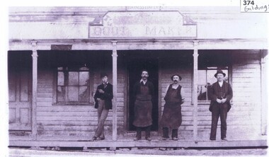 Greensborough Historical Society
Photograph, Gildings bootmaker, 1888c
Photograph of four men standing on the porch of Gildings Bootmaker's shop in Main Street Greensborough. John Gilding is standing in front of doorway. Harness maker W. Woodward stands next to him. The shop was opposite the Greensborough Fire Station in Church and in 1885 his shop and home were moved to the lower end of Main Street near the Plenty River.Links: 00374:01277:01278:01279:01280 Copy of black and white photographjohn gilding, gilding family -
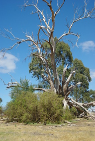 Greensborough Historical Society
Photograph - Digital image, Marilyn Smith et al, Janefield Precinct: dead gum tree and box thorns, 27/11/2014
Janefield Precinct: dead gum tree and box thorns. The remains of this site are between Greensborough and Janefield. A RAAF Hygiene Training Camp was located on the Plenty River, just south of the Janefield community. It was in use from 1944 to 1946. The Camp was constructed from salvaged materials. Instruction included building and maintenance of grease traps, latrines, elementary plumbing and carpentry.Early remains of a WW2 training campDigital colour photograph.janefield, raaf hygiene training camp janefield -
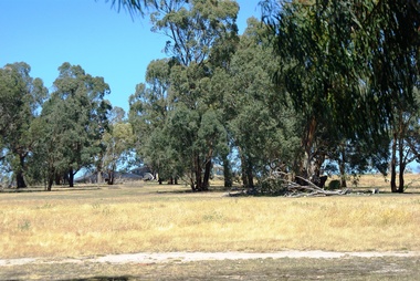 Greensborough Historical Society
Photograph - Digital image, Marilyn Smith et al, Janefield Precinct: Looking towards the future - new residential development, 27/11/2014
Janefield Precinct: Looking towards the future - new residential development. The remains of this site are between Greensborough and Janefield. A RAAF Hygiene Training Camp was located on the Plenty River, just south of the Janefield community. It was in use from 1944 to 1946. The Camp was constructed from salvaged materials. Instruction included building and maintenance of grease traps, latrines, elementary plumbing and carpentry.Early remains of a WW2 training camp Digital colour photograph.janefield -
 Greensborough Historical Society
Photograph - Digital image, Marilyn Smith et al, Janefield Precinct: Looking toward grave area from camp, 27/11/2014
Janefield Precinct: Looking toward grave area from camp. The remains of this site are between Greensborough and Janefield. A RAAF Hygiene Training Camp was located on the Plenty River, just south of the Janefield community. It was in use from 1944 to 1946. The Camp was constructed from salvaged materials. Instruction included building and maintenance of grease traps, latrines, elementary plumbing and carpentry.Early remains of a WW2 training camp Digital colour photograph.