Showing 10989 items matching " land"
-
 Greensborough Historical Society
Tie, Watsonia High School Uniform - Tie, 1985c
Watsonia High School tie. The Watsonia High School and Watsonia Technical School were merged to form Greensborough Secondary College for the beginning of the 1990 school year, with the high school campus serving as a senior school for years 11 and 12, and the larger technical school used as a junior campus. It was renamed Greensborough College when the former high school campus was closed in 1992. This land was redeveloped into housing lots.This tie is part of a small collection of Watsonia High School memorabilia.Red with ble and white stripe, school tie made from wool.Australian Pure New Wool Logowatsonia high school, school uniform, austico, ties -
 Greensborough Historical Society
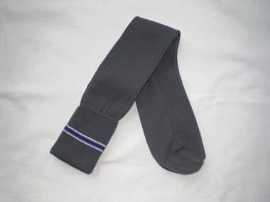
Socks, Watsonia High School Uniform - Socks WaHIGH, 1985c
Watsonia High School socks. The Watsonia High School and Watsonia Technical School were merged to form Greensborough Secondary College for the beginning of the 1990 school year, with the high school campus serving as a senior school for years 11 and 12, and the larger technical school used as a junior campus. It was renamed Greensborough College when the former high school campus was closed in 1992. This land was redeveloped into housing lots.This pair of socks is part of a small collection of Watsonia High School memorabilia.Winter uniform long socks. Grey with stripe around top.This pair is brand new - never worn.watsonia high school, school uniform, brandella, socks -
 Warrnambool and District Historical Society Inc.
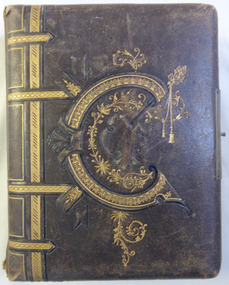
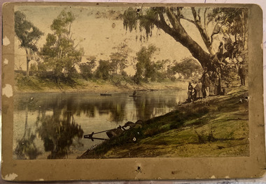
Album - Portrait photos Frisch, Circa 1888
A collection of photographs depicting numerous people. Some have been taken by studios such as Lovewell & Co, Hider, Jordan and Daniel Clarke of Warrnambool. Most of the photos are unnamed but of those that are there is a Thom Wickham, E. M. Fleming, Henry and Stanly Frisch. There are also a number of photographs depicting land clearing and wood cutting also a couple of cards, one happy New year and Glaedelig Jul( Danish Merry Christmas)An album typical of the era with local family connections as well as work by local photographersBrown leather cover with gold figure work over embossing on the front with possibly the letter,”C”. The back cover is entirely embossed. Edges of metal clasp are on front and back cover but clasp part is missing. Gold edges to pages, which are all heavy card. Front inside page has pink briar roses with “Album” on card inserted through it.Jan 17th 1888. To Morris from H Bambrick?warrnambool, warrnambool photographers, lovewell & co, jordan photographers, daniel clarke, thom wickham, e m fleming, henry frisch, stanley frisch -
 Orbost & District Historical Society
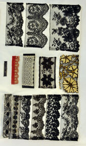
lace, 1800-1900
These laces belonged to Mrs.J. Pardew. Edward James Pardew died in 26/9/1927 aged 92. He came to Orbost from New Zealand in 1886 and selected 720 acres of hill land in the Brodribb area. He was a member of the first Orbost Shire Council. His daughter had a fruit & meat shop in McLeod Street. He was an inaugural vestryman of St James Church of England.Lace is an ornamental openwork fabric created by looping, twisting, braiding or knotting threads either by hand or by machine.This item is aesthetically significant and has a connection to an early Orbost settler.Twelve pieces of assorted laces on card - 3 cards.lace haberdashery cotsume accessories pardew-edward -
 Orbost & District Historical Society
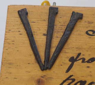
nails on board, 1885
These nails were made for Walter John Mundy (1868-1944). Often imported nails made for the softer English and North American timbers bent when hammered against the harder colonial woods and so The Mundy family were farmers / settlers in the Snowy River area since c. 1880s. The original Mundy family moved to a land "selection" at Betebolong in the early 1880's from Buchan. It's only over the past century or so that the mass-produced nail has become an inexpensive and common way to join materials. These three iron nails were hand made by an early Orbost settler or blacksmith in the 1880's, using iron, forge and anvil. They are examples of the types of nails used in the 19th century. A rectangular, wooden(athel pine?) board with three hand-made nails glued in fan design to top left corner of section of floorboard. There is a short length of yellow cord attached for hanging. To the right of the nails is hand-written text in black. the nails have irregular shanks and hammer marks on both shanks and heads.right of nails - " Flooring & nails from Walter Mundy's house at Jarrahmond built C.1885. Still in use to this day."mundy-walter hand-made-nails -
 Uniting Church Archives - Synod of Victoria
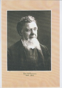
Photograph, Undated c.1864
Alexander Morison was ordained in Hobart, Tasmania 19/02/1839. Ministry: CMS missionary in Van Dieman's Land 1838 - 1839; Independent Church Collins St. Melbourne 1843 - 1864; Presbyterian supply ministry 1865 - 1869; Presbyterian Church Clunes 1869 - 1872; Honorary Librarian/Professor of Hebrew and Church History, Congregational College Victoria 1880 - 1887. Died 14/04/1887.Photocopy of original B & W head and shoulders portrait of the Rev Alexander Morison.Rev A. Morison 1843 - 1864 -
 Hume City Civic Collection
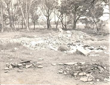
Photograph, late 1960s
In the late 1960s St. Mary's Anglican Church was dismantled from its Oaklands Road site and rebuilt on land in Bulla township adjacent to the old shire offices. It was moved because of the interference it would create for aircraft landing in the new Melbourne Airport at Tullamarine. The site has been left timbered because some of the district's early settlers were buried in the church yard before the Bulla Cemetery was established.A black and white photograph of the site of the former St. Mary's Anglican Church at Oaklands Road. There are heaps of building rubble in the foreground and trees in the background.st. mary's anglican church - bulla, oaklands road, graveyards, george evans collection -
 Unions Ballarat
Ledger. Political Labor Council of Victoria, Ballarat Branch, March 1911-August 1912
The ledger is part of the financial recordkeeping of the Political Labor Council of Victoria, Ballarat Branch. Constitution of the Political Labor Council of Victoria can be found at http://tinyurl.com/politicallabourcouncilvic. It had platforms at federal, state and municipal levels. The state platform includes land policy, financial policy including restriction of public borrowing, reform of parliamentary structure, industrial regulation, free education, support for technical education and adequate pensions.Constitutes part of the history of the Political Labor Council of Victoria. Financial transactions. Paper ledger - one volume.political labor council of victoria - ballarat branch, btlc, ballarat regional trades and labour council, finance - record keeping -
 Whitehorse Historical Society Inc.
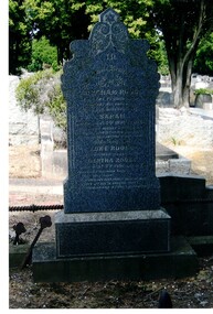
Photograph, Tombstone - Rooks family
The Rooks family emigrated from England in 1857. Abraham Rooks came to Forest Hill in 1862 and leased 79 acres. After 10 years of successful farming he owned the land. Abraham Rooks held the first church meetings in his home and in 1865 was one of the trustees to receive a crown grant to erect a chapel. In 1970 a school was attached to the chapel. Rooks Road is named after him.Coloured photo of the Rooks family tombstone - grave 226, Methodist section|Rooks, Abraham died 1 September 1889, aged 65 years|Rooks, Sarah died 2 January 1898, aged 66 yearsrooks, abraham, rooks, sarah, tombstones, rooks road, vermont -
 Hume City Civic Collection
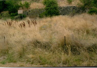
Photograph, The Terraces, 1980s
The stone wall is part of the terraces that were built into the hillside at the winery at Goonawarra. They were constructed in the early days when the vineyard was established to terrace the hillside for growing vines. The winery was originally established by Joh Goodall Francis, a former member of the Victorian Legislative Assembly. He acquired a parcel of crown land and proceeded to develop it as a vineyard. The terraces were built by vignerons, who were employed to work on the property. Goonawarra Winery was one of a number of vineyards that were established in the Sunbury area in the 1800s. The volcanic soil and temperate climate were ideal for grape growing.A coloured photograph of a stone wall with a notice to the left of the wall and long dried grassland in the front. A barbed wire fence is in the foreground.terraces, vineyards, goonawarra, james goodall francis -
 Kew Historical Society Inc
Photograph - Wurundjeri People at Studley Park
The Wurundjeri Woi Wurrung People were the original owners of the land on which the City of Boroondara is now located. They made active use of the Yarra for food and transport [an original canoe is held in the collection of the Melbourne Museum]. From 1863, members of the Wurundjeri Woi Wurrung were resettled at the Corranderrk Aboriginal reserve at Healesville. The [now] best known member of the Wurundjeri People was William Barak, who may be pictured here.If the attribution in the annotation is correct, then this may be the earliest photograph of members of the Wurundjeri People at Kew. The photo may be unique.Hand tinted photograph on mounting card of members of the Wurundjeri Woi Wurrung on the banks of the River Yarra, allegedly at Studley Park before 1855 [according to the annotation on the reverse] The photograph of the river and its near and far banks includes two boats on the river, a row boat and a canoe, and people standing on the near bank or seated on the branch of a tree. In addition to men and women of the Wurundjeri People, there appears to be two Europeans pictured, one wearing a hat and the other standing at right. Annotations on the reverse identify a [possible] location and date. [Size: Mount 140 x 215mm | Photograph 125 x 190mm]Various hands and dates: "Original lead pencil lettering Studley Yarra Yarra / Yarra Yarra Studley / Studley (Park?) / Note aboriginals in a bark canoe / Prior 1855 / Very early photo Yarra River originally known as the Yarra Yarra / [illegible part word in ink]".wurundjeri woi wurrung, yarra river, aboriginal and torres straight islander -
 Vision Australia
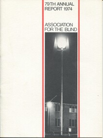
Administrative record - Text, 79th Annual report 1974 Association for the Blind of Victoria, 1981
Articles in annual report include: President's report, finance report, auditor's report, balance sheet, nursing homes, social work, rehabilitation, low vision clinic, honorary services, auxiliary income, blind members, sport and recreation, life governors. There are reports on launch of the Guiding Light Appeal, purchase of land near Elanora, Kelaston extensions and a property secured at Geelong as well as the awarding of Elsie Henderson's MBE.1 printed volume with illustrationsassociation for the blind, corporation records, henry bolte, rohan delacombe, john taylor, arthur wilkins, bruce small, hubert opperman, john wicking -
 The Beechworth Burke Museum Research Collection
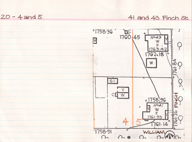
Card (Series) - Index Card, George Tibbits, 41 and 43 Finch Street, Beechworth, 1976
George Tibbits, University of Melbourne. Faculty of Architecture, Building and Town & Regional PlanningIndex system that support the research for Beechworth : historical reconstruction / [by] George Tibbits ... [et al]Arranged by street names of BeechworthEach index card includes: street name and number of property, image of property, allotment and section number, property owners and dates of ownership, description of the property according to rate records, property floor plan with dimensions.beechworth, george tibbitsbeechworth, george tibbits -
 The Beechworth Burke Museum Research Collection
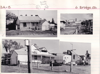
Card (Series) - Index Card, George Tibbits, 6 Bridge Street, Beechworth, 1976
George Tibbits, University of Melbourne. Faculty of Architecture, Building and Town & Regional PlanningIndex system that support the research for Beechworth : historical reconstruction / [by] George Tibbits ... [et al]Arranged by street names of BeechworthEach index card includes: street name and number of property, image of property, allotment and section number, property owners and dates of ownership, description of the property according to rate records, property floor plan with dimensions.beechworth, george tibbitsbeechworth, george tibbits -
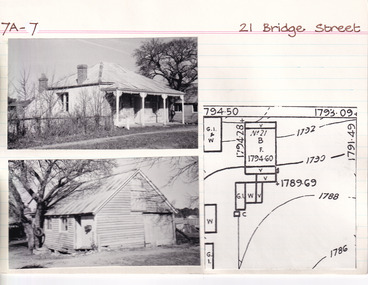 The Beechworth Burke Museum Research Collection
Card (Series) - Index Card, George Tibbits, 21 Bridge Street, Beechworth, 1976
George Tibbits, University of Melbourne. Faculty of Architecture, Building and Town & Regional PlanningIndex system that support the research for Beechworth : historical reconstruction / [by] George Tibbits ... [et al]Arranged by street names of BeechworthEach index card includes: street name and number of property, image of property, allotment and section number, property owners and dates of ownership, description of the property according to rate records, property floor plan with dimensions.beechworth, george tibbitsbeechworth, george tibbits -
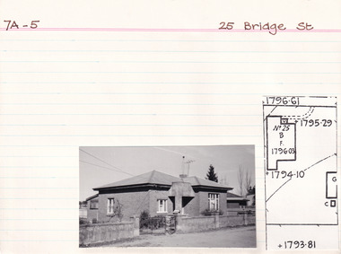 The Beechworth Burke Museum Research Collection
Card (Series) - Index Card, George Tibbits, 25 Bridge Road, Beechworth, 1976
George Tibbits, University of Melbourne. Faculty of Architecture, Building and Town & Regional PlanningIndex system that support the research for Beechworth : historical reconstruction / [by] George Tibbits ... [et al]Arranged by street names of BeechworthEach index card includes: street name and number of property, image of property, allotment and section number, property owners and dates of ownership, description of the property according to rate records, property floor plan with dimensions.beechworth, george tibbitsbeechworth, george tibbits -
 Linton and District Historical Society Inc
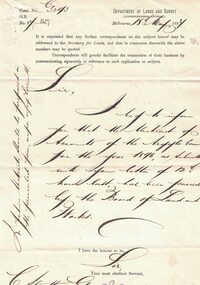
Letter, Paper manufactured by T. Edmonds 1890 (watermark), Department of Lands and Survey, Argyle Common, Linton, 1897, 18.05.1897
Letter written on behalf of Tho. MacGibbon, Secretary for Lands, to C. Stratton, Secretary, Argyle Common, Linton. Acknowledging receipt of Argyle Common accounts for 1896, and informing of their passing by the Board of Land and Parks. Also requesting that in future the accounts should be prepared on the prescribed form, a copy of which was enclosed. Found in the home of Miss Margaret Gorman after her death. See form sent with letter - Registration No. 1617Handwritten letter on grey paper headed Department of Lands and Survey, dated 18th May 1897. Addressee C. Stratton Esq.-Secretary-Argyle Common-Linton.argyle common linton, animal grazing, agricultural activity -
![Map, Plan showing proposed deviation of the road through McKenzie's Flat to Bacchus Marsh. [Undated]](/media/collectors/5e461d8021ea67224c82f2a1/items/677d22f37f2053f3e5d500dc/item-media/677d25247f2053f3e5d50950/item-fit-380x285.jpg) Bacchus Marsh & District Historical Society
Bacchus Marsh & District Historical SocietyMap, Plan showing proposed deviation of the road through McKenzie's Flat to Bacchus Marsh. [Undated]
The date of this map or plan is uncertain. McKenzie's Flat is a bushland picnic area on the Lerderderg River in the Lerderderg State Park close to Bacchus Marsh. The proposed road deviation shown on this map is very close to a sharp bend in the Lerderderg River which shows an island in the centre of that bend. The name of a landholder, J.B. Perry is shown on the map close to the area of the road deviation.The land shown is identified as within the Parish of Merrimu.Single page map showing a proposed deviation of the road from McKenzie's Flat to Bacchus Marsh. Scale: 5 chains to 1 inch. Part of a set of maps which are pasted into a bound volume containing 76 maps or plans in total. High resolution digital image stored on BMDHS computer network. mckenzies flat bacchus marsh, bacchus marsh roads and streets -
 Sunbury Family History and Heritage Society Inc.
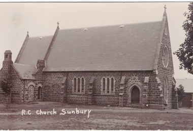
Postcard, R.C. Church Sunbury
On 17th January 1856, two acres of land was granted for the building of a school and church on that site in Macedon Street. A small temporary building was erected on the site and on 13th December 1864 the foundation stone was laid for the new stone church which was known as 'Our Lady of Mount Carmel'. At times it was also known as St. Mary's Church, which was confusing because the Anglican Church is named St. Mary's Church.It is one of the oldest churches to be established in Sunbury.A non-Digital post card photograph of the Roman Catholic Church in Sunburyour lady of mount carmel catholic church, macedon street, sunbury -
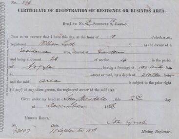 Linton and District Historical Society Inc
Certificate, John Ferres, Government Printer, Melbourne, Certificate of Registration of Residence or Business, William Todd, Linton, 1886, 1886
This certificate was issued to register William Todd as the owner of a residence area at Allotment 28, Section 4, Linton. This land was held under Miner's Right No. 93197. The certificate was issued at Smythesdale on December 2nd by John Lynch, Mining Registrar. Miner's Right No. 93917, 18 September 1886. The Todd family's first home is believed to have been at this site in Grantley Street. See photograph - Registration no. 465.Small blue-grey sheet of paper, black printed, handwritten detail.william todd -
 Melbourne Tram Museum
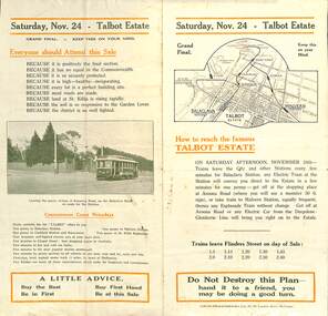
Ephemera - Real estate sale, Forrester & Co, "Talbot Estate" Balaclava, Nov. 1917
Pamphlet advertising the sale of land at the Talbot Estate on the south side of Balaclava Road, Balaclava on Saturday 24 Nov. 1917. Promotes the train service from Flinders St, tram service, St Kilda Esplanade, tram services including a photo of PMTT No. 61 at the intersection of Kooyong Road and Balaclava Road. Gives details of the tram fares, agents, solicitors, terms of sale, roads and water supplies.Demonstrates the style of land sale pamphlet including the availability of tram services to prospective purchasers.Pamphlet - folded - printed in two colours of cream coloured paper with photographs.sale of land, trams, balaclava, balaclava road, real estate, talbot estate -
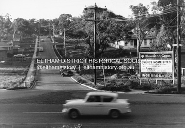 Eltham District Historical Society Inc
Photograph, R.J. Manuell, Woodland Crest, Briar Hill, c.1964
View of Squires land which was subdivided for housing - two parts Woodland Crest higher part off Woodland Grove and Calrossi Avenue, Briar Hill showing new roads with curb and channelling and footpaths. No date. Looking up Hyacinth Avenue, Briar Hill from Sherbourne Road. Hibiscus Avenue first on right then Acacia Court. The white house on Hibiscus Avenue still exists (No. 3)Black and white photograph printed with white bordersVerso: COO2briar hill, real estate, woodland grove, squires, roads, acacia court, hibiscus avenuse, hyacinth avenue, woodland crest estate, inge bros pty ltd -
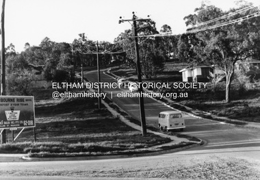 Eltham District Historical Society Inc
Photograph, R.J. Manuell, Sherbourne Rise, Briar Hill, c.1964
Sherbourne Rise Estate, looking up Woodland Grove from Calrossie Avenue, Briar Hill. The house is believed to be No. 8. This is prior to Regal Court being established off Woodland Grove. View of Squires land which was subdivided for housing - two parts Woodland Crest higher part off Woodland Grove and Calrossi Avenue, Briar Hill showing new roads with curb and channelling and footpaths. No date.Black and white photograph printed with white bordersVerso: COO2briar hill, real estate, woodland grove, squires, roads, sherbourne rise estate -
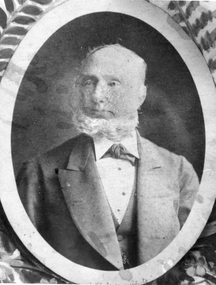 Stawell Historical Society Inc
Photograph, Mr George Jennings -- Studio Portrait
Portrait of George Jennings "Mayo Park" Lubeck. George Jennings was elected to Old Roads Board in 1863. Except for the years 1882 - 84. He served on the Council until 1891 - 1874 Shire President. From County Galway in Ireland. Jennings arrived in Pleasant Creek in 1858. For many years he owned "The Western Turf Hotel at Quartz Reefs. Selected land on the Ashens Run - settled there in 1870.Black and white photograph of a male in a oval setting with decoration in corners making a rectangle. Photograph in brown folder. The male is dressed in a suit, tie at neck of shirt, short hair and with a beard. Also an enlargement of studio photograph.George Jennings Mayo Park Lubeck written in biro.lubeck stawell shire president -
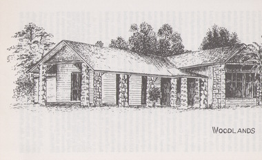 Sunbury Family History and Heritage Society Inc.
Artwork, other, Ian Symonds, Woodlands Homestead
The sketch of Woodlands Homestead is a reproduction of Ian Symonds original drawing. He was a Sunbury resident and was an active member in the local art group and gallery. He drew many black and white drawings of interesting homesteads and sites in thew district. William Pomeroy Greene, from Scotland settled on land near Gellibrand Hill and Moonee Ponds Creek at Bulla and built his prefabricated homestead own the site.The Greene family were one of the early European settlers to settle in Bulla. A photograph of a black and white sketch of a homestead.WOODLANDSwoodlands homestead, gellibrand hill, william pomeroy greene, bulla, moonee ponds creek -
 Kiewa Valley Historical Society
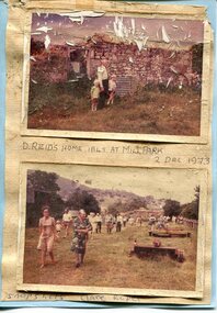
Photographs x 2- D Reids home at Mill Park 1973, 2/12/1973
David Reid (1820-1906) was a pastoralists and politician. He left school at 16 and after meeting the overlander John Gardiner he decided to look for land south of the Murray River. Equipped by his father with some 500 head of cattle, 2 bullock wagons and teams and 6 assigned servants, he reached the Ovens River on 8 September 1838. David settled at Currargarmonge, near Wangaratta. At the end of 1843 he took up land near Yackandandah. In 1847 he took up a section of the family run of which Woorajay (Wooragee) formed a part. He built the first water driven flour-mill in the district on his Yackandandah run in 1845; his woolclip of 1848 was one of the first to be handled by R. Goldsbrough and was claimed to come from sheep descended from stock imported in the 1820s from George III's flock. Going into politics, he held the Legislative Assembly seat of Murray from October 1859 to May 1862. David Reid was a highly regarded grazier and local politician who was significantly involved in settlement around the Yackandandah area. Photo demonstrates ongoing interest in the local history of the area and its early residents2 colour photographs mounted together on buff card 1. Man and 2 children (unidentified) standing outside the remains of the Reid home. 2 Dec, 1973 2. Group of unidentified people on a tour of the old homestead of D. Reid. 2 Dec, 19731. Handwritten in black ink under photo 'D. Reid's home 1845. At Mill Park. 2 Dec 1973 2. Handwritten in blue ink under photo 'Snapshots Clare Roper"clare roper -
Glen Eira Historical Society
Document - Cantala
Various documents and correspondence detailing the history of the house and land on the corner of Dandenong and Waiora Roads, Caulfield, known as Cantala before being demolished and the land subdivided. The first document is a typed 3 page history from Caulfield Historical Society dated 02/1974, describing the owner of the property, Septimus Miller, as well as architectural features of the house Cantala. The second document is one page of typed correspondence from T J Hart to the editor of Southern Cross, dated 01/11/1973, describing the architectural features and history of Cantala. The file also includes a copy of a typed letter from Brighton Historical Society concerning research conducted about Cantala and the subdivision and detailing the owners and occupiers of flats erected where Cantala stood. Accompanying this document is a one page handwritten note providing the same details. Finally, the file includes a one page photocopy, undated, of an entry in Who’s Who in the World of Women of Mrs Septimus Miller (Muriel), the second wife and widow of Septimus Miller.miller septimus, miller henry money, mattinson elizabeth, bell clara johnstone, stewart gwendoline, henderson helen muriel, miller ronald nevil damian, salway william, hart t j, miller helen, pirera m t, fetter a, bullock hilary, landells rosalind, redleap, cantala, caulfield, caulfiled north, dandenong road, wiora, waiora road, alma road, brighton cemetery, caulfield racecourse, findon avenue, cantala avenue, olgita, rivoli, caulfield historical society, victoria racing club, horse racing, italianate style, art deco, architectural styles, architectural features, balconies, towers, stairs, bay windows, mansions, stables, land subdivisions, monuments and memorials, gothic (revival) architecture, drawing rooms, walking trails, parks and reserves, gardens, flats -
 Victoria Police Museum
Police Stations (Apsley)
Apsley is a small town in Victoria, Australia. It is on the Wimmera Highway, in the Shire of West Wimmera, 420 kilometres north-west of Melbourne, and 7 kilometres east of the South Australian border. Apsley Police Station opened on 29th November 1884 and was originally located in Wallace Street. It was staffed by one Foot Constable (motor cycle). The building was described, in 1930, as a four-roomed dwelling with an iron roof, set on a quarter of an acre of land. There was a bathroom, a WC, wash-house and a garage. An office adjoined the house and there was also a lockup. The station moved several times until the mid 1960s when a timber residence was moved onto land adjacent to the Post Office. The building is believed to have been transported from the Stawell area. Apsley is one of a handful of one-man police stations in Victoria and its current location, including residence, is at 19 Splatt Street. Apsley was in the Western District when it opened, then in "L" (Wimmera) District from January 1948 and "M" (Highlands/Wimmera) District from March 1990. 4 black & white photos, 1965 3 colour photos, 1987police stations; apsley police station -
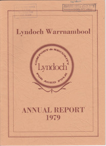 Warrnambool and District Historical Society Inc.
Document - Lyndoch Warrnambool 1979 Annual Report, 1979
This is the 1979 Annual Report for Lyndoch Home and Hospital for the Aged, Warrnambool. It contains lists of Board Members, a President’s Report, a sketch of a proposed new building, financial reports, photographs and a list of Life Governors. Lyndoch Home for the Aged was established in 1952 and has developed with a wide range of facilities for the aged since that date. The original Lyndoch property near the mouth of the river Hopkins was owned by a Melbourne tea merchant, George Rolfe, who bought the land when there were only on the site a couple of cottages and a larger building which had been a school, Warrnambool Grammar, run by Henry Kemmis. Rolfe acquired the land in the 1870s and named the property Lyndoch after the town in the Barossa Valley where he had lived. He owned Lyndoch for 44 years and it was his stepdaughter, Florence Lake who built in the 1920s the bungalow known as Lyndoch which forms the original building of the Lyndoch Home for the Aged. Today the facility is called Lyndoch Living.This report is kept for the benefit of researchers wanting details of the history of Lyndoch over the past thirty or forty years.This is a booklet with a cardboard buff-coloured cover. There are six double-sided pages with printed material on white paper with a yellow and orange stripe across the top of the pages.On front cover: Lyndoch Warrnambool, Annual Report 1979 In brown circle on front cover: Lyndoch, Comfort and Security for Aged Folk Two library stamps on front cover (Warrnambool Library) lyndoch, aged care facility, warrnambool, hopkins, warrnambool grammar -
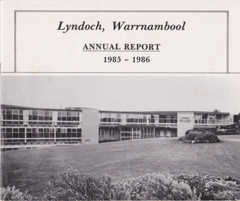 Warrnambool and District Historical Society Inc.
Document - Lyndoch Warrnambool Annual Report 1985-86, 1986
This is the 1985-6 Annual Report for Lyndoch Home and Hospital for the Aged, Warrnambool. It contains lists of Board Members, a President’s Report, photographs, Lyndoch’s Aims, financial reports and a list of Life Governors. Lyndoch Home for the Aged was established in 1952 and has developed with a wide range of facilities for the aged since that date. The original Lyndoch property near the mouth of the River Hopkins was owned by a Melbourne tea merchant, George Rolfe, who bought the land when there were on the site only a couple of cottages and a larger building which had been a school, Warrnambool Grammar, run by Henry Kemmis. Rolfe acquired the land in the 1870s and named the property Lyndoch after the town in the Barossa Valley where he had lived. He owned Lyndoch for 44 years ad it was his stepdaughter Florence Lake who built in the 1920s the bungalow known as Lyndoch which forms the original building of Lyndoch Home for the Aged. Today the facility is called Lyndoch Living. This 1985-6 report is kept for the benefit of researchers wanting details of the history of Lyndoch over the past 30 or 40 years.This is a booklet with a plasticized white cover with a black and white photograph of a Lyndoch building on the front cover. There are eight double-sided pages with printed material and photographs. The pages are stapled.On front cover: ‘Lyndoch, Warrnambool, Annual Report, 1985-1986 On back cover: A black circle with the words: ‘Lyndoch, Comfort and Security for Aged Folk’. lyndoch aged care facility, warrnambool