Showing 9595 items
matching real estate
-
 Kew Historical Society Inc
Booklet - Yarraleen Estate, Bulleen, c.1966
... Subdivision plans and real estate flyers/brochures reveal... Subdivision plans and real estate flyers/brochures reveal a number ...Subdivision plans and real estate flyers/brochures reveal a number of aspects of urban development and history. The Kew Historical Society's collection of these plans, as well as advertisements extracted from magazines, cover key aspects of community development and architectural history of Kew and Kew Eat as well as surrounding suburbs. While most of the plans in the collection were gifted to the Society by the former City of Kew, a number of other plans and advertisements have been donated by individuals, of which this is an example.Original 8-page booklet advertising a new residential development in Bulleen entitled 'Yarraleen'. The glossy multi-colour brochure includes historic and contemporary photographs of the Yarra Valley, graphic designs of potential residential development, photographs of key facilities (Marcellin College, Golf links, local swimming holes, the Beaver Swim School, Carey Grammar School Oval and grandstand, shopping strips, and farmland).subdivisions -- bulleen (vic.), yarraleen estate -
Kew Historical Society Inc
Plan - 30 Choice Home Sites in Kilby Road, Meldrum Street and Fairway Drive, 1965
... Subdivision plans and real estate flyers/brochures reveal... Subdivision plans and real estate flyers/brochures reveal a number ...Subdivision plans and real estate flyers/brochures reveal a number of aspects of urban development and history. The Kew Historical Society's collection of these plans, as well as advertisements extracted from magazines, cover key aspects of community development and architectural history of Kew and Kew Eat as well as surrounding suburbs. While most of the plans in the collection were gifted to the Society by the former City of Kew, a number of other plans and advertisements have been donated by individuals, of which this is an example.Original 4-page, bifold brochure, one of two in the collection, of home sites created following the creation of the Eastern Freeway which separated a section of land owned by the Kew Golf Club from the main course. The new estate featured 30 lots in Meldrum Street, Kilby Road and Fairway Drive. subdivisions -- kew east (vic.), subdivisions -- kew (vic.), kew golf club -
Kew Historical Society Inc
Plan - 30 Choice Home Sites in Kilby Road, Meldrum Street and Fairway Drive, 1965
... Subdivision plans and real estate flyers/brochures reveal... Subdivision plans and real estate flyers/brochures reveal a number ...Subdivision plans and real estate flyers/brochures reveal a number of aspects of urban development and history. The Kew Historical Society's collection of these plans, as well as advertisements extracted from magazines, cover key aspects of community development and architectural history of Kew and Kew Eat as well as surrounding suburbs. While most of the plans in the collection were gifted to the Society by the former City of Kew, a number of other plans and advertisements have been donated by individuals, of which this is an example.Original 4-page, bifold brochure, one of two in the collection, of home sites created following the creation of the Eastern Freeway which separated a section of land owned by the Kew Golf Club from the main course. The new estate featured 30 lots in Meldrum Street, Kilby Road and Fairway Drive.subdivisions -- kew east (vic.), subdivisions -- kew (vic.), kew golf club -
Kew Historical Society Inc
Plan - Burke Road Junction Estate, East Kew, 1940
... Subdivision plans and real estate flyers/brochures reveal... Subdivision plans and real estate flyers/brochures reveal a number ...Subdivision plans and real estate flyers/brochures reveal a number of aspects of urban development and history. The Kew Historical Society's collection of these plans, as well as advertisements extracted from magazines, cover key aspects of community development and architectural history of Kew and Kew Eat as well as surrounding suburbs. While most of the plans in the collection were gifted to the Society by the former City of Kew, a number of other plans and advertisements have been donated by individuals, of which this is an example.Original 4-page bifold brochure advertising the Burke Road Junction Estate in Kew East. Advertised for sale in 1940, the estate comprised 16 'Central Allotments' fronting High Street, Kilby Road, and Glass Street. Pages 1 & 4, the front and back covers, includes a panoramic photograph of the junction which features a number of shops still extant, but also with buildings long demolished and redeveloped. These include the petrol station and the dairy on the southeast and southwest corners of Burke Road and High Street/Doncaster Road. The dairy includes a statue of a cow on its roof. Pages 2 & 3 include a detailed plan of the estate. subdivisions -- kew east (vic.), burke road junction estate -
 Kew Historical Society Inc
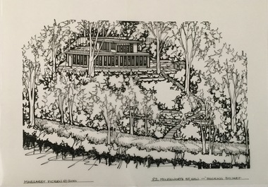
Drawing - Property Illustration, Margaret Picken, 82 Molesworth Street, Kew, 2001
... of a series created by Margaret Picken for a number of real estate... of a series created by Margaret Picken for a number of real estate ...After training as a Cartographic Draftsman within the mining industry, I worked as a property illustrator for real estate firms in the eastern suburbs of Melbourne for 22 years from 1983. I initially photographed houses with a Polaroid camera and made a 'thumbnail' sketch while there. The photos were used to scale off a sketch in pencil and then that sketch was overlaid with drafting film and the 'pen and ink' completed. The pens I used were the Rotring ‘Rapidigraph’ drafting pens. The ink was also made by Rotring (German).The film was ‘Rapidraw’, polyester drafting film, double matte. It takes a very fine line and doesn’t bleed. As well as house sketches, there were often floor plans and site plans ordered. Aerial sketches were ordered when the property needed an overall view. (Margaret Picken, 2020)The R Haughton James House (former) was built to a design by Robin Boyd in 1956-57. With its unusual plan form, this is one of Robin Boyd’s most important residential commissions of the period. The house was identified in heritage study as being of architectural significance at the state level. Alterations to the house were made in 1967, 1989, and 1999. This drawing is one of a series created by Margaret Picken for a number of real estate agents in Melbourne between 1983 and 2005. Each work is signed and dated by the artist.Gift of Margaret Picken, 2020Pen and ink architectural drawing on drafting film of 82 Molesworth Street, Kew by Margaret Picken.MARGARET PICKEN © 2001 / 82 MOLESWORTH ST, KEW ~ HOCKING STUARTartist -- margaret picken 1950-, architectural drawings -- houses -- kew (vic.), 82 molesworth street - kew (vic) -
 Melbourne Legacy
Document, Harelands
... have been compiled by a real estate agent as the header on each.... No. 01679. The report may have been compiled by a real estate agent ...Documentation dated January 1974 obtained by Legatee Trebilcock as a member of the Steering Committee (Residences) which had been formed to advise on the future of the Melbourne Legacy residences. See also Cat.No. 01676. The document describes the location and the buildings in detail and advises that Harelands appears to be in good condition but unsuitable for extension or alteration. See also Cat. No. 01679. The report may have been compiled by a real estate agent as the header on each page is 'Bernard Evans, Murphy Berg and Hocking Pty Ltd' Part of the history of Melbourne Legacy's involvement with residential care for children.Report on Harelands x 4 pages of photocopies of black type on white foolscap paper. residences, review, harelands -
 Warrnambool and District Historical Society Inc.
Administrative record - Rent Ledger, 1910 to 1925
... to a real estate firm or an accountancy or law firm dealing... to a real estate firm or an accountancy or law firm dealing ...The name of the business that produced the contents of this ledger is unknown. It is a record of rents paid by tenants to the property owners in Warrnambool and district from 1910 to 1925 and includes the rents paid and the dates. It probably belonged to a real estate firm or an accountancy or law firm dealing in property, mortgages and financial investments. Many of the names contained in the ledger are well-known (Coakley, Alston, Gleeson, McGennan etc) and the ones that are not so well known are mostly those with only one or two rental properties. This ledger is of some interest as a research tool giving information on property owners and renters in Warrnambool from 1910 to 1925. It will be of greater value if the name of the ledger owner can be found. This is a ledger with a cover made of wood and covered with a light brown material. It has a heavy metal insert inside to hold the pages. There are heavy card pages and white pages ruled with red and blue lines. The page entries are handwritten in ink. warrnambool renters 1910-1925, warrnambool property owners 1910-1925 -
 Bendigo Historical Society Inc.
Photograph - T C WATTS & SON COLLECTION: 25 WEBSTER STREET, BENDIGO, 1929
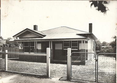
... and Susan Watts. Before the real estate business commenced, Thomas... and Susan Watts. Before the real estate business commenced, Thomas ...Thomas Crouch Watts was born on March 7th. 1865, to Joseph and Susan Watts. Before the real estate business commenced, Thomas and his brother were in partnership as booksellers and stationers in a shop at View Point. Thomas lived in a fine house in Rowan Street, which was called 'Ottawa' Thomas started his real estate business in the early 1900s in a shop in View Street. His daughter Edna was the book keeper and typist, Stewart Watson was the salesman and Stanley Phipps (Edith Lunn's father) was the property manager and valuer. When Thomas Watts died in 1914, his daughter took over the running of the business. She married Stewart Watson in 1918. Eventually the name of the business was changed to Bishop and Earl. From a letter from Edith Lunn re T.C. Watts & Son. 'The firm of T.C. Watts & Son later became Bishop and Earl. When the firm of Bishop and Earl ceased to operate after the death of Edith Lunn's father, S.P. Bishop, Miss. June Parry, Secretary of the BHS was a member of staff. June rescued all the photos of properties listed for sale from the office and placed them into the custody of the BHS.' Black and white original photograph mounted on grey cardboard. Weatherboard house, corrugated iron roof. Return verandah with wooden decoration. 1 chimney. 2 decorative gables above windows. Garden with lawn, shrubs and garden seat. Written on back of image 'H. Liddall, Webster Street. Terms £500 bal 61/2 %. £775 on 30.1.41 £250 deposit, low interest to be arranged. 25 Webster Street. White sticker attached to bottom of photo board ' December 1927 Pyke Street - Bendigo £1150' 2012 photo of house attached to record.Frank A. Jeffree Photo Bendigoplace, building, residential -
 Bendigo Historical Society Inc.
Photograph - T C WATTS & SON COLLECTION: LANGSTON STREET, BENDIGO, 1927
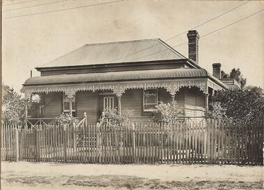
... and Susan Watts. Before the real estate business commenced, Thomas... and Susan Watts. Before the real estate business commenced, Thomas ...Thomas Crouch Watts was born on March 7th. 1865, to Joseph and Susan Watts. Before the real estate business commenced, Thomas and his brother were in partnership as booksellers and stationers in a shop at View Point. Thomas lived in a fine house in Rowan Street, which was called 'Ottawa' Thomas started his real estate business in the early 1900s in a shop in View Street. His daughter Edna was the book keeper and typist, Stewart Watson was the salesman and Stanley Phipps (Edith Lunn's father) was the property manager and valuer. When Thomas Watts died in 1914, his daughter took over the running of the business. She married Stewart Watson in 1918. Eventually the name of the business was changed to Bishop and Earl. From a letter from Edith Lunn re T.C. Watts & Son. 'The firm of T.C. Watts & Son later became Bishop and Earl. When the firm of Bishop and Earl ceased to operate after the death of Edith Lunn's father, S.P. Bishop, Miss. June Parry, Secretary of the BHS was a member of staff. June rescued all the photos of properties listed for sale from the office and placed them into the custody of the BHS.' Black and white photograph mounted on rectangular grey board. Weatherboard double fronted house, verandah with brick piers and timber supports, Two chimneys visible, small gable LH side front. C1920 . Woven wire fence. Single gate next to double gate. Written on back of image ' Marrows Langston St £700.Frank A Jeffree, Bendigoplace, building, residential, see also; previous reg. no mp11 (2000-16-01):and previous reg. no. mp13 (200-14-01) -
 Bendigo Historical Society Inc.
Photograph - T C WATTS & SON COLLECTION: HARNEY STREET, BENDIGO, 1930
... and Susan Watts. Before the real estate business commenced, Thomas... and Susan Watts. Before the real estate business commenced, Thomas ...Thomas Crouch Watts was born on March 7th. 1865, to Joseph and Susan Watts. Before the real estate business commenced, Thomas and his brother were in partnership as booksellers and stationers in a shop at View Point. Thomas lived in a fine house in Rowan Street, which was called 'Ottawa' Thomas started his real estate business in the early 1900s in a shop in View Street. His daughter Edna was the book keeper and typist, Stewart Watson was the salesman and Stanley Phipps (Edith Lunn's father) was the property manager and valuer. When Thomas Watts died in 1914, his daughter took over the running of the business. She married Stewart Watson in 1918. Eventually the name of the business was changed to Bishop and Earl. From a letter from Edith Lunn re T.C. Watts & Son. 'The firm of T.C. Watts & Son later became Bishop and Earl. When the firm of Bishop and Earl ceased to operate after the death of Edith Lunn's father, S.P. Bishop, Miss. June Parry, Secretary of the BHS was a member of staff. June rescued all the photos of properties listed for sale from the office and placed them into the custody of the BHS.' Black and white photograph mounted on rectangular brown board. House, weatherboard corrugated iron roof, bull nose verandah, picket fence, cast iron lace on verandah, 2 chimneys, central door, 1 window each side of door, wooden steps up to return verandah, Written on back of image 'Hunt, Harney Street, £575 Sewered' Faint stamp on back with date 11 April 1939. £250 deposit. Low interest to be arranged'Frank A. Jeffree, Bendigoplace, building, residential, previous register no. ''mp 10'' part of a collection of photographs used by estate agent t.c. watts and son -
 Bendigo Historical Society Inc.
Photograph - T C WATTS & SON COLLECTION: 29 PYKE STREET, BENDIGO, 1927
... and Susan Watts. Before the real estate business commenced, Thomas... and Susan Watts. Before the real estate business commenced, Thomas ...Thomas Crouch Watts was born on March 7th. 1865, to Joseph and Susan Watts. Before the real estate business commenced, Thomas and his brother were in partnership as booksellers and stationers in a shop at View Point. Thomas lived in a fine house in Rowan Street, which was called 'Ottawa' Thomas started his real estate business in the early 1900s in a shop in View Street. His daughter Edna was the book keeper and typist, Stewart Watson was the salesman and Stanley Phipps (Edith Lunn's father) was the property manager and valuer. When Thomas Watts died in 1914, his daughter took over the running of the business. She married Stewart Watson in 1918. Eventually the name of the business was changed to Bishop and Earl. From a letter from Edith Lunn re T.C. Watts & Son. 'The firm of T.C. Watts & Son later became Bishop and Earl. When the firm of Bishop and Earl ceased to operate after the death of Edith Lunn's father, S.P. Bishop, Miss. June Parry, Secretary of the BHS was a member of staff. June rescued all the photos of properties listed for sale from the office and placed them into the custody of the BHS.' Black and white original photograph mounted on grey board. House, weatherboard, corrugated iron roof, verandah, picket fence, wooden fretwork on gables and windows. Decoration along roof line, one chimney visible , garden with two palm trees. Bay window RH side. Harrison's Est £1150, 29 Pyke Street Bendigo written on back of image. Date: 9 Dec 1927. stamped on back.A. Jeffree, Bendgoplace, building, residential, previous reg. no. mp81 part of a collection of photographs used by estate agent t.c. watts and sons, bendigo to show potential purchasers. -
 Bendigo Historical Society Inc.
Photograph - T C WATTS & SON COLLECTION: 320 BARNARD STREET, BENDIGO, 1927
... and Susan Watts. Before the real estate business commenced, Thomas... and Susan Watts. Before the real estate business commenced, Thomas ...Thomas Crouch Watts was born on March 7th. 1865, to Joseph and Susan Watts. Before the real estate business commenced, Thomas and his brother were in partnership as booksellers and stationers in a shop at View Point. Thomas lived in a fine house in Rowan Street, which was called 'Ottawa' Thomas started his real estate business in the early 1900s in a shop in View Street. His daughter Edna was the book keeper and typist, Stewart Watson was the salesman and Stanley Phipps (Edith Lunn's father) was the property manager and valuer. When Thomas Watts died in 1914, his daughter took over the running of the business. She married Stewart Watson in 1918. Eventually the name of the business was changed to Bishop and Earl. From a letter from Edith Lunn re T.C. Watts & Son. 'The firm of T.C. Watts & Son later became Bishop and Earl. When the firm of Bishop and Earl ceased to operate after the death of Edith Lunn's father, S.P. Bishop, Miss. June Parry, Secretary of the BHS was a member of staff. June rescued all the photos of properties listed for sale from the office and placed them into the custody of the BHS.' Black and white original photographs (2) mounted on grey board house, weatherboard, bull nose veranda, picket fence, cast iron lace on verandah, three chimneys, central door, one window each side of door. Front of house, top section, painted white. Written on back of photo board (a) ' Mr. B. Murdoch, 320 Barnard Street Bendigo, £900 sewered' On back of (b) L. Simmonds, 239 Barnard St. £620' ( Address does not match with photo (a)) Date stamp 9 Dec 1927' 2012 photo of house attached to record. Faint printing in white in lower right corner ''Frank A. Jeffree Photo Bendigo'' Handprinted top R ''MP8''place, building, residential -
 Bendigo Historical Society Inc.
Photograph - T C WATTS & SON COLLECTION: PLUMRIDGE STREET, WHITE HILLS, Approx. 1900-35
... and Susan Watts. Before the real estate business commenced, Thomas... and Susan Watts. Before the real estate business commenced, Thomas ...Thomas Crouch Watts was born on March 7th. 1865, to Joseph and Susan Watts. Before the real estate business commenced, Thomas and his brother were in partnership as booksellers and stationers in a shop at View Point. Thomas lived in a fine house in Rowan Street, which was called 'Ottawa' Thomas started his real estate business in the early 1900s in a shop in View Street. His daughter Edna was the book keeper and typist, Stewart Watson was the salesman and Stanley Phipps (Edith Lunn's father) was the property manager and valuer. When Thomas Watts died in 1914, his daughter took over the running of the business. She married Stewart Watson in 1918. Eventually the name of the business was changed to Bishop and Earl. From a letter from Edith Lunn re T.C. Watts & Son. 'The firm of T.C. Watts & Son later became Bishop and Earl. When the firm of Bishop and Earl ceased to operate after the death of Edith Lunn's father, S.P. Bishop, Miss. June Parry, Secretary of the BHS was a member of staff. June rescued all the photos of properties listed for sale from the office and placed them into the custody of the BHS.' Black and white photograph mounted on rectangular grey board. House, weatherboard, corrugated iron roof. Bull nose veranda painted with stripes, picket fence, two wrought iron gates, one chimney, central door, one window each side of door. Three boards painted white, half way up front wall. Pergola on RH side of house. Tank stand LH side middle distance, name of house to left of door. 'Phillips, Plumridge Street, White Hills' written on back of photo board. 2012 photo of house attached to record.Frank A. Jeffree, Bendigoplace, building, residential -
 Bendigo Historical Society Inc.
Photograph - T C WATTS & SON COLLECTION: 'TIRRANNIE' GOLDEN SQUARE, 1929
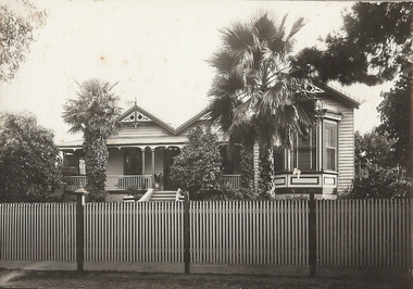
... and Susan Watts. Before the real estate business commenced, Thomas... and Susan Watts. Before the real estate business commenced, Thomas ...Thomas Crouch Watts was born on March 7th. 1865, to Joseph and Susan Watts. Before the real estate business commenced, Thomas and his brother were in partnership as booksellers and stationers in a shop at View Point. Thomas lived in a fine house in Rowan Street, which was called 'Ottawa' Thomas started his real estate business in the early 1900s in a shop in View Street. His daughter Edna was the book keeper and typist, Stewart Watson was the salesman and Stanley Phipps (Edith Lunn's father) was the property manager and valuer. When Thomas Watts died in 1914, his daughter took over the running of the business. She married Stewart Watson in 1918. Eventually the name of the business was changed to Bishop and Earl. From a letter from Edith Lunn re T.C. Watts & Son. 'The firm of T.C. Watts & Son later became Bishop and Earl. When the firm of Bishop and Earl ceased to operate after the death of Edith Lunn's father, S.P. Bishop, Miss. June Parry, Secretary of the BHS was a member of staff. June rescued all the photos of properties listed for sale from the office and placed them into the custody of the BHS.'Black and white original photographs (3) mounted on rectangular brown board. House, weatherboard, corrugated iron roof, return verandah with crossed wooden balustrade.4 chimneys. Garden with small palm tree. On back : Mr. Taylor.. 'Tirrannie', Golden Square, £ 2100 , inc. billiard table, linos, overmantle, 4 1/2 acres. 'April 1929' written faintly on back of one image. On front a sticker attached ' April 1929 ' Tiirannie' Golden Square, £2500 - 4 1/2 acres' ( possibly a later attachment for display purposes ) Used by Estate Agent T.C. Watts & Son to show potential purchases in 1929. Previous Reg. No. 'MP 5'. See also Reg. No. 2000.006.01Frank A. Jeffree, Bendigoplace, building, residential -
 Bendigo Historical Society Inc.
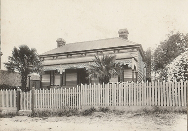
Photograph - T C WATTS & SON COLLECTION: 454 HARGREAVES STREET, BENDIGO, c.1928
... and Susan Watts. Before the real estate business commenced, Thomas... and Susan Watts. Before the real estate business commenced, Thomas ...Thomas Crouch Watts was born on March 7th. 1865, to Joseph and Susan Watts. Before the real estate business commenced, Thomas and his brother were in partnership as booksellers and stationers in a shop at View Point. Thomas lived in a fine house in Rowan Street, which was called 'Ottawa' Thomas started his real estate business in the early 1900s in a shop in View Street. His daughter Edna was the book keeper and typist, Stewart Watson was the salesman and Stanley Phipps (Edith Lunn's father) was the property manager and valuer. When Thomas Watts died in 1914, his daughter took over the running of the business. She married Stewart Watson in 1918. Eventually the name of the business was changed to Bishop and Earl. From a letter from Edith Lunn re T.C. Watts & Son. 'The firm of T.C. Watts & Son later became Bishop and Earl. When the firm of Bishop and Earl ceased to operate after the death of Edith Lunn's father, S.P. Bishop, Miss. June Parry, Secretary of the BHS was a member of staff. June rescued all the photos of properties listed for sale from the office and placed them into the custody of the BHS.'Black and white original photographs (2) mounted on rectangular grey board. House, weatherboard and roughcast, tiled roof, porch, wooden fence, 1 chimney, small paned windows with lead lights, 'Beware of the dog' sign. House name 'Loloma' Car in back in driveway on left. On rear of photo : 454 Hargreaves Street, Bendigo. A. Lienhop, £2500. 2012 photo of house attached to record.Frank A. Jeffries Bendigo Vic.place, building, residential -
 Ringwood and District Historical Society
Document - Land Sale Folder, Auburn Grove Estate Ringwood East - 2011-2013
... - Carter Real Estate, 90 Maroondah Highway, Ringwood Vic 3134... - Carter Real Estate, 90 Maroondah Highway, Ringwood Vic 3134 ...Folder containing flyers and multi-fold colour pamphlet advertising Auburn Grove Estate with maps and layout of subdivision and photographs of area. Flyers for First Release Auction 6 August, 2011 enclosed, and Second and Final Release Private Sale flyer with copy showing handwritten sale prices.Estate plan includes Auburn Grove off Longview Road and adjoining Tintern Grammar School, Ringwood East, Vic. Agents - Carter Real Estate, 90 Maroondah Highway, Ringwood Vic 3134. Phone 9870 6211 Fax 9870 6024. Accompanying folder includes handwritten auctioneer's notation (Richard Carter) on the name, that Auburn Grove Estate is adjacent to Tintern Farm - Tintern School originally having moved to Ringwood East from Auburn, Melbourne (1953). -
 Kew Historical Society Inc
Plan - Subdivision : Cotham and Glenferrie Roads, J R Mathers & McMillan
... a substantial number of real estate subdivision plans, mainly of Kew... number of real estate subdivision plans, mainly of Kew but also ...The Kew Historical Society's map collection includes a substantial number of real estate subdivision plans, mainly of Kew but also of surrounding suburbs in Melbourne. Most of the subdivision plans date from the 1920s and 1930s when the districts old homes and local farmland were being split up to accommodate residential growth in the postwar period. These early plans were assembled by a local firm, Jas R Mather & McMillan, which had an office in Cotham Road. Many of the plans, and sometimes photos, were annotated by the agents.Subdivision plans are historically important documents used as evidence for the growth of suburbs in Australia. They frequently provide information about when the land was sold as well as evidence relating to surveyors and real estate and financial agents. The numerous subdivision plans in the Kew Historical Society's collection represent working documents, ranging from the initial sketches made in planning a subdivision to printed plans on which auctioneers or agents listed the prices for which individual lots were sold. In a number of cases, the reverse of a subdivision plan in the collection includes a photograph of a house that was also for sale by the agent. These photographs provide significant heritage information relating house design and decoration, fencing and household gardens.The photograph may also be aesthetically significant depending on the importance of the photographic atelier.An undated and untitled hand-drawn and coloured subdivision plan detailing the boundaries of a number of irregular allotments bordering Cotham Road, Glenferrie Road and Stirling Avenue (now Stirling Street). The plan predates the actual subdivision that led to the creation of the eight commercial properties occupying 118-132 Cotham Road. The plan may represent an old subdivision that was further subdivided at a later date, or it may be a subdivision that never eventuated. On MMBW Detail Plan 1575 (1903), the area represented by the proposed subdivision was residential rather than commercial. The irregularity of lots is also apparent in the MMBW Plan. The largest of the unnumbered blocks on the hand-drawn subdivision plan may relate to the boundaries of the nineteenth century mansion identified as ‘Kelso’ on the MMBW Plan.subdivision plans - kew, cotham road - kew,, glenferrie road - kew , stirling avenue street - kew -
 Kew Historical Society Inc
Plan - Subdivision Plan, J R Mathers & McMillan, Myrtle Hill Estate, East Kew, circa 1949, c.1949
... a substantial number of real estate subdivision plans, mainly of Kew... number of real estate subdivision plans, mainly of Kew but also ...The Kew Historical Society's map collection includes a substantial number of real estate subdivision plans, mainly of Kew but also of surrounding suburbs in Melbourne. Most of the subdivision plans date from the 1920s and 1930s when the districts old homes and local farmland were being split up to accommodate residential growth in the postwar period. These early plans were assembled by a local firm, Jas R Mather & McMillan, which had an office in Cotham Road. Many of the plans, and sometimes photos, were annotated by the agents.Subdivision plans are historically important documents used as evidence for the growth of suburbs in Australia. They frequently provide information about when the land was sold as well as evidence relating to surveyors and real estate and financial agents. The numerous subdivision plans in the Kew Historical Society's collection represent working documents, ranging from the initial sketches made in planning a subdivision to printed plans on which auctioneers or agents listed the prices for which individual lots were sold. In a number of cases, the reverse of a subdivision plan in the collection includes a photograph of a house that was also for sale by the agent. These photographs provide significant heritage information relating house design and decoration, fencing and household gardens.The photograph may also be aesthetically significant depending on the importance of the photographic atelier.Myrtle Hill, at 14 Vista Avenue, Kew, is of local historical and architectural significance as a good example of a large and imposing single-storey Italianate house of the early 1870s surviving in Kew. Originally sited on a large allotment overlooking Normanby Road, the setting of the house has been dramatically altered through extensive subdivision and development. The subdivision plan of the ‘Myrtle Hill Estate’ indicates that in one such subdivision, 11 allotments were created fronting Bowyer Avenue, Myrtle Avenue, and Normanby Road. The outline and building profile of Myrtle Hill is shown on the west side of Bowyer Avenue.The full (typed) title of this subdivision plan is :"Plan of SUBDIVISION of part of CROWN PORTION 83. / at KEW / PARISH OF BOROONDARA. / COUNTY OF BOURKE". / "MYRTLE HILL ESTATE / EAST KEW" In addition to the Title and subtitle, the plan also lists the advantages of the subdivision. -
 Kew Historical Society Inc
Plan - Subdivision Plan, J R Mathers & McMillan, Normanby Estate, c.1913
... a substantial number of real estate subdivision plans, mainly of Kew... number of real estate subdivision plans, mainly of Kew but also ...The Kew Historical Society's map collection includes a substantial number of real estate subdivision plans, mainly of Kew but also of surrounding suburbs in Melbourne. Most of the subdivision plans date from the 1920s and 1930s when the districts old homes and local farmland were being split up to accommodate residential growth in the postwar period. These early plans were assembled by a local firm, Jas R Mather & McMillan, which had an office in Cotham Road. Many of the plans, and sometimes photos, were annotated by the agents.Subdivision plans are historically important documents used as evidence for the growth of suburbs in Australia. They frequently provide information about when the land was sold as well as evidence relating to surveyors and real estate and financial agents. The numerous subdivision plans in the Kew Historical Society's collection represent working documents, ranging from the initial sketches made in planning a subdivision to printed plans on which auctioneers or agents listed the prices for which individual lots were sold. In a number of cases, the reverse of a subdivision plan in the collection includes a photograph of a house that was also for sale by the agent. These photographs provide significant heritage information relating house design and decoration, fencing and household gardens.The photograph may also be aesthetically significant depending on the importance of the photographic atelier.The Normanby Estate, which was adjacent to Normanby Road, Kew East, included thirty-one lots for sale. Streets on the subdivision plan include Adeney Avenue, Park Hill Road, Normanby Road, Weir Street and Wharton Street. Cotham Road and its tramway are shown nearby. The plan is interesting as it shows Wharton Street, named after the architect and town planner George Wharton, who was the first chairman of the Municipality of Kew. The street was to later be renamed Cecil Street. Also shown are proposed ‘Municipal Gardens’ where Parkhill Drive is now located."D" in top left corner. Stamped auctioneers contact details: "Jas. R. Mathers & Son & McMillan / Auctioneer & Land Salesmen, / 271 Collins Street / Melbourne" and Jas. R. Mathers / Estate & Financial Agent / Cotham Road / Kew".weir street - kew, wharton street - kew, normanby road - kew, cotham road - kew, municipal gardens - kew, park hill parkhill road - kew, braemar - kew, subdivision plans - kew -
 Kew Historical Society Inc
Plan, J R Mathers & McMillan, Sackville, Thomas & Lytton Streets, Kew, Twentieth Century
... a substantial number of real estate subdivision plans, mainly of Kew... number of real estate subdivision plans, mainly of Kew but also ...The Kew Historical Society's map collection includes a substantial number of real estate subdivision plans, mainly of Kew but also of surrounding suburbs in Melbourne. Most of the subdivision plans date from the 1920s and 1930s when the districts old homes and local farmland were being split up to accommodate residential growth in the postwar period. These early plans were assembled by a local firm, Jas R Mather & McMillan, which had an office in Cotham Road. Many of the plans, and sometimes photos, were annotated by the agents.Subdivision plans are historically important documents used as evidence for the growth of suburbs in Australia. They frequently provide information about when the land was sold as well as evidence relating to surveyors and real estate and financial agents. The numerous subdivision plans in the Kew Historical Society's collection represent working documents, ranging from the initial sketches made in planning a subdivision to printed plans on which auctioneers or agents listed the prices for which individual lots were sold. In a number of cases, the reverse of a subdivision plan in the collection includes a photograph of a house that was also for sale by the agent. These photographs provide significant heritage information relating house design and decoration, fencing and household gardens.The photograph may also be aesthetically significant depending on the importance of the photographic atelier.Lithographed subdivision plan for an un-named estate with 28 allotments facing Lytton, Sackville and Thomas Streets in Kew. The land would have originally formed part of the Dumaresq Estate. subdivision plans - kew, lytton street, sackville street, thomas street - kew -
 Kew Historical Society Inc
Plan - Subdivision Plan, Jas R Mathers Son & McMillan, Eastlawn Estate : East Kew Auction Sale, 1914
... a substantial number of real estate subdivision plans, mainly of Kew... number of real estate subdivision plans, mainly of Kew but also ...The Kew Historical Society's map collection includes a substantial number of real estate subdivision plans, mainly of Kew but also of surrounding suburbs in Melbourne. Most of the subdivision plans date from the 1920s and 1930s when the districts old homes and local farmland were being split up to accommodate residential growth in the postwar period. These early plans were assembled by a local firm, Jas R Mather & McMillan, which had an office in Cotham Road. Many of the plans, and sometimes photos, were annotated by the agents.Subdivision plans are historically important documents used as evidence for the growth of suburbs in Australia. They frequently provide information about when the land was sold as well as evidence relating to surveyors and real estate and financial agents. The numerous subdivision plans in the Kew Historical Society's collection represent working documents, ranging from the initial sketches made in planning a subdivision to printed plans on which auctioneers or agents listed the prices for which individual lots were sold. In a number of cases, the reverse of a subdivision plan in the collection includes a photograph of a house that was also for sale by the agent. These photographs provide significant heritage information relating house design and decoration, fencing and household gardens.The photograph may also be aesthetically significant depending on the importance of the photographic atelier.The ‘Eastlawn Estate’ was surveyed and ready for auction in March 1914, three months before the outbreak of World War I. Sixty-six allotments, created on the ‘order of Mr & Miss Preston’ surrounded the mansion of Woodlands in Harp Road. Woodlands formed part of the Estate, being advertised as lot 1. The allotments faced High, Station and Wright Streets, Harp and Normanby Roads, and Woodlands Avenue. Pru Sanderson in the Kew Conservation Study (Vol.2, 1988) wrote that the Eastlawn Estate ‘covered the western half of the failed Harp of Erin Estate’. Contemporary advertisements promoted the Eastlawn Estate as: ‘There will be no more convenient district nor pleasant Suburb than East Kew for the busy business man. When the Electric Tram is laid, he will be able to journey quickly and pleasantly direct from Collins Street to his home in the Eastlawn Estate in about 20 minutes’. The actual plans of subdivision were included in advertisements in The Argus and in the local newspapers."C" top left. Various annotations.subdivision plans - kew, station street, normanby road, high street, woodlands avenue, harp road, woodlands - kew -
 Kew Historical Society Inc
Plan - Subdivision Plan, Winton Estate, East Kew : Sale of 10 Building Blocks, 1920
... a substantial number of real estate subdivision plans, mainly of Kew... number of real estate subdivision plans, mainly of Kew but also ...The Kew Historical Society's map collection includes a substantial number of real estate subdivision plans, mainly of Kew but also of surrounding suburbs in Melbourne. Most of the subdivision plans date from the 1920s and 1930s when the districts old homes and local farmland were being split up to accommodate residential growth in the postwar period. These early plans were assembled by a local firm, Jas R Mather & McMillan, which had an office in Cotham Road. Many of the plans, and sometimes photos, were annotated by the agents.Subdivision plans are historically important documents used as evidence for the growth of suburbs in Australia. They frequently provide information about when the land was sold as well as evidence relating to surveyors and real estate and financial agents. The numerous subdivision plans in the Kew Historical Society's collection represent working documents, ranging from the initial sketches made in planning a subdivision to printed plans on which auctioneers or agents listed the prices for which individual lots were sold. In a number of cases, the reverse of a subdivision plan in the collection includes a photograph of a house that was also for sale by the agent. These photographs provide significant heritage information relating house design and decoration, fencing and household gardens.The photograph may also be aesthetically significant depending on the importance of the photographic atelier.Subdivision plan for the so-called Winton Estate in East Kew. The Estate comprised 10 lots facing Simpson Street and Campbell Street. The estate was auctioned by Jas. R. Mathers, Son and McMillan. campbell street, simpson street, hunter street, normanby road - kew, subdivision plans - east kew, subdivision plans - kew -
 Kew Historical Society Inc
Plan - Subdivision Plan, Argyle Road, Heather Grove, Victor Avenue, Kew, c.1937
... a substantial number of real estate subdivision plans, mainly of Kew... number of real estate subdivision plans, mainly of Kew but also ...The Kew Historical Society's map collection includes a substantial number of real estate subdivision plans, mainly of Kew but also of surrounding suburbs in Melbourne. Most of the subdivision plans date from the 1920s and 1930s when the districts old homes and local farmland were being split up to accommodate residential growth in the postwar period. These early plans were assembled by a local firm, Jas R Mather & McMillan, which had an office in Cotham Road. Many of the plans, and sometimes photos, were annotated by the agents.Subdivision plans are historically important documents used as evidence for the growth of suburbs in Australia. They frequently provide information about when the land was sold as well as evidence relating to surveyors and real estate and financial agents. The numerous subdivision plans in the Kew Historical Society's collection represent working documents, ranging from the initial sketches made in planning a subdivision to printed plans on which auctioneers or agents listed the prices for which individual lots were sold. In a number of cases, the reverse of a subdivision plan in the collection includes a photograph of a house that was also for sale by the agent. These photographs provide significant heritage information relating house design and decoration, fencing and household gardens.The photograph may also be aesthetically significant depending on the importance of the photographic atelier.Undated blue subdivision plan in Kew of 14 lots facing Argyle Road, Heather Grove and Victor Road. The Plan identifies Tuxen & Miller as the surveyors. [Formerly catalogued as MAP.0059]subdivision plans - kew, argyle road - kew, heather grove - kew, victor avenue - kew -
 Kew Historical Society Inc
Plan - Subdivision Plan, Riversdale Estate, 1939
... by persons connected with the real estate firm - J. R. Mathers... by persons connected with the real estate firm - J. R. Mathers ...The Kew Historical Society collection includes almost 100 subdivision plans pertaining to suburbs of the City of Melbourne. Most of these are of Kew, Kew East or Studley Park, although a smaller number are plans of Camberwell, Deepdene, Balwyn and Hawthorn. It is believed that the majority of the plans were gifted to the Society by persons connected with the real estate firm - J. R. Mathers and McMillan, 136 Cotham Road, Kew. The Plans in the collection are rarely in pristine form, being working plans on which the agent would write notes and record lots sold and the prices of these. The subdivision plans are historically significant examples of the growth of urban Melbourne from the beginning of the 20th Century up until the 1980s. A number of the plans are double-sided and often include a photograph on the reverse. A number of the latter are by noted photographers such as J.E. Barnes.The Riversdale Estate in Hawthorn created a subdivision of 20 allotments bordering on Riversdale Road and Riversdale Court (which was created by the subdivision). The Locality Plan at right lists the major public buildings in the area: Burnely Horticultural Gardens, Hawthorn Tram Depot and Railway Station, Scotch College and the River Yarra and The Boulevard.subdivision plans - hawthorn, riversdale estate -
 Kew Historical Society Inc
Plan - Subdivision Plan, Corsewall Estate, Hawthorn, 1938
... by persons connected with the real estate firm - J. R. Mathers... by persons connected with the real estate firm - J. R. Mathers ...The Kew Historical Society collection includes almost 100 subdivision plans pertaining to suburbs of the City of Melbourne. Most of these are of Kew, Kew East or Studley Park, although a smaller number are plans of Camberwell, Deepdene, Balwyn and Hawthorn. It is believed that the majority of the plans were gifted to the Society by persons connected with the real estate firm - J. R. Mathers and McMillan, 136 Cotham Road, Kew. The Plans in the collection are rarely in pristine form, being working plans on which the agent would write notes and record lots sold and the prices of these. The subdivision plans are historically significant examples of the growth of urban Melbourne from the beginning of the 20th Century up until the 1980s. A number of the plans are double-sided and often include a photograph on the reverse. A number of the latter are by noted photographers such as J.E. Barnes.This is a second, more complete version of the Corsewall Estate subdivision that is held by the Society. The Coreswall Estate was a subdivision, bordering on Barkers Road and Auburn Road, which created Corsewall Close. This relatively late subdivision included 29 allotments. The subdivision plan includes the dimensions of each lot as well as the width of the existing and projected roads and turning circles. The Corsewall Close Precinct is now listed on the Victorian Heritage Database (HO147) and is noted for its ‘consistent flat-type development over the entire street, which has been cleverly designed to make multi-unit dwellings appear as single buildings’. In this second version of the plan, the rarity of this late subdivision is emphasised by the auctioneers. The original plan must have contained a photograph, which is unfortunately truncated here.subdivision plans - hawthorn, corsewall estate -
 Kew Historical Society Inc
Plan - Subdivision Plan, Mount Ida Estate, 1925
... by persons connected with the real estate firm - J. R. Mathers... by persons connected with the real estate firm - J. R. Mathers ...The Kew Historical Society collection includes almost 100 subdivision plans pertaining to suburbs of the City of Melbourne. Most of these are of Kew, Kew East or Studley Park, although a smaller number are plans of Camberwell, Deepdene, Balwyn and Hawthorn. It is believed that the majority of the plans were gifted to the Society by persons connected with the real estate firm - J. R. Mathers and McMillan, 136 Cotham Road, Kew. The Plans in the collection are rarely in pristine form, being working plans on which the agent would write notes and record lots sold and the prices of these. The subdivision plans are historically significant examples of the growth of urban Melbourne from the beginning of the 20th Century up until the 1980s. A number of the plans are double-sided and often include a photograph on the reverse. A number of the latter are by noted photographers such as J.E. Barnes.The Mount Ida Estate was a subdivision of fifty-two residential allotments bordering Tooronga Road, Leura Grove, Constance Street, and Mount Ida Avenue in Hawthorn East. The report of the sale of the Estate in The Argus (21 September) claimed that over 1,000 people attended the auction and that all allotments were sold on the day. On the other side of Constance Street, the plan identifies the ‘Eastern Recreation Reserve’ (now Anderson Park).subdivision plans - hawthorn -
 Kew Historical Society Inc
Plan - Subdivision Plan, Jaques Estate, 1927
... by persons connected with the real estate firm - J. R. Mathers... by persons connected with the real estate firm - J. R. Mathers ...The Kew Historical Society collection includes almost 100 subdivision plans pertaining to suburbs of the City of Melbourne. Most of these are of Kew, Kew East or Studley Park, although a smaller number are plans of Camberwell, Deepdene, Balwyn and Hawthorn. It is believed that the majority of the plans were gifted to the Society by persons connected with the real estate firm - J. R. Mathers and McMillan, 136 Cotham Road, Kew. The Plans in the collection are rarely in pristine form, being working plans on which the agent would write notes and record lots sold and the prices of these. The subdivision plans are historically significant examples of the growth of urban Melbourne from the beginning of the 20th Century up until the 1980s. A number of the plans are double-sided and often include a photograph on the reverse. A number of the latter are by noted photographers such as J.E. Barnes.The Jaques Estate was a small subdivision of eight residential allotments bordering Jaques Street and Barkers Road in what is now Hawthorn East. Advertised in The Argus as being in ‘Upper Hawthorn’ the subdivision was claimed to include: ‘charming villa sites in excellent situations, with every convenience available, and with superior homes surrounding’.subdivision plans - hawthorn, jaques estate -
 Kew Historical Society Inc
Plan - Subdivision Plan, Houghton Street & Buchanan Avenue, Balwyn North, ca. 1906
... by persons connected with the real estate firm - J. R. Mathers... by persons connected with the real estate firm - J. R. Mathers ...The Kew Historical Society collection includes almost 100 subdivision plans pertaining to suburbs of the City of Melbourne. Most of these are of Kew, Kew East or Studley Park, although a smaller number are plans of Camberwell, Deepdene, Balwyn and Hawthorn. It is believed that the majority of the plans were gifted to the Society by persons connected with the real estate firm - J. R. Mathers and McMillan, 136 Cotham Road, Kew. The Plans in the collection are rarely in pristine form, being working plans on which the agent would write notes and record lots sold and the prices of these. The subdivision plans are historically significant examples of the growth of urban Melbourne from the beginning of the 20th Century up until the 1980s. A number of the plans are double-sided and often include a photograph on the reverse. A number of the latter are by noted photographers such as J.E. Barnes.A hand-drawn subdivision plan listing six blocks bounded by Houghton Street, Doncaster Road, Buchanan Avenue and Maud Street, North Balwyn. Written on the plan of subdivision are the lot numbers, the dimensions of the blocks and the price at which two lots were for sale or had been sold for.subdivision plans - balwyn -
 Kew Historical Society Inc
Plan - Subdivision Plan, Doona Estate, Toorak, 1929
... by persons connected with the real estate firm - J. R. Mathers... by persons connected with the real estate firm - J. R. Mathers ...The Kew Historical Society collection includes almost 100 subdivision plans pertaining to suburbs of the City of Melbourne. Most of these are of Kew, Kew East or Studley Park, although a smaller number are plans of Camberwell, Deepdene, Balwyn and Hawthorn. It is believed that the majority of the plans were gifted to the Society by persons connected with the real estate firm - J. R. Mathers and McMillan, 136 Cotham Road, Kew. The Plans in the collection are rarely in pristine form, being working plans on which the agent would write notes and record lots sold and the prices of these. The subdivision plans are historically significant examples of the growth of urban Melbourne from the beginning of the 20th Century up until the 1980s. A number of the plans are double-sided and often include a photograph on the reverse. A number of the latter are by noted photographers such as J.E. Barnes.The Doona Estate subdivision of 1929 created 11 new allotments bordered by Glenferrie Road, Stonnington Place, Cross and Church Streets. On the right of the plan, the location of ‘State Govt. House’ is noted. Stonnington was to be maintained as Victoria’s Government House until 1931, two years after the Doona Estate subdivision was released.subdivision plans - toorak, doona estate -
 Kew Historical Society Inc
Plan - Subdivision Plan, Auburn Heights Estate, 1921
... by persons connected with the real estate firm - J. R. Mathers... by persons connected with the real estate firm - J. R. Mathers ...The Kew Historical Society collection includes almost 100 subdivision plans pertaining to suburbs of the City of Melbourne. Most of these are of Kew, Kew East or Studley Park, although a smaller number are plans of Camberwell, Deepdene, Balwyn and Hawthorn. It is believed that the majority of the plans were gifted to the Society by persons connected with the real estate firm - J. R. Mathers and McMillan, 136 Cotham Road, Kew. The Plans in the collection are rarely in pristine form, being working plans on which the agent would write notes and record lots sold and the prices of these. The subdivision plans are historically significant examples of the growth of urban Melbourne from the beginning of the 20th Century up until the 1980s. A number of the plans are double-sided and often include a photograph on the reverse. A number of the latter are by noted photographers such as J.E. Barnes.The name ‘Auburn Heights Estate’, was handwritten on the subdivision plan, and included 23 lots in Auburn Road and Wright and View Streets, Hawthorn. Most of the houses built on the lots that were sold still exist. The house built on number 8 View Street is a contemporary exception. The subdivision included an existing home at number 17 View Street.subdivision plans - hawthorn, auburn heights estate