Showing 7119 items matching "snowy-river"
-
 Eltham District Historical Society Inc
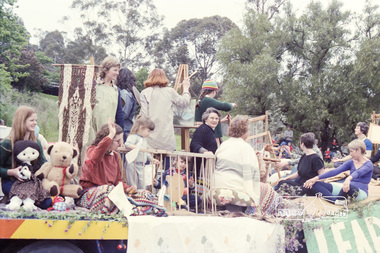
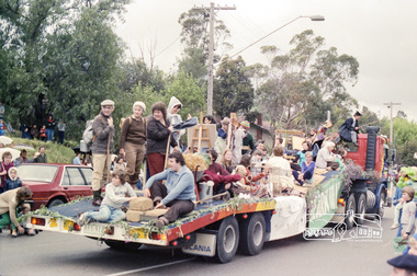
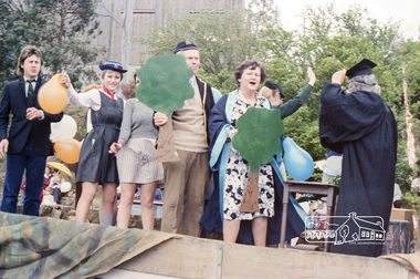
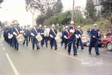
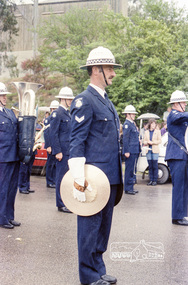
Photograph, Eltham Festival Parade, Nov 1982, 1982
Roll of negatives of the Eltham Festival Parade as it progresses along Main Road past the Catholic Church heading towards Bridge Street. Floats included the Tasmanian Wilderness Society with the Save the Franklin River campaign, and Diamond Valley Railway celebrating 21 years of passenger service as well as the Victorian Police Marching Band. A well known Eltham identity, Jock Read was asked to lead the Eltham Pony Club contingent that year and the roll includes several shots of Jock on his horse, Lofty who was approximately ten years of age, his colour was still classed as a steel grey at the time before he went "white" quite a few years later.Roll of 35mm colour negative film, 24 shotsKodak Safety Film 5035eltham festival -
 Eltham District Historical Society Inc
Photograph, Eltham Festival Parade, Nov 1982, 1982
Roll of negatives of the Eltham Festival Parade as it progresses along Main Road past the Catholic Church heading towards Bridge Street. Floats included the Tasmanian Wilderness Society with the Save the Franklin River campaign, and Diamond Valley Railway celebrating 21 years of passenger service as well as the Victorian Police Marching Band. A well known Eltham identity, Jock Read was asked to lead the Eltham Pony Club contingent that year and the roll includes several shots of Jock on his horse, Lofty who was approximately ten years of age, his colour was still classed as a steel grey at the time before he went "white" quite a few years later.Roll of 35mm colour negative film, 24 shotsKodak Safety Film 5035eltham festival -
 Federation University Historical Collection
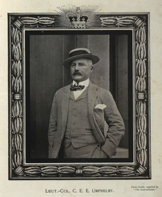
Photograph - black and white, Lieutenant-Colonel Charles Umphelby, 1900
Charles Umphelby began his military career at Warrnambool Garrison in 1884. In 1885 he was appointed Lieutenant in the Victorian Permanent Artillery. He succeeded Major Daniel in command of Queenscliff Fort in 1890. He went to England in 1889 and was attached to the staff of Major-General Clarke. Lieutenant-Colonel Charles Umphelby was a Special Service Officer attached to the Censor's Department in Cape Town. He then went to the Howitzer Division of Lord Methuen's force at Modder River. Charles was wounded during the fight at Driefontein, 10 March and died 12 March 1900. He was married to the daughter of Thomas Austin, owner of Barwon Park near Geelong. They had two daughters.Digital portrait from "In Memory of the Gallant Officers and Men of Victoria in Transvaal War, 1899-1900".charles umphelby, warrnambool garrison, victorian permanent artillery, major daniel, queenscliff fort, major-general clarke, cape town, howitzer division, lord methuen, modder river, dreifontein, thomas austin, barwon park -
 Tatura Irrigation & Wartime Camps Museum
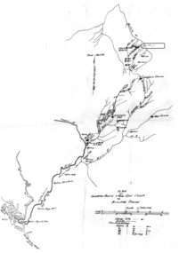
Map - Map - Photocopy, New Guinea Escape Route
At the end of January 1942 there was only about 250 men left in Wau, as the women and children had been evacuated by air a little earlier. With no planes to take the men they had to make their own way to Port Moresby and then travel by ship to Australia. Some men went down to Salamaua and made their way along the north coast, but small groups also made their way over the Owen Stanley Ranges; rafting down the Lakekamu RIver to Yule Island and by boat to Port Moresby. Donor Vanessa Kiessling's Father was part of the second group, and had drawn a detailed map of their route. This might be the same route taken by Rev. Willi Hertle (Ref C0750)Photocopy of New Guinea map showing escape routePlan of surveyed route from Edie Creek to Bulldog Dromepapua new guinea, escape, map, wau, willi hertle, kiessling -
 Bacchus Marsh & District Historical Society
Map, Plan of Land at Bacchus Marsh, the Property of James Young, 1868
James Young was a prominent businessman, land owner and public figure in the early colonial period of Bacchus Marsh. In February 1868 he offered for sale through the agent W. Anderson 38 blocks of land which ran from the Lerderderg RIver westwards beyond Gisborne Road in the vicinity of the present day Masons Land. The land for sale was described as, 'unsurpassed Agricultural Land, in the immediate vicinity of Bacchus Marsh, varying in size from 2 to 12 acres each'. The sale notice in the Bacchus Marsh Express of 1st February 1868 page 2, also noted that, ' Plans can be seen at Mr. Young's Border Mills Store, and at the Border Inn'. One of the largest and most important land sales in the early colonial period of Bacchus Marsh.A single page paper map showing 38 blocks of land for sale in 1868 in the vicinity of Masons Lane Bacchus Marsh. Scale 11 chains to 1 inch. The map is pasted into a bound volume containing 76 maps or plans in total. High resolution digital image stored on BMDHS computer network. land sales bacchus marsh, bacchus marsh victoria maps, james young 1816-1871, masons lane bacchus marsh land sales -
 Warrnambool and District Historical Society Inc.
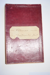
Administrative record - Warrnambool Water Trust Notebook, late 19th century (1892-1900)
This notebook appears to be the Warrnambool Water Trust Records of two contracts in 1892 . (The reference is written as 'W.W.Trust'.) The first contract, with the contractors, Coates and Reed, is for the excavation for settling tanks and clear water basin and a reservoir in Liebig Street and there are 60 pages giving details of these works - labour, masonry, concreting, fencing etc. The second contract with the contractor, William Kellas, is for the erection of a cottage and an engine shed and boiler room (7 pages). The Warrnambool Water Trust was set up in 1891 and the first project was the supply of water from the Merri River near Wollaston to a reservoir and tower in Liebig Street and this notebook concerns some details of this early water supply scheme. This notebook is of some interest as it supplies details of a late 19th century Warrnambool water supply scheme and so should be of value to local history researchers This is a notebook with a red leather cover and pages with printed headings and ruled red lines. The pages contain handwriting in black ink. The cover has a label (partly torn) with handwriting.Returns Contracts 1 & 2warrnambool water supply, warrnambool water board, 19th century water in warrnambool -
 Bendigo Military Museum
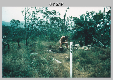
Photograph - Royal Australian Survey Corps Surveyors in the Field – North Queensland and Torres Strait, 1961
This is a set of five photographs of surveyors and support staff in the field undertaking duties in North Queensland and Torres Strait in 1961. The surveyors were employed in the establishment of mapping and geodetic control. In this era surveyors used theodolites to observe horizontal and vertical angles and tellurometers to measure base line distances between survey stations. In photo .2P Joe Farrington is seen taking survey observations using a Tavistock V500 Series Tavistock theodolite at a survey station between the Edward River and Aurukun in the Cape York Peninsula. The Gulf of Carpentaria appears in the background. From 1957 helicopter transport of survey parties revolutionised transport in remote areas. The civilian helicopter was hired from TAA. This is a set of five photographs of surveyors and support staff in the field undertaking duties in North Queensland and Torres Strait in 1961. The photographs were printed on photographic paper and are part of the Army Survey Regiment’s Collection. The photographs were scanned at 300 dpi. .1) - Photo, colour, 1961. Andy Millar occupying a survey station on a hill in the Cape York Peninsula, QLD. .2) - Photo, colour, 1961. Joe Farrington taking observations with a V500 Series Tavistock geodetic theodolite at a survey station in the Cape York Peninsula, QLD. .3) - Photo, colour, 1961. Daryl Parker taking a break from survey observations on a hill located on Duaun Island QLD, in the Torres Strait, a few miles south of the PNG coastline. Hill height was 975 ft. .4) - Photo, colour, 1961. Three Torres Strait divers L to R: unidentified, Darku and Ray Mau Daryl standing behind a Tavistock geodetic theodolite on a hill located on Duaun Island QLD, in the Torres Strait, a few miles south of the PNG coastline. .5) - Photo, colour, 1961. Andy Millar holding meat from a small turtle on Duaun Island QLD, in the Torres Strait, a few miles south of the PNG coastline. An unidentified Duaun Island local appears in the background..1P to .5P annotated on back – personnel names, the year and the location. royal australian survey corps, rasvy, army survey regiment, asr, army svy regt, fortuna, surveying -
 Bendigo Historical Society Inc.
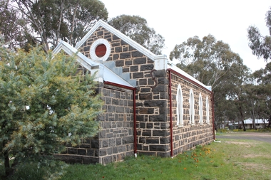
Document - Notes on St Andrews Church Axedale, 1st Sept 2024
Although Presbyterians held religious services prior to 1854 it, was not till that year that Dr Nish arrived in Bendigo. It is known that Dr Nish preached to the shepherds in Axedale, long before the church was built, but where is not known. The foundation stone for the church was lain on September 30th, 1868. Axedale is a town in Victoria, Australia. It is located on the McIvor Highway, in the City of Greater Bendigo, east of Bendigo. It was surveyed and proclaimed in 1861. At the 2021 census, Axedale had a population of 984. The town is nestled alongside the Campaspe River which feeds out of Lake Eppalock. It has a golf course, tennis courts, a school, a pub and a convenience store/petrol station. It lies between Heathcote and Bendigo.Historical Notes on St Andrews Axedale 1868-1968 and the 150th Anniversary Church booklet March 2019.axedale, st andrews church axedale, dr nish -
 Melbourne Tram Museum
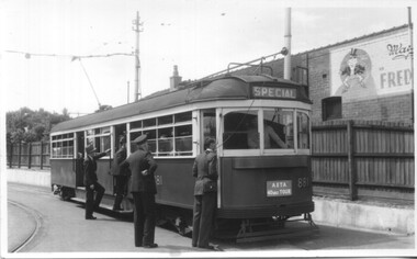
Photograph - Set of 5 Black & White - First AETA tour, 15-2-1947
Set of five photographs of the first Australian Electric Traction Association (AETA) tram tour of Melbourne on 15/2/1947. See page 8 of the March 1947 issue of "Tram Tracks" for details of the tour and the MMTB Crew. 1 - SW6 881 about to leave Glen Huntly Depot 2 - Crossing Balaclava Junction 3 - Crossing the Kooyong railway level crossing in Glenferrie Road - has the railway signal box and gates in view. 4 - Turning into Riversdale Road from Glenferrie Road with the Stotts Business College building in the background. 5 - Just to the east of Yarra River Bridge in Swan Street with the Burnley Gardens on the right.Yields information about the first AETA tram tour in 1947Set of 5 Black and white photograph on paper. Two copies of each held.Each one of the set has a photographers file stamp on the rear, but no details filled in.trams, tramways, aeta, tram tours, tram 881, sw6 class, glen huntly, kooyong level crossing, glenferrie road, riversdale road, burnley, hawthorn, balaclava junction, glen huntly depot, hawthorn road, swan st -
 Stawell Historical Society Inc
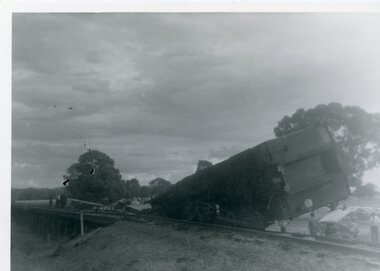
Photograph, Train Derailment near Glenorchy February 1971-- 6 Photos, 1971
Series of six photographs of Train derailment near Glenorchy February 1971. These Photographs are copies o=from negatives held by the society - Made possible by grant 1991. These photographs taken of a train accident. The Afternoon Passenger Train - at the level crossing on the Warracknabeal - Stawell Road. There are 2 crossings on the road - This crossing is near the Wimmera River Rail Bridge. The cause of the accident - was a collision between a loaded Gravel truck and the passenger train. The Driver of the Truck was killed. 1231-2 B/w Photo of Train Smash near Glenorchy. This photo was donated from the estate of Mr Boothey in 2010, and is almost identical to one in 1231. This Photo is in album 4. B/W Photos of a Train Smash - 1231 The deisel Engine completely derailed off the rail line. 1231-1 showing the derailed rolling stock from another angle. Many onlookers. 1231-2 The Boogie is completely off the carriage 3 Photogrpahsstawell railways transport, glenochy -
 Eltham District Historical Society Inc
Photograph, Henley Bridge, Spring Excursion, Exploring the Upper Yarra, 22 October 1995, 22/10/1995
[article by Bettina Woodburn in EDHS Newsletter No. 105, November 1995:] EXPLORING THE UPPER YARRA - We enjoyed the Spring Excursion, this year "Exploring the Upper Yarra" - in spite of the constant rain and the countryside under the cloud cover, especially in the valleys, being mainly shiny shades of green. The occasional fields of buttercups, clumps of arum lilies and splendid rhododendron and other flowering bushes became very special. The Cobb and Co coach was warm and a cosy retreat as we zig-zagged on the highways and byways to glimpse the Yarra River, upstream and down, its secret places, and particularly the many bridges. Russell excelled as 'Poet Laureate', reading from Dacre Smyth's book. This 1979 publication includes paintings of all the bridges along the river with poems and brief descriptions of each one. Some of the bridges are in out-of-the-way places and are not very well known. We looked forward to hearing the poetry as much as seeing the 'constructions'… Big Pat (was he short or tall, lean or fat? - he did win the £200 reward for discovering gold and had the creek named after him), about the 'Eddies'?, and the disliked 'meccano' bridge in Warburton, etc. etc. The hot roast lunch in the old Reefton Hotel was also most welcome. It was easy to imagine it peopled by miners and early settlers. Starting by crossing the new (1974) concrete bridge at Warrandyte we headed through Wonga Park with views to the Christmas Hills and to the escarpment of the Yering Gorge, which causes flood waters to back up through the Yarra Glen plain, so avoiding disasters downstream. At the end of a long driveway we found the wooden, privately owned Henley Bridge (1935 after the 1934 floods). This facilitates access to different parts of Henley Farm and to Lilydale. Everard Park, named after Blanche Shallard's father, a State Member for 17 years, below the Highway Yarra crossing was in need of care. It is 10 miles from Yarra Glen by road but, as "Yarra Marra” canoeists well know, 32 winding miles down by water. After more delightful countryside scenes we joined the Warburton Highway at Woori Yallock. From the old Railway Station at Launching Place the Centennial Trail for walkers, cyclists and horse riders has replaced the rails. The line from Lilydale was opened in 1901, and the last diesel freight train ran to Warburton in 1965. It continued to rain as we had morning tea in Warburton in a shelter between footbridges. From here we continued upstream past the Bridge to O'Shannassy Lodge and Reservoir, Starvation Creek, and the Peninsular tunnel (miners dug it as at Pound Bend) which we visited (scrambling down those steps!) on our return after lunch. Our furthermost point was the Upper Yarra Dam Reserve (and vast catchment area). Finished in 1957 after ten years' work and 100 years after Yan Yean, it supplies much of Melbourne's water. After crossing the 30m Launching Place Bridge to the Eltham side of the Yarra and Healesville, we saw in the distance the Yarra Glen Timber Trestle Bridge over the river flats "the longest for years in the land it was said!" Harry's dream of "better weather over the Divide" unfortunately didn't come true, but I'm sure we 36 members will retain happy memories of a day that was wet and green and filled with Bridges. Situated on the Yarra River, 5.5 kms south of Christmas Hills on private property. This timber trestle bridge is said to have been built some time after 1907 by Melbourne master-builder, David Mitchell (the father of Dame Nellie Melba), to connect his two "Henley Farm" properties with Lilydale. In earlier days, when the McPhersons owned the property, their children used a punt to cross the river to attend Yering Primary School. This private bridge is best viewed from the end of Wendy Way. - Source: Christmas Hills Past and Present, Yarra Glen & District Historical Society, 2004.Two colour photographsactivities, henley bridge, upper yarra -
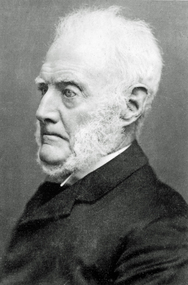
 Camperdown & District Historical Society
Photograph - James Dawson, Thomas Rodger, c1881
James Dawson (1806-1900), pastoralist, friend to First Nations people, environmentalist, patron of the Arts and author of "Australian Aborigines" (1881). Dawson came from Bonnytoun, near Linlithgow, Scotland and arrived in Melbourne with his wife, Joan Alexander Park, on 2 May 1840. They made their first home in the colony farming in Port Phillip, near Anderson's Creek on the Yarra River, where their daughter, Isabella was born in 1842, then from 1844, moved to 'Kangatong' station on the Moyne River, east of Macarthur. In 1866 the Dawsons left the Port Fairy district and lived in various residences in Melbourne. By 1868 the family had settled in Camperdown at 'Wuurong', on the banks of Lake Bullen Merri. Unlike most people at the time, Dawson and his daughter shared a deep interest in, and respect for First Nations people. In 1876 James Dawson was appointed local Guardian of the Aborigines in the Camperdown district. He was a prolific letter writer and an early advocate for indigenous rights and was dedicated to exposing injustice and the maltreatment of First Nations people. He had befriended Wombeetch Puyuun (Camperdown George) who was the last of the local Djargurd Wurrung living on Country when he died in February 1883. In 1885 James Dawson erected the Wombeetch Puyuun Monument at Camperdown Cemetery in his memory. His friend's remains were reburied at the foot of the obelisk and the two dates, 1840-1883, mark the 43 years it took for European settlement to displace the Djargurd Wurrung from the Camperdown District.Sepia photograph of an elderly James Dawson taken in Scotland. Front: T. Rodger St. ANDREWS N.B. Back: THOMAS RODGER Photographer ST. ANDREWS ETABLISHED 1849cdhs, isabella dawson, camperdown cemetery, djargurdwurrung, cdhsfirstnations -
 Camperdown & District Historical Society
Book - The James Dawson Scrapbook, c1881
James Dawson (1806-1900), pastoralist, friend to First Nations people, environmentalist, patron of the Arts and author of "Australian Aborigines" (1881). Dawson came from Bonnytoun, near Linlithgow, Scotland and arrived in Melbourne with his wife, Joan Alexander Park, on 2 May 1840. They made their first home in the colony farming in Port Phillip, near Anderson's Creek on the Yarra River, where their daughter, Isabella was born in 1842, then from 1844, moved to 'Kangatong' station on the Moyne River, east of Macarthur. In 1866 the Dawsons left the Port Fairy district and lived in various residences in Melbourne. By 1868 the family had settled in Camperdown at 'Wuurong', on the banks of Lake Bullen Merri. Unlike most people at the time, Dawson and his daughter shared a deep interest in, and respect for First Nations people. In 1876 James Dawson was appointed local Guardian of the Aborigines in the Camperdown district. He was a prolific letter writer and an early advocate for indigenous rights and was dedicated to exposing injustice and the maltreatment of First Nations people. He had befriended Wombeetch Puyuun (Camperdown George) who was the last of the local Djargurd Wurrung living on Country when he died in February 1883. In 1885 James Dawson erected the Wombeetch Puyuun Monument at Camperdown Cemetery in his memory. His friend's remains were reburied at the foot of the obelisk and the two dates, 1840-1883, mark the 43 years it took for European settlement to displace the Djargurd Wurrung from the Camperdown District.The James Dawson Scrapbookcdhs, isabella dawson, camperdown cemetery, djargurdwurrung, cdhsfirstnations -
 Camperdown & District Historical Society
Photograph - James and Joan Dawson, studio photograph, c1878
James Dawson (1806-1900), pastoralist, friend to First Nations people, environmentalist, patron of the Arts and author of "Australian Aborigines" (1881). He married Joan Alexander Park in 1877. Joan was the niece of the famous African explorer, Mungo Park. James Dawson came from Bonnytoun, near Linlithgow, Scotland and arrived in Melbourne with his wife on 2 May 1840. They made their first home in the colony farming in Port Phillip, near Anderson's Creek on the Yarra River, where their daughter, Isabella was born in 1842, then from 1844, moved to 'Kangatong' station on the Moyne River, east of Macarthur. In 1866 the Dawsons left the Port Fairy district and lived in various residences in Melbourne. By 1868 the family had settled in Camperdown at 'Wuurong', on the banks of Lake Bullen Merri. Unlike most people at the time, the Dawson's shared a deep interest in, and respect for First Nations people. In 1876 James Dawson was appointed local Guardian of the Aborigines in the Camperdown district. He was a prolific letter writer and an early advocate for indigenous rights and was dedicated to exposing injustice and the maltreatment of First Nations people. He had befriended Wombeetch Puyuun (Camperdown George) who was the last of the local Djargurd Wurrung living on Country when he died in February 1883. In 1885 James Dawson erected the Wombeetch Puyuun Monument at Camperdown Cemetery in his memory. His friend's remains were reburied at the foot of the obelisk and the two dates, 1840-1883, mark the 43 years it took for European settlement to displace the Djargurd Wurrung from the Camperdown District.Studio portrait of James and Joan Dawson taken in Australia. cdhs, isabella dawson, camperdown cemetery, djargurdwurrung, cdhsfirstnations -
 Camperdown & District Historical Society
Photograph - James Dawson, c1878
James Dawson (1806-1900), pastoralist, friend to First Nations people, environmentalist, patron of the Arts and author of "Australian Aborigines" (1881). Dawson came from Bonnytoun, near Linlithgow, Scotland and arrived in Melbourne with his wife, Joan Alexander Park, on 2 May 1840. They made their first home in the colony farming in Port Phillip, near Anderson's Creek on the Yarra River, where their daughter, Isabella was born in 1842, then from 1844, moved to 'Kangatong' station on the Moyne River, east of Macarthur. In 1866 the Dawsons left the Port Fairy district and lived in various residences in Melbourne. By 1868 the family had settled in Camperdown at 'Wuurong', on the banks of Lake Bullen Merri. Unlike most people at the time, Dawson and his daughter shared a deep interest in, and respect for First Nations people. In 1876 James Dawson was appointed local Guardian of the Aborigines in the Camperdown district. He was a prolific letter writer and an early advocate for indigenous rights and was dedicated to exposing injustice and the maltreatment of First Nations people. He had befriended Wombeetch Puyuun (Camperdown George) who was the last of the local Djargurd Wurrung living on Country when he died in February 1883. In 1885 James Dawson erected the Wombeetch Puyuun Monument at Camperdown Cemetery in his memory. His friend's remains were reburied at the foot of the obelisk and the two dates, 1840-1883, mark the 43 years it took for European settlement to displace the Djargurd Wurrung from the Camperdown District.Side portrait of an elderly James Dawson. cdhs, isabella dawson, camperdown cemetery, djargurdwurrung, cdhsfirstnations -
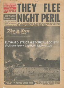 Eltham District Historical Society Inc
Newspaper - Newspaper articles, Sun News-Pictorial, They Flee Night Peril, The Sun News-Pictorial, Wednesday, January 17, p1, 1962
Various news articles pertaining to the January 1962 Victorian bushfires in the Dandenong and Healesville districts which by the third day had encompassed large areas of the State. Specific Eltham Shire districts mentioned include Panton Hill and Hurstbridge on page 1, Warrandyte on page 2, 3, 4 and 5, Hurstbridge, Smith’s Gully, Kinglake on page 3 and 4, Strathewen, Kangaroo Ground, Panton Hill, St. Andrews, Smith’s Gully on page 4 and Pound Bend, Smith’s Gully and Warrandyte on pages 20-21 • They Flee Night Peril, p1 (Illust.) • Their grim picnic; A flash fire strikes, p2 (Illust.) • Night of terror as towns quitted, p3 • Fought till he dropped, p3 (Illust.) • Rain in fire area, p3 • Wye River town goes, p3 • Black Friday Hero Dies In Fire; with wife, grandsons, p4 • Surrounded!, p4 (Illust.) • Main street houses ablaze, p4 • Hurstbridge is evacuated, p4 • Scores jump in river at Warrandyte, p5 • Hills people leave homes, p5 • “Fire” cry at Parlt., p5 • Blind – he’s safe now, p5 (Illust.) • Police Chief Runs Battle, p7 • From Fire Front: Hospital treats 34, p7 • Firms send help, p7 • Tragedy and Ruin: Third Day; Ferntree Gully; Warrandyte; Pound Bend; Smiths Gully; Escape for 18, pp20-21 (Illust.) • Church was a haven for the hurt, weary, p39 (Illust.) • A home is lost, p40 (Illust.) tom fielding collection, victorian bushfires - 1962, victorian bushfires – 1962, panton hill, hurstbridge, five ways crossroads, warrandyte south, dandenongs, upwey, mt. evelyn, monbulk, olinda, sassafras, st. andrews, warrandyte, christmas hills, yarra river, mitcham, whitehorse roiad, donvale, park orchards, metropolitan fire chief, w.t. aldridge, loughnan’s hill, ringwood, woori yallock, leslie ockwell, linda ockwell, kalorama, healesville, daylesford, fire damage – buildings, wye river, portland, eganstown, ballarat, sherbrooke park forest, forest commission headquarters, kallista, r.t. seaton, montrose, yallourn, central gippsland, smith’s creek, black friday, geoffrey ockwell, ronald ockwell, preston town hall, e.j. tenner, strathewen, kangaroo ground, eric farnsworth, adele farnsworth, robin farnsworth, roy cleland, ann cleland, belgrave, sassfras, kaloramalice commissioner porter, mansfield, box hill hospital, pound bend, ferntree gully, ferntree gully state school, w. carew, ann quinton -
 Eltham District Historical Society Inc
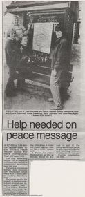
Document - Newspaper article, Diamond Valley News, Help needed on peace message, Aug 1986
A River of Life: Eltham Peace Banner 1986 The Hiroshima Day Banner was conceived by Shire of Eltham Artist in Residence, Jacky Talbot and a number of other Eltham women as part of the “As We Are” community banner project. The women wanted to do something for Hiroshima Day and suggested that a workshop be set aside to make a banner. The group promoted it at the new Community Notice Board (Arthur Street and Main Road) on Hiroshima Day (August 6) and were photographed by the local newspaper publicising the group and drawing wider community attention to the remembrance of the day. Jacky Talbot, led the team who produced the banner, approximately 4.5 metres by 1.5 metres, of sewn and painted Australian flora and fauna. Workshops were held at the Eltham Community Arts Centre at Meruka House. Peace Banner Group members included Laurel Eckersall, Anne Laurence, Betty Johnson, Margaret Johnson and Joan Maclagan. One of the creators, Joan Maclagan, further gave expression in verse – Banner for Peace The 'River of Life' with about 30 other banners went on display in the “As We Are” exhibition held at the Eltham Community Centre on 9 October 1986, previewed by the Member for Greensborough, Ms Pauline Toner, and Eltham Shire President, Mr Bob Manuell. The full display continued in Woolworths (now Coles) Arcade. The banner was also carried by the group in the 1986 Eltham Festival Grand Parade on November 8, along with other group banner projects including that of the Eltham District Historical Society, after which they were displayed in the Shire of Eltham’s tent in Alistair Knox Park.anne laurence, betty johnson, display panel, eltham peace banner, hiroshima day banner, joan maclagan, laurel eckersall, "as we are" community banner project, banner project, river of life banner, community notice board, jacky talbot -
 Eltham District Historical Society Inc
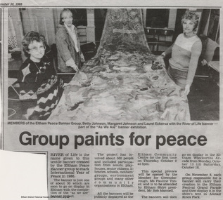
Document - Newspaper article, Diamond Valley News, Group paints for peace, 30 Sep 1986
A River of Life: Eltham Peace Banner 1986 The Hiroshima Day Banner was conceived by Shire of Eltham Artist in Residence, Jacky Talbot and a number of other Eltham women as part of the “As We Are” community banner project. The women wanted to do something for Hiroshima Day and suggested that a workshop be set aside to make a banner. The group promoted it at the new Community Notice Board (Arthur Street and Main Road) on Hiroshima Day (August 6) and were photographed by the local newspaper publicising the group and drawing wider community attention to the remembrance of the day. Jacky Talbot, led the team who produced the banner, approximately 4.5 metres by 1.5 metres, of sewn and painted Australian flora and fauna. Workshops were held at the Eltham Community Arts Centre at Meruka House. Peace Banner Group members included Laurel Eckersall, Anne Laurence, Betty Johnson, Margaret Johnson and Joan Maclagan. One of the creators, Joan Maclagan, further gave expression in verse – Banner for Peace The 'River of Life' with about 30 other banners went on display in the “As We Are” exhibition held at the Eltham Community Centre on 9 October 1986, previewed by the Member for Greensborough, Ms Pauline Toner, and Eltham Shire President, Mr Bob Manuell. The full display continued in Woolworths (now Coles) Arcade. The banner was also carried by the group in the 1986 Eltham Festival Grand Parade on November 8, along with other group banner projects including that of the Eltham District Historical Society, after which they were displayed in the Shire of Eltham’s tent in Alistair Knox Park.betty johnson, eltham peace banner, hiroshima day banner, laurel eckersall, "as we are" community banner project, banner project, river of life banner, community notice board, margaret johnson, meruka house, community arts centre, jacky talbot -
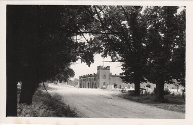 Rutherglen Historical Society
Photograph - Image, 1970s
All Saints Estate is a family owned winery established in 1864 and located on the banks of the Murray River in Wahgunyah, North East Victoria. Original owners George Sutherland Smith, and John Banks, arrived from Caithness, Scotland in 1852. They were just 23 and 20 years of age. Choosing to settle in the Wahgunyah area, they used their training as engineers from the Edinburgh Railway Institute to build a bridge over the Edwards River at Deniliquin. They were also involved in the construction of several buildings in Beechworth including the Presbyterian Church, part of the Gaol and the original hospital of which the granite facade still remains today. Smith and Banks began growing vines at ‘Sunday Creek’ closer to Wahgunyah than the present All Saints Estate winery, before relocating to build the 'All Saints castle' just three miles north of Wahgunyah, in 1864. The partners took up 100 acres and proceeded with planting vines in earnest whilst also constructing pise cellars made from the estate soil. The All Saints Estate castle was based on the design of ‘The Castle of Mey’, including turrets and a tower. The castle was constructed mainly of handmade bricks that were fired in the All Saints Estate Brick Kiln (classified on the Victorian Heritage Register) on the property. However, only the battement parapets of the lower wall and a turrets were copied, not the main castle style. The Castle of Mey, most recently owned by the late Queen Mother, was where George Sutherland-Smiths’ father was a carpenter and joiner.Black and white photograph showing a view, up a road between the Elm Tree entry drive of All Saints Winery wineries, north east victoria, wine industry, all saints winery, rutherglen, wahgunyah, winemaking, castle, winery -
 Rutherglen Historical Society
Image, 1970s
All Saints Estate is a family owned winery established in 1864 and located on the banks of the Murray River in Wahgunyah, North East Victoria. Original owners George Sutherland Smith, and John Banks, arrived from Caithness, Scotland in 1852. They were just 23 and 20 years of age. Choosing to settle in the Wahgunyah area, they used their training as engineers from the Edinburgh Railway Institute to build a bridge over the Edwards River at Deniliquin. They were also involved in the construction of several buildings in Beechworth including the Presbyterian Church, part of the Gaol and the original hospital of which the granite facade still remains today. Smith and Banks began growing vines at ‘Sunday Creek’ closer to Wahgunyah than the present All Saints Estate winery, before relocating to build the 'All Saints castle' just three miles north of Wahgunyah, in 1864. The partners took up 100 acres and proceeded with planting vines in earnest whilst also constructing pise cellars made from the estate soil. The All Saints Estate castle was based on the design of ‘The Castle of Mey’, including turrets and a tower. The castle was constructed mainly of handmade bricks that were fired in the All Saints Estate Brick Kiln (classified on the Victorian Heritage Register) on the property. However, only the battement parapets of the lower wall and a turrets were copied, not the main castle style. The Castle of Mey, most recently owned by the late Queen Mother, was where George Sutherland-Smiths’ father was a carpenter and joiner.Black and white photograph showing a view, up a road between the Elm Tree entry drive of All Saints Winery On back of photo: "250% [upper case D in small circle] All Saints"wineries, north east victoria, wine industry, all saints winery, rutherglen, wahgunyah, winemaking, castle, winery -
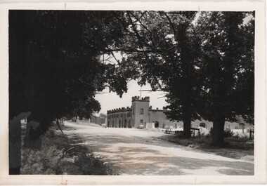
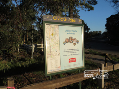 Eltham District Historical Society Inc
Photograph, Liz Pidgeon, Heritage Excursion; Eltham Lower Park, 1 July 2017
Civic Guide sign near the entrance of Eltham Lower Park with a map of the local area and an advertisement for Eltham College Newsletter No., 234, June 2017 Heritage Excursion - Saturday 1st July - Eltham Lower Park - Walk and Talk Eltham Lower Park has played an important part in the history of our area since the early days of European settlement when it was used by local residents as an informal racecourse. Prior to that its location at the junction of the Diamond Creek and the Yarra River made it an important meeting place for the Wurundjeri people. The park combines formal elements and sporting facilities with remnant bushland that is of environmental significance. It is home to sporting and horse riding clubs, popular play spaces and the Diamond Valley Miniature Railway, which attracts large numbers of visitors. The park will be the venue for our July excursion which will comprise a walk of about 3.5 km around the park and adjacent areas. Along the way we will discuss the history and natural history of the area. The path along the creek and the river provides a pleasant and scenic walk. This walk on Saturday 1st July is about 3.5 km in length and will take 2 to 2.5 hours. It will start at 2pm at the Main Road car park at the front of the park. (Melway ref 21 H 10). This sign was removed in about 2021 when works began on the building of an intersection to replace the roundabout at Fitzsimons Lane & Main Road. By May 2023 plantings in green spaces near Eltham Lower Park took place before the official opening of the new Eltham Gateway.Born Digitalheritage excursion, activities, eltham district historical society, eltham lower park, civic guide, eltham college, sign -
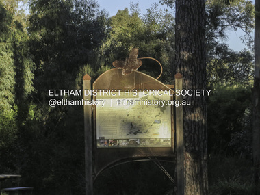 Eltham District Historical Society Inc
Photograph, Liz Pidgeon, Heritage Excursion; Eltham Lower Park, 1 July 2017
Sign at the front of the park which includes a map. Newsletter No., 234, June 2017: Heritage Excursion - Saturday 1st July - Eltham Lower Park - Walk and Talk Eltham Lower Park has played an important part in the history of our area since the early days of European settlement when it was used by local residents as an informal racecourse. Prior to that its location at the junction of the Diamond Creek and the Yarra River made it an important meeting place for the Wurundjeri people. The park combines formal elements and sporting facilities with remnant bushland that is of environmental significance. It is home to sporting and horse riding clubs, popular play spaces and the Diamond Valley Miniature Railway, which attracts large numbers of visitors. The park will be the venue for our July excursion which will comprise a walk of about 3.5 km around the park and adjacent areas. Along the way we will discuss the history and natural history of the area. The path along the creek and the river provides a pleasant and scenic walk. This walk on Saturday 1st July is about 3.5 km in length and will take 2 to 2.5 hours. It will start at 2pm at the Main Road car park at the front of the park. (Melway ref 21 H 10). This sign was removed in about 2021 when works began on the building of an intersection to replace the roundabout at Fitzsimons Lane & Main Road. By May 2023 plantings in green spaces near Eltham Lower Park took place before the official opening of the new Eltham Gateway. The sig Born Digitalelection day, heritage excursion, activities, eltham district historical society, eltham lower park, sign -
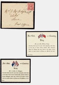 Lara RSL Sub Branch
Sympathy Cards Mc Intyre, 1917 and 1918
Standard sympathy cards sent by family acknowledging the loss of their sons killed during World War OneStandard sympathy cards sent by parents acknowledging letters of sympathy sent to them on the loss of their sons.2 Cards and one envelope stuck to white a4 paperEnvelope Addressed to Mrs J MC Intyre Elcho Lara Australia, includes a one penny stamp. Two standard printed Cards " Thanking you for your kind Sympathy ........." . One card from Mr. and Mrs. Lodge for the loss of their son Corporal James A lodge ( France March 26 1917) Little River and the other from Mr. and Mrs. J Duggan Lara on the loss of their son Private Horace James Duggan. (France 27th March 1918) For God, King and Country with the Australian and English flag. -
 Kew Historical Society Inc
Booklet - Old Kew Golf Links Estate, 1926
Subdivision plans and real estate flyers/brochures reveal a number of aspects of urban development and history. The Kew Historical Society's collection of these plans, as well as advertisements extracted from magazines, cover key aspects of community development and architectural history of Kew and Kew Eat as well as surrounding suburbs. While most of the plans in the collection were gifted to the Society by the former City of Kew, a number of other plans and advertisements have been donated by individuals, of which this is an example.8-page brochure advertising 80 residential home sites for sale in a subdivision called the 'Old Kew Golf Links Estate'. These sites had historic importance in Kew's history as they had previously belonged to Kodak Pty Ltd who were refused permission by Kew Council to use the land for industrial development. The estate, advertised was advertised as being within five miles of Melbourne. The brochure is notable as it includes photographs of Kew East Primary School, the former Kew Golf Club clubhouse, and 'The Moorings' Boathouse (aka Chipperfield's Boat House). The aerial photograph, overlaid with names of notable sites, on the final page is of interest as it shows the area before the intrusion of the Eastern Freeway, which resulted in changing the course of a section of the Yarra River. old kew golf links estate, subdivision -- kew (vic.), subdivisions -- kew east (vic), chipperfield's boathouse, kew east primary school, kew golf club -
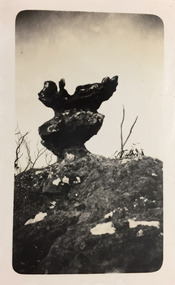 Kew Historical Society Inc
Photograph - Grampians, 1924
Henry Beater Christian (1886-1962) , was a descendant of one of the earliest settler families in Kew. Employed at the Kew Asylum as a 'public servant', he was a skilled amateur photographer, photographing numerous scenes in Kew and on his travels around Victoria. The majority of his photographs date from 1916 to 1929. His finest photographs are housed in two photograph albums. Digital copy of a photograph from page 12 of the 47-page photograph album containing 261 gelatinous silver images, loaned by Diane Washfold with permission given to digitise and hold a copy in our collection. The first and last pages in the album document the Yarra River at Studley Park and at Kew. The remainder of the album includes photographs of walking and car tours in rural Victoria including 'wilderness' areas in the Grampians, Gippsland and the High Country. Six album pages document a camping trip by Henry Christian to the Grampians in September 1924. The photos include pictures of lookouts, and natural features including rock faces and waterfalls, as well as his camp site. This photo is of a self-standing rock on what is probably the Mt Victory trail. "Mt Victory / Grampians / 9.24"henry beater christian (1886-1962), landscape photography, christian-washfold collection, photograph albums, grampians, mt victory, gariwerd -
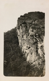 Kew Historical Society Inc
Photograph - Grampians, 1924
Henry Beater Christian (1886-1962) , was a descendant of one of the earliest settler families in Kew. Employed at the Kew Asylum as a 'public servant', he was a skilled amateur photographer, photographing numerous scenes in Kew and on his travels around Victoria. The majority of his photographs date from 1916 to 1929. His finest photographs are housed in two photograph albums. Digital copy of a photograph from page 13 of the 47-page photograph album containing 261 gelatinous silver images, loaned by Diane Washfold with permission given to digitise and hold a copy in our collection. The first and last pages in the album document the Yarra River at Studley Park and at Kew. The remainder of the album includes photographs of walking and car tours in rural Victoria including 'wilderness' areas in the Grampians, Gippsland and the High Country. Six album pages document a camping trip by Henry Christian to the Grampians in September 1924. The photos include pictures of lookouts, and natural features including rock faces and waterfalls, as well as his camp site. This photo is of one of a well-known cliff face on one of the walking trails. Unitled [Grampians]henry beater christian (1886-1962), landscape photography, christian-washfold collection, photograph albums, grampians, mt victory, gariwerd -
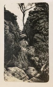 Kew Historical Society Inc
Photograph - Grampians, 1924
Henry Beater Christian (1886-1962) , was a descendant of one of the earliest settler families in Kew. Employed at the Kew Asylum as a 'public servant', he was a skilled amateur photographer, photographing numerous scenes in Kew and on his travels around Victoria. The majority of his photographs date from 1916 to 1929. His finest photographs are housed in two photograph albums. Digital copy of a photograph from page 13 of the 47-page photograph album containing 261 gelatinous silver images, loaned by Diane Washfold with permission given to digitise and hold a copy in our collection. The first and last pages in the album document the Yarra River at Studley Park and at Kew. The remainder of the album includes photographs of walking and car tours in rural Victoria including 'wilderness' areas in the Grampians, Gippsland and the High Country. Six album pages document a camping trip by Henry Christian to the Grampians in September 1924. The photos include pictures of lookouts, and natural features including rock faces and waterfalls, as well as his camp site. This photo is of one of opposing rock faces on one of the walking trails. Unitled [Grampians]henry beater christian (1886-1962), landscape photography, christian-washfold collection, photograph albums, grampians, gariwerd